SEOUL - north | SEOUL - south
Day Trips from Seoul | Busan | Best Collections
🌸Festivals ( Seoul • Busan )

Han River (Hangang) Cruise 한강유람선
서울특별시 영등포구 여의동로 290 (여의도동) 한강유람선 선착장 | 290 Yeouidong-ro, Yeongdeungpo-gu, Seoul
Dock: 10:00-22:00
refer to chart below
Yeouinaru (line 5, exit 3). 5 mins walk towards Han River (Hangang) to reach E-land Cruise Yeouido Dock.
www.elandcruise.com
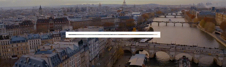
The popular Han River (also refer as Hangang) Cruise is operated by E-Land Cruise since 1986. It brings visitors cruising between east and west of Seoul at fairly affordable rates from 15,000 won (per adult) day cruise to 89,000 won dinner fireworks cruise.

Cruising on Han River is one of the best ways to enjoy beautiful views of Han River (day, sunset & night) and its many tourist attractions (e.g. Bamseom Islet, Jeoldusan Park, 63 Square, Namsan Seoul Towel, Jamsil Stadium) along the courses.
There are different themed cruises that include live performances, lunch buffet and dinner buffet as well.
The course that cruises East of Han River and passes under Banpo Bridge (also refer as Banpo-daegyo) at night is popular for the spectacular daily 20 mins Moonlight Rainbow Fountain Show (Apr-Oct only) and Saturday's Fireworks Show .
The Story Cruise travelling on the West course is another popular option as it provides many flexible timings for cruise passengers.

To enjoy Han River (Hangang) on land , you can rent a bicycle (near Yeouido Cruise Dock) for a relaxing ride along the cycling path for a different and memorable experience of Han River altogether.

KoreaToDo TOP PICKS - Tours, Activities & Discount Tickets
➥ Handpicked experiences by KoreaToDo for their uniqueness, value, popularity, price competitiveness and at times, tedious to reach by public transport.

Seoul Eland Hangang River Cruise (Day Cruise)
40 mins, multiple timings

Eland Han River Cruise & Ashley Marine Buffet at Dock
multiple cruise timings

Seoul Eland Hangang River Cruise (Sunset Cruise)
40 mins, 6pm

Han River Sevit Island Yacht Experience (pets allowed)
enjoy Han River to the fullest

Seoul Eland Hangang River Cruise (Starlight Cruise)
50 mins, 10pm, Jazz live

Discover Seoul Pass (Lotte World, COEX Aquarium, Han River Cruises, etc)
free access to >60 attractions

Seoul Eland Hangang River Cruise (Moonlight Cruise)
70 mins, 7/8.30pm, Jazz live

Korea Rail Pass (KR PASS): KTX Bullet Trains to Busan & others (2, 3, 4 or 5 Days)
instant pass & tourist exclusive!
♔ KoreaToDo recommends Klook.com , Asia leading in-destination service provider.

🌸SPRING PICKS🌸 Handpicked Experiences from Seoul

Chasing Cherry Blossom & Spring Flowers Day Tour
29 Mar - 14 Apr 2024
3 best spots of the day in Seoul/Gyeonggi

Taean Tulip Festival & Strawberry Picking Day Tour
12 Apr - 7 May 2024
500g strawberry picking

Jeonju Hanok Village, Wansan Park & Gakwonsa Temple Day Tour
8-23 Apr 2024
King Cherry Blossom Festival

Pink King Cherry Blossom Tour (Spring Flower Festival, Gaesimsa & Munsusa)
14-29 Apr 2024
king cherry blossoms are larger & denser

Hwadam Botanic Garden, Nami Island & Gangchon Railbike Day Tour
29 Mar 2024 ~

Pink King Cherry Blossom Tour (Wansan Flower Garden, Jeonju Hanok Village)
15-28 Apr 2023
& Gakwonsa Temple
Other KoreaToDo Collection that you may like:
Han River: Best Hangang Parks and Views
Ttukseom Hangang Park - Duck boat ride on the river?
LOVE Museum - Adults Only
Noryangjin Fish Market - Have a meal on your seafood purchased
Still looking? Explore KoreaToDo handpicked collection of:
Top Hidden Attractions & Secret Places to Explore in Seoul
Seoul - North of Han River
Seoul - South of Han River
- Skip to main content
Trazy - Book Travel Crazy Things to do in Asia
Han river ferry lunch/dinner cruise, how to book.
- Destination
Experience Carousel
Experience basic information, basic information, coupons & promos.

Meet Location
- Yeouido Han River Ferry Terminal near Yeouinaru station (Line 5)
- Han River Cruise
- Lunch or Dinner
Check out Photo reviews


Please keep in mind
Cancellation policy, this activity is included in.

- Must Do / Seoul Travel Blog
Hangang River Cruise And Other Ways To Enjoy The Han River Seoul
· Updated April 11, 2023 THIS POST CONTAINS AFFILIATE LINKS
Korea’s main river, runs from Gangwon-do towards Gyeonggi-do. Cutting through the middle of Seoul all the way to the Yellow Sea. The ancient river has witnessed the history of Korea for over more than 5 thousand years. Now the Han river offers nice outdoor activities like a Hangang river cruise, outdoor swimming pools, beautiful parks for the citizens of Seoul and foreign tourists. Read on to find out all the details about ‘ Ways to enjoy the Han River Korea ‘!

About The Hangang River
1. regular hangang river cruise, 2. dinner hangang river cruise, 1. han river parks, 2. walking trails along the han river, 4. han river night markets, 2. outdoor han river swimming pools, 3. swan boats, 4. kayaking and paddle boarding on han river, 5. summer water gun festival, how to go to the hangang river, frequently asked questions.
The Han river and the land beyond played a vital role in Korean history as more than 2000 years back, the 3 kingdoms were fighting to take control of this area as the river played a vital part in doing trade with China. Now the river is a voted as the 2nd most scenic spot of Seoul, following Namsan Mountain as being the best tourist spot. The lowest parts of the river in Seoul are lined with walkways, cycling lanes, public parks, restaurants, sport courts and swimming pools.
Hangang River Cruise Tours
On of the best ways to enjoy the Han River and admire the Seoul skyline is by boarding one of the Hangang river cruises. There are multiple companies running Han river cruise tours, but the most known one is the Eland Cruise leaving from Yeouido Park.
Eland offers 4 different types of Hangang cruise tours, namely the Story Cruise, Moonlight Cruise, Music Cruise and the Fireworks Cruise. During the summer months the cruise runs 6 times a day, once at 12 AM and then 5 times after 7 PM. Sites you can see from the Han river tours are the 63 City Building, N Seoul Tower, the Floating Island and the stunning Banpo rainbow bridge. All ferries have an outdoor deck and indoor sitting area filled with chairs.
Tickets have to be bought online in advance. This cruise is extremely popular and tickets sell out fairly quickly, especially in peak season. Make sure to book at least 2 weeks in advance. Han river cruise price start at 14 000 krw. Find more info here. Another option is to take a (private) yacht tour of the river. Starting price for the yacht tour is 20 000 krw. More info here.

** I have been on all 4 Hangang cruises and prefer the story cruise during day time and the fireworks cruise at night time in Seoul . From the boat you can see the fireworks and the rainbow bridge at the same time, which is really amazing. **
Additionally you can opt for an Eland Hangang cruise + Ashley Marine Buffet or a dinner (fireworks) cruise. These Han river cruise tours include a wonderful buffet. For the first option, the buffet is served after the cruise on a different boat. The latter cruise has a buffet served during the cruise. Food includes ribs, salad, seafood, chicken and much more. More info here.
Other Things To Do Along The Han River
There is more to do at the river than going on a Hangang river cruise. Along the river there are multiple parks, swimming pools, cycling lanes and much more. Listed below are the most popular things to do at the Han River.
You can find more than 12 Hangang River parks, all the way from the Jamsil area to Mapo-Gu. It is one of the most popular FREE outdoor activities all year around. These parks offer green spaces which can be enjoyed by playing children, couples going on a summer stroll or just for working out!
1.1 Yeouido Park
The most popular park along the river is definitely Yeouido park, this vast park is a go to place during spring in Seoul ! The park is divided into 4 main sections, namely the Traditional Korean Forest, Grass Square, Culture Square, and Nature’s Ecosystem Forest. Many festivals and events are held on the culture square. This is also the area where the Han river tours are leaving from.
If you visit the park during the warmer months, you’ll see many Koreans with a small tent which protects them against the sun. These tents can be rented at Yeouido Park. Find more info here.

1.2 Jamsil Park
The Jamsil Hangang Park lies next to Jamsil Sports Complex, Lotte World, and Olympic Park. It is a great place to enjoy the beautiful Han river, but is also a place of learning about nature at the Jamsil Water Reserve.
You can find 4 walking trails along the river:
- 1st trail : Jamsil Stadium, Gwangnaru Hangang Park and Amsa Ecological Park
- 2nd trail : Seoul Forest, Ttukseom Hangang Park and Gwangjin Bridge
- 3rd Trail : Seorae Island in Banpo Hangang Park and Ichon Han River Park
- 4th Trail : Mangwon Hangang Park, Seongsan Bridge and Mapo Bridge
For more information about each trail, check out Seoul’s official website .

These parks are also perfect for cycling ! You’ll be able to find well maintained cycling routes all along the river. If you don’t have your own bicycle you can rent on from one of the many cycling rental shops along the river (most of them located close to the subways stations). If you have a Discover Seoul Pass , you can rent a bike for free and use it for up to 24 hours.
There are two types of rental services:
PAID Where : below you can find a list of cycling rental shops (this is just a short list of the most popular locations). Jamsil Sports Complex Station (Line 2, Exits 6,7), Walk 750 meters Yeouinaru Station (Lines 5,9, Exits 2,3) Ttukseom Resort Station (Line 7, Exits 2,3), Walk 20 meters Ichon Station (Lines 4, Jungang, Exit 4), Walk 500 meters When : 9 am ~ 8 pm (opening times may vary depending on the shop) Cost : Full day single bike 15,000 won or per hour 3,000 won; Tandems are 6,000 won/hour.
FREE Where : find the different locations here . When : opening times depends on different rental shops How Much : Free, depending on the shop available for a couple of hours or a full day.
The river parks are the perfect location for night markets; with the beautiful Hangang nightscape on the background. The Bamdokkaebi Night Markets can be found in 6 different locations in Seoul with two of them along the river, namely Yeouido and Banpo. The markets run from March till October on Fridays, Saturdays and Sundays from 6 pm ~ 11 pm.
4.1 Yeouido World Night Market
The evening market in Yeouido is an international night market with sellers from all over the world selling exotic world food, hand made objects alongside exciting performances from local and international artists. This market is located next to the Hangang River Cruise terminal, so perfect to combine these two activities.
4.2 Banpo Romantic Moonlight Market
This is literally a market lit by the moon; with artist flea markets, local art programs, food stalls; perfect for a romantic evening along the Han river.
For directions to each park, check out this Han River Map .
Swimming pools offer the perfect escape from the summer heat! Seoul metropolitan City has built more than 6 pools spread out along the Hangang river both on the north and south sides.
Each pool has different features, some included slides and water activities while others are just a normal plain pool. The pools open each year during July and August only. All pools are perfectly maintained and daily water quality tests are done to ensure a safe swimming environment.

The pools are open daily from 9am till 10pm during July and August. Entrance price is 5,000 won (adults), 3,000 won (children). Note, these pools can get super overcrowded. More info here .
What about having a little fun and workout on the river? When in Korea it’s a must to try the ‘Swan Boats’. Literally boats in a swan shape. There are dedicated areas where you can rent a duck boat per hour, perfect for 2-4 people. If you don’t want to peddle yourself, you can hire a motorized swan boat, which is also a bit more expensive.
The swan-boat-paddling area is in Yeouido, on the right of the Eland Hangang river ferry cruise terminal. Price for 60 minutes (per boat) is 15,000 won, 20,000 won for the motorized boat.

At the Ttukseom Han River Park is the kayaking and paddle board club. At the club you can rent the equipment and get brief explanation from an instructor. These activities are especially great during summer as the water will help you cool down from the humid Korean summer weather. This activity has to be booked in advance online. Find more info here.
Each year in July the Summer Water Gun Festival takes place at the Some Sevit Floating Island near Banpo Bridge. During the first 2 hours of the party, there will be an open bar with unlimited beers and cocktails. Amazing DJ’s and artists will be playing and after 6 pm, the foam party will kick off. Find more info here.
There are multiple ways of getting to the Han river as it is running through the middle of Seoul. Your route will depend on the part of the river you are planning on going to. Here are just a few subway stations located within walking distance of the river.
- Ttukseom Resort station: Exit #2 or 3 of (Seoul Subway Line 7).
- Cheonho station: Exit #1 (Seoul Subway Line 5 & 8), walk about 20 min.
- Yeouinaru station: Exit #2 or 3 (Seoul Subway Line 5).
- Dangsan station: From exit #4 (Seoul Subway Line 2), walk about 10 min.
The best time of day to go on a Han River cruise largely depends on your preferences. If you prefer a serene and romantic atmosphere, a sunset cruise is recommended. However, if you prefer a more lively and festive atmosphere, a nighttime cruise with live music and colorful city lights is recommended.
A Han River cruise typically lasts for about an hour or two. However, the duration may vary depending on the type of cruise you choose, as well as the time of day and season.
Yes, there are a few safety precautions to keep in mind before going on a Han River cruise. It is recommended that you wear comfortable and non-slip shoes, as the decks of the boats can be slippery. Additionally, be sure to bring a light jacket or sweater as it can get chilly on the river. Finally, be sure to follow the safety guidelines provided by the cruise operator, such as staying seated while the boat is moving and keeping your belongings secure.
Like this post about going on a Hangang River Cruise? Why not pin it?

Have you been on a Han river cruise? Have any questions about these Han ferry tours? Are you planning on going to the Han River? Have anything to add to this article? Let me know in the comment section below.
Tags: Outdoor River
You may also like...

Seoul Itinerary 7 Days | What To Do When 7 Days In Seoul
April 6, 2023
by Marie · Published April 6, 2023

Seoul In Spring: Best Things To Do And To Eat (March, April, May & June)
April 2, 2023
by Marie · Published April 2, 2023

How Much To Bring To Korea For 7 Days
February 9, 2024
by Marie · Published February 9, 2024
4 Responses
- Pingbacks 0
Thanks for sharing this guide. this is really very nice post i glad to read this info. In Korean history, Han river played a central role. The rise and fall of the nation depended on taking the Han river.
Great post! This is very helpful for those who want to visit this place. Really want to experience Han River Cruise.
Can we buy Hangang River Story cruise ticket on the spot? I have just known that it should be bought in advance, however we have to leave Korea tomorrow. So sad if I can’t try this experience.
Yes you could also buy the tickets on site but during the busy periods they can be sold out. So if you want to be sure then buying them online is the best option.
Leave a Reply Cancel reply
Your email address will not be published. Required fields are marked *
- Next story Horse Riding In Jeju, South Korea
- Previous story Seoul In Spring: Best Things To Do And To Eat (March, April, May & June)
DON’T MISS OUT

- Affiliate Disclaimer
- Privacy Policy
The Essential Han River Guide

The Han River is in many ways the heart of Seoul.
Not only does it divide the north and south of the city, in many ways the old and the new, but it is also one of the most loved locations in the city.
As many rivers help define cities – the Thames in London and the Yarra in Melbourne to name but two, the Han River helps define Seoul.
It’s easy to say that the Han River is one of the must-visit locations in Seoul . It’s also most definitely true! If you are in Seoul and haven’t visited the Han River then you are missing out.
You may also hear of the Han River referred to as ‘Hangang’ (pronounced as Han-gang). This is the rivers name in Korean and is the romanisation of the Korean word 한강.
With the river being such a central pillar of Seoul, make sure that you get the chance to visit it. It may ‘only’ be a river, but it’s a very important one, and one with many different activities!
This post contains affiliate links. For more information, read my affiliate disclaimer .
When to Visit the Han River
One of the questions I get asked very often is ‘when is the best time to visit the Han River?’. The best time to visit is definitely whenever you are in Seoul! However, here’s a bit more detail.
Before you even consider when the best time to visit the Han River is, it’s best to ask yourself when is the best time to visit Seoul? Every season has different attractions and highlights.
Generally, the best season to enjoy the most Han River activities is summer. This is because it’s not only the warmest season but also Han’s busiest season. All of the water activities will be open.
However, summer also brings crowds. If you plan to visit some of the popular Han River parks such as Yeouido, Ttukseom, or Nanji, then you might find summer quite crowded.
Spring and Fall are also great times to visit the river as they often have fewer crowds and milder weather. Just be careful, as it can get quite chilly after the sun goes down.
In Spring, there will also be cherry blossom festivals at some of the Han River parks. These festivals are stunning and the river background makes them even more so.
Winter is the hardest season in which to visit the Han River because it is so cold. While the Han River can still be enjoyed, make sure to wear warm clothes!
In winter, there will be far fewer events and activities at the river. However, many activities such as picnicking, biking, and strolling along the river can still be enjoyed.
While I still recommend at least visiting the river in winter, there are also a lot of other activities that you can enjoy in winter .
Best Time of Day to Visit

If you want a stunning view, visit at sunset!
While you can visit the river at any time, I would recommend two times in particular. Firstly is in the morning, secondly is at dusk.
The morning is a great time to visit the river as it is well before the crowds will begin to appear. Before 1 pm, most of the people you come across will be exercising. There won’t be many picnickers or couples!
During the afternoon the river will get busier until around 8 pm. 6 pm to 8 pm is peak time at Hangang. However, it is for good reason.
Since the river flows east to west, it is a fantastic sunset viewing location. In fact, many of the best sunsets in Seoul can be witnessed along the banks of the Han River.
While this is the busiest time, it is also the most beautiful. If you want to visit and avoid the crowds though, make sure to go before 1 pm!
How to Get to the Han River
Since the Han River flows right through the centre of Seoul, there are hundreds (if not thousands) of different ways to get to the river.
With that being said, these are the directions to get to a few of the more popular locations on the river.
How to Get to Yeouido

Despite the name, the best subway station to reach Yeouido Hangang Park is Yeouinaru Station . Yeouinaru is located on Line 5 (purple line). Exit the station via exit 2 or 3.
Both of these exits are located right next to the Han River park and they are located right next to each other. However, exit 2 is a more direct way to the various food stalls and other vendors.
How to Get to Ttukseom Hangang Park

Again, despite the name, the best station to reach Ttukseom Hangang Park is actually Ttukseom Resort Station . The station is located on Line 7 (dark green line).
From the station, exit from either exit 2 or 3. They are located just opposite each other and both lead down straight into the Ttukseom Hangang Park.
How to Get to Banpo Hangang Park

To get to Banpo Hangang Park you have two choices. The first involves a bit more walking, but the walking is alongside the Han River. The second option is more direct but involves covering a block or two of the city.
The first method is to go to Dongjak Station on Line 4 (light blue). From there, exit the station via exit 2 – this will take you right onto the banks of the Han River. Follow the river east for 10-15 minutes and you will arrive at Banpo Han River Park.
Secondly, you can arrive at the Express Bus Terminal Station on Line 3 (orange), 7 (dark green) and 9 (light brown). Exit from Exit 8-1 and go straight until you come across a big highway (it should be the third road to the right).
Follow the highway straight and you will come across some stairs which will take you into the park.
How to Enjoy the Han River
There are a lot of different ways that the Han River can be enjoyed. The river has become a big attraction for both locals and tourists alike and has been designed to entertain people.
Some of the most popular ways to enjoy the Han River are with a Han River Cruise , as a picnic location, and as an exercise location for everything from walking to skateboarding and biking.
However, there are even more activities that are a bit more unique. Many of the bridges have stunning lighting at night and some even put on light shows.
There is even a museum/park called the Seoul Battleship Park which has two retired navy boats as well as a submarine!
On top of this, there is a large variety of different water activities that you can enjoy. From cruising on the Han River to taking out peddle boats, kayaks , or having jet-ski rides.
All of this is to say, there isn’t a lack of activities to do on and near the Han River. Whether you want an action-packed day or would just prefer to relax and enjoy the atmosphere, the river has you covered.
Picnicking at the Han River

A picnic on any riverside is usually a great time. However, Korea has a few conveniences which make picnicking at the Han River the ultimate ‘only in Korea’ activity .
Not only are tents and mats available for hire, but they are also virtually free. Mats can be found as low as 2000KRW (less than $2). However, they do require a deposit in order to make sure you return the item. Tents can be hired from 10,000KRW on Trazy .
If you get hungry while picnicking, why not order some food straight to your tent. No, seriously! You can deliver food right to your tent!
Although most of the delivery services are Korean, there are also some that have English service available. You will find flyers for food all around popular picnic areas such as Yeouido.
If you are planning to enjoy a picnic on the banks of the Han River make sure to bring a picnic kit! These are the best items to enjoy summer (or spring or fall!) evening at the famous Hangang.
Picnic Essentials – Bluetooth speaker , outdoor blanket , paper cups , tumbler , picnic mat , bug repellent , lantern , hand sanitizer .
It can be difficult to order food if you can’t speak Korean. Luckily, there are a few great services that can help with ordering food. One such service is Gowonderfully . They are fantastic for quick tasks when you need someone fluent in Korean!
Han River Cruise
One of the most popular ways to enjoy the Han River – and indeed one of my favourite ways, is to take a Han River cruise.
Although this might sound expensive, it really isn’t! Cruises can be enjoyed for less than $15 per person. They are definitely one of the best ways to enjoy the Han River and to see the sights that it offers!
If you would like to eat, then most of the cruises also offer food onboard which can be enjoyed by customers.
The cruises go from many different points along the Han River. Generally, I would recommend taking a cruise from a central point in the city. Locations like Yeouido have a lot of highrise buildings and make for some stunning scenes.
If you are interested in taking a cruise on the Han River, make sure to check out these deals.
Another way to enjoy the warm weather is to bike along the banks of the Han River. Nearly the whole river has paved paths on both sides. What’s more, these paths are very well maintained and are flat and smooth.
Bikes can be hired for very cheap prices – from less than $1 per hour you can enjoy biking along the Han River. If you purchase more credit, you can even get discounts.
The bikes can be hired from an app which is now provided in English. Although the app is not very good (it performs terribly at times), it is usable.
Balance can be topped up by a variety of different methods and discounts can be applied when purchasing longer periods of time.
These bikes can be hired not only at the Han River but all over the city! In fact, the green and white bikes can be found on nearly every 2nd or 3rd block in the city.
Once you understand how to use the app, the bikes are very easy to hire and return. They can be returned to any bike stand in the city, and as mentioned above, they are very common.
If you want a new way to explore the Han River or even the city of Seoul, make sure to check out the bikes in Seoul!
Watching the Sunset
Watching the sunset is one of my favourite activities at the Han River – not only because it’s a large open space, but also because the river flows east to west. Since the sun sets above the river, this makes for some beautiful views.
There are fantastic views all around the river, and I would recommend watching the sunset wherever is most convenient for you. I have a whole post dedicated to the best sunset locations in Seoul and I could go on and on!
Perhaps the best place to watch the sunset, though, is from some of the bridges that cross the Han River. Nearly all of the bridges have footpaths and stairs leading onto them.
If you can’t make it to the bridges, or would simply prefer to not walk across them, then the sunset view from the banks of the Han River is also stunning.
Although there are many fantastic sunset locations along the river, one of my favourites is at Ttukseom. The view towards Namsan Tower is breathtaking and one of the best that you can see in Seoul!
Water Sports

Being a river, Han has a lot of different water sports which can also be enjoyed. From windsurfing to Flyboarding , there really is a lot to be enjoyed here.
Most of the water sports take part in the major Han River hubs. This means Yeouido and Ttukseom primarily, although there are a few other areas along the river which also offer water activities.
If you are feeling up for something adventurous then I would recommend trying out flyboarding. I’m almost certain you have seen videos of it before, and it is a lot of fun!
If you are looking for something a bit less extreme, then there are also pedal boats and other activities which can be enjoyed.
Han River Swimming Pools
At the peak of summer (mid-July to mid-August), the Han River swimming pools open. These swimming pools are located all over the Han River, and can be found at Ttukseom, Yeouido, Gwangnaru, Mangwon, Jamwon, Jamsil, Nanji and Yangwha Han River parks.
The pools have a small fee – Children are 3000KRW, youths are 4000, and adults 5000. Children under six years of age get free admission.
The pools are open to all ages, however, they are split into different areas. There are children’s pools and close by the adult pools can be found.
Located near the pools are showers and snack bars, and this makes them an all-in-one place to have some family fun.
Ttukseom Hangang Park has the most famous of the pools, however, it can be quite packed at times. If you want to avoid the crowds, try to visit in the morning (before noon).
The pools are open from 9 am until 7 pm. However, as mentioned above, you can expect these pools to be quite busy – especially after lunchtime.
Best Locations to Enjoy the Han River
The Han River is massive. It winds through Seoul for many kilometres and has many distinctive and unique areas to visit. On top of that, there are tens of different Han River parks. Possibly even hundreds!
Some of the more popular locations along the Han River are well known by all – Yeouido Hangang Park, Ttukseom Hangang Park, and Banpo Hangang Park to name three.
I will cover these parks before discussing a few of the lesser-known parks along the river banks.
Yeouido Hangang Park

Yeouido Han River Park is perhaps the most well-known river park in Seoul. It is located in a very wealthy part of Seoul – right next to the general assembly building.
The park itself is located on Yeouido , an island which is located in the Han River. The island can be accessed from the purple line and also from the dark brown line. The station itself is located very close to the park and makes it very easy to access.
Yeouido can be very crowded at times as it is very well-known and liked. However, the upside of this is that it means there are a lot of activities and food vendors on site.
There are both grassy areas which are great for sitting, and concrete areas which are for fantastic for skateboarding and biking.
To take advantage of this, mats and tents can both be hired from the exit of the subway station and online . More interestingly, there are also segways and hoverboards for hire if you want another way to explore the park.
For around 10,000KRW per hour, you can hire these electronic devices and explore the riverside. It’s a fantastic way to spend a summer evening!
Ttukseom Hangang Park
Ttukseom Han River Park is another of my favourites. This is another of the more famous parks in Seoul and holds many performances and festivals every year – especially in the warmer months.
The Han River park is located at Ttukseom Resort Station (뚝섬유원지역) on line 7. The train station is located directly above the park and can be accessed with a very short walk from the station.
J-Bug (a big, seemingly floating, building that overlooks the park) is another attraction that makes Ttukseom unique. This building has a few exhibitions as well as some viewpoints to take in the sunset
Under the structure, there are a lot of paths that can be explored. If you would prefer to rest, then you can enjoy the grass areas with mats that can be hired. Similar to Yeouido, there are also bikes which can be hired.
While Ttukseom doesn’t have as many food options (unless you order), there is a big convenience store which has not only typical convenience store food, but also a few meal foods such as chicken.
Ttukseom, while still quite crowded at times, tends to be less busy than Yeouido. While Yeouido has more food options on sight, this can easily be overcome with delivery food.
One of Ttukseom Hangang’s biggest attractions is that there are a lot of festivals and events held throughout the year. From concerts to talk shows and dances, there is always something happening at Ttukseom Resort Station.
Banpo Hangang Park

Banpo Han River Park is another of the popular Han River parks in Seoul, and one that is famous for a unique reason.
While not as maintained and built up as Ttukseom and Yeouido Hangang parks, Banpo has one attraction which makes it stand out amongst the rest – that attraction is the waterfall light show of Banpo Bridge.
In the warmer months, at set times, the bridge will spray water out the sides and paint the water with rainbow coloured lights. It’s a stunning sight!
Banpo Hangang Park isn’t as popular of a picnic spot as the two above parks, and as such, it’s often a nice park to visit if you would prefer to stay away from the crowds.
While the park is by no means worse, it is different. It is less built up and has fewer facilities than the other parks. However, it does have some unique attractions that make it worth visiting!
Nanji Hangang Park

This Han River park is located close to Hongdae, at World Cup Stadium . World Cup Stadium is a large area containing not only the World Cup Stadium but also a cluster of other parks.
The World Cup Stadium Parks are all located close to the station and are within a short walking distance of the exit.
Although the park itself is made up of five smaller parks, the one in question is Nanji Hangang Park. This park is located on the banks of the Han River and is well maintained.
When I visited the park in 2018 it was a great place to have a picnic. However, it didn’t have many facilities as it is one of the lesser-visited Han River parks.
Nanji has some stunning views though, and this is what makes it stand out to me. On top of this, it’s rarely ever crowded and this makes it a great place to have a more private picnic in the evening.
Jamwon Hangang Park
Jamwon is another park found on the orange line. Jamwon is one of my favourite parks as it has more trees and shaded areas than the other parks on this list.
This is especially key in summer when the weather easily gets into the high 30’s. Although the humidity remains, the shade does provide some form of relief from the relentless heat.
Jamwon also has some fields which are famous for their Pink Muhly Grass in the fall. This easily makes for one of the most beautiful Han River parks in the city, and if you haven’t yet seen it in fall, I highly recommend it!
If you can’t visit in fall, consider visiting in spring. In spring, there are poppies blooming and they
There are also bikes available for hire. From 1000KRW per hour , these bikes can be hired and enjoyed. There are bike paths along the side of the river which are well made and flat.
If you are looking to visit a Han River Park in spring or fall then I would recommend Jamwon Han River Park.
Hapjeong Hangang Park
Hapjeong has less of a Han River Park, as it isn’t a dedicated area for a park. However, it has some nice riverside paths as well as a few fantastic seating areas that make it ideal for a picnic. So while Hapjeong isn’t technically a Han River Park, it’s still a very nice place to visit.
Hapjeong Han River Park can be easily reached from Hapjeong Station and is one of the most enjoyable parks along the banks of the Han River.
To my knowledge, tents and mats can’t be hired here, however. So make sure to bring your own picnic gear. Food is available at nearby stores, and it’s easy to carry food down to the riverside.
It also has one of the most beautiful views out of all of the Han River parks. Looking towards Yeouido, the view is fantastic.
Finally, Hapjeong is located just across the bridge from Yeouido. If you fancy the best view, you can start at Hapjeong and cross the bridge towards Yeouido. This is one of the best sunset views in the city!
One of the best Han River activities is to watch the sunset or sunrise on the banks of the river. So much so, that the river is often regarded as having many of the best views in the city .
I can attest to this, as I have spent months exploring different locations on the Han River and finding, what I believe, are some of the best views that the city has to offer. These are the best Han River views!

Ttukseom Resort Station has one of the most popular Han River parks, and it is for good reason – the park also has one of the best Han River views in the city.
The west-facing view from the park provides a breathtaking view of Namsan Tower , one of Seoul’s most famous landmarks. The tower is iconic and standing atop Namsan (South Mountain), the view is a must-see in Seoul.
This is even truer because the sun sets behind Namsan, highlighting the tower and making its shadow stand out.
Ttukseom also has a second view which although not as iconic, is also very stunning! That view is the view directly across the river from the park.
Across the river are a few different high-rise buildings with a variety of lights. These lights reflect off the surface of the water, and in turn, make for a fantastic reflection photo.
Dongho Bridge

Dongho Bridge is the bridge that crosses the Han River between Oksu and Apgujeong. The view on the eastern side of the bridge is one of my all-time favourites in Seoul and it is unforgettable when coupled with a good sunset.
This is one of the less cluttered views as it is in an area where there aren’t as many high-rise buildings. Due to this, you get to see the vastness of the Han River. This makes for some fantastic reflection photos!
Dongjak Bridge Emart

This one might sound a little funny, but hear me out! Did you know that there are two Emart 24 convenience stores located on either side of Dongjak Bridge? Well, there are, and they provide some amazing views!
Dongjak Bridge is located more towards the east of Seoul, and the bridge itself isn’t as famous as many other bridges. However, it also has a unique attraction in the two convenience stores located on the bridge.
The Emart stores are 3 stories tall and look nothing at all like convenience stores. Rather, they look like observatories. Inside these buildings are a convenience store, a small library, a cafe, and a deck on the roof.
You don’t need to spend much at these stores as they sell everything from ramyun to restaurant food. Once you get some food, you are welcome to enjoy the fantastic river views from the observation areas.
Despite being Emart 24, these stores are a great location for a date. They have some of the best views and are very affordable. If you would prefer something a bit fancier, then they also offer more expensive foods and coffee!
Haneul Garden
Although located a short distance from the river itself, Haneul Garden provides some of the best river views in the city.
The park is very famously known for being a landfill that was converted to one of Seoul’s top natural attractions. If you have seen photos of silver grass in Seoul, then there is a good chance that those photos are from here!
Haneul Garden is located at World Cup Stadium and is located within a few minutes walk of Nanji Hangang Park – a park which I talked about earlier in this post.
If you want to learn more about the park itself, read this post on the World Cup Stadium parks . However, I also wanted to add that it is a park with a fantastic view and one which overlooks the Han River in all its splendour.

Being the heart of Seoul, the Han River hosts a large variety of different festivals every year. While the festivals included here aren’t the only ones on throughout the year, they are some of the most famous and popular.
Han River Summer Festival
The biggest festival that takes place at the Han River annually is the Hangang Summer Festival – a festival which lasts for a month throughout July and August.
This festival takes place not in one location on the Han, but actually in many different parks along the river. In 2019, 11 parks were included in the festivities! It’s really quite a widespread festival and this is great – it means that everyone can access it.
Events can range from water activities to concerts and film showings. There are also cultural performances that take place, and they are a great way to experience a little of the Korean culture!
For exact details on the events including when and where they will take place, I recommend reading the official page for the festival.
Han River Movie Nights
Throughout the summer, you can also find movie screenings at the parks along the Han River. Most of these movie screenings are part of the above-mentioned Hangang Summer Festival, however, some are also screened outside of the festival.
For more specific times, check out the official site .
Han River Night Markets
The Bamdokkaebi Night Market takes place along the banks of the Han River on Friday and Saturday nights in the summer. This market runs from 6 pm to 11 pm at the Yeouido and Banpo Han River parks.
The markets sell lots of different foods from all over the world. On top of this, the market also sells various handmade goods and other items.
Even if you don’t plan on purchasing anything, the market has an enjoyable atmosphere and it is one of the more exciting times to visit the Han River.
There are also other markets that take place irregularly along the Han River that can be found throughout the year.
Greenplugged Festival
The Greenplugged Festival is an event which takes place in mid-May. This event (at least the Seoul variant of it) takes place at the Nanji Hangang Park and features a line-up of performances by various singers.
The event has a focus on environmental consideration and that is why the venue of Nanji Hangang Park was chosen. Before being converted to one of Seoul’s stunning parks, the area was a landfill site.
Since then, not only Nanji Hangang Park but also the surrounding parks at World Cup Stadium have been converted into one of the top parks in Seoul.
The line-up for Greenplugged has yet to be announced for 2020. However, you can find more information on their website .
Yeouido Cherry Blossom Festival

Cherry blossoms are one of the spring biggest attractions not only in Korea but all over the world. Korea has a lot of cherry blossom festivals , however, most of them take place outside of Seoul.
If you are looking for a Cherry blossom festival in Korea and happen to be around in mid-April, then make sure to head over to Yeouido for the yearly cherry blossom festival .
Not only are the cherry blossoms blooming, but also the azaleas and other flowers.
In the evening, the park and trees are lit up with LED lights and this is almost even more popular than the daytime festival.
If you are in Seoul and want to see the cherry blossoms, make sure to check out the Yeouido Cherry Blossom Festival – it is one of the best in the city!
Seoul International Fireworks Festival

For anyone that doesn’t mind fireworks, this is the highlight out of all of the Han River festivals. The Seoul International Fireworks Festival is the biggest fireworks festival in Seoul and it lights up the whole city in October.
The fireworks festival generally lasts for 5 days in early October. The fireworks will mark the end of the festival and take place on the last night.
As the name implies, the fireworks are on a truly grand scale and they are definitely on a global scale in terms of size and beauty.
What makes the festival unique from other fireworks festivals is that it takes place over the Han River – this makes for some stunning reflections which only highlight the beauty of the fireworks.
If you are in Seoul in early October make sure to visit the Seoul International Fireworks Festival. It’s a festival that you won’t want to miss!
The Han River – a Must Visit Place in Seoul
There are a few places in Seoul that are on every must-visit list. Namsan Tower, Gyeongbokgung Palace , Myeongdong, Namdaemun and the Han River to name but a few.
While some of these places aren’t as fantastic as they are made out to be, there are also some which truly are must-visits. The Han River is one of them. Not only is it a place that has a lot of activities, but it is iconic of Seoul and represents a large part of the city’s identity.
For that reason, the Han River is a must-visit location when you visit Seoul.
If you have any questions or have something that you would like to see added to the list, please let me know! I am always looking to add to these lists and update them.
Leave a Reply Cancel reply
Your email address will not be published. Required fields are marked *
Save my name, email, and website in this browser for the next time I comment.
Living and traveling in Korea

10 Ways To Enjoy the Han River
The Han River, known as the Hangang in Korean, is an iconic natural symbol that runs through the center of the capital city of Seoul, South Korea. The construction projects that began in the 1980s to give the Han River a needed makeover have been extremely successful and now there are plenty of things visitors can do to enjoy the scenic waterway. Throughout the year the Han River parks beckon with bike paths, pedestrian friendly walkways, concerts, and more.
There is a ton to do for solo travelers, couples, and families from picnicking in one of 11 Han River Parks to swimming, sailing, and games along the banks of this massive river. However long your trip to Korea is, you need to have at least one visit to the Han River.

Don’t be left out. Here are 10 ways to experience and enjoy the Han River from summer to winter:
What to know about the Han River
- Visit one of the beautiful parks
- Take a bike ride
- Enjoy a dip in the water
- Take a ferry river cruise
- Cross as many bridges as you can
- Take a walk or jog
- Have a picnic
- Sail a boat
- Take a water taxi
(This post contains affiliate links, which means I receive a certain percentage of a sale if you purchase after clicking at no cost to you. Thank you for your support.)
The Han River is a large body of water that flows through the heart of Seoul. An iconic symbol of the capital of South Korea, it’s beautiful but also holds historical value. When people talk about the Han River or where they live in Seoul, they often talk about it in reference to the river, north of the Han or south of the Han. North of the river you’ll find older buildings and establishments while south of the river is newer but the entire city embraces this central waterway.
What to do at the Han River

1. Visit one of the beautiful parks
If you don’t want to actually touch the water but you’re just looking for a good place to view the river from, there are eleven parks that provide the scenery from a nice dry place. Though the river is lined with greenery, these eleven parks provide sporting facilities, ecological education zones and other specialty areas. Try to visit all eleven if you can.
The 11 Han River parks include: Gwangnaru Hangang Park, Jamsil Hangang Park, Ttukseom Hangang Park, Jamwon Hangang Park, Ichon Hangang Park, Banpo Hangang Park, Mangwon Hangang Park, Yeouido Hangang Park, Nanji Hangang Park, Gangseo Hangang Park, Yanghwa Hangang Park. Learn more about these parks and see which is the best one for you to start out in by checking out this massive guide with all of the info and directions: The Hangang Parks: A Guide To The 11 Han River Parks in Seoul, Korea

2. Take a bike ride
Join the bike enthusiasts, bike club members and everyone else on a bike cruising along the waterfront this summer. The paths are paved and the tires have been pumped so, what are you waiting for?
With 80 kilometers, 40 on the north side and 40 on the south side, of bike paths along the Han River, biking is a must experience when visiting the Han River. There are also numerous bike rental kiosks along the river if you don’t have a bike of your own.

3. Enjoy a dip in the water
No, I’m not promoting swimming in the Han River. In fact, let me clarify for anyone that may misunderstand. Due to a strong current, I am not saying anyone should take a dive in the Han River. However, that being said, there are seven swimming pools on the banks of the Han River that provide good clean fun along with a great view of the quick moving river nearby and there is where you should be swimming during the summer.
For a pool that is a bit lesser known but offers that infinity pool experience on the Han River for cheap, check out the Nanji Han River Infinity Pool. This is an awesome budget friendly swimming pool that we love to frequent in the summer but there are plenty to choose from! This is a very small kid friendly pool as well as it slopes out and isn’t too deep.

If you really do want to dip your toes in the Han River, you can though! There are some water sports that happen right on the river. In the Ttukseom Han River Park, visitors can kayak ! From the same park, you could also try windsurfing or paddle boarding and those aren’t even all of the options. Because the riverside is so accessible, water activities like swan boats, water skiing, and wake boarding have become popular too.

4. Take a ferry river cruise
What better way to see the river than taking a ride on it? The cruise service offers everything from a general back and forth no-fuss-no-muss tour to a romantic dinner-with-your-lover cruise which is perfect for Valentine’s Day in Seoul . From morning into the evening you can see the city under the shining sun or watch as the city lights start to glimmer underneath the dark sky above.
With cruises that range in price from just W12,000 to W65,000, there’s a ship for anyone from the budget traveler to the big spender.
How to book a Han River Cruise
Get tickets: Reserve tickets on Klook or on Trazy . Not only do you get a discount when you book here, but you can also make sure the date you want isn’t booked up.
PRO TIP: Birds often fly behind these boats and if you toss some of the snacks they have on board up, you’ll be able to get a fun shot of the birds above you on the back of the ship. If you don’t like birds.. maybe don’t go to the back of the ship where others will likely be doing this.

5. Cross as many bridges as you can
Thirty bridges span the Han River and wouldn’t it be fun to say you walked, jogged, biked, trained it or drove across every single one? Maybe that’s just a fun thing in my head. Either way, it’s something that can be done when talking Han River adventures. If you want to start with the oldest bridge in Seoul, head for the Yangwha Bridge and begin your journey.
One that is especially fun to cross especially at night is Banpo Bridge. If you visit at the right time, you can see the Banpo Bridge Moonlight Rainbow Show ( 반포대교 달빛무지개분수). The Banpo Bridge Moonlight Rainbow Show is listed in the Guinness Book of World Records as the longest bridge fountain in the world and measures 1,140 meters long. 60 tons of water is sprayed out into the Han River every minute that the Rainbow Fountain is operating.

The fountains are NOT small by any means. The water jets out 43 meters from the bridge before falling 20 meters back down to to the river. The fountain is programmed to play different shows during the day and the night. The program during the day shows a hundred different configurations to evoke waving willow branches and leaves while the program during the night features rainbow colored jets of water synchronized with music, which is why the bridge is the most famous.
6. Go camping
There are four major camping sites within Seoul but only one of them sits on the edge of the Han River. The Nanji Campground near Worldcup Stadium in Sangam-dong provides a nearby ecological park and swimming pool as well as baseball diamonds to enjoy while also camping out and enjoying the view. This is technically the only overnight camping site on the Han Riverside. Yes, most Koreans take a tent with them when they head to the river throughout the summer to be used for shade, but come evening, they pack up and leave.

7. Take a walk or jog
If biking isn’t for you, the paths along the Han River are just as friendly to the meandering walker or the go-get’um jogger. Bring some comfy shoes and hit the road. There are convenience stores right along the paths, children’s parks, skate parks , ecological parks and more to enjoy too so maybe taking your time and jogging or walking is the way to go in order to see all of the sights along the way. Or head to one of the parks that is outfitted with various art installations like Ichon Han River Park or the Yeouido Han River Park. There’s something to see while you run!

8. Have a picnic
The Han River is lined with parks galore. If you’re not so much into activity and you’d prefer to people watch, having a picnic is the way to go and in the summer the Han River is THE place to be. Everyone will be there and if you don’t want to pack the food to take it, not to worry, you can even have food delivered to you! It’s definitely something to experience.
Bicycle riding delivery men will be able to find you with little more than a, “we’re sitting next to the tree to the left of the children’s park near the Mangwon station entrance.” Take some friends and a blanket and you’ll be good to go for hours. Don’t have a tent.. a blanket.. or any camping necessity? Let Trazy help you out. They provide a tent, blanket, mat, chairs, lights and more if you want to have the camping experience without buying all of the stuff.
Want to have a picnic with an awesome view? Don’t miss the massive Yeouido Fireworks Festival which happens the first weekend in October each year. This is a huge festival, so if you want to check it out, make sure you know all of the tips and tricks so you don’t end up packed in a subway car like a sardine! T he Yeouido Fireworks Festival is amazing , if you know how to see it.

9. Sail a boat
The 700 Yacht Club in Nanji, the Seoul International Yacht Club in Jamwon and the Seoul Marina in Yeouido provide boats, classes and even skippers for those with some cash to burn. If you wish to sail your own boat, make sure to sign up for lessons before you hope to head out because not just anyone can hit the water with their very own ship. Take advantage of this lesser known activity on the Han River this summer!
From Some Sevit in the Banpo Han River Park, visitors can take a ride on a yacht, a limousine boat, a Cinderella boat, and more. There are plenty of options for an awesome ride with friends or family and unforgettable views.
Get tickets: Reserve your own yacht ride on Trazy and get a discount.
10. Take a water taxi
Places to go? People to see? Taxis aren’t always the most convenient form of transportation in this city of millions so when the roads are congested and the cars are moving at a snail’s pace, why not hail a water tax i ? With 11 ferry points along the river, you could get from here to there and manage to enjoy the view on the way. The water taxis can seat up to 8 people and the more that ride, the less it’ll cost. The next time you want to get from here to there and you want to try something new, definitely hail a water taxi.
Hop On/ Hop Off Bus: If you’ll be traveling via the Seoul City Hop On/Hop Off Bus, know that it also stops here. You can buy the ticket for this bus here . And to get more information about the bus, here is a guide to the Hop On/ Hop Off Bus In Seoul .

These are just some of the ways that you can enjoy the Han River in the spring, summer, winter or fall. Get out there and take advantage of the beauty that the natural symbol of Seoul offers.
Did you like this post? Pin It!

You May Also Like

Seongsu-dong: A Guide To The Brooklyn Of Seoul

caFACE: A Selfie Obsession Of The Latte Variety

The Hanok Village You’ve Probably Never Heard About In Seoul: The Eunpyeong Hanok Village
25 comments.
Owo, i just got so much Information about han river just reading this article. I ddint know many things about han river like water taxi, ferry travel, water surfing and so on, though have been there over three times. Thanks foe righting in depth of Han river.
Definitely! There is SO MUCH to do on the Han River. Hope you can go back and experience more of the fun there. ^^
Wow! There’s definitely a lot of ways to enjoy Han River. Thank you! What I really want to experience is the Han River Cruise.
Agness of eTramping
The Han River seems like a once in a lifetime experience, Hallie! Thanks for motivating and inspiring with each post!
Thanks for the comment. It is amazing. I hope you can visit and enjoy it like I do. ^^
When I first read “swimming”, I immediately thought, “What? Ew. No way, really?” But then you clarified it! Swimming in a swimming pool right off it sounds like fun.
I grew up near a really wide river, it was just across the road from the building where I lived. I love cities that have some water bodies. And I love spending my time near water. One more reason to visit Seoul!
everyfootstepanadventure
I love these ideas! The Han River looks like a fun place to enjoy the outdoors!
Paige Wunder
I love that Seoul saw the value in the river and started cleaning it up and giving it a makeover. I would be all about biking and picnicking by it! I looks like it’s a nice quiet place to escape from the city!
The Han river at night is also really nice. I went on a tour with a local agency called onedaykorea to see the best nights view of Seoul and i saw among others the Han river. It was stunning, so don’t hesitate and go there at night it is more quiet and you enjoy the view.
Great tip Stephany. Thanks for the comment. ^^
Hi Hallie. I saw some pictures of the Hangang bridge from above. The night view is particularly amazing. I did some research and found a short clip on youtube where some people went up to a look out point behind what looked like a residential area. The night view of the Hangang bridge and Seoul was beautiful from that spot. I can’t find any information on where that spot is or even how to get there. I plan to visit Seoul sometime in the fall and would love to go there if I could. Do you happen to know where I’m talking about? Can you please help me? Thank you very much and I’ve enjoyed reading your posts!
Do you have a link to the clip you’re talking about? It would give me a better idea of the location. If I had to hazard a guess, since the neighborhood to the north of the bridge is Yongsan-gu and Yongsan is set on a mountain, I would imagine it’s from a look-out in that neighborhood but any other info you have would help me narrow it down.
Hi Hallie, Here’s the clip I’ve found on Youtube. Thanks for your help! https://www.youtube.com/watch?v=nu-4m_04D-U
Have a wonderful weekend! Dianne
Hi Hallie, I found out the name of the place is Dragon Pavilion Park Observatory. However, I still can’t find any information about it or how to get there! 🙁
Hi Dianne, yeah, I hadn’t gotten a chance to watch that video, but it actually says in Korean where they are at the bottom when they first arrive there. ^^
There really isn’t much info about it in English, but the pavilion sits in a little park with some Korean traditional buildings just outside of Heukseok subway station, exit 1. The park area is called Hyosajung which you probably won’t be able to find much info for in English either. But if you walk straight out of exit 1, it’s a rather short distance and will come up on your right. It looks like you’ll see some traditional buildings or a temple/shrine area first and then you walk up a bit to the pavilion to get that view that you’re seeking. Hope that helps.
That’s wonderful! I’m sure I’ll be able to find it with your directions. Thank you so much for your help!!!
Do the water taxis still run. I live near one dock and don’t recall having ever seen one. That linked article is from way back in 2007.
Sorry for the late reply. Meant to look up info last week. After a quick naver search, they are running but it seems some locations work on the same system as a call taxi. So they aren’t just waiting around there. They’ll be at the high frequency locations but can come to any of the docks available for the taxis.
Thanks for looking. should do it one day just for fun.
Wonderful tips, Hallie! I’m a bike lover so I’ll definitely give it a try! But I’ve never heard of water taxis – what I’m thinking about now are those gondolas and I guess that moving with such a water taxi will be quite a fun!
I think the water taxis are more like propellor boats. I don’t think gondolas would have an easy time crossing the Han River. It’s pretty massive. That would be interesting to see though.
Shelley @Travel-Stained
Great list! Biking and running next to the Han are 2 of my all-time favourite activities. Honestly, I don’t know how I survived living so far from it before. 🙂
I agree. I’ve lived within a 10-15 minite walk of the river for 7 of my 8 years here. I can’t believe I haven’t taken a ferry yet. I did not realize they were so reasonably priced. ^^
Lol, I haven’t been on one of those yet either! Maybe we should go…?
Leave a Reply Cancel reply
Your email address will not be published. Required fields are marked *
Sign me up for the weekly updates newsletter!
This site uses Akismet to reduce spam. Learn how your comment data is processed .
What to Expect on a Han River Cruise

One of the cool ways to enjoy Seoul’s main river is cruising right on it. Here’s what to expect with a Han River ferry cruise !
One of the last days I had during my trips to Korea was spent on a short little cruise along the Han through Trazy . I went with my friend, Marie, and we were hoping to see some pretty night views of the city.
The Han is the main river the runs through Seoul, and I actually haven’t spent nearly as much time near it as you’d think! I remember one specific time as a student ordering chicken with friends watching the Banpo light show, but that was quite a while ago now. So I was pretty excited to do a little cruise thanks to Trazy and spend some more time on the river!
Trazy is an English-friendly booking service that I’ve mentioned on here quite a few times. They often have discount tickets for many attractions around Korea as well as full on tours.

Our cruise was split into two parts. The light show, which starts around 8:00 pm and then the music performance, which starts at 8:10 pm. I think it all lasts until about 9:00 pm before bringing you back to where you started.

I’m going to be honest — the day I went on this cruise, I was dealing with the worst of my fever. I literally felt like I was in a medicated daze the whole day. On top of that, I mistakenly thought we were on the buffet cruise , so I came starving. Don’t do this. There are some food options on board, but it’s mostly snacks and drinks at their mini cafe.

I should also add, Seoul was going through another big cold front, so it was actually quite freezing at night, despite it being mid-April. I’m guessing because of how cold it was, they also didn’t do the normal Banpo Bridge light show, which is usually the highlight of the night cruises. We only went on deck for about 10 minutes and instead stayed inside where it was much cozier and we could see the views from the window.

I will say I really liked the music performance, and I don’t really enjoy live music unless I’m at a festival or concert. It wasn’t overwhelmingly loud, and the music was nice. They even played “Cherry Blossom Ending” and finished with “Arirang.”
All in all, it was a bit of a trifecta for me in terms of being sick, being cold, and being hungry, which are all three things you’ll hopefully avoid. I’d say check the weather when booking because spring in Seoul is so touchy! It was warm enough that I was in a T-shirt in Lotte World and then shivering on this night cruise only three days later!

How to Book
You can get your tickets at the terminal, but it’s much easier to book ahead. I’d get the Han River E-land Ferry Cruise tickets here as it’s also a slight discount.
How to Get There
The terminal is near Yeouinaru Station, Exit 3. You’ll see signs for it and, of course, cruise ships are kind of hard to miss! When you get your tickets, don’t forget to fill out an “Embarkation” card beforehand in the area right before the booth.
Also, because the terminal is in Yeouido, we got to see some of the cherry blossoms there at night! Little bonus if you go in mid-April.

And there you have it! All you need to know about cruising the Han River at night. Have you been? What did you think? I’d like to do it again, maybe in warmer weather, so I can see the light show!
share this on pinterest

I was given tickets courtesy of Trazy. However all opinions are my own.
want to support?
I’m always grateful when friends and readereach out wanting to support There She Goes Again . Truthfully, I’m just happy my posts are helping people travel! If you’d like to support the blog, here are some companies and brands I’m affiliated with. Simply click the links, and I receive a small commission at no extra cost to you!
- Booking (Hotels)
- Sixt (Car Rental)
- Klook (Tours)
- Viator (Tours)
- Get Your Guide (Tours)
- Trazy (Korea Tours)
- Tiqets (Entrance Tickets)
BLOGGING / SOCIAL MEDIA
- WPX Hosting (Advanced)
- Bluehost (Beginners)
- Lezé the Label (Clothing)
- Printfresh (Pajamas, etc)
- Promptly Journals
- Encircled (Clothing)
- Girlfriend Collective (Athleisure)
- Birkenstock (Sandals)
- Bookshop (For Local)
- Amazon Books
Leave a Reply Cancel reply
Your email address will not be published. Required fields are marked *
This site uses Akismet to reduce spam. Learn how your comment data is processed .
View Cart Checkout
- No products in the cart.
Subtotal: $ 0.0
- Things to do
- Virtual Tour
- One Day Tour
- Multi Day Tour (2~5 Days)
- Multi Day Tour (6~13 Days)
- Customized Tour
- DMC & PCO Service
- Virtual & Hybrid Event
- Clients & Project
- Airport Transportation
- Korea chauffeur service
- Hotel + Airport Transportation
- Accommodations
- Tourist Map
[Eland Cruise] Story Cruise

$ 18.3
- This is for FOREIGNERS ONLY
- This is price for Adults & Teenagers
- Children (36 months- 12 years): $ 9.5
- No charge for under 36 months *ID verification
- Passport/Embarkation card needed
Special offer
- Booking Process

Yeouido – Dangsan Railway Bridge – Yeouido (40 minutes)
- See Han river day view
- Have fun feeding seagulls (Additional charge for Seagull snacks)
- Enjoy the live guitar performance (Note that it is not included in 11:30 departure)
Hangang River Ferry Cruise began operations on October 26, 1986, traversing the heart of Seoul between east and west. The operation company, E-Land Cruise, aims to develop a cruise theme park at Hangang River as the iconic attraction representing Seoul. It also aims to promote and familiarize Hangang River to international tourists as a world famous attraction. Visitors and Seoul residents alike can take a break from the busy urban atmosphere and enjoy a relaxing time while on the cruise.
E-Land Cruise currently operates two terminals and 7 docks in Yeouido, Jamsil, Ttukseom, Jamdubong, Seonyudo, Seoul Forest, Gimpo, and Incheon.
www.elandcruise.com (Korean, English, Japanese, Chinese, Taiwanese)
Show email voucher/ Show your mobile and Embarkation Card at the Ticket Office
Address : 290 Yeouidong-ro, Yeongdeungpo-gu, Seoul 서울특별시 영등포구 여의동로 290 (여의도동) 한강유람선 선착장
Subway : Yeouinaru station, Exit 3, walking 3-5 min to the right along Han river
Reservation is available via website.
* Group reservation (10 or more people) is available. Contact us via our email. (Click here)
[Yeouido Ferry Dock] Story Cruise: Yeouido – Dangsan Railway Bridge – Yeouido (40 minutes)
See Han river day view Have fun feeding seagulls (Additional charge for Seagull snacks) Enjoy the live guitar performance (Note that it is not included in 11:30 departure)
Please arrive at Ticket Office at least 30 minutes in advance . The cruise will depart on time and if you are late, we will consider it as cancellation and there will be no refund.
You must bring your passport and Embarkation Card . (We will send it to you via email. When you book, please write down on Order Note your Phone number and Nationality)
100% refund: 2 days before the departure (KST) 0% refund: 1 day before the departure (KST)
Please note that we are not responsible for 5% paypal commission fee. Even for 100% refund, you will not be able to get refund for the 5% paypal commission fee.(KST)
If you need to change the date, please cancel and make a new booking. Regular cancellation policy will be applied. *If cancelled by cruise company, 100% refund will be issued*
Not available
Not allowed

1. You need to log in first.

2. Choose date and number of tickets.

3. Choose your option. (If there is one)

4. Payment can be done by PayPal.

5. Check your email voucher. (Confirmation within 1 business day)

6. Show your voucher at Ticket Office.
9 reviews for [Eland Cruise] Story Cruise

Asmae and Leila – 2022년 March 1일
Beyond my expectations ! everything was perfect thank you a lot

Lilianne – 2023년 February 8일
The cruise was perfect thanks Etour!
Chloe – 2023년 February 8일
I really appreciated to naviguate in Han river, i recommend !
Mireille – 2023년 March 2일
I had a great time, it was very funny to feed the seagulls!
Chris – 2023년 March 2일
A beautiful cruise, my wife and I had a great time!
Xavier – 2023년 March 13일
Very interesting cruise, I learned a lot of things!
Hugh – 2023년 March 13일
Wow really awesome!
Lola – 2023년 March 13일
Very nice cruise, my sister loved it and me too!
Lily – 2023년 March 13일
I had a good time, too bad I discovered at that moment that I was seasick!
Your email address will not be published. Required fields are marked *
Your review *
Name *
Email *
Post comment
You may also like…

Dinner Cruise at Han River

- Air-conditioned vehicle
- English Tour Guide
- Admission Fee (Cruise with Buffet)
- Personal Expenses
- President Hotel, 16 Eulji-ro, Jung-gu, Seoul, South Korea 1st floor lobby of President Hotel
- Not wheelchair accessible
- Near public transportation
- Infants must sit on laps
- Confirmation will be received at time of booking
- Most travelers can participate
- This tour is required to book at least 1 Week before the tour date.
- This experience requires good weather. If it’s canceled due to poor weather, you’ll be offered a different date or a full refund
- This tour/activity will have a maximum of 15 travelers
- All sales are final and incur 100% cancellation penalties.
- You'll start at President Hotel 16 Eulji-ro, Jung-gu, Seoul, South Korea 1st floor lobby of President Hotel See address & details
- 1 Yeouido Hangang Park Stop: 60 minutes Han River Cruise with Buffet Read more
- You'll return to the starting point

- Peterthegreat888 0 contributions 5.0 of 5 bubbles DMZ’s excellent bus tour guy with lot of fun. Mr. SP Hong is one of the best bus tour guys that I ever have. Not only does he speak very good English, he also is very funny and knowledgeable about the history of the Korea and DMZ. I will definitely recommend to anyone who likes to participate in the DMZ tours. Read more Written April 18, 2024
- 56mathildez 0 contributions 5.0 of 5 bubbles Good tour and interview The tour was really good and the interview this the north korean defector was very interesting, so I enjoyed it, thank you ! Read more Written April 18, 2024
- aputot 0 contributions 5.0 of 5 bubbles DMZ Tour It was interesting to be able to watch North Korea with binoculars from a watch tower and walk inside an invasion tunnel pierced by DPRK’s army to invade South Korea. But the most interesting part was the stories told by our tour guide (SP Hong). He was very happy to share his endless knowledge of the Korean subject in a perfect English ! Read more Written April 18, 2024
- lolaz238 0 contributions 5.0 of 5 bubbles Good DMZ tour ! The tour was really interesting, and the meeting with the north korean people also ! The guide was interesting and funny Read more Written April 18, 2024
- Travel45483172368 0 contributions 5.0 of 5 bubbles Fun and well organised! SP was a great tour guide- very knowledgeable and with a good sense of humour. The tour was well organised so that we had time to visit everything and have a bit of free time for ourselves. An experience I would definitely recommend to others! Read more Written April 18, 2024
- Terkeldouglas 0 contributions 5.0 of 5 bubbles Great guide SP was a great and funny guide. Very informative and well organised trip that made for a great half day trip from Seoul to the DMZ Read more Written April 18, 2024
- Navigator47436814092 0 contributions 5.0 of 5 bubbles Great visit to DMZ It was entertaining and informative at the same time. The tour was very well organized. Just wish there was a bit more time to spend to explore the various stopping points. Read more Written April 18, 2024
- 110indiag 0 contributions 5.0 of 5 bubbles SP Hong - Best Tour Ever! It was a great tour, the tour guide was exceptional. His name was SP. His English was great and he taught us so much new information! Read more Written April 18, 2024
- J2149JBkevinv 0 contributions 1.0 of 5 bubbles Abandoned with lost bus driver The bus driver forget to drop me and one other passenger off at our hotel. After 5 miles I convinced him he was going wrong direction, he pulled over and called someone. I got back 1 hour later. Read more Written April 17, 2024
- Y7012AWjesusg 0 contributions 5.0 of 5 bubbles Great experience This tour is awesome. We had a great chance to meet one of the defectors, sharing her experiences and life. Mr. SP our tour guide is extraordinary. One of a kind experience. I really recommend this tour for more knowledge and to know more about North Korea and South Korea. Read more Written April 17, 2024
- alexsiuhom 0 contributions 5.0 of 5 bubbles Tour with a beautiful lady The tour is so informative, the tour guide is funny and knowledgeable. But it is much better if the guest, Ms Park can stay longer Read more Written April 17, 2024
- mattrN5783WM 0 contributions 5.0 of 5 bubbles DMZ Tour Our tour guide, SP, was great! Very knowledgeable and entertaining while teaching us the history of Korea, its conflicts and the DMZ. Part of the tour also had a Q&A session with a defector from North Korea that was fascinating. I would highly recommend this tour. Read more Written April 17, 2024
- Z274QGahmeda 0 contributions 5.0 of 5 bubbles DMZ Tour The tour was very well organized and punctual. The tour guide S P Hong was extremely friendly, and knowledgeable about the related topics. Would definitely recommend this tour to anyone. Read more Written April 17, 2024
- JayVanGeli 0 contributions 5.0 of 5 bubbles Great tour with a great presenter! SP was very professional and fun host. He is very knowledgeable about the topic of DMZ and history in general. Take the tour, you will love it. Read more Written April 17, 2024
- 300stefanw 0 contributions 5.0 of 5 bubbles Excellent Our guide, Han Solo was excellent; knowledgeable and funny. Strongly recommend this tour; really good value for the money. Read more Written April 17, 2024
More to explore in Seoul
Dinner Cruise at Han River provided by Cosmo. Jin Tour - Day Tours
Han River Cruise: Enjoy the charm of Da Nang at night

Ba Na Hills and Da Nang Beaches are the must-see sites in Da Nang during the day. To fully enjoy the beauty of the city, tourists frequently plan to take a cruise on the Han River in the evening. However, many people have not yet grasped the Han River cruise experience. Follow Hanami Hotel Danang ’s article, “Han River Cruise: Enjoy the charm of Da Nang at night,” to find out more!

Exploring Da Nang’s magnificent beauty of bridges and the Han River
To enjoy Da Nang’s most stunning nighttime scenery, taking a cruise on the Han River is a terrific experience. You can see the serene surroundings and the movement of people on both sides of the river. Especially, you will have the chance to admire the stunningness of the glistening pictures of the Da Nang bridges.
Take in the Cham Pa dance performances and musical exchanges on the cruise
Tourists can easily enjoy the Cham Pa art performances by the stunning female dancers. For those who love art will surely be immersed in these unique dances. A few Han River cruises also host music-exchange events with well-known vocalists. You can immerse yourself in melodies such as Guitar, Piano, Saxophone,… The feeling of fully enjoying the panoramic beauty of Danang and musical exchange is great. Tourists will experience the best sense of greatness ever.

Unwind and take stunning photoshoots
Your attention will be drawn to the bright lights and the high-rise restaurants and hotels. For girls who love to take pictures, this is the time when you are free to take great photos on the Han River cruise in Da Nang. In addition, you also have the opportunity to enjoy Da Nang specialties cooked by professional chefs at a not too expensive price. Enjoy the annual DIFF international fireworks display hosted by Da Nang (if you experience the Han River cruise on the occasion of the event).

The latest Han River cruise ticket price list
Surely those who are interested in learning about the ticket price of the Han River cruise in Da Nang will want to know how many types of tickets are available and what the specific prices are. To help you choose the right service for your needs and conditions, we would like to reveal that there are two types of cruise tickets, which are:
Cruise fare without dinner
This is the ticket price for the Han River cruise in Da Nang without the dinner for visitors. Visitors can have dinner before cruising the Han River. The average experience time for visitors is only about 45 minutes. The schedule includes:
- Trip number 1: 6:00 pm – 6:45 pm
- Trip number 2: 7:00 pm – 7:45 pm
- Trip number 3: 8:00 pm – 8:45 pm
- Trip number 4: 9:00 pm – 9:45 pm
Visitors can book tickets in advance and then have dinner later, as long as the tour time can be arranged by visitors. The following are the cruise prices:
- Adults over 1m3 tall: 150.000VNĐ/ticket
- Children from 1 – 1m3 tall: 100.000VNĐ/ticket
- Children under 1m tall: Free
Cruise fare with dinner
Visitors who want to experience the feeling of going on a sightseeing cruise while having dinner can buy this ticket. With utilities and higher prices, accompanied by good services, visiting experiences with more special services.
Each day, there will be 3 trips serving tourists, the schedule lasts 90 minutes so that visitors can fully enjoy the trip on the train. This ticket’s yacht is also luxuriously designed, with additional areas such as restaurants, dining tables, bars, and so on. The first trip will usually leave at 6:30 p.m., and the last trip will leave at 21:30 p.m. The following is the detailed schedule:
- Trip number 1: 6:00 pm – 7:30 pm
- Trip number 2: 7:45 pm – 9:15 pm
- Trip number 3: 9h30 pm – 10:45 pm
The cruise fare with dinner is applied as follows:
- Adults over 1m3 tall: 500.000VNĐ/ticket
- Children from 1 – 1m3 tall: 350.000VNĐ/ticket
Some considerations when taking a cruise on the Han River
When purchasing cruise tickets, visitors should consider the included and optional services. The cost of a Da Nang cruise ticket includes Han River cruise tickets, on-board entertainment, and water travel insurance.
This ticket does not include the 10% VAT. Food and drinks are included with regular tickets, and tickets with dinner include additional food and drinks in addition to the main menu.
- Note: According to previous visitors’ experiences, you should not eat and drink on the yacht for a short period of time. You can enjoy a light meal while admiring the beauty of Da Nang at night.
Where to buy tickets for the Han River cruise in Da Nang?
Buy directly at the box office.
Tickets for the Da Nang Han River cruise will be available at Da Nang port number 34 Bach Dang, which is located directly across from the twin towers and the tail of the Dragon Bridge. Visitors should book tickets in advance because they will be sold out on weekends and holidays.
Contact agents
Currently, there are many agents providing tickets for Han River cruises to serve tourists. The advantage is that you can easily buy tickets at the listed price, if you buy in bulk, you will also receive an attractive discount, and also support delivery.
- Note: The quality and accompanying items are the same as when purchased at the counter.
Purchase at the Danang hotels
Accommodations and hotels now offer a service that allows visitors to purchase yacht tickets without leaving their rooms. Customers can easily contact the front desk for the most immediate assistance.
Hanami Da Nang hotel selling yacht tickets is available; simply call the hotline at 0905 432 992 or visit the front desk for the quickest assistance.
Experience when buying tickets for Han River cruise in Da Nang

Choose the best time to visit the most beautiful Han River Cruise
Han River Cruise with a schedule for all days of the week that you can join at any time is an ideal experience for tourists. However, the most beautiful time will be on sunny days with no rain on weekends. You’re going to have the best weekend ever.
On weekends, you will see the unique fire and water spraying Dragon Bridge; Han River cruise ticket price will also remain at the listed price. During the holidays, there are international fireworks events. These are also the best times to make your decision.
Which yacht should you take on a Han River cruise?
Cruises has at least ten yachts in operation, ranging from low-end to high-end. The large number allows visitors to pick and choose without fear of running out of tickets. Your experience will be more complete, allowing you to purchase the most prestigious and high-quality train tickets.
You can easily refer to a variety of yacht tickets for visitors to select the most recent. These include the Du Khang Cruise, Phu Quy Cruise, Han River Dragon Boat, and so on. Each yacht will have its own unique design, services, and schedule. Ticket prices fluctuate similarly, with little variation. As a result, visitors must consider their ability to learn more carefully before making a decision.
How to get to the Han River cruise?
The yachts are moored at the wharf; after purchasing their tickets on time, they will proceed to the wharf to begin their journey. You can go to Da Nang marina if you don’t know how to get there.
The following is how to get to the Han River cruise port:
- From the airport, follow Nguyen Van Linh street all the way to the Dragon bridge. Turn left to go to Bach Dang street; look to the left hand side for the marina.
- Starting from the sea, take the Vo Van Kiet route, cross the Dragon Bridge, turn right, and continue straight for another 1 km to reach the Han River cruise port.
Some other notes to have interesting experiences on Han River cruise in Da Nang

If you go with friends and family, you can have a fun trip on the yacht while limiting potential problems. First and foremost, you will purchase a ticket for a Han River cruise, so keep the following issues in mind:
- You should compare the prices of various Han River cruise companies to determine which side costs a great deal and service. At the same time, you must consider the appropriate time and schedule of activities.
- The yacht is designed in a contemporary style to ensure the safety of visitors and to enhance the customer experience. Visitors on board must strictly adhere to the regulations on board, including the wearing of life jackets and other regulations.
- You should plan to arrive at the port 15 minutes earlier in order to complete the check-in process and avoid missing the flight. The train runs on time, so there’s no need to worry about wasting other people’s time.
- Limit bringing valuables on board, remember to always carry personal items with you to avoid falling into the water or being stolen.
- Wear slippers, sports shoes, and neat clothes to move around more conveniently and coolly.
- The phone or camera must be fully charged to ensure that there is always enough power to take pictures without interruption.
Some queries about the Han River cruise – Da Nang
Should i book a ticket for a han river cruise in advance.
Booking tickets for the Han River cruise in Da Nang before or after the trip is optional, depending on the visitor. However, if you choose to experience the cruise on a weekend or holiday, you should book in advance. Because there are so many tourists in Da Nang during the peak season, tickets tend to sell out quickly.
If you want to be sure and don’t want to miss the chance to see the fire-breathing Dragon on the yacht at the weekend, it is recommended to book in advance.
Is it safe to cruise the Han River?
Travelers can rest assured that all cruise ships are designed for maximum safety. Tourists will be served by new, licensed, and quality ships. There is adequate safety equipment on board. A management board checks and ensures absolute safety before the train runs. The ship has a regulation on the number of passengers, the most complete surveillance camera system. Therefore, you can rest assured and choose tour Han River cruise
Is it possible to choose a ship when booking cruise tickets through an agency?
Travelers have the option of booking agency tickets; simply present the request to the agent in advance. Staff will be advised on the most recent and high-quality ships for reference and selection. Staff can recommend the most recent ship at a higher price but with the best quality and service.
All of the information and options about the Han River cruise ticket price in Da Nang are listed above. For more information on booking tickets at discounted rates for groups, families, and couples, you can contact Hanami Hotel Danang. Furthermore, Hanami Hotel Danang offers motorbike rentals, making it easy for visitors to get to the marina. You should consult now to plan the best trip!
Bài viết liên quan:
- Review of the Han River Cruise in Da Nang
- When will the Han River Bridge swing? Where’s the best spot to see the Han River Bridge?
- Enjoy the super romantic European space in Da Nang
- ENJOY DANANG LOCAL FOODS INSIDE HANAMI HOTEL
- Top 10 coffee shops near the Han River, Da Nang
- Review of Son Tra Night Market: Discover the vibrant nightlife
- Go to these 3 locations if you have only 1 night in Da Nang – Danang travel
- Hoi An Itinerary: What to Do with 2 Days 1 Night in Hoi An
- Coco River Bungalows Hoi An: Amazing Overwater Hotel in Hoi An
About The Author

Hanami Đề Xuất
Bài viết mới nhất.

TOP 11+ BEST IPHONE SCREEN REPLACEMENT ADDRESS IN DA NANG, REVIEWS BY HANAMI

Top 14 best bun mam eateries in Da Nang, review by Hanami

Top 10 best meat noodle eateries in Hoi An, review by Hanami

Top 15 best nostalgic cafes in Da Nang, review by Hanami

TOP 21 BEST HOTEL IN VO NGUYEN GIAP COASTAL ROAD IN DA NANG, REVIEW BY HANAMI
Green Energy
Electrek green energy brief.
- Solar power
The US now has an actual plan to connect clean energy to the grid
The US Department of Energy has just released its first-ever roadmap to speed up the connection of more clean energy to the grid.
The goal is to finally clear the huge backlog of solar, wind, and battery projects waiting to be built. According to a report recently released by DOE’s Lawrence Berkeley National Laboratory , nearly 2,600 gigawatts of clean energy generation and battery storage capacity are actively seeking grid interconnection.
The Transmission Interconnection Roadmap, developed by DOE’s Interconnection Innovation e-Xchange (i2X), is for all stakeholders, from transmission providers to interconnection customers to state agencies and more.
The roadmap also sets aggressive targets for interconnection improvement by 2030 and outlines tools to quickly and efficiently connect more clean energy projects to the grid.
Ultimately, the roadmap is designed to ensure the Biden administration’s goal of 100% clean electricity by 2035 is achieved.
US Secretary of Energy Jennifer M. Granholm said :
Clearing the backlog of nearly 12,000 solar, wind, and storage projects waiting to connect to the grid is essential to deploying clean electricity to more Americans. Through the i2X program, the Biden-Harris Administration is accelerating the interconnection process by ensuring all stakeholders have better access to data and improved standards and procedures as we seek to develop and maintain a more efficient, reliable and clean grid.
The Transmission Interconnection Roadmap contains four goals:
- Increase data access, transparency, and security for interconnection. This offers solutions to improve the scope, accessibility, quality, and standardization of data on projects already in interconnection queues. It also aims to enhance the scope, timeliness, accuracy, and consistency of interconnection study models and modeling assumptions that transmission providers make available to interconnection customers.
- Improve interconnection process and timeline. This contains solutions to improve queue management practices, affected system studies, inclusive and fair processes, and workforce development.
- Promote economic efficiency in interconnection . This offers solutions to improve cost allocation, reduce costs to electricity consumers, enhance the coordination between transmission planning and the interconnection process, and optimize the rightsizing of transmission investment through improvements in interconnection studies.
- Maintain a reliable, resilient, and secure grid. Includes updating technical requirements within interconnection studies, models, and tools while also improving industry interconnection standards.
You can read more details about the four goals and details of the implementation plans here.
Read more: Without a grid upgrade, US electrification can’t go forward. This company is helping to fix it
If you live in an area that has frequent natural disaster events, and are interested in making your home more resilient to power outages, consider going solar and adding a battery storage system. To make sure you find a trusted, reliable solar installer near you that offers competitive pricing, check out EnergySage , a free service that makes it easy for you to go solar. They have hundreds of pre-vetted solar installers competing for your business, ensuring you get high quality solutions and save 20-30% compared to going it alone. Plus, it’s free to use and you won’t get sales calls until you select an installer and share your phone number with them.
Your personalized solar quotes are easy to compare online and you’ll get access to unbiased Energy Advisers to help you every step of the way. Get started here . –ad*
FTC: We use income earning auto affiliate links. More.


Electrek Green Energy Brief: A daily technical, …

Michelle Lewis is a writer and editor on Electrek and an editor on DroneDJ, 9to5Mac, and 9to5Google. She lives in White River Junction, Vermont. She has previously worked for Fast Company, the Guardian, News Deeply, Time, and others. Message Michelle on Twitter or at [email protected]. Check out her personal blog.
Michelle Lewis's favorite gear

MacBook Air
Light, durable, quick: I'll never go back.

Because I don't want to wait for the best of British TV.
Thank you for visiting nature.com. You are using a browser version with limited support for CSS. To obtain the best experience, we recommend you use a more up to date browser (or turn off compatibility mode in Internet Explorer). In the meantime, to ensure continued support, we are displaying the site without styles and JavaScript.
- View all journals
- My Account Login
- Explore content
- About the journal
- Publish with us
- Sign up for alerts
- Open access
- Published: 18 April 2024
Sustained increase in suspended sediments near global river deltas over the past two decades
- Xuejiao Hou 1 , 2 ,
- Danghan Xie ORCID: orcid.org/0000-0002-7594-2727 2 , 3 ,
- Lian Feng ORCID: orcid.org/0000-0002-4590-3022 4 ,
- Fang Shen 5 &
- Jaap H. Nienhuis ORCID: orcid.org/0000-0002-4296-7450 2
Nature Communications volume 15 , Article number: 3319 ( 2024 ) Cite this article
11 Altmetric
Metrics details
- Environmental impact
- Marine chemistry
River sediments play a critical role in sustaining deltaic wetlands. Therefore, concerns are raised about wetlands’ fate due to the decline of river sediment supply to many deltas. However, the dynamics and drivers of suspended sediment near deltaic coasts are not comprehensively assessed, and its response to river sediment supply changes remains unclear. Here we examine patterns of coastal suspended sediment concentration (SSC) and river sediment plume area (RPA) for 349 deltas worldwide using satellite images from 2000 to 2020. We find a global increase in SSC and RPA, averaging +0.46% and +0.48% yr −1 , respectively, with over 59.0% of deltas exhibiting an increase in both SSC and RPA. SSC and RPA increases are prevalent across all continents, except for Asia. The relationship between river sediment supply and coastal SSCs varies between deltas, with as much as 45.2% of the deltas showing opposing trends between river sediments and coastal SSCs. This is likely because of the impacts of tides, waves, salinity, and delta morphology. Our observed increase in SSCs near river delta paints a rare promising picture for wetland resilience against sea-level rise, yet whether this increase will persist remains uncertain.
Recent intensified erosion and massive sediment deposition in Tibetan Plateau rivers
Jinlong Li, Genxu Wang, … Dongfeng Li

Rapid inundation of southern Florida coastline despite low relative sea-level rise rates during the late-Holocene
Miriam C. Jones, G. Lynn Wingard, … Christopher E. Bernhardt

Unraveling the impacts of meteorological and anthropogenic changes on sediment fluxes along an estuary-sea continuum
Florent Grasso, Eliott Bismuth & Romaric Verney
Introduction
Suspended sediments in the coastal ocean play a crucial role in maintaining coastal wetlands, marine ecosystems 1 , 2 , 3 , 4 , and deltas 5 . In recent decades, various global-scale assessments have highlighted a decline in sediment supply from many rivers due to the construction of river dams 6 , 7 , 8 , 9 , 10 . Such a decline is often assumed to limit coastal suspended sediment concentration (SSC) and subsequently leads to increased risks of coastal wetland loss 2 , 11 , 12 . However, evidence of a link between river sediment supply reduction and coastal SSC decline is mixed. For example, an extensive compilation of coastal suspended sediment accumulation rates shows that coastal sediment deposition increased in the 20th century despite the construction of river dams 13 . A possible explanation is that coastal SSCs are also affected by feedbacks between coastal hydrodynamics (e.g., river flow, tides, and waves) and sediment transport (e.g., suspension, erosion, deposition, and movement) 14 , 15 , 16 , 17 . As such, a better understanding of the long-term variations of coastal SSCs and their controls is essential for accurately assessing the future of coastal communities.
Previous evaluations of global coastal SSC changes have been conducted using satellite images, revealing a decrease in SSCs in many coastal areas 18 , 19 . However, these findings were based on a limited monitoring period (e.g., from 2003 to 2012), and the underlying factors driving these changes remain unclear, impeding our comprehensive understanding of global deltaic SSC changes over recent decades. Nevertheless, for individual deltas such as the Yangtze and Mekong, numerous studies have thoroughly investigated the long-term trends in SSCs and their potential influences, revealing a decrease in SSCs attributed to dam construction and subsequent decline in river sediment supply 20 , 21 . However, it remains uncertain whether these declines hold globally, and what the relevant drivers might be.
To address these knowledge gaps, we utilized globally available satellite data between 2000 and 2020 to obtain a monthly record of coastal SSC near 349 major river deltas. We attempt to answer three fundamental questions: (i) What are the spatial and temporal patterns of coastal SSC near river deltas worldwide over the past two decades? (ii) How does SSC respond to the changes in river sediment supply? (iii) What are the possible other controls on coastal SSC near river deltas?
Mapping coastal SSC near global river deltas
We mapped coastal surface SSC near deltas using 500-m resolution moderate-resolution imaging spectroradiometer (MODIS) Terra and Aqua 8-day surface reflectance (SR) products. This mapping employed a precise coastal SSC retrieval algorithm (root mean square error = 24.9%), which we adapted from a global algorithm developed by ref. 22 based on our collected coastal in situ SSC measurements (Supplementary Fig. 1 ) (see Methods). The satellite-derived SSCs generated by this algorithm are consistent with in situ measured SSC, SSC from OLCI products (with a spatial resolution of 4 km), and SSC documented in other local studies (Supplementary Fig. 1 and Supplementary Tables 1 , 2 ). Using this algorithm and 0.58 million MODIS 8-day SR image composites from 2000 to 2020, we obtained long-term records of coastal surface SSCs around 349 major river deltas covering six continents. These examined rivers account for 64.2% of the global total water discharge 5 , covering a wide range of delta morphologies (Supplementary Fig. 2 ), including river-dominated ( n = 136), tide-dominated ( n = 87), and wave-dominated ( n = 126) (from ref. 5 ). In addition to the SSC, we investigated the river sediment plume area (RPA, unit: km 2 ) as the extent where the monthly mean SSC over an SSC threshold determined for each river mouth (see Methods) (Supplementary Fig. 3 ). This metric was then used to capture the spatial variations of coastal sediment plumes at the sea surface. Our observations primarily reflect surface SSC and RPA, SSC dynamics deeper down in the water column may be different and were not considered here.
We find that the long-term mean surface SSCs displayed substantial spatial heterogeneity among the 349 deltas (Fig. 1a ), varying from 2.8 (Tamar, Australia) to 379.7 mg/L (Mahi, India), with a median of 29.1 mg/L. Among all the deltas examined, 21.5% exhibited mean SSCs below 10 mg/L, while 31.5% displayed mean SSCs over 50 mg/L. Deltas with higher SSCs, particularly those with water discharge exceeding 10,000 m 3 /s, were predominantly located in Asia (median of 41.0 mg/L) (Fig. 1b ). This higher SSC can be attributed to the substantial sediment loads from large rivers such as the Yangtze, Mekong, Ganges, and certain Arctic rivers (e.g., Kolyma and Lena) in this region (Fig. 1d ). On the other hand, deltas with lower SSCs were mainly found in Europe, with a median SSC of 20.9 mg/L. Additionally, the long-term mean SSC also varied among different delta morphologies (Fig. 1c ), with the highest SSC observed in tide-dominated deltas (median of 35.1 mg/L), while the lowest was found in wave-dominated deltas (median of 16.3 mg/L).

a The long-term mean SSC (unit: mg/L) for 349 deltas. The different circle sizes represent varying magnitudes of water discharge, while the different circle colors indicate different levels of SSC. b – d Box plots of long-term mean SSC in different continents (AF:Africa, AS:Asia, EU:Europe, NA:North America, OC:Oceania, SA:South America) ( b ), various delta morphologies ( c ), and the Arctic (with latitude >50°N) and non-Arctic deltas ( d ). The box plots in b – d show the distributions (10, 25, 50, 75, and 90% values) of SSC.
Long-term averaged RPAs also exhibited notable differences across the six continents. Large RPAs were found in South America (median of 54.8 km 2 ) (Supplementary Fig. 4a ). However, North America exhibited the largest RPAs, with a median value of 78.8 km 2 , despite having relatively low SSC values (Fig. 1 and Supplementary Fig. 4a ). This can be attributed to certain deltas within North America that have large RPAs but low SSC values, such as the Saguenay (mean SSC: 8.7 mg/L; mean RPA: 151.5 km 2 ) and Mississippi (mean SSC: 43.1 mg/L; mean RPA: 750.9 km 2 ). Additionally, the median RPA of Arctic deltas is over two times that of non-Arctic deltas (Supplementary Fig. 4c ). Heterogeneities were also observed across different delta morphologies, as both the river-dominated (median of 55.8 km 2 ) and tide-dominated (median of 52.3 km 2 ) deltas exhibited high RPAs, while the lowest RPA was found in wave-dominated deltas (median of 37.7 km 2 ) (Supplementary Fig. 4b ).
Long-term trends in coastal SSC near global river deltas
Global deltas experienced an increase of +0.46% yr −1 (or +0.23 mg/L yr −1 , p < 0.05, Mann–Kendall test) in coastal SSC between 2000 and 2020 (Fig. 2b ). 59% (206/349) of deltas had their SSC increases over the past two decades, with approximately twice as many deltas showing a significant ( p < 0.05) increase compared to those experiencing a significant decrease in SSC (Fig. 2a ). Increasing SSC is widespread across all six continents (Supplementary Fig. 5 ). Africa and North America exhibited the most significant increases in SSC, with a rate of +0.41 and +0.32 mg/L yr −1 , respectively. In contrast, deltas in Asia experienced a decline in SSC, with a mean decrease of −0.1 mg/L yr −1 , despite pronounced SSC increases observed in high-latitude regions (latitude >45°N) in Northern Asia (Fig. 2a ). This decline has been attributed to recent dam constructions and sediment extractions in many rivers (e.g., Yangtze and Mekong) between 2000 and 2020 21 , 23 . Additionally, deltas along the east coasts of North America, where dams are older, exhibited prominent increases in SSC, while some deltas along the southeast coasts of South America, such as Jequitinhonha (−0.59 mg/L yr −1 ) and San Francisco (−0.34 mg/L yr −1 ), experienced noticeable declines. Arctic deltas exhibited prominent increases in SSC, with a mean rate of +1.29 mg/L yr −1 , which is 18.4 times that of non-Arctic deltas (Supplementary Fig. 6a ). Among three delta morphologies, the most pronounced increase was found in river-dominated deltas, with 62.0% of these deltas displaying an increasing trend and having a mean rate of +0.36 mg/L yr −1 (Supplementary Fig. 6c ).

a Spatial patterns of the SSC trends (Mann–Kendall test) in 349 deltas. The latitudinal profiles exhibit the percentages of deltas with significant ( p < 0.05) and insignificant SSC change trends (increase or decrease). b Variations in monthly mean SSC and RPA, along with their long-term change trends at global scales. The orange and blue dash lines represent the long-term trends of SSC and RPA, respectively. These trends were derived based on long-term monthly anomaly SSC and RPA, which were estimated as the difference between the monthly mean SSC and RPA and their long-term average for that month (see Methods). The Sen’s slope and p value obtained from the Mann–Kendall test are annotated.
We find that RPA also increases at +0.48% yr −1 (+0.64 km 2 yr −1 , p < 0.05, Mann–Kendall test) globally (Fig. 2b ). The number of deltas with a significant ( p < 0.05) increasing trend in RPA was 78.2% greater than those with the opposite trend (Supplementary Fig. 7 ). Increases in RPA were also observed across different continents, with the most pronounced increases found in North America (+1.94 km 2 yr −1 ) and Oceania (+0.72 km 2 yr −1 ) deltas, such as the Mississippi (+11.9 km 2 yr −1 ) and the Ord (+12.4 km 2 yr −1 ) (Supplementary Figs. 5 and 7 ). However, the RPA in Asia exhibited an insignificant ( p > 0.05) decreasing trend, likely due to the evident decline in many large rivers, such as the Yangtze (−64.2 km 2 yr −1 ) and the Mekong (−2.8 km 2 yr −1 ) (Supplementary Figs. 5 and 7 ). Similar to SSC, a considerable increase in RPA was observed in Arctic deltas, with a mean rate of +3.94 km 2 yr −1 , which is far more than that in non-Arctic deltas (mean rate of +0.23 km 2 yr −1 ) (Supplementary Fig. 6b ). Meanwhile, over 62% of both river-dominated and tide-dominated deltas exhibited an increasing trend in RPA, with a mean rate of over +0.8 km 2 yr −1 , more than double that of wave-dominated deltas (Supplementary Fig. 6d ).
Within the latitudinal range of 30°N to 60°N, the number of deltas with a significant ( p < 0.05) increase in RPA surpassed the numbers exhibiting other trends (e.g., insignificant increase/decrease and significant decrease) (Supplementary Fig. 7 ). However, such latitudinal patterns in SSC changes are not evident (Fig. 2a ). Moreover, ~60% of deltas with a latitude of around 5°N exhibited a significant increase in SSC, while such an increase was not notable in RPA. These trend disparities are mainly due to the complexity of the spatiotemporal response of sediment plumes to SSC variations under the influences of tide and wave forces. In fact, high sediment concentrations do not necessarily imply larger RPAs due to the intricate movements of sediment under the integrated effects of river flow, salinity, and tide and wave forces (Supplementary Fig. 3m–p ) 24 , 25 .
Response of coastal SSC near delta to river sediment supply change
To understand the potential response of SSC to river sediment supply ( Q river ), we compared the Q river change trends collected from ref. 6 with SSC variations for 186 deltas. Among these deltas, 47.9% have an increasing trend in Q river during 2000–2020 (Fig. 3 ). We observed consistent variations between Q river and SSC in 54.8% of examined deltas (Fig. 3 ). Specifically, among these 54.8% of deltas, 32.8% are gaining SSC as well as Q river . Many of these deltas are large river- and tide-dominated deltas, such as the Amazon and the Mississippi (Fig. 3b ). Consequently, these consistent increments may be attributed to the large river inputs and tidal forces, which then outweigh other controls on SSC (Fig. 3c, d ) (see also in refs. 26 , 27 ). Meanwhile, 22% of the deltas experience a redcution in both SSC and Q river , primarily located in South Asia and the southeast of South America (Fig. 3a, b ). These deltas exhibit lower Q river and higher Q wave and salinity (Fig. 3c, d ).

a Spatial patterns of the trends (increase or decrease) in Q river and SSC. The different colors represent different combinations of Q river and SSC trends (Inc.: increase; Dec.: decrease). b Scatterplot of change rates (Sen’s slopes from the Mann–Kendall test) in Q river and SSC for 186 deltas. Each quadrant (Q1, Q2, Q3, and Q4) represents a combination of SSC and Q river trends. The numbers in parentheses represent the percentages of deltas. The circle, triangle, and square represent river-, tide-, and wave-dominated deltas, and different colors represent different continents. The circles filled with orange represent that both the change rates of SSC and Q river are magnified 10 times, respectively. The circles filled with blue and green indicate a magnification of 10 times separately in only the change rates of SSC or Q river , and the circles filled with red indicate a tenfold decrease in Q river . The gray lines point out several representative deltas. c – f Box plots of long-term mean Q river , Q tide , Q wave , and salinity in different quadrants in b . The box plot shows the distributions of 10%, 25%, 50%, 75%, and 90% values.
In contrast, we observed opposite trends between Q river and SSC in 45.2% of the deltas (Fig. 3b ). Among these, 30.1% of the deltas exhibited an increase in SSC while Q river declined, and 15.1% of the deltas showed a decline in SSC while Q river increased. Many of these deltas had lower Q river and weak tidal forces, or higher salinity and strong wave energy (Fig. 3c–f ). These findings highlight the complexity of coastal sediment in response to Q river . Other controls, such as wind, wave, or tidal currents, as well as salinity might obscure the response of SSC to Q river 16 , 28 , 29 . Furthermore, anthropogenic activities may also contribute to opposite changes between Q river and SSC. For example, channel deepening and dredging activities have resulted in high SSC in the Ems delta, despite its small and decreasing Q river 30 .
Controls on coastal SSC
Seasonal variations in coastal SSC typically correspond well to fluctuations in river sediment supply ( Q river , Pearson correlation coefficient: R = 0.76, p < 0.05), tidal sediment discharge in- and out of deltaic channels ( Q tide , R = 0.71, p < 0.05), and wave sediment movement ( Q wave , R = 0.94, p < 0.05) for individual deltas. Seasons with high river sediment discharge, spring tide, or strong wave energy often exhibit higher SSCs (Supplementary Fig. 8 ). However, such relationships do not necessarily extend to the long-term trends observed across deltas. Deltas with higher average wave sediment fluxes, for example, tend to have lower SSCs ( R = −0.40, p < 0.05, Fig. 4c ), while large tidal sediment movement ( R = 0.31, p < 0.05) and high river sediment discharge ( R = 0.23, p < 0.05) often lead to higher SSC (Fig. 4a, b ). The deviation between individual seasonal and inter-delta long-term relationships signifies the influence of coastal morphology on coastal SSC. This is evident from the fact that wave-dominated deltas showed the lowest median SSC compared to river-dominated and tide-dominated deltas (Fig. 1 ). Moreover, wave-dominated deltas are more likely to have a decreasing SSC compared to river- and tide-dominated deltas (Supplementary Fig. 6c ). This discrepancy between seasonal intra-delta and long-term inter-delta SSC dynamics suggests that wave-dominated deltas, characterized by the absence of distributary networks and sandy shorelines 31 (Supplementary Fig. 2a–f ), do not efficiently retain coastal sediment. Waves increase SSCs temporarily, but the long-term effect of higher wave dominance tends to lead to a decrease in SSC. In tide- and river-dominated deltas, on the other hand, seasonal and long-term SSCs change in the same pattern, showing their capacity to retain coastal sediments nearshore for extended periods.

a – d The relationships between SSC and Q river ( a ), Q tide ( b ), Q wave ( c ), and salinity ( d ). The number of deltas ( n ), correlation coefficients ( r ), and p values were annotated. Out of our 349 deltas, the Q river is only available for 186 deltas and salinity is available for 139 deltas, thereby the relationship analyses between Q river , Q tide , Q wave , salinity, and SSC were conducted for these deltas. The correlation coefficients are obtained based on the logarithm-transformed SSC and different factors. e Contributions of four drivers ( Q river , Q tide , Q wave , and salinity) on long-term SSC changes in 139 river deltas. The contributions (see Supplementary Table 3 ) of four drivers in each delta are presented through pie charts. The pie charts consist of five colors, representing the four drivers and residuals, with the size of each slice indicating the respective proportion.
In addition, we also found that nearshore salinity has an inverse relationship with coastal SSC. The long-term, high salinity exhibited a significantly negative correlation with delta-averaged SSC ( R = −0.38, p < 0.05, Fig. 4d ). Meanwhile, a significant negative correlation ( R = −0.61, p < 0.05) was observed between seasonal SSC and salinity for individual deltas, indicating that low SSC is greatly correlated to high salinity (Supplementary Fig. 8 ). These findings align with previous studies that have suggested an increase in coastal SSC (or turbidity) with a decrease in salinity 32 , 33 , likely associated with high freshwater river discharge events that carry sediments, or the effects of salinity on sediment flocculation and settling 34 .
To further comprehend the impacts of the four drivers ( Q river , Q tide , Q wave , and salinity) on SSC variations across different deltas, we assessed the contributions of these drivers to SSC long-term changes in 139 deltas (Fig. 4e , Methods). We observed that changes in Q river , Q tide , Q wave , and salinity significantly ( p < 0.05) accounted for the SSC changes in 36%, 13%, 9%, and 7% of the 139 deltas, respectively (Supplementary Table 3 ). On average, the combined influence of these four drivers explained 84.3 ± 14.2% of the variations in SSC across the 139 deltas. Increases in Q river and Q tide along the Atlantic coasts of North and South America contributed the most to SSC increases there, whereas their decreases, coupled with increases in Q wave and salinity, likely led to declines in SSC in South Asia (Fig. 4e and Supplementary Fig. 9 ). Moreover, we found that Q river , Q tide , Q wave , and salinity significantly ( p < 0.05) contributed to the SSC changes in 33%, 2%, 12%, and 7% of Arctic deltas, respectively (Supplementary Table 3 ). Despite the slight decreases in Q river and Q tide in Arctic deltas, the SSC of many deltas in this region has increased (Fig. 2 and Supplementary Fig. 9 ). This might be attributed to the weaker effects from wave and salinity, which have both decreased (Supplementary Fig. 9 ). These findings underscore the intricate responses of coastal SSCs to changes beyond river sediment supply.
We developed global coastal surface SSC and RPA datasets based on satellite images from 2000 to 2010 for 349 deltas over the past two decades. Our results indicate that in over 59% of global deltas, both coastal SSC and RPA have increased from 2000 to 2020. Prominent gains in SSCs and RPAs were observed across all six continents, except Asia, where many rivers have been widely reported to have an evident decline in river sediment flux to the ocean due to extensive dam constructions 7 , 35 .
We did not observe covariation between SSC and RPA, possibly due to limitations in satellite observations of water surface SSC and RPA. In many coastal environments, especially those governed by estuarine and wave dynamics, surface SSC can be highly localized 36 , 37 , 38 . In our study, we found significant relationships between SSC and Q river , Q tide , Q wave , and salinity (Fig. 4 ). Notably, Q river also exhibited a significant correlation with RPA (Supplementary Fig. 10a ), as supported by other studies 39 , 40 . However, we did not observe a significant relationship between RPA and Q tide (Supplementary Fig. 10b ), despite the documented impacts of tides on RPA 39 . This discrepancy may arise from strong three-dimensional effects in estuaries. For instance, tidal pumping and density-driven estuarine circulation could result in high sediment concentrations near the bed without generating a surface expression of tides on RPA 41 , 42 , 43 , 44 . In addition, waves may also confine river plumes nearshore (Supplementary Fig. 10c ) 45 . Other factors, such as the strength and direction of the wind 46 , 47 , 48 , could also modulate the horizontal extent of river plumes and obscure the relation between SSC magnitude and RPA. For instance, strong winds could result in significantly high SSC and an extensive RPA near the Yangtze estuary. In contrast, weak winds might lead to high SSC near the shore but a smaller RPA outside the river mouth, primarily due to the limited spread of turbid water 47 . Additionally, winds blowing towards the shore can lead to extremely high SSC near the coast and a constrained RPA in the Yangtze estuary, while offshore winds may result in relatively low SSC yet a broader RPA 48 .
We observed that near certain deltas, coastal SSC are closely related to Q river variations, as has also been shown elsewhere 21 , 49 . However, not all deltas exhibited consistent changes between SSC and Q river (Fig. 3a, b ), likely due to the complex influences from hydrodynamic forces (e.g., tide and wave), salinity, and human interventions (e.g., sediment dredging) 9 , 50 , 51 , 52 . For instance, although Q river has declined due to dam construction in the Mekong, there has been wave-driven enhancement of seasonal coastal SSC 20 . Additionally, river plume dynamics induced by river flow density may also complicate the relationship between Q river and SSC. Increases in Q river might densify the river flow, stimulating the development of hyperpycnal plumes without generating a surface expression in the SSC 53 , 54 , 55 . For example, in the Huanghe delta, ~80% of the river sediment on the delta front is deposited from hyperpycnal flows 56 , making surface SSC signature hard to detect. However, satellite imagery is relatively easy to capture the distinct surface SSC signature for low-density hypopycnal plumes 53 , 57 , 58 . As such, the satellite observed variations in SSC from the water surface may have poor correlations with changes in river sediment supply (Fig. 3b ).
The global SSC dynamics that we observe and their dependence on Q river offer valuable insights into sediment availability for coastal wetlands. Coastal SSC is a vital predictor when evaluating the resilience of coastal wetlands in the face of sea-level rise 19 . Previous research has raised concerns that the decline in Q river could potentially limit the availability of coastal SSC, thereby threatening the survival of wetlands 2 . To protect coastal wetlands, various studies have therefore proposed removing dams to enhance Q river and subsequently increase coastal SSC 59 , 60 . However, this may be less straightforward than previously thought. Our results indicate that not all Q river declines will lead to SSC loss, at least within the timeframe of our analysis (Fig. 4b ). In addition, we observed a prominent increase in SSCs over the past two decades. This could enhance wetland resilience to future sea-level rise, and suggest that wetland vulnerability might be overestimated in previous studies 1 .
Nonetheless, the response of coastal wetlands to SSC change appears to be complex. Through a comparison of changes between wetland areas (from ref. 61 ) and coastal SSC across 180 matched deltas, we found that nearly one-third of wetlands experienced area loss despite an increase in coastal SSC (Supplementary Fig. 11 ). This phenomenon can likely be attributed to human activities, such as coastal development 59 and land conversions 62 , as well as natural influences like land subsidence and accelerated sea-level rise 63 . Therefore, although the link between wetland accretion and coastal SSC is well-established 64 , it does not necessarily imply that increases in SSC will lead to wetland gains. The complex connections between global coastal SSC and wetlands necessitate a thorough analysis, particularly with the anticipated availability of more extensive data in the future.
Our SSC dataset could also serve as a valuable resource for the management and restoration of coastal environments. Increased coastal sediment can lead to delta area expansion, as large sedimentation creates new mudflats, which could provide more habitats for various creatures 65 . However, not all increased SSCs have positive effects on coastal ecosystems 66 . Elevated SSCs can affect underwater photosynthesis and the survival of aquatic organisms due to increased water turbidity and reduced underwater light visibility 67 . Furthermore, the increased sediment can exacerbate the deterioration of water quality and even promote algal blooms, as sediment is one of the significant carriers of land-based pollutants (such as pesticides, nutrients, and heavy metals) 68 , 69 . For example, the nutrients released from sediment, such as phosphorus and nitrogen, have enhanced the phytoplankton blooms in many lakes and coastal regions 70 , 71 . As such, whether the increased coastal SSC is beneficial to the coastal zone needs further local investigation.
In conclusion, our study contributes to understanding the spatiotemporal patterns of coastal SSC near deltas. We observed a global increase in delta coastal SSC and RPA between 2000 and 2020. This increase is partially explained by increases in river sediment supply, but some deltas go against the grain. Waves, tides, salinity, and coastal morphology also modulate coastal SSCs and explain SSCs gains despite declines in river sediment supply (Fig. 4 ). We also found that not all coastal wetlands exhibited consistent fluctuations with SSC. Our results offer valuable insights into the present distribution and dynamics of coastal sediments near river deltas. The SSC dataset can be utilized to assess the deltaic sediment balance around coastal wetlands and evaluate the threat of sea-level rise. Furthermore, it could offer crucial information for the protection and restoration of coastal areas, especially those experiencing sediment deficits.
Data sources
The MODIS Terra and Aqua 8-day SR products, with a spatial resolution of 500 m, were utilized to estimate SSC. We used 0.31 million Terra images (MOD09A1) (2000–2020) and 0.27 million Aqua images (MYD09A1) (2002–2020), totaling 0.58 million composites. All products were atmospherically corrected using an atmospheric correction algorithm based on the 6S radiative transfer 72 . A Quality Control (QC) flag indicating the quality of each pixel was used to exclude the potential artifacts (such as atmospheric correction failure) from SSC estimation. In addition, MODIS Aqua daily SR product (MYD09GA), consistent with the field sampling dates, was used to build the SSC inversion algorithm. The MODIS SR products are all accessible on Google Earth Engine (GEE).
We used six field SSC datasets to calibrate and validate the SSC inversion algorithm, including the Pearl River estuary, the Yangtze River estuary, the Yellow and East China Seas (YECS), the SeaSWIR, the CoastColour Round Robin (CCRR), and the AquaSat. Details are presented in Supplementary Fig. 1a .
We conducted three cruise surveys in the Pearl River estuary from September 2018 to January 2020, comprising 64 sampled stations. The SSCs of these samples range from 0.16 to 137.5 mg/L. Three field surveys were arranged in the Yangtze River estuary in February and June 2011 and March 2013, with 99 water samples collected. The collected SSCs vary from 0.1 to 2068.8 mg/L. The YECS dataset includes 150 water samples measured from Spring and Autumn cruises covering the Yellow and the East China Seas in 2003, with SSCs varying from 0.5 to 1762.1 mg/L.
The SeaSWIR is a publicly accessible dataset 73 , including 137 sediment samples collected from three turbid estuarine sites: the Gironde of France, the Río de La Plata of Argentina, and the Scheldt of Belgium. The SSCs in this dataset range from 48.4 to 1400.5 mg/L.
The CCRR, also an online free dataset 74 , compiles diverse in situ SSC data measured from multiple coastal regions worldwide. This dataset was designed to calibrate and evaluate algorithm performance. The SSCs used in this research range from 0.17 to 506 mg/L.
The AquaSat assembled various in situ water constituent data encompassing inland and coastal waters across the USA. This compilation was sourced from two existing publicly available datasets, namely the Water Quality Portal and LAGOS-NE 75 . AquaSat contains over 400,000 estuary sediment samples. However, we only considered samples meeting two specific criteria: (1) collected after 2002 to align with MODIS Aqua data availability and (2) situated at open river mouths to mitigate potential disturbances from land adjacency effects. A total of 10,686 samples met these criteria, with SSCs ranging from 0.2 to 305.3 mg/L.
To validate the accuracy of our SSC inversion algorithm, we acquired the monthly mean 4 km SSC products generated from Sentinel-3 OLCI spanning 2016–2020. These products were collected from https://sentinels.copernicus.eu/web/sentinel/user-guides/sentinel-3-olci/product-types/level-2-water , which is derived using the inherent optical property—the backscattering coefficient. The inversion formula is expressed as: SSC = 1.06*B bp442.5 ^0.942. Due to the coarse spatial resolution of Sentinel-3 OLCI, data are only available for 227 out of the 349 deltas studied. The long-term monthly dynamics and the long-term mean OLCI SSC were used to validate SSC inversion accuracy in this study.
The long-term mean river water discharge (in m 3 /s) data for 349 deltas were collected from ref. 5 to investigate the river water discharge on SSC variations. These mean water discharges were generated from river discharge stations.
We obtained the annual river sediment flux ( Q river ) between 2000 and 2020, as well as the multi-year monthly mean Q river , from a global fluvial sediment flux dataset created by ref. 6 . Out of the 349 examined deltas, 186 deltas were successfully matched with ref. 6 ’ s dataset. The Q river dataset was generated using the river SSC derived from Landsat images and water discharge from matched river discharge stations. The Landsat-derived SSC mainly originates from pixels in the river channels, which may be several times larger than our coastal SSC. Such a significant discrepancy arises partly due to the size and flow rate of the river, and also because of the different areas estimated (e.g., river channels vs river coasts), which have different driving forces. The water discharge (measured in cubic meters per second, m 3 /s) represents the fluvial flow passing through the entire river cross-section. Note that the Q river employed in this study, derived from remote sensing surface SSC and water discharge, may be more applicable to the well-mixed macro-tidal estuaries. This is because, in meso- or micro-tidal estuaries, three-dimensional effects may significantly modulate river flow, introducing uncertainties in Q river analysis. In the future, to obtain a more accurate Q river in these systems, the combination of remote sensing and modeling could be considered as an alternative approach.
We collected the monthly tidal sediment flux ( Q tide ) using the monthly mean tidal amplitude ( a ), angular velocity ( ω ), channel slope ( s ), tidal efficiency coefficient ( k ), upstream channel depth ( du ), and the channel aspect ratio ( β ) of estuaries. The daily tidal amplitudes during 2000–2020 were extracted from OSU TPXO, and were aggregated into monthly means. Other coefficients were obtained from ref. 76 . Similar to ref. 5 , Q tide was evaluated as follows:
Where Q river is fluvial sediment flux (kg/s) and Q wriver denotes water discharge (m 3 /s), both of which are obtained from ref. 6 .
We assessed the daily wave sediment flux ( Q wave ) using the daily mean wave height ( h ) and wave period ( p ) from 2000 to 2009 extracted from NOAA WaveWatch III for each delta, following the method of ref. 5 :
Where k 1 is an empirical constant, approximately equal to 0.06. Further details about k 1 are described in ref. 31 . Finally, all daily Q wave values were aggregated into monthly means.
All the monthly Q tide and Q wave data were aggregated into annual means to track long-term changes and their contributions to SSC changes. As Q wave data are not available after 2010, we utilized the mean values from 2009 to represent conditions from 2010 to 2020 and conducted the trend and contribution analyses. Finally, these three sediment flux data were collected for the 186 matched deltas to investigate the relationships between hydrodynamic forces (river sediment discharge, tides, and waves) and changes in SSC.
We utilized the monthly salinity dataset from 2000 to 2020 to explore the relationships between salinity and coastal SSC changes. This dataset was acquired from the GLORYS12V1 product ( https://data.marine.copernicus.eu/product/GLOBAL_MULTIYEAR_PHY_001_030/description ), which is a reanalysis product with a spatial resolution of 1/12° (~8 km). Due to the coarse resolution of this product, only 139 out of 349 examined deltas had available salinity data. All the monthly salinity data were aggregated into annual mean to track the long-term salinity changes and their contributions to SSC changes.
We obtained wetland change data for the 349 deltas from the global tidal wetland change dataset 61 , available on the GEE platform, to investigate potential responses of wetlands to SSC changes. This dataset was derived from Landsat satellite images and offers insights into global wetland gain and loss extents within a 5-km buffer around intertidal ecosystems or along the coastal line from 1999 to 2019 61 . Among the 349 deltas examined, 180 deltas were matched with the wetland dataset.
We acquired the dataset on delta morphologies from ref. 5 , which classified deltas into river-dominated, tide-dominated, and wave-dominated categories based on the dominant sediment flux shaping delta morphology. This data was utilized to assess the relationship between delta morphology and SSC change.
Determination of studied river deltas
We examined 349 river deltas distributed across the globe, ranging from small to large deltas, with mean annual river water discharges from 1.3 to 138,650 m 3 /s, representing 64.2% of the global total water discharge 5 . These deltas were compiled from ref. 5 , encompassing a diverse range of delta systems, including river-dominated, tide-dominated, and wave-dominated (Supplementary Fig. 2 ).
SSC retrieval algorithm
To retrieve coastal SSC with a wide dynamic range (e.g., from clear to turbid) using satellite images, numerous algorithms have been developed over the past decades 77 , 78 , 79 , 80 . Nevertheless, most of these algorithms require a reflectance threshold from specific wavelengths as the blending boundaries, which varies among different research. Recently, several algorithms for estimating global coastal sediment have been proposed 18 , 22 , 81 , enabling the quantification of coastal sediment at global levels. In this study, we conducted accuracy assessments for these algorithms based on in situ measured data and MODIS SR data to select the most accurate algorithm for SSC inversion.
Initially, we selected matchups between the daily MODIS Aqua SR data and in situ SSC data for the same day, excluding samples within three pixels of land-water boundaries or clouds to prevent land or cloud contaminations. This resulted in a total of 509 matchups. Subsequently, we used these matchups to conduct a recalibration (details see Supplementary Note 1 ) of several typical existing coastal SSC inversion algorithms, including the algorithm from ref. 77 (hereafter as Han_adapted), ref. 78 (hereafter as Feng_adapted), and ref. 22 (hereafter as Yu_adapted), and assessed their accuracy. We found that after calibrating algorithm parameters based on our in situ measured data and MODIS SR data, Han_adapted had the largest error (overall accuracy >51%), with RMSE exceeding 50% in both clear (<50 mg/L) and turbid water (≥50 mg/L) (Supplementary Table 1 ). Feng_adapted achieved a better overall accuracy of around 28%, with accuracies of 28.5% for clear water and 48.6% for turbid water. The model with the highest accuracy was Yu_adapted, with an overall accuracy of 24.9%, particularly performing well in clear water (RMSE = 24.9%), and 49.1% for turbid water (Supplementary Fig. 1 and Table 1 ). Considering the SSCs of the majority of deltas are not extremely high, in this study, we adopted the Yu_adapted algorithm (see below) to invert SSC from MODIS SR products.
Where R 469 , R 555 , R 645 , and R 859 represent the blue, green, red, and NIR reflectance from MODIS SR products.
To further validate the accuracy of Yu_adapted, we first compared the ranges of our MODIS-derived SSC to the previously reported SSC through a review of published literature. In total, 31 deltas across the globe were examined (Supplementary Table 2 ). We observed that our MODIS-derived SSC aligns well with the published SSC for most deltas, yet discrepancies also exist in some deltas. Considering the disagreements of the investigation time and satellite sensor selections, these disparities are considered acceptable. Additionally, we compared the multi-year average SSC between 500-m MODIS and 4-km Sentinel-3 OLCI, noting that the average SSC from MODIS compared to OLCI has a mean ratio of 1.41 ± 0.83 (Supplementary Fig. 1e ). However, when SSC exceeds 100 mg/L, the average SSC from MODIS is noticeably higher than that from OLCI. Given the differences in spatial resolution, we believe such discrepancies are acceptable. Furthermore, we separately compared the temporal variations in monthly mean SSC from 2016 to 2020 for several typical estuaries, ranging from clear to turbid. We observed that the trends based on MODIS and OLCI are very similar (Supplementary Fig. 12 ). Consequently, we applied the Yu_adpated algorithm to MODIS Aqua and Terra 8-day SR products to retrieve coastal SSC for the 349 deltas. The MODIS Terra has been noted for its radiometric degradation and calibration errors, often deemed unreliable in the ocean color community 82 . However, we observed comparable magnitude and dynamics of SSC from Terra and Aqua across clear to turbid waters (Supplementary Fig. 13 ), which has also been documented in previous research 83 . Therefore, we adopted Terra data to complement Aqua observation in this research.
We acknowledge that ideally, the MODIS remote sensing reflectance (Rrs), generated using an atmospheric correction approach tailored for ocean color application 84 , should be utilized to derive SSC. Since the MODIS SR were produced using a land-based atmospheric correction algorithm 72 , which does not correct for skylight reflection at the air-water interface (e.g., Fresnel reflection), potentially introducing errors in clear water body inversion. However, a high spatial resolution (i.e., <1000 km) Rrs product is not readily available globally, which limits monitoring capabilities for small estuaries or bays. Indeed, the MODIS SR has been proven to have good agreement with Rrs in both spatial and temporal patterns in turbid inland or coastal water 85 . Moreover, the skylight reflection problem could be mitigated to some extent through band ratio methods 24 , 86 . More importantly, the MODIS SR product (with a resolution of 500 m) has global coverage and can be freely accessed through GEE, enabling general users to perform global applications. To date, the MODIS SR has been widely used in inland and coastal water quality monitoring 83 , 87 , 88 . In the future, with continued advancements in data processing and storage capabilities, we believe it will be feasible to estimate global SSC based on Rrs derived from ocean color atmospheric correction.
Determination of the studied region and RPA of the river delta
To determine the final study region for 349 deltas, a 70% frequency with SSC over a specific SSC threshold was adopted to delineate the region boundary (Supplementary Fig. 14 ). The detailed methodology is outlined as follows: (1) A point near the river mouth was designated, and a 5-km buffer around this point was computed. Subsequently, median SSC values within the 5-km buffer in each monthly mean SSC image during 2000–2020 (totaling 251 months) were collected. (2) These 251 median SSC values were arranged in ascending order, and the 5th percentile (5%) of these ascending SSC was selected as the SSC threshold (SSC threshold ). Then the frequency of each pixel with SSC over SSC threshold in the 251 months was counted, and pixels with a frequency exceeding 70% of 251 (e.g., 251 × 70% = 176) were chosen to form the final study region.
To assess the impact of the study region determined by using different frequency percentage thresholds (e.g., 70%) on the average SSC, we performed a sensitivity test. Specifically, we calculated the mean SSC determined by using low-frequency ( S low ) and high-frequency ( S high ) thresholds, respectively. Subsequently, we calculated a relative difference (RD) between S low and S high to illustrate the potential impacts arising from the use of different frequency thresholds (for example, RD 65% = ( S 70% − S 65% )/S 65% ). We found that the RD remains at 5% when employing a frequency percentage from 50% to 70%, yet increases to over 10% when using a frequency threshold exceeding 70%. Consequently, we opted for a threshold of 70%.
The monthly RPA was delineated for the aforementioned final study region using the monthly mean SSC and the specific SSC threshold for each delta. We identified the pixels with a monthly mean SSC exceeding the SSC threshold (as described above), and the maximum extent formed by all these pixels was regarded as the RPA for that month (Supplementary Fig. 3 ).
Given the potential for incomplete data coverage in monthly synthesis from Terra and Aqua, we assert that the monthly SSC and RPA are reliable only when the valid data in monthly images exceeds 50% (i.e., a ratio of valid pixels to the total pixels in study region). Through sensitivity analysis, we found that when the valid ratio threshold varies from 50% to 70%, less than 2% of deltaic SSC trends alter. However, when the threshold exceeds 80%, over 5% of deltaic trends change, likely due to a notable reduction in the data volume used in trend analysis. We noted that, for most months between 2000 and 2020, valid coverage for the majority of deltas exceeded 50%. Hence, the 50% threshold was adopted. Nonetheless, certain deltas may not meet the 50% threshold in specific months. In such instances, we mitigated data gaps by averaging data from preceding and subsequent months or from the same month in adjacent years. It’s important to mention that some high-latitude estuaries may lack data during winter and spring seasons. In such instances, our statistical analysis relies solely on available data for certain quarters.
Delta wetland area changes
We gathered data on wetland gain and loss extents near deltas from the wetland dataset and computed the net wetland area change (in km 2 ) for each delta by taking the difference between increased and decreased area.
Statistical analysis
The SSC and RPA monthly mean anomaly, determined as the differences between the monthly mean SSC and RPA and their corresponding long-term average for that specific month, were used to examine the long-term change trend in these two parameters over the past two decades. This anomaly processing is primarily used to remove the seasonal interference in long-time series data, thereby achieving precise monitoring of long-term changes 89 . We employed Sen’s slope (obtained from the Mann–Kendall test) of the long-term monthly mean anomaly, multiplied by 12 (representing 12 months a year), as the mean yearly change rate to evaluate the SSC and RPA variations for each delta, and the associated P value ( p ) was used to assess whether the changing trends were statistically significant ( p < 0.05). The monthly anomaly SSC and RPA at global or continental scales were generated by using the average monthly SSC and RPA from 349 deltas or from deltas located on different continents.
Furthermore, the Sen’s slope (Mann–Kendall test) of the annual mean Q river , Q tide , Q wave , and salinity was adopted to indicate the long-term changes in Q river , Q tide , Q wave , and salinity, with associated p value used to assess the significance of the change trends. The trend analysis using Mann–Kendall was conducted in MATLAB 2021.
Correlation analyses were conducted to assess the relationships between the annual mean SSC and four drivers ( Q river , Q tide , Q wave , and salinity). Subsequently, a multiple general linear model (GLM) regression analysis 90 was performed to quantify the contributions of these four drivers to SSC changes over the past two decades. The relative contribution of each factor was determined by calculating the ratio of the mean sum of squares (MeanSq) of the specific driver and the total MeanSq (Supplementary Table 3 ). The p value (e.g., p < 0.05) was estimated to examine whether the correlation coefficients and contributions were statistically significant. Due to the data unavailability for all four drivers, only a total of 139 examined deltas were included in the GLM analysis. Both correlation relationship and GLM analysis were conducted using R 3.3.0.
Data availability
The entire MODIS-derived global deltaic coastal SSC data in this study have been deposited in the Figshare database under accession code https://figshare.com/s/153cf61cd73819cb2e30 .
Code availability
Code to reproduce the findings is available on https://codeocean.com/capsule/6854747/tree .
Kirwan, M. L., Temmerman, S., Skeehan, E. E., Guntenspergen, G. R. & Fagherazzi, S. Overestimation of marsh vulnerability to sea level rise. Nat. Clim. Change 6 , 253–260 (2016).
Article ADS Google Scholar
Lovelock, C. E. et al. The vulnerability of Indo-Pacific mangrove forests to sea-level rise. Nature 526 , 559–563 (2015).
Article ADS CAS PubMed Google Scholar
Saintilan, N. et al. Thresholds of mangrove survival under rapid sea level rise. Science 368 , 1118–1121 (2020).
Xie, D., Schwarz, C., Kleinhans, M. G., Zhou, Z. & van Maanen, B. Implications of coastal conditions and sea‐level rise on mangrove vulnerability: a bio‐morphodynamic modeling study. J. Geophys. Res.: Earth Surf. 127 , e2021JF006301 (2022).
Article ADS PubMed Google Scholar
Nienhuis, J. et al. Global-scale human impact on delta morphology has led to net land area gain. Nature 577 , 514–518 (2020).
Dethier, E. N., Renshaw, C. E. & Magilligan, F. Rapid changes to global river suspended sediment flux by humans. Science 376 , 1447–1452 (2022).
Li, L. et al. Global trends in water and sediment fluxes of the world’s large rivers. Sci. Bull. 65 , 62–69 (2020).
Article Google Scholar
Syvitski, J. et al. Earth’s sediment cycle during the Anthropocene. Nat. Rev. Earth Environ. Earth Sci. 3 , 179–196 (2022).
Syvitski, J. P., Vörösmarty, C. J., Kettner, A. J. & Green, P. Impact of humans on the flux of terrestrial sediment to the global coastal ocean. Science 308 , 376–380 (2005).
Walling, D. & Fang, D. Recent trends in the suspended sediment loads of the world’s rivers. Glob. Planet. Change 39 , 111–126 (2003).
Ganju, N. K. et al. Spatially integrative metrics reveal hidden vulnerability of microtidal salt marshes. Nat. Commun. 8 , 14156 (2017).
Article ADS CAS PubMed PubMed Central Google Scholar
Tognin, D., D’Alpaos, A., Marani, M. & Carniello, L. Marsh resilience to sea-level rise reduced by storm-surge barriers in the Venice Lagoon. Nature Geosci. 14 , 906–911 (2021).
Article ADS CAS Google Scholar
Rodriguez, A., McKee, B., Miller, C., Bost, M. & Atencio, A. Coastal sedimentation across North America doubled in the 20th century despite river dams. Nat. Commun. 11 , 1–9 (2020).
Kaliraj, S., Chandrasekar, N. & Magesh, N. Impacts of wave energy and littoral currents on shoreline erosion/accretion along the south-west coast of Kanyakumari, Tamil Nadu using DSAS and geospatial technology. Environ. Earth Sci. 71 , 4523–4542 (2014).
Zhao, G., Jiang, W., Wang, T., Chen, S. & Bian, C. Decadal variation and regulation mechanisms of the suspended sediment concentration in the Bohai Sea, China. J. Geophys. Res.: Oceans 127 , e2021JC017699 (2022).
Hu, Y. et al. Tidal-driven variation of suspended sediment in Hangzhou Bay based on GOCI data. Int. J. Appl. Earth Obs. Geoinf. 82 , 101920 (2019).
Google Scholar
Russell, P. E. Mechanisms for beach erosion during storms. Cont. Shelf Res. 13 , 1243–1265 (1993).
Wei, J. et al. Global estimation of suspended particulate matter from satellite ocean color imagery. J. Geophys. Res.: Oceans 126 , e2021JC017303 (2021).
Schuerch, M. et al. Future response of global coastal wetlands to sea-level rise. Nature 561 , 231–234 (2018).
Loisel, H. et al. Variability of suspended particulate matter concentration in coastal waters under the Mekong’s influence from ocean color (MERIS) remote sensing over the last decade. Remote Sens. Environ. 150 , 218–230 (2014).
Luo, W. et al. Changes in suspended sediments in the Yangtze River Estuary from 1984 to 2020: responses to basin and estuarine engineering constructions. Sci. Total Environ. 805 , 150381 (2022).
Yu, X. et al. An empirical algorithm to seamlessly retrieve the concentration of suspended particulate matter from water color across ocean to turbid river mouths. Remote Sens. Environ. 235 , 111491 (2019).
Bussi, G. et al. Impact of dams and climate change on suspended sediment flux to the Mekong delta. Sci. Total Environ. 755 , 142468 (2021).
Doxaran, D., Froidefond, J.-M., Castaing, P. & Babin, M. Dynamics of the turbidity maximum zone in a macrotidal estuary (the Gironde, France): Observations from field and MODIS satellite data. Estuar. Coast. Shelf Sci. 81 , 321–332 (2009).
Mitchell, S. Turbidity maxima in four macrotidal estuaries. Ocean Coast. Manage. 79 , 62–69 (2013).
Jones, B. M. H. F. E. Coastal sedimentation: what we know and the information gaps. (Environment Waikato, 2008).
Kirwan, M. L., Murray, A. B., Donnelly, J. P. & Corbett, D. R. Rapid wetland expansion during European settlement and its implication for marsh survival under modern sediment delivery rates. Geology 39 , 507–510 (2011).
Zhu, Z., Xiong, X., Liang, C. & Zhao, M. On the flocculation and settling characteristics of low-and high-concentration sediment suspensions: effects of particle concentration and salinity conditions. Environ. Sci. Pollut. Res. 25 , 14226–14243 (2018).
Article CAS Google Scholar
Fan, R. et al. Identify the impacts of waves and tides to coastal suspended sediment concentration based on high-frequency acoustic observations. Mar. Geol. 408 , 154–164 (2019).
Van Maren, D., van Kessel, T., Cronin, K. & Sittoni, L. The impact of channel deepening and dredging on estuarine sediment concentration. Cont. Shelf Res. 95 , 1–14 (2015).
Nienhuis, J. H., Ashton, A. D. & Giosan, L. What makes a delta wave-dominated? Geology 43 , 511–514 (2015).
Wang, J. et al. Satellite‐observed decreases in water turbidity in the Pearl River Estuary: potential linkage with sea‐level rise. J. Geophys. Res.: Oceans , 126 , e2020JC016842 (2021).
Maciel, F. P., Santoro, P. E. & Pedocchi, F. Spatio-temporal dynamics of the Río de la Plata turbidity front; combining remote sensing with in-situ measurements and numerical modeling. Cont. Shelf Res. 213 , 104301 (2021).
Nowacki, D. J., Ogston, A. S., Nittrouer, C. A., Fricke, A. T. & Van, P. D. T. Sediment dynamics in the lower Mekong River: Transition from tidal river to estuary. J. Geophys. Res.: Oceans 120 , 6363–6383 (2015).
Yunus, A. P., Masago, Y., Boulange, J. & Hijioka, Y. Natural and anthropogenic forces on suspended sediment dynamics in Asian estuaries. Sci. Total Environ. 836 , 155569 (2022).
Ralston, D. K., Geyer, W. R. & Warner, J. C. Bathymetric controls on sediment transport in the Hudson River estuary: lateral asymmetry and frontal trapping. J. Geophys. Res.: Oceans 117 , C10 (2012).
Liu, J. T., Chao, S.-y & Hsu, R. T. Numerical modeling study of sediment dispersal by a river plume. Continent. Shelf Res. 22 , 1745–1773 (2002).
Yao, H., Leonardi, N., Li, J. & Fagherazzi, S. Sediment transport in a surface-advected estuarine plume. Continent. Shelf Res. 116 , 122–135 (2016).
Horner-Devine, A. R., Hetland, R. D. & MacDonald, D. G. Mixing and transport in coastal river plumes. Annu. Rev. Fluid Mech. 47 , 569–594 (2015).
Article ADS MathSciNet Google Scholar
Pritchard, M. & Huntley, D. A. A simplified energy and mixing budget for a small river plume discharge. J. Geophys. Res.: Oceans 111 , C3 (2006).
Becherer, J., Flöser, G., Umlauf, L. & Burchard, H. Estuarine circulation versus tidal pumping: sediment transport in a well‐mixed tidal inlet. J. Geophys. Res.: Oceans 121 , 6251–6270 (2016).
Sommerfield, C. K. & Wong, K. C. Mechanisms of sediment flux and turbidity maintenance in the Delaware Estuary. J. Geophys. Res.: Oceans 116 , C01005 (2011).
Van Maren, D. S. et al. Synoptic observations of sediment transport and exchange mechanisms in the turbid Ems Estuary: the EDoM campaign. Earth Syst. Sci. Data 15 , 53–73 (2023).
Geyer, W. R. & MacCready, P. The estuarine circulation. Annu. Rev. Fluid Mech. 46 , 175–197 (2014).
Flores, R. P., Williams, M. E. & Horner‐Devine, A. R. River plume modulation by infragravity wave forcing. Geophys. Res. Lett. 49 , e2021GL097467 (2022).
García Berdeal, I., Hickey, B. & Kawase, M. Influence of wind stress and ambient flow on a high discharge river plume. J. Geophys. Res.: Oceans 107 , 13-11–13-24 (2002).
Li, J., Gao, S. & Wang, Y. Delineating suspended sediment concentration patterns in surface waters of the Changjiang Estuary by remote sensing analysis. Acta Oceanol. Sin. 29 , 38–47 (2010).
Wang, L., Zhou, Y. & Shen, F. Suspended sediment diffusion mechanisms in the Yangtze Estuary influenced by wind fields. Estuar. Coast. Shelf Sci. 200 , 428–436 (2018).
Cao, B. et al. Retrieval of suspended sediment concentrations in the Pearl River estuary using multi-source satellite imagery. Remote Sens. 14 , 3896 (2022).
Edmonds, D. A. et al. Land loss due to human-altered sediment budget in the Mississippi River Delta. Nat. Sustain. 6 , 1–8 (2023).
Kemp, D. B., Sadler, P. M. & Vanacker, V. The human impact on North American erosion, sediment transfer, and storage in a geologic context. Nat. Commun. 11 , 1–9 (2020).
Van Maren, D., Oost, A., Wang, Z. B. & Vos, P. The effect of land reclamations and sediment extraction on the suspended sediment concentration in the Ems Estuary. Mar. Geol. 376 , 147–157 (2016).
Kineke, G. et al. Sediment export from the Sepik River, Papua New Guinea: evidence for a divergent sediment plume. Continent. Shelf Res. 20 , 2239–2266 (2000).
Eisma, D. & Kalf, J. Dispersal of Zaire River suspended matter in the estuary and the Angola Basin. Netherlands J. Sea Res. 17 , 385–411 (1984).
Bates, C. C. Rational theory of delta formation. Aapg Bull. 37 , 2119–2162 (1953).
Li, G., Wei, H., Yue, S., Cheng, Y. & Han, Y. Sedimentation in the Yellow River delta, part II: suspended sediment dispersal and deposition on the subaqueous delta. Mar. Geol. 149 , 113–131 (1998).
Shi, W. & Wang, M. Satellite observations of the seasonal sediment plume in central East China Sea. J. Mar. Syst. 82 , 280–285 (2010).
Shanmugam, G. A global satellite survey of density plumes at river mouths and at other environments: plume configurations, external controls, and implications for deep-water sedimentation. Petroleum Explor. Dev. 45 , 640–661 (2018).
Xie, D. et al. Mangrove diversity loss under sea-level rise triggered by bio-morphodynamic feedbacks and anthropogenic pressures. Environ. Res. Lett. 15 , 114033 (2020).
Bednarek, A. T. Undamming rivers: a review of the ecological impacts of dam removal. Environ. Manag. 27 , 803–814 (2001).
Murray, N. J. et al. High-resolution mapping of losses and gains of Earth’s tidal wetlands. Science 376 , 744–749 (2022).
Goldberg, L., Lagomasino, D., Thomas, N. & Fatoyinbo, T. Global declines in human‐driven mangrove loss. Glob. Chang. Biol. 26 , 5844–5855 (2020).
Article ADS PubMed PubMed Central Google Scholar
Saintilan, N. et al. Constraints on the adjustment of tidal marshes to accelerating sea level rise. Science 377 , 523–527 (2022).
Fagherazzi, S. et al. Numerical models of salt marsh evolution: ecological, geomorphic, and climatic factors. Rev. Geophys. 50 , 1 (2012).
Hu, M.-Y. et al. Do short-term increases in river and sediment discharge determine the dynamics of coastal mudflat and vegetation in the Yangtze Estuary?. Estuarine Coast. Shelf Sci. 220 , 176–184 (2019).
Xie, D. et al. Mangrove removal exacerbates estuarine infilling through landscape-scale bio-morphodynamic feedbacks. Nat. Commun. 14 , 7310 (2023).
Vanhellemont, Q. & Ruddick, K. Turbid wakes associated with offshore wind turbines observed with Landsat 8. Remote Sens. Environ. 145 , 105–115 (2014).
Chen, M. et al. Mechanisms driving phosphorus release during algal blooms based on hourly changes in iron and phosphorus concentrations in sediments. Water Res. 133 , 153–164 (2018).
Ding, Y., Harwood, A. D., Foslund, H. M. & Lydy, M. J. Distribution and toxicity of sediment‐associated pesticides in urban and agricultural waterways from Illinois, USA. Environ. Toxicol. Chem. 29 , 149–157 (2010).
Article CAS PubMed Google Scholar
Duprat, L. P., Bigg, G. R. & Wilton, D. J. Enhanced Southern Ocean marine productivity due to fertilization by giant icebergs. Nat. Geosci. 9 , 219–221 (2016).
Ma, S.-N. et al. Effects of nitrate on phosphorus release from lake sediments. Water Res. 194 , 116894 (2021).
Vermote, E. F., El Saleous, N. Z. & Justice, C. O. Atmospheric correction of MODIS data in the visible to middle infrared: first results. Remote Sens. Environ. 83 , 97–111 (2002).
Knaeps, E. et al. The seaswir dataset. Earth Syst. Sci. Data 10 , 1439–1449 (2018).
Nechad, B. et al. CoastColour round Robin data sets: a database to evaluate the performance of algorithms for the retrieval of water quality parameters in coastal waters. Earth Syst. Sci. Data 7 , 319–348 (2015).
Ross, M. R. et al. AquaSat: a data set to enable remote Sensing of water quality for inland waters. Water Resour. Res. 55 , 10012–10025 (2019).
Nienhuis, J. H., Hoitink, A. & Törnqvist, T. E. Future change to tide‐influenced deltas. Geophys. Res. Lett. 45 , 3499–3507 (2018).
Han, B. et al. Development of a semi-analytical algorithm for the retrieval of suspended particulate matter from remote sensing over clear to very turbid waters. Remote Sens. 8 , 211 (2016).
Feng, L., Hu, C., Chen, X. & Song, Q. Influence of the Three Gorges Dam on total suspended matters in the Yangtze Estuary and its adjacent coastal waters: observations from MODIS. Remote Sens. Environ. 140 , 779–788 (2014).
Dogliotti, A. I., Ruddick, K., Nechad, B., Doxaran, D. & Knaeps, E. A single algorithm to retrieve turbidity from remotely-sensed data in all coastal and estuarine waters. Remote Sens. Environ. 156 , 157–168 (2015).
Novoa, S. et al. Atmospheric corrections and multi-conditional algorithm for multi-sensor remote sensing of suspended particulate matter in low-to-high turbidity levels coastal waters. Remote Sens. 9 , 61 (2017).
Balasubramanian, S. V. et al. Robust algorithm for estimating total suspended solids (TSS) in inland and nearshore coastal waters. Remote Sens. Environ. 246 , 111768 (2020).
Franz, B. A., Kwiatkowska, E. J., Meister, G. & McClain, C. R. Utility of MODIS-Terra for ocean color applications. Earth Obs. Syst. XII 6677 , 279–292 (2007).
Hou, X. et al. Fifteen-year monitoring of the turbidity dynamics in large lakes and reservoirs in the middle and lower basin of the Yangtze River, China. Remote Sens. Environ. 190 , 107–121 (2017).
Wang, M. & Shi, W. The NIR-SWIR combined atmospheric correction approach for MODIS ocean color data processing. Opt. Express 15 , 15722–15733 (2007).
Feng, L., Hu, C. & Li, J. Can MODIS land reflectance products be used for estuarine and inland waters? Water Resour. Res. 54 , 3583–3601 (2018).
Doxaran, D., Cherukuru, R. N. & Lavender, S. Estimation of surface reflection effects on upwelling radiance field measurements in turbid waters. J. Opt. A: Pure Appl. Op. 6 , 690 (2004).
Moreno-Madrinan, M. J., Al-Hamdan, M. Z., Rickman, D. L. & Muller-Karger, F. E. Using the surface reflectance MODIS Terra product to estimate turbidity in Tampa Bay, Florida. Remote Sens. 2 , 2713–2728 (2010).
Park, E. & Latrubesse, E. M. Modeling suspended sediment distribution patterns of the Amazon River using MODIS data. Remote Sens. Environ. 147 , 232–242 (2014).
Cai, X., Feng, L., Hou, X. & Chen, X. Remote sensing of the water storage dynamics of large lakes and reservoirs in the Yangtze river basin from 2000 to 2014. Sci. Rep. 6 , 1–9 (2016).
Tao, S. et al. Rapid loss of lakes on the Mongolian Plateau. PNAS 112 , 2281–2286 (2015).
Download references
Acknowledgements
We thank the NASA LP DAAC for providing MODIS SR data and GEE for providing image processing resources. We also thank Dr. Murray for providing the wetland area change data and Dr. Dethier for providing the river sediment flux data. L.F., X.H., and F.S. were supported by the National Natural Science Foundation of China (Nos: 42321004, 42301392, and 42271348). X.H. was supported by the Fundamental Research Funds for the Central Universities, Sun Yat-Sen University (NO: 23qnpy08). J.N. was supported by the National Science Foundation (EAR-GLD-1810855) and the Dutch Research Council (VENI.192.123).
Author information
Authors and affiliations.
School of Geospatial Engineering and Science, Sun Yat-Sen University, Guangzhou, China
Xuejiao Hou
Department of Physical Geography, Utrecht University, Utrecht, the Netherlands
Xuejiao Hou, Danghan Xie & Jaap H. Nienhuis
Department of Earth and Environment, Boston University, Boston, MA, USA
Danghan Xie
School of Environmental Science and Engineering, Southern University of Science and Technology, Shenzhen, China
State Key Laboratory of Estuarine and Coastal Research, East China Normal University, Shanghai, China
You can also search for this author in PubMed Google Scholar
Contributions
X.H.: methodology, data processing and analyses, and writing; L.F. and J.N.: conceptualization, methodology, supervision, and writing; D.X.: analyses and writing; F.S.: in situ data acquisition and writing. All authors participated in interpreting the results and refining the manuscript.
Corresponding authors
Correspondence to Lian Feng or Jaap H. Nienhuis .
Ethics declarations
Competing interests.
The authors declare no competing interests.
Peer review
Peer review information.
Nature Communications thanks David Doxaran and Sylvain Ouillon for their contribution to the peer review of this work. A peer review file is available.
Additional information
Publisher’s note Springer Nature remains neutral with regard to jurisdictional claims in published maps and institutional affiliations.
Supplementary information
Supplementary information, peer review file, rights and permissions.
Open Access This article is licensed under a Creative Commons Attribution 4.0 International License, which permits use, sharing, adaptation, distribution and reproduction in any medium or format, as long as you give appropriate credit to the original author(s) and the source, provide a link to the Creative Commons licence, and indicate if changes were made. The images or other third party material in this article are included in the article’s Creative Commons licence, unless indicated otherwise in a credit line to the material. If material is not included in the article’s Creative Commons licence and your intended use is not permitted by statutory regulation or exceeds the permitted use, you will need to obtain permission directly from the copyright holder. To view a copy of this licence, visit http://creativecommons.org/licenses/by/4.0/ .
Reprints and permissions
About this article
Cite this article.
Hou, X., Xie, D., Feng, L. et al. Sustained increase in suspended sediments near global river deltas over the past two decades. Nat Commun 15 , 3319 (2024). https://doi.org/10.1038/s41467-024-47598-6
Download citation
Received : 11 September 2023
Accepted : 04 April 2024
Published : 18 April 2024
DOI : https://doi.org/10.1038/s41467-024-47598-6
Share this article
Anyone you share the following link with will be able to read this content:
Sorry, a shareable link is not currently available for this article.
Provided by the Springer Nature SharedIt content-sharing initiative
By submitting a comment you agree to abide by our Terms and Community Guidelines . If you find something abusive or that does not comply with our terms or guidelines please flag it as inappropriate.
Quick links
- Explore articles by subject
- Guide to authors
- Editorial policies
Sign up for the Nature Briefing: Anthropocene newsletter — what matters in anthropocene research, free to your inbox weekly.

IMAGES
VIDEO
COMMENTS
The popular Han River (also refer as Hangang) Cruise is operated by E-Land Cruise since 1986. It brings visitors cruising between east and west of Seoul at fairly affordable rates from 15,000 won (per adult) day cruise to 89,000 won dinner fireworks cruise. Cruising on Han River is one of the best ways to enjoy beautiful views of Han River (day ...
We recommend you to enjoy the day or night views and scenery of Han River, a center of Seoul. Leave fantastic memories with your loved ones watching the scenery of Han River and Seoul under the blue sky by day! Make an unforgettable moment as you board a cruise! Han river Tour Cruise (40 Minutes) • Weekdays (Tues ~ Fri): 14:00 / 16:00 (40 ...
The Han River Moonlight Cruise was a magical experience. Sailing along the river under the moon's gentle glow created a romantic ambiance that's hard to match. The city's iconic landmarks, beautifully illuminated, provided a stunning backdrop for the voyage. The gentle breeze and serene atmosphere allowed for a perfect escape from the bustling ...
The evening cruise is more crowded but better. The view of Seoul from the Han River is quite different. Especially if you know the history of the Korean war. it is hard to imagine assault boats crossing the river and tracer bullets flying from the banks. It is so contrasting to the clean and serene parks that line the river now.
The Eland Han River Cruise is a unique way to discover Seoul and enjoy the city's beautiful scenery. Get a clear view of Seoul's signature architecture during the day: this Han river cruise will take you on an unforgettable journey to immerse yourself in the atmosphere of South Korea's capital.
Overview. Hop aboard a luxurious ferry for a 1.5-hour dinner or lunch cruise and admire the beautiful scenery of Han River! Admire a beautiful scenery of Seoul on the cruise. Elegant table settings specially set for a night to remember. A 3-course meal and semi-buffet with 20 different food will be served on the cruise.
As the night takes over, get ready for an extraordinary visual feast of Seoul's night skyline aboard the Han River's Starlight Cruise at 10 pm. Discover the Miracle of the Han River with a guided explanation. Learn about South Korea's incredible journey from a poverty-stricken country post the Korean War to its astounding economic growth.
For more information on cookies, refer to the . The E-Land Cruise cuts across the Hangang River along the east-west axis. It connects two terminals, one in Yeouido and the other in Jamsil. The company offers a number of different programs, such as the Han River Tour Cruise, a daytime cruise that takes one along the views of Hangang River, and th.
You can find 4 walking trails along the river: 1st trail: Jamsil Stadium, Gwangnaru Hangang Park and Amsa Ecological Park. 2nd trail : Seoul Forest, Ttukseom Hangang Park and Gwangjin Bridge. 3rd Trail: Seorae Island in Banpo Hangang Park and Ichon Han River Park.
Highlights. Enjoy the beautiful night view of Seoul while taking a starlight cruise at night. Discover a K-style party at Han River Park and enjoy Korean Traditional games. Enjoy a variety of chicken dishes and Korean alcoholic beverages. Play the Dalgona game that appeared in Netflix's Squid Game.
Han River Cruise . One of the most popular ways to enjoy the Han River - and indeed one of my favourite ways, is to take a Han River cruise. Although this might sound expensive, it really isn't! Cruises can be enjoyed for less than $15 per person. They are definitely one of the best ways to enjoy the Han River and to see the sights that it ...
Here are 10 ways to experience and enjoy the Han River from summer to winter: What to know about the Han River. What to do at the Han River. Visit one of the beautiful parks. Take a bike ride. Enjoy a dip in the water. Take a ferry river cruise. Cross as many bridges as you can. Go camping.
Here's what to expect with a Han River ferry cruise! One of the last days I had during my trips to Korea was spent on a short little cruise along the Han through Trazy. I went with my friend, Marie, and we were hoping to see some pretty night views of the city. The Han is the main river the runs through Seoul, and I actually haven't spent ...
Leed time: 70min/Fee: 27,000krw. Moonlight Cruise: A live jazz concert, admire the night view of Han river in downtown. Departure time: 21:00. Leed time: 40min/Fee: 20,000krw. Lunch Cruise: Enjoy high class on-ship buffet/ 30 kind menus/ a trip through downtown Han river. Departure time: 12:00. Leed time: 90min.
Hangang River Ferry Cruise began operations on October 26, 1986, traversing the heart of Seoul between east and west. The operation company, E-Land Cruise, aims to develop a cruise theme park at Hangang River as the iconic attraction representing Seoul. It also aims to promote and familiarize Hangang River to international tourists as a world ...
Music ferry and Han River moonlight cruise. Music lovers will have fun indulging in live jazz performances, aboard the exciting course. The beats are simply addictive, making you want to sway the night away. As far as the moonlight cruise is considered, it truly does justice to its name. The romantic vibes are ideal for couples in search of ...
Dine on this great dinner cruise on Han River, see spectacular night views of Seoul and enjoy jazz guitar music while live performers play it for you as you step abroad. You might add a glass of wine to sparkle your special evening. (18:30) President Hotel - Han River Cruise with Buffet - President Hotel (22:00) End: This activity ends back at ...
Gallery. US$ 4.45US$ 5.95. Select options. Best Price Guarantee. All promotions. Have a relaxing cruise along the Han River and join this evening voyage from Klook! Hop onboard a clean and spacious boat as you and have a scenic ride as you pass by Da Nang's top attraction. Ready your camera and capture the beauty sights like the Han River ...
The cost of a Da Nang cruise ticket includes Han River cruise tickets, on-board entertainment, and water travel insurance. This ticket does not include the 10% VAT. Food and drinks are included with regular tickets, and tickets with dinner include additional food and drinks in addition to the main menu.
Residents of a Moscow region town impacted by power outages have taken to the streets, demanding that local authorities restore heat to their homes as subzero temperatures grip the region, Russian ...
Elektrostal is a city in Moscow Oblast, Russia, located 58 kilometers east of Moscow. Elektrostal has about 158,000 residents. Mapcarta, the open map.
She lives in White River Junction, Vermont. She has previously worked for Fast Company, the Guardian, News Deeply, Time, and others. Message Michelle on Twitter or at [email protected]. Check ...
We conducted three cruise surveys in the Pearl River estuary from September 2018 to January 2020, comprising 64 sampled stations. ... H., Yue, S., Cheng, Y. & Han, Y. Sedimentation in the Yellow ...
Moscow, Russia. Moscow is the capital and largest city of the Russian Federation. The city stands on the Moskva River in Central Russia, with a population estimated at 13.0 million residents within the city limits, over 18.8 million residents in the urban area, and over 21.5 million residents in the metropolitan area.
Ukrainian military had 64 combat engagements with Russian forces near Synkivka of Kharkiv region, south to Terny and Vesele of Donetsk region, Klischiyivka and Andriyivka of Donetsk region, near Novobakhmutivka, Avdiyivka, Syeverne, Pervomayske and Nevelske of Donetsk region, Heorhiyivka, Pobyeda and Novomykhaylivka of Donetsk region, Staromayorske of Donetsk region, at the east bank of Dnipro ...