
- Destinations

7 of the Best Backpacking Trails in Oklahoma
by Chloe B ·
This page may contain affiliate links. For more information, see our "About Us" page.
Like and Share!

Oklahoma is a rustic and historic land filled with some of the best trails that backpacking has to offer. But before we get into that, let’s learn a little bit of its backstory, shall we?
In 1889, Oklahoma earned its nickname “The Sooner State” because that was the year that settlers were given the signal to step across state lines and claim their territory, sooner than the others. Step, indeed.
That brave group of settlers rushed in like a tidal wave and claimed every inch of this land of rolling hills available to them. They settled much of the territory, but Oklahoma is still a state of quiet and majestic wonder. It has state parks that go by the names of Beaver’s Bend, Lake Eufaula, The Great Plains, Sequoyah Bay, and Roman Nose and many national treasures such as Washita Battlefield and Fort Smith.
These parks are just the beginning. Not only do we have this state to thank for Brad Pitt and Sonic, but also for its wonderful natural beauty. This land offers multitudinous opportunities to explore the great wide open in the very heartland of America. In order to get to know a place, you must talk to its people and walk in their footsteps. Well, the people of America left footsteps all over Oklahoma, and its your turn to see what they saw and learn what they knew.
Some tips to keep in mind as you step off into the Oklahoma Wilderness:
- Be aware of poison oak and poison ivy. They are rampant and will turn your trip from an adventure to a miserable experience if you break out in a painful rash. Don’t hesitate to throw a small tube of ointment in your backpack that will save you worry should you encounter these insidious plants.
- Watch out for these three snake species: cottonmouths, copperheads, and rattlesnakes. A rattlesnake will let you know when you get too close, but keep an eye out for the other two. These venomous snakes will typically stay off of cleared trails, but it never hurts to be cautious.
- Always pack layers. Oklahoma is infamous for its radical weather changes. Sure, you started your hike in shorts and a t-shirt, but be prepared to finish it in warm leggings and a fleece sweater.
Now that you are aware of the quirks of the Oklahoma wilderness, it is time to decide where to put those boots of yours. Due to the variety of options, this article has narrowed down the best backpacking hikes in Oklahoma so that you can spend your time hiking instead of researching.
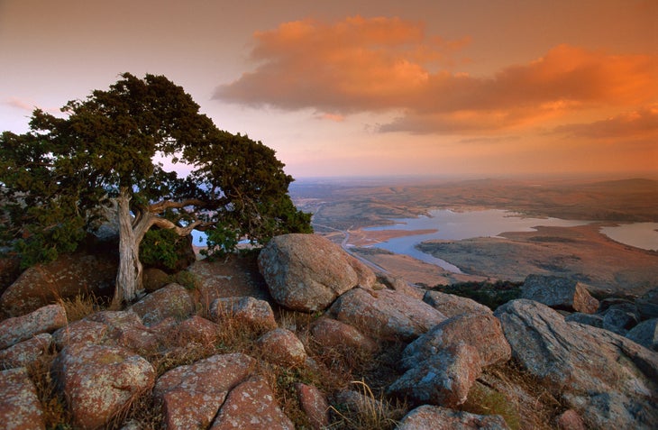
#1 - Charon's Garden Mountains Trail
This trail is a short hike that captures much of Oklahoma’s natural beauty. Oklahoma does not have much elevation, as indicated by this hike, which only gains 614 feet across the 5.8 miles of this out-and-back trail. You will need a permit for this adventure that features many unique boulder formations. About a mile into the hike, a side trail takes you to the Post Oak Waterfall, which is a welcome break from the heat and rocks. Later on, the crux of the trail will take you over a boulder field where you will need to scramble and climb. This isn’t your mother’s playground; watch out for rattlesnakes!
The dry terrain has its own majestic beauty. If you are lucky, you may see wild buffalo, elk, whitetail deer, or rabbits. Oklahoma is known for its role in bison preservation: it was the first state to found a national preserve, which is now called the Wichita Mountains National Wildlife Reserve.
#2 - Ankle Express Trail
On the other side of the state, the Ankle Express Trail awaits your boots in the Greenleaf State Park. It features quirky adventures such as a swinging bridge. The trail will challenge you physically as well. Even though it only has 500 feet gained throughout the course of the twelve-mile loop, some sections are still at a steep enough uphill to offer a respiratory challenge to even the most accomplished hiker.
And the best part? This hike does not require a permit and camping at Mary’s Cove Campground and North Primitive Campground is absolutely free. The low-budget nature of this hike makes it a great option for a weekend get-away without digging too deep in your pockets.

#3 - Robbers Cave State Park
As if backpacking was not pleasantly archaic enough—the honing down of possessions to only the necessary items, the communing with nature, the isolation from civilization and technology—this park brings the added romance of being the hide-out of Jesse James and the Bandit Queen Belle Starr. You can hike the same trails that they used to escape the law!
Primitive camping trails line the edge of this state park. You can make a base camp there and hike out each day with a smaller day pack. This park not only features plenty of caves to hide even your most grievous transgressions, but also three refreshing lakes.
Who knows? You might even find buried treasure.
#4 - Winding Stair Mountain Loop
Speaking of history, let’s visit the other side of the American narrative: the Indian Nation trail. You will walk the Indian Nation trail, which is a path used by Native Americans in times gone by, for the last bit of this 22-mile loop.
This loop does not only take you back in time, but also up and down. It is a compilation of the Boardstand Trail, Old Military Road, the Ouchita, and the Nation Indian trail. Across this unique combination of trails, it goes through valleys, creeks, and, of course, mountains. The namesake, Winding Stair Mountain, makes an early appearance and is followed by the Chancellor Mountains.
As with almost all of these hikes, there are several water sources, but the creeks are often dry in the later summer months. To ensure that you will have enough water (dehydration is a tremendous threat in the hot Oklahoma summers), plan ahead to carry your water or be certain that the water sources will be plentiful .
#5 - Horse Thief Spring Trail
While you’re out in the way of the Ouchita Mountains, check out this quintessential Oklahoma backpacking trail. It is a 14-mile loop and features a lake. You can bring your furry friends on this hike, which makes the beautiful scenery all the more joyful.
This trail is free and only sees moderate use. It would be a great opportunity to escape some of the white noise and listen to the leaves whispering. As you hike, you can imagine what the horse thieves that used this trail were thinking as they led their illegal bounty through the trees.

#6 - Beaver's Bend State Park
The beauty of this trail is that it has thirty miles of potential hiking adventure…yes, it’s true, a trail this long can keep you and your companions in the backcountry for more than just the weekend. Are you looking for an escape for almost a whole week? Then this is the trail for you!
This trail is also an escape from the heat of the other trails. Many of the other trails feature intense heat and dry creek beds, but this one has gigantic trees with beautiful dappled shady creeks burbling through the trails.
The crown jewel of this state park is the David Boren Hiking Trail. David Boren was a former governor of The Sooner State. This conglomerate trail features no less than seven other trails, including the Beavercreek Trail, the Skyline Trail, and the Lookout Mountain Trail.
If you finish this adventure and decide that you are still hungry for more outdoor frolicking, this state park does offer options for mountain biking. Whether you’re taking to the trees on two wheels or two feet, Beaver’s Bend State Park offers serenity and exploration.
#7 - McGee Creek Natural Scenic Recreation Area Loop
The great variety of natural scenery available across the entire state of Oklahoma is encapsulated by this hike, and you couldn’t have a list of the best backpacking trails without it. You will see creeks, rock formations like in the Charon’s Garden Mountain Trail, canyons, and beautiful overlooks like at the Winding Stair Mountain Loop. The area around this loop offers over 25 miles of trails, which opens up a limitless amount of routes from which you can fabricate your perfect weekend adventure.
As a perk, this route is free. You will have to register at the trail head, but otherwise this affordable venture is a wonderful option if you live nearby. You could visit the park for several weekends in a row and still see something new every time. For example, on the main loop, you will encounter such canyons as Little Bugaboo, Bugaboo, and Wildcat.
Pro tip: check out this trail in the spring or fall. In the spring, the wilderness will be blooming into virility, and in the fall the changing color of the leaves will leave you in awe of nature’s palette.
7 of the Best Backpacking Trails in Oklahoma - Conclusion
As far as diversity of scenery, interactions with history, and opportunities to view America’s most iconic wildlife, this state beats out all of the competition. While we consider these to be the 7 best backpacking trails that Oklahoma has to offer, there are many more gems to be found if you’re willing to go off the beaten path. It is for these reasons we recommend you visit “The Sooner State” sooner rather than later. If you’re looking for more potential destinations, check out our articles “ Hiking Trails in Gatlinburg TN with Waterfalls ” as well as “ 5 of the Best Adirondacks Backpacking Loops “. Happy traveling!
Tags: backpacking camping hiking
You may also like...

Scariest and Most Dangerous Hikes in America

4 of the Best Sequoia National Park Backpacking Loops

Top 5 Wind River Range Backpacking Loops
- Next story Scariest and Most Dangerous Hikes in America
- Previous story Hiking Trails in Gatlinburg TN with Waterfalls
Site Search
Suggested posts.
Best Rainforest Hikes in Olympic National Park
Best Section Hikes on the Appalachian Trail
How to Bear Proof Your Campsite for Camping Safety
Best Selling Products
CURRENT PRICES END MAY 12
Outside Festival feat. Thundercat and Fleet Foxes.
GET TICKETS
Start Your Free Trial
Powered by Outside
No, Seriously—Go Hiking in Oklahoma
With both "eastern-style" and "western-style" mountains, oklahoma is a little-known hiker paradise..
Heading out the door? Read this article on the new Outside+ app available now on iOS devices for members! >","name":"in-content-cta","type":"link"}}'>Download the app .
It was a last-second decision to load a daypack into my ancient Toyota 4Runner. You know—just in case. Business completely unrelated to walking through the woods had steered me to Oklahoma, a state that—how to say this tactfully?—does not normally register on the radar of most hiking aficionados.
But as I came to learn by way of some simple detours, Oklahoma offers a wide variety of hiking opportunities . It is the only state I’ve visited that boasts “Western-type” mountains and “Eastern-type” mountains. The former offer long-distance vistas, arid, cactus-covered landscapes, and roaming bison herds, while the latter are home to dense hardwood forests, pristine rivers, and numerous lakes. Best of all, both offer public land latticed with trails perfect for shouldering a pack (like the one I had slipped into my car). And with just a few hours of driving, you can experience both on the same trip.
This newfound knowledge is a godsend for a man who, because of work and family obligations, often finds himself driving—usually at an intemperate rate of speed—across the often-featureless Great Plains in hopes of reaching higher ground before dozing off behind the wheel. Sure, these peaks are a bit off the beaten path, but that’s a big part of the allure.
Part One: Western-type mountains
My first stop was in Lawton, where a soldier from nearby Ft. Sill who I met in a bar directed me toward the Wichita Mountains National Wildlife Refuge (WMNWR), about which I knew nada. I expected little more than a cursory drive while eyeballing whatever wildlife might call the refuge home.
The Wichita Mountains consist mostly of eroded granite some 500 million years old. The 59,000-acre WMNWR was established in 1901 as a federal forest reserve. In 1936, the U.S. Forest Service transferred it to the Bureau of Fisheries and the Bureau of Biological Survey, precursors of the U.S. Fish and Wildlife Service. It is considered the oldest managed wildlife facility in the USFWS system.
According to environmental education specialist Randy Hale, visitors know the refuge for three things: wildlife viewing, hiking, and rock climbing.
“We have 550 bison, more than 1,000 elk, and a herd of 100 longhorn cattle that is maintained to preserve the cultural and historical legacy of this breed,” says Hale, who grew up in the area and has worked at the refuge for more than 30 years. “We also have more than 200 species of birds.”
The refuge is home to about 22 miles of marked trails, with a couple vertical gains exceeding 1,000 feet. Off-trail hiking is allowed, too, though two-thirds of the refuge—including the area’s highest point, 2,476-foot Mt. Pinchot— is a special-use area that’s off-limits to visitors. (“Wildlife needs a place where they can take a break,” as Hale notes.)
After a night spent at Doris Campground—where, during a late-spring visit, I was the only guest—I drove to the parking lot for the 1.1-mile Elk Mountain Trail and set out in search of a good bushwhacking route. I passed through a convoluted labyrinth of house-sized granite boulders and rock spires, which made routefinding more difficult than I had anticipated.
To the north, herds of bison—first introduced in 1905—roamed across the grasslands. To the south, the pink-and-tan rock formations reminded me of New Mexico’s City of Rocks State Park, but much more varied and expansive.
Finding this grandeur in what is essentially the middle of the Great Plains was disorienting. I thought of the lakes, streams, and slot canyons Hale had told me about, hidden somewhere in that scenery . But alas, tight scheduling demanded I move on. After a few hours wandering through what amounted to a geologic maze, I turned around and started back to the trailhead.
Part Two: Eastern-type mountains
During my pre-trip map perusal, I had noticed a stretch of blacktop called the Talimena National Scenic Byway , which traverses a part of the Ouachita National Forest (ONF) between Oklahoma’s Talimena State Park and the town of Mena, Arkansas. When I arrived early enough on a Sunday morning, traffic was almost nonexistent, everyone else in this particular part of the Bible Belt apparently being otherwise occupied. The byway, which the Civilian Conservation Corps constructed in the 1930s, follows the crest of Winding Stair Mountain in a seemingly endless series of curves and undulations with grades that often exceed 13 percent. It was like driving on a roller coaster, but with more than 20 designated scenic overlooks along the way.
Twenty-seven miles in, a sign advised me that I was crossing the 223-mile Ouachita National Recreation Trail . I pulled into the Winding Stair Trailhead, happily hoisted my pack, and hiked a couple sweaty miles up a steep hill. I was surprised, first, to come across an Appalachian Trail-style shelter (named Winding Stair) and, second, to observe thickly forested ridges that were more reminiscent of the Blue Ridge or the Poconos than what I would have expected to find in the Sooner State, especially after having recently visited the arid WMNWR. This section of the Ouachita National Forest offers vertical relief that approaches 1,500 feet. With precipitous drop-offs, jungle-like vegetation, and shockingly rocky terrain, bushwhacking was out of the question.
The Ouachita is the oldest and largest national forest in the south, covering 1.8 million acres, most of which are in Arkansas. But more than 363,000 of those acres—an area larger than Rocky Mountain National Park—lie in Oklahoma.
According to Chris Ham, recreation, planning, heritage and wilderness staff officer for the ONF, the shale and sandstone dominated Ouachita Mountains are a geologic rarity in that they generally run east-west. As such, two distinct biomes exist there: The moist, north-facing slopes are home to dense southern hardwood forests, whereas pine and oak dominate the drier south-facing slopes. More than 60 species of trees and more than 200 species of birds dwell in the ONF. There are bears, mountain lions, a viable population of red wolves, and, as Ham casually dropped into our conversation, “the northernmost population of American alligators.”
“One of my favorite things is the abundance of water,” says Matt Edwards, Oklahoma captain for the Friends of the Ouachita Trail, who has hiked the entire path. ( The Friends of the Ouachita Trail estimate that as many as 1,000 people have thru-hiked the OT in the past three years.) “Hiking along the nearby waterways, like Big Cedar Creek, is wonderful, and you are unlikely to run into anyone else. The water here is some of the clearest and cleanest in the country.”
According to Edwards, a 42-mile section of the OT in Oklahoma has five trail shelters. It passes through the 9,700-acre Upper Kiamichi River Wilderness, and there’s a spur trail to the 13,000-acre Black Fork Mountain Wilderness.
“There’s a lot of country to explore,” Edwards adds.
While sitting in the Winding Stair shelter, I found myself wondering what other surprises might be found farther along the OT as it snakes through a verdant, surprisingly rugged corner of the country that I had never before given a second’s thought.
A return trip is clearly in order. Maybe I’ll go searching for some of those alligators Ham mentioned.
Oklahoma Hiking 101
Wichita mountains national wildlife refuge.
Ancestral home of the Kitikiti’sh
Location: North of Lawton, Oklahoma
Hiking: 22 miles of marked system trails, the longest of which is the 6-mile Bison Trail. Off trail hiking is allowed.
Camping: Doris Campground has 66 sites, many of which offer electricity. There is also a campground in the 5,700-acre Charon’s Gardens Wilderness Area , located in the westernmost part of the refuge. Reservations are required and visitation is limited to 10 campers per night.
Climbing: The Wichita Mountains offer a plethora of rock climbing opportunities. According to the Wichita Mountains Climbers Coalition website , the WMNWR is home to hundreds of quality trad and sport routes.
Need to know: Two-thirds of the WMNWF is a special use area closed off to most human visitation. The WMNWF is adjacent to the 94,000-acre Fort Sill army base, home to the Field Artillery Training Command. Consequently, it is not unusual to have your backcountry quietude interrupted by the sound of cannons firing. There are numerous varieties of venomous snakes residing in the WMNWR, including water moccasins, copperheads, and at least four species of rattlesnakes. Weekends can be very crowded. Daily high temperatures in July and August average 95 degrees, but can easily exceed 100.
Oklahoma Ranger District, Ouachita National Forest
Ancestral home of the Ouachita
Location: Southeastern Oklahoma, between the village of Talihina and the Arkansas border
Hiking: Many miles of trails, including a 42-mile section of the Ouachita Trail . Also popular is the 23-mile Boardstand Road & Old Military Road loop, 14 miles of trail in the Cedar Lake area and 80 miles of multi-use equestrian trail.
Camping: There are USFS campgrounds at Billy Creek Recreation Area , Cedar Lake, and near Winding Stair Trailhead , the latter of which is divided into two segments, one for RV-type camping and the other for backpackers. There are five primitive trail shelters along the Ouachita Trail in Oklahoma. Dispersed camping is allowed.
Need to know: It is not recommended to visit this area in the summer, when extreme temperatures, ticks, chiggers, and poison ivy will make any hike miserable. Fall colors are spectacular. Like the WMNWR, there are numerous varieties of venomous snakes in the Ouachita National Forest, including copperheads, water moccasins, and several species of rattlers.
Popular on Backpacker
Related content from the outside network, what’s it like to go on a 200-person hike better than you think., how to pack for backcountry skiing, the original yosemite firefall, hiker charges mountain lion.
where you WANDER
- - - - , - - - - .
- Jan 30, 2022
- 14 min read
A Detailed Guide To Oklahoma's Hiking Trails
Updated: Apr 16

Oklahoma doesn't have the extremely elevated mountain peaks found in states like Colorado, Wyoming and Utah, but you might be surprised by how enjoyable its hiking trails can be. And, there are likely more than you thought, spread all across the state.
Nearly all of these trails (and their parks) bring something new to a day of hiking. Some take you into the woods, and others send you into the sun. Some give you beautiful views, and others provide you the chance to get close to wildlife. Many of them have bodies of water nearby, from lakes to natural springs. And a lot of them have extra things to do to extend your day in the outdoors.
Use this hiking guide to discover which trails might be more your speed (or distance, rather), and get the inside scoop on which ones I like the best.
*I'll continue updating this list as I visit more nature hiking trails in The Sooner State.
What You'll Find In This Post:
Gloss Mountain State Park
Turner Falls Park
Roman Nose State Park
Greenleaf State Park
Quartz Mountain State Park
Wichita Mountains Wildlife Refuge
In a rush? Pin this post for later!

GLOSS MOUNTAIN STATE PARK
Cathedral Mountain Trail | Location: Fairview, OK
Difficulty: Easy
Length: 1.5-mile loop
Elevation Gain: 206 ft
About The Hike » It's almost incorrect really to call the Cathedral Mountain Trail a hike since it's only 1.5 miles in total — if that. There is a fairly steep incline at the beginning with a railing, and from there, you're basically on a plateau, so it's an easy route. The plateau is not extremely high, but anyone who is afraid of heights likely wouldn't love this trail.
What You'll See » While the hike isn't impressive, the park is a beautiful sight. Firstly, the red dirt/clay (really, it is port) found in Oklahoma is very prevalent, so the plateaus that you'll see are unique in that. The red surroundings make for some great photos! Additionally, the Gloss Mountains are also sometimes called the Glass Mountains due to the high Selenite content, a type of quartz, which looks like shiny glass. So along your walk, you'll see a lot of sparkles! Lastly, the other cool aspect of this trail is that there are a few plaques along the way explaining the terrain as well as what you're viewing in the distance, such as the names of the bodies of water around you.
Know Before You Go »
Visitor's Center: None
Admission: FREE
Parking: The parking lot is located right at the base of the plateau and beginning of the trail, and it's FREE.
Bathrooms: YES. There are bathrooms in the parking lot.
Camping: While there is no camping in the park, there are some campsites nearby through Gloss Mountain Outfitters, though it's nearly a 30-mile drive.
Food: None. However, there are towns near the park where you can stop to get a bite to eat.
Cell Service: You'll likely have normal service here.
Website: www.travelok.com/state-parks/gloss-mountain-state-park
My Opinion »
If you're heading to a town that's near this area or driving that route through to Kansas, hiking here would be a fun thing to do to stretch your legs on the way. However, Gloss Mountain State Park by itself isn't really worth a 2-hour drive there and a 2-hour drive back, so if that's your main activity for the day, see if you can find something else to pair it with. For example, on the way back to OKC, I stopped at the Frank Raab Nature Trail in Canton.

TURNER FALLS PARK
Turner Falls Park Hiking Trails | Location: Davis, OK
Difficulty: Easy/Moderate
Length: 3.5-mile loop
Elevation Gain: 344 ft
About The Hike » Turner Falls Park is located in the Arbuckle Mountains, is the oldest park in Oklahoma and consists of 1,500 acres. There is just one trail that basically runs from the highest point down through the recreational areas and back up. One portion of it is very clear with a dirt path. Another portion runs through the forest and doesn't show up quite as clearly, especially since it intersects campsites and the main road. Any signs that might have been there for visitors are not helpful anymore, so I suggest using AllTrails to find your way, though some users say the map is incorrect there as well. While the hike isn't very difficult as a whole, the path down to the waterfall is steep and tricky, so watch your step!
What You'll See » Although it might sound funny, the first thing to note is that you'll see a lot of people at this park. It's a hot spot for families in the summer due to the 77-ft waterfall (Oklahoma's largest waterfall) that drops into a natural swimming pool. The waterfall and pool are a part of Honey Creek, which is spring-fed and travels through the Arbuckle Mountains. The recreational area also includes some caves and the ruins of Collings Castle, which was built in the 1930s, that you can explore. If you walk up the stairs at the castle and up the steep ramp that follows, you'll find an overlook of the waterfall area, a perfect place to snap a photo.
Visitor's Center: I didn't see a visitor's center or office (there could be one!), but you'll run into workers or rangers who might be able to answer your questions/assist you if needed.
Admission: The entrance fee varies depending on the time of the year and whether you're visiting on a weekday or a weekend. For example, admission is higher from May through September than October through April because it's warm enough to swim, the most popular activity. Weekends are also more expensive than weekdays. For instance, on a Monday it's $16 for adults, but on a weekend, it's $20. Children are cheaper or free, depending on their ages, and seniors and active duty military get discounts. See the park's admission page for details.
Parking: There are levels of parking, with each a different price. For example, Level 1 Parking is closest to the waterfall and is $20 for the day. Level 2 Parking is further away (and at a higher elevation) and costs $10. Level 3 Parking is even further away but is free. If you plan on doing the hike, then I highly recommend Level 3 since you can park at the higher point of elevation, the "beginning" of the trail loop is near you, and you can walk down to the waterfall, spend the day there and then hike back up to your vehicle.
Bathrooms: YES. They are located at the waterfall.
Camping: YES. Camping is a popular activity at this park. There are also RV sites, shelters and cabins. Be sure to reserve your spot in advance!
Food: YES. There are snack bars that offer hamburgers, hotdogs, nachos, etc. Arbuckle Fried Pies is also just about a mile from the park. Depending on which direction you come from, you'll pass it on your drive there.
Cell Service: Likely none.
Website: www.turnerfallspark.com/
Despite the trail not being spectacular, due to parts of it being hard to follow and trashy from the campsites, pairing the hike with the other activities in this park creates a fun spot to spend a summer day. So, I suggest you make the most of everything! Walk down to the waterfall, find a cave along the way, visit the castle ruins, swim to cool yourself off and then hike the other side of the loop back up to your car.

ROMAN NOSE STATE PARK
Inspiration Point Loop, Canyon Loop, Natural Springs Trail | Location: Watonga, OK
Difficulty: Moderate
Length: more than 6.8 miles of trail
Elevation Gain: 518 feet (when hiking the trail with the highest point)
About The Hike » I'm rating this trail "moderate," as there are consistent elevation changes — you'll go up and down a lot. So, despite the elevation not being drastic, if you do the full Inspiration Loop, it will tire you out. The paths here are fairly open and easy to follow. I even saw a biker using it when I visited. And keep in mind that the trail doesn't take you out very far into the park. It mostly keeps your hike contained to one area and then crisscrosses and loops around to make good use of the space.
What You'll See » There isn't a lot to "view" here, but the trees are a pretty sight as you walk since most of them are junipers with blue fruits that look like berries. At the highest point (follow the Inspiration Point loop to get there), you'll get an overview of the park and its lakes. And before you get to the Inspiration Point Loop, you'll be able to read some plaques about nature, cross a wooden bridge and see a natural spring, which one of the signs will point out. Apparently, the Natural Springs Trail, which is in another area of the park, includes a hidden waterfall, natural springs and wading spots. It's definitely something I'll have to check out the next time I visit!
Visitor's Center: According to the park's map, the office is located in the golf pro shop just past the "Roman Nose State Park" sign. But if you ever have any questions, I'm sure they can also be answered at the lodge/restaurant and the grocery store/bait shop.
Parking: It's FREE, and there are basically two entrances to the trails, so there are two places you can park. The first lot is at the lodge with the trailhead near the dumpster area, and the second is at the Roman Nose General Store where you walk on a path between Boecher Lake and Watonga Lake to get to the trail.
Bathrooms: YES. You can find (nice) bathrooms at the lodge/restaurant and also likely at the other buildings and throughout the park.
Camping: YES. There are campsites and cabins. Additionally, the Roman Nose Resort offers lodge rooms, and The Fairway Cottage can accommodate 10 guests.
Food: YES. Swadley's Foggy Bottom Kitchen, located in the lodge, is available to visitors, but keep in mind that it's closed on Sundays, Mondays and Tuesdays.
Cell Service: I had service, but other hikers I met along the way did not.
Website: www.travelok.com/state-parks/roman-nose-state-park
It's a good place to get your workout in while enjoying nature. The trees create a peaceful beauty here and help you feel as though you've really gotten away from the world for a while. I didn't have time to visit the natural springs, so I'll definitely be going back! And despite the slight elevation, this is also a trail I'll bring friends to who aren't super into hiking but want to walk and spend the day outside in nature.

GREENLEAF STATE PARK
Greenleaf Trail (Lower, Middle and Upper Segments) | Location: Braggs, OK
Length: 18.8 miles of trail
Elevation Gain: 1,896 ft at most
About The Hike » The very first portion of the hike makes for a pleasant walk through the woods and includes a few signs with nature facts. To get to the rest of the trails (and the swinging bridge), keep in mind that you do have to walk on a portion of the highway that crosses the lake. There is enough room on the shoulder so that you don't really have to be nervous, but be careful if you have children with you. Past the bridge, I was also lucky that there were so many blue and orange markers on the trees to follow because the actual path wasn't clear all the time and was pretty thorny. I often found myself walking wherever it was easiest until I saw more blue signs, which makes me wonder how easy it would be to follow it when it's not winter and the trees have leaves. Overall, with the length of the trail (obviously, it's your choice how far you go) and the elevation in the middle and upper segments, I would say the difficulty of this hike is moderate.
What You'll See » There are basically three things that made this park and its trail interesting for me. The first is that the lower segment of the trail (the first half) takes you around the lake. Being someone who loves water, I enjoyed seeing it glisten through the trees. The second is the bridge, which EVERYBODY goes to Greenleaf State Park to see. The swinging bridge separates the lower segment from the middle and upper segments of the trail and takes you across a narrow portion of the lake. No worries! It doesn't swing THAT much, but it's a good spot to enjoy a view as well as take photos. The final aspect of the hike that I liked was this small, bright blue pool I found. I'm not sure if it always looks like a pool or if it only does in the winter months because there is less water flowing, but it was magical! To get to it, take the first trail to the right as soon as you pass the swinging bridge. (I believe the park calls this the South Loop.) Follow it up until you reach the first major curve where it looks like a stream typically passes through. And be careful, it's slick!
Visitor's Center: YES. It's small but has a bathroom, maps and a gift shop. (P.S., ask the nice ladies at the counters if you have any questions!)
Admission: FREE ... other than parking (see below).
Parking: It's $10 for one day. You can pay via a machine at the visitor's office or online.
Bathrooms: YES. Bathrooms can be found at the visitor's center or in various locations (campsites) around the park — there won't be any on the hiking trail.
Camping: YES. The park has tent campsites, RV campsites and cabins you can book for different fees.
Food: None. You won't find any food within the park, but the town of Braggs isn't far away and has a few options as well as a gas station.
Cell Service: It's limited. I n some areas, I couldn't get anything, and in others (past the bridge), I got signal off and on.
Website: www.travelok.com/state-parks/greenleaf-state-park
While I can't speak about what this hike is like during the other seasons, Greenleaf State Park is a great place to visit when there is nice weather in the winter. It's still beautiful, and it's easier to see the trail. Plus, you've got to walk the bridge and see the blue pool at least once! Although I likely won't go back to the park again specifically to hike now that I've been, I will definitely try out more portions of the trail segments if I go back to camp or fish.

QUARTZ MOUNTAIN STATE PARK
Heart Healthy Trail, Twin Peaks Trail, Cedar Valley Trail, Mesquite Forest Trail, Tom Creider Cave Trail, Sunrise Trail, New Horizon Trail, Baldy Point, Mountain Pass Trail | Location: Lone Wolf, OK
Length: about 7 miles of trail
Elevation Gain: 341 ft
About The Hike » None of the trails are very long at this state park, and most of them don't loop. In fact, the longest is 1.8 miles one way, and that's the paved running trail. The hikes don't include much elevation either. So simply think of this park as having some enjoyable nature trails in which you can partake in shaded or sunny walks on pavement, dirt and sometimes sand. A few of the paths do include rocks, and during the hot months, rattlesnakes like to hang out there. For this reason, I suggest you wear actual hiking boots.
What You'll See » This is a popular park for rock climbers, so you might see quite a few people at the campsites or at the bottom of an elevated rock formation for this reason. Mountain biking, ATV riding and disc golfing are a few other pastime possibilities. Wildlife can be a common sight. Rattlesnakes and lizards like the warm rocks, and there are plenty of the usual forest-living animals like squirrels and birds. As far as the landscape goes, you'll get to enjoy those Oklahoman orange-ish rock formations along with lush greenery in the spring that make you feel like you've been transported to New Zealand for a moment. Lake Altus also provides beautiful views due to its bright blue coloring and little inlets and islands. Consider spending some time on its beaches or in the water itself swimming or boating.
Know Before You Go »
Visitor's Center: YES, there is a visitor's center at this park. It has bathrooms and a gift shop. This is also the place to ask questions about the park, pay for camping passes, grab a map and a free tote bag!
Admission: FREE (other than parking)
Parking: You do have to pay to park. I believe it cost us about $7 for a day pass for parking, but you can extend it past a day as well.
Bathrooms: YES. You can go to the restroom at the visitors center, the lodge and other portable toilets near some of the trailheads.
Camping: YES. Camping is a popular activity at this park. There are also RV sites, cabins and the big lodge, which looks to be a really nice place to stay.
Food: YES. There are is a restaurant called The Lookout Kitchen inside the lodge. It serves breakfast, lunch and dinner to visitors and guests.
Cell Service: Surprisingly, I was able to call and text just fine!
Website: www.travelok.com/state-parks/quartz-mountain-state-park
My Opinion »
I was pleasantly surprised by the beauty of this park, specifically in the spring. In fact, I plan to come back here to kayak Lake Altus at some point. The lodge was another surprising spot, as it's one of the nicest park buildings I've seen in Oklahoma so far (though I didn't look in the rooms). I will say that I wouldn't come back here during the summer to hike, however, as I'm not a fan of snakes, and there were a lot of rattlesnakes with the incoming heat.

WICHITA MOUNTAINS WILDLIFE REFUGE
Mount Scott, Dog Run Hollow Trail System, Charons Garden Wilderness Area | Location: Comanche County
Difficulty: Easy, Moderate and Difficult
Length: 15 miles of trail
Elevation Gain: 1,026 ft at most
* For more information about the Wichita Mountains Wildlife Refuge than what you read here, check out this blog post , which will give you additional details about its hikes as well as some tips to remember before you go!
About The Hike » Just about whatever kind of hiking you're into can be found at the Wichita Mountains Wildlife Refuge. Mount Scott, for example, is 2,464 ft above sea level and is very steep. Visitors can walk up (on the concrete road) or drive up. The gate doesn't open up for cars until later in the morning, so I suggest hiking it before then so you don't have to deal with passing vehicles. The trails in the C haron's Garden Wilderness Area are also fairly steep and, in my opinion, more difficult since they take you through nature rather than on a road. The Dog Run Hollow System, on the other hand, includes mostly non-incline trails and is easy, as far as difficulty goes.
What You'll See » There are so many exciting things to see in this park, namely, the wildlife. Prairie dogs pop in and out of their holes on the side of the roads, and bison and longhorns roam the refuge. Obviously, you'll want to be careful around them, but many people hike in the Wichita Mountains, so there's no need to be worried when you see the animals. The views when you reach the various summits are also majestic, especially on Mount Scott, as shown in the photo above. And if you're interested, you'll also find The Holy City of the Wichitas at the refuge, which is a replica of notable Biblical structures in Jerusalem during Jesus' time. It's home to the longest-running annual Easter Passion Play.
Visitor's Center: YES, there is a visitor's center at the refuge. Not only does it have bathrooms and water, but you'll also find a small exhibit about Oklahoma wildlife and a gift shop.
Parking: There is FREE parking at each trail or activity. (Visitors have to park on the road's shoulder to climb Mount Scott if the gate isn't open.)
Bathrooms: Yes. You'll find bathrooms at the visitor's center (I assume), The Holy City of the Wichitas and some of the trailheads.
Camping: YES. The Doris Campground is a modern camping facility for groups, but you can also backcountry camp in the Charon's Garden Wilderness Area. All campers must reserve their spots.
Food: None. However, the towns of Lawton and Cache are near enough to grab a bite if you're hungry.
Cell Service: None. This is definitely an area in which you need a printed-out or downloaded map. If the Visitor's Center is open, I'm sure you'll be able to snag one there, but I suggest finding the map online before you go. It will be a lifesaver as you traverse the roads and look for specific trails and parking.
Website: www.fws.gov/refuge/wichita-mountains
This is my favorite place to hike in Oklahoma so far! It has all types of trails, and a lot of them, so it makes for a well-rounded day. This refuge also has a higher elevation for hiking than most other areas in Oklahoma, so it's good practice for anyone wanting to increase their stamina. I haven't done all of the trails yet, but I plan to go back, especially because the wildlife is just about everywhere you turn!
- The Great Outdoors
- United States
Related Posts
Tips For Hiking The Wichita Mountains Wildlife Refuge
12 Free Things To Do In Oklahoma City
Best Restaurants In Oklahoma City (By Category)
Join our Adventure: Get all my insider tips for traveling to the coolest places on earth
- Beautiful Backpacking Trails in Oklahoma
Sharing is caring!
We love traveling all over, and roaming the planet but you can’t go on far off destinations for long vacations all the time. We do however, get to get away for a few days quite often and that usually means discovering hidden gems right in our own backyard or right next to it. We love finding new places to visit and think it is a good idea to do our research before heading out. If we can take the pups with us and do most of what we want to do that is a bonus because then we don’t have to have someone house/dogsit for us and it gives us more flexibility in our schedule as to when we can go and how long we can stay. So grab your favorite hiking shoes and check out these backpacking trails in Oklahoma.

Our little camper also gives us some freedom since we aren’t tent campers any more, we don’t always need to find a pet friendly hotel or Air BNB. We can head out and find a new trail and a parking area for the camper and we are good to go. We love finding sites with RV hookups and picnic tables but we don’t always have to be limited by those. I hope that you head out and enjoy some backpacking trails in Oklahoma even if you are only able to make a day of it. Just because you can’t tent camp or take a week off of work doesn’t mean you can’t enjoy the days you do have right close to home . If you are reading this and you are in another state I encourage you to find hidden gems just like these close to you, and maybe when you do have some days off you can make the trek all the way to Oklahoma to come explore some of our favorite places.
Feel free to use the comment section at the bottom to tell us your favorite destination for backpacking trails in Oklahoma or where you are. Oklahoma is a state full of surprises, and that includes its hiking trails. From easy day hikes to multi-day backpacking trips for the experienced hiker, there’s something for everyone in the Sooner State. In this blog post, we’ll also take a look at five of the best backpacking trails in Oklahoma. I’m so glad that many are not too far from Oklahoma City and have picnic areas making for a great day trip destination . So get your hiking boots ready and start making your list of fun hikes.
What is the longest hiking trail in Oklahoma?
The Ouachita National Recreation Trail is the longest hiking trail in Oklahoma and it one of the best hikes in the state. It runs for Ouachita Mountains from Talimena State Park in southeastern Oklahoma to Pinnacle Mountain State Park in central Arkansas. The Ouachita National Recreation Trail is over two hundred miles long and follows the scenic Ouachita Mountains. Along the way, hikers can enjoy views of rivers, lakes, and forests. The Ouachita National Recreation Trail is a popular destination for both day hikes and overnight camping trips. Definitely make plans to check out at least part of the Ouachita Trail and the Ouachita National Forest.

What is the Prettiest Place to Hike in Oklahoma?
There are many beautiful places to hike in Oklahoma, but one of the most scenic is the Wichita Mountains Wildlife Refuge . The refuge is home to a diverse array of plant and animal life, and the scenery is truly breathtaking. The miles of trails wind through towering limestone cliffs, crystal-clear creeks, and lush meadows. Whether you’re looking for a challenging hike or a leisurely stroll, the Wichita Mountains Wildlife Refuge has something to offer. And best of all, you can enjoy the stunning views year-round. So if you’re looking for a place to get away from it all and commune with nature, the Wichita Mountains Wildlife Refuge is definitely worth a visit. I will say that so many of the trails we are going to talk about are absolutely amazing though. Sometimes I am amazed to see the higher elevations in Oklahoma with more rugged terrain, but sometimes when you are driving out and the land is nice and flat like you expect Oklahoma to be you can just see so far and take in all of the dense woods, or lakes with their pine trees. So if you can’t get to the Wichita Mountains area soon, have no fear, a beautiful hike is not too far away at all.
The 5 Best Backpacking Trails in Oklahoma
The Bluff Creek Trail near Lake Hefner in Oklahoma City is a great option for those looking for an easy hike. The trailhead is located just off of Highway 77 close to the city center, and the trail itself is only about 1.2 miles long. However, what the Bluff Creek Trail lacks in length it makes up for in scenery. The trail follows along Lake Hefner where you can usually count on it being a few degrees cooler than the rest of the city, making it a great option in the summer. This beautiful urban park has a parking lot just off Meridian, making it easily accessible. It is almost unbelievable how amazing it is over here since you are in the city still. Such a perfect place to visit with the kids for just a morning of afternoon hike and you can take a break in the nice shade that is all around. If you need more ways to entertain the little ones there are several playgrounds around Lake Hefner like the Lion’s park on the east shore and to the south you will find Stars and Stripes park. You can boat and do other water sports at Lake Hefner like paddle boarding and kayaking, but swimming is not allowed in Lake Hefner. This is a great choice for those living right in or near OKC because sometimes you just need a peaceful hike on your day off before brunch or running all of those errands you have to do.

The Black Mesa Peak Trail in northwestern Oklahoma is another great option for those looking for a longer hike. The trailhead is located off Highway 325 near the town of Kenton, and the trail itself is about 16 miles long (8.4 miles one way). Black Mesa Peak is the highest point in Oklahoma at 4,973 feet above sea level, and hikers are rewarded with stunning views from the summit. If you are traveling from the Oklahoma City area, this is one of the farthest drives you will find in the state for a great hike. This trip is great for a camping destination especially if you plan to go with a group of friends. It offers online reservable RV campsites with water and electric hookups, tent campsites, picnic facilities, boat ramps, playground and restrooms with showers. Plan on having a hiking adventure with your family or friends at Black Mesa. I think this destination is ideal if you have at least 4 days to head out into nature. You will spend a good portion of your day driving and then will need to set up camp etc. Give yourself at least 2 days to explore all the trails and things to see here. If you have a telescope that travels well you will want to bring it as the night sky here is so amazing in this remote location.
For those looking for an even more challenging hike, the Winding Stair Mountains National Recreation Area in southeastern Oklahoma is a great option. The trailhead is located just off of Highway 1 and the Talimena Scenic Byway, and the main trail is 4.5 miles. The Winding Stair Mountains are some of the best hiking trails in Oklahoma and worth a visit . There are over 1.7 million acres of fresh air in the Ouachita National Forest, it is the South’s oldest and largest national forest. With a total of 41.5 miles of hiking trails and 19 miles of equestrian trails there is plenty to explore. There has been a reconstruction of 6 miles of hiking trails and 9 miles of equestrian trails. They have also installed interpretive signs at vistas and historic areas on Talimena Scenic Drive so you can really explore and learn about the area. Stop at the visitor center for a detailed map of parking areas, trails and camping areas.

The Wichita Mountains Wildlife Refuge in southwestern Oklahoma is home to multiple hiking trails ranging from easy to moderate in difficulty. The refuge is accessible from multiple highways, and there are several campgrounds located within its boundaries. With miles of hiking trails to choose from, visitors to the Wichita Mountain Wildlife Refuge are sure to find a hike that’s perfect for them. They start out with a tiny .1 mile hike to tour the Environmental Education Center Trail and go up to the narrow trails like the Bison Trail that is 5.48 miles, with over a dozen trails that range somewhere between those. They have plenty of trails that are 1 mile or less that would be great if you have smaller kids or older adults with you that can only handle the easy level trails. A late afternoon hike to explore rock formations and rolling hills is sure to be a crowd pleaser at this popular spot. This park is great for hunting, fishing, backpacking, camping, picnicking, biking, bird watching, boating, climbing, running and wildlife watching, they offer so much more than just a good hike.

Another place we love to visit for the nature trails is Beavers Bend State Park . We love going to this area and getting a cabin because there is so much to see and do here or even finding a great spot to camp . We have several posts on traveling to Broken Bow and Hochatown you can check out here .
For hiking make sure to check in at the Forest Heritage Center and get your map of the trails and check in. They have 5 nature trails that are right at one mile or less and very easy to walk. Then they have some trails for more agile and experienced hikers. If that is more your speed check out the Skyline Trail, but only for the experienced hikers. Though only five miles in length, there are steep climbs and descents, and several creek crossings, so you can get in that workout and really explore nature. You will access the Skyline Trail just across from the Dogwood Campground. Dogs that are leashed are allowed on this trail. We have found so many places to visit in this area we could spend weeks here and would love for you to go check out some of our favorite stops along the way .
Conclusion:
Oklahoma may not be known as a hiking destination, but that doesn’t mean that it doesn’t have plenty to offer hikers of all skill levels. From easy day hikes to multi-day backpacking trips, there’s something for everyone in the Sooner State. So get out there and explore all that Oklahoma has to offer and hit those backpacking trails in Oklahoma!
More Places to Visit in Oklahoma
- Things to Do in Hochatown OK
- Visit the Arbuckle Mountains and Turner Falls Oklahoma
- Your Complete Guide to Camping Robbers Cave
- Camping at Sequoyah National Park Oklahoma
- Great Salt Plains State Park: Your Complete Guide
- 9 Best RV Camping Sites in Oklahoma
FOLLOW US ON SOCIAL MEDIA
- Facebook Group
- Explore Oklahoma Facebook Group
- Hot Deals Group
- Recipe Group
- Homesteading Facebook Group
- Don’t forget to invite your friend’s to our Facebook groups! We would also love to see your vacation pictures!
Similar Posts

Broken Bow Oklahoma Things To Do: What You Need to Know

Free National Park Day – Celebrate National Park Week

The Ultimate Checklist for Camping Supplies

BOILING SPRINGS STATE PARK: WHAT YOU NEED TO KNOW

Things to Do in North Dakota

Best Yosemite Campground – Yosemite National Park Complete Guide
Leave a reply cancel reply.
Your email address will not be published. Required fields are marked *
Save my name, email, and website in this browser for the next time I comment.
This site uses Akismet to reduce spam. Learn how your comment data is processed .

- United States
- Backpacking
Looking for the best backpacking in Oklahoma? We've got you covered with the top trails, trips, hiking, backpacking, camping and more around Oklahoma. The detailed guides, photos, and reviews are all submitted by the Outbound community.
Top Backpacking Spots in and near Oklahoma

Climb at the Wichita Mountains Wildlife Refuge

Backpack the Horsethief Springs Trail
Top activities.
- Photography
- Local Adventures
- Tours and trips
- Camping Nearby
- Outbound PRO Membership
- Add your property
Mobile Apps

© 2024 The Outbound Collective - Terms of Use - Privacy Policy

The 14 best backpacking trails near Oklahoma City
Navigate forward to interact with the calendar and select a date. Press the question mark key to get the keyboard shortcuts for changing dates.
Navigate backward to interact with the calendar and select a date. Press the question mark key to get the keyboard shortcuts for changing dates.

1 Martin Park Nature Center
2 Lake Hefner

3 Stinchcomb Wildlife Refuge
4 myriad botanical gardens, 5 mitch park ymca.

Track your travel spending and split costs with friends
Plan your trip. Keep your budget organized. Split the cost between tripmates. Wanderlog does it all.

6 Arcadia Lake
7 scissortail park, 8 riversport adventures, 9 will rogers gardens, 10 bluff creek park, 11 mat hoffman action sports park, 12 robert s. kerr park, 13 stars and stripes skatepark, 14 oklahoma river, top searches in oklahoma city, popular road trips from oklahoma city, what's the weather like in oklahoma city.
It depends on when you visit! We've compiled data from NASA on what the weather is like in Oklahoma City for each month of the year: see the links below for more information.
- Weather in Oklahoma City in January
- Weather in Oklahoma City in February
- Weather in Oklahoma City in March
- Weather in Oklahoma City in April
- Weather in Oklahoma City in May
- Weather in Oklahoma City in June
- Weather in Oklahoma City in July
- Weather in Oklahoma City in August
- Weather in Oklahoma City in September
- Weather in Oklahoma City in October
- Weather in Oklahoma City in November
- Weather in Oklahoma City in December
All road trips from Oklahoma City
- Oklahoma City to New York City drive
- Oklahoma City to Las Vegas drive
- Oklahoma City to Orlando drive
- Oklahoma City to Chicago drive
- Oklahoma City to Dallas drive
- Oklahoma City to New Orleans drive
- Oklahoma City to Branson drive
- Oklahoma City to San Antonio drive
- Oklahoma City to Washington DC drive
- Oklahoma City to San Francisco drive
- Oklahoma City to Los Angeles drive
- Oklahoma City to Nashville drive
- Oklahoma City to Memphis drive
- Oklahoma City to San Diego drive
- Oklahoma City to Saint Louis drive
- Oklahoma City to Toronto drive
- Oklahoma City to Houston drive
- Oklahoma City to Mexico City drive
- Oklahoma City to Austin drive
- Oklahoma City to Atlanta drive
- Oklahoma City to Fort Worth drive
- Oklahoma City to Kansas City drive
- Oklahoma City to Boston drive
- Oklahoma City to Gatlinburg drive
- Oklahoma City to Niagara Falls drive
- Oklahoma City to Denver drive
- Oklahoma City to Tulsa drive
- Oklahoma City to Santa Fe drive
- Oklahoma City to Colorado Springs drive
- Oklahoma City to Savannah drive
Explore nearby places
- Oklahoma City
- Nichols Hills
- Midwest City
All related maps of Oklahoma City
- Map of Oklahoma City
- Map of Nichols Hills
- Map of Del City
- Map of Warr Acres
- Map of Bethany
- Map of Midwest City
- Map of Moore
- Map of Edmond
- Map of Mustang
- Map of Yukon
- Map of Choctaw
- Map of Jones
- Map of Newcastle
- Map of Piedmont
- Map of Arcadia
- Map of Norman
- Map of Harrah
- Map of Goldsby
- Map of Tuttle
- Map of Luther
- Map of Noble
- Map of Blanchard
- Map of El Reno
- Map of Concho
- Map of Guthrie
- Map of Amber
- Map of Pocasset
- Map of Purcell
- Map of Lexington
- Map of Crescent
- Map of Calumet
Oklahoma City throughout the year
- Oklahoma City in January
- Oklahoma City in February
- Oklahoma City in March
- Oklahoma City in April
- Oklahoma City in May
- Oklahoma City in June
- Oklahoma City in July
- Oklahoma City in August
- Oklahoma City in September
- Oklahoma City in October
- Oklahoma City in November
- Oklahoma City in December
Looking for day-by-day itineraries in Oklahoma City?
Get inspired for your trip to Oklahoma City with our curated itineraries that are jam-packed with popular attractions everyday! Check them out here:
- 1-Day Oklahoma City Itinerary
- 2-Day Oklahoma City Itinerary
- 3-Day Oklahoma City Itinerary
- 4-Day Oklahoma City Itinerary
- 5-Day Oklahoma City Itinerary
Best attractions in nearby cities
- Top things to do and attractions in Norman
- Top things to do and attractions in Edmond
Best restaurants in nearby cities
- Itinerary + map in one view
- Live collaboration
- Auto-import hotels and reservations
- Optimize your route
- Offline access on mobile
- See time and distance between all your places
- North Dakota
- South Dakota
- Exciting Cities
- Food And Drink
- Outdoor Adventures
- Where To Stay
- Skip to right header navigation
- Skip to main content
- Skip to primary sidebar
Learn how to easily plan your dream trip to the Midwest!

15 Best Places for Hiking in Oklahoma
January 19, 2023 by // by Midwest Explored Leave a Comment
There are so many beautiful and diverse trails for hiking in Oklahoma!
When you first think of Oklahoma, you might imagine miles of flat prairies and farmland, but the state has a variety of landscapes to explore.
You will love hiking through mountains and forests as well as along rivers and lakes. Discover waterfalls and caves as you walk the Oklahoma trails.
Whether you want a short and scenic walk or a full-blown workout, there are all sorts of hikes in Oklahoma for all levels.
Let’s take a look at the best places to go hiking in Oklahoma!

Cathedral Mountain Trail
Gloss Mountain State Park near Fairview is a rugged landscape with orange and red colored rock and towering mesas.
The mountains get their name from the selenite in the rock that makes it look shiny. Watch the sky for soaring eagles and the rocks for quick-footed lizards.
If you want to enjoy some epic views, set out on the Cathedral Mountain Trail. This out-and-back trail is about 1.5 miles.
This OK hiking trail is rated moderate to difficult with some steep stairs. The effort is worth it though for the amazing, sweeping views of the mesas and surrounding plains.
Makes sure to bring sun protection because there is very little shade along the trail.

Wichita Mountains Wildlife Refuge Trails
The Wichita Mountains Wildlife Refuge is one of the best places for hiking in Oklahoma! This 60,000-acre refuge is found in the southeast portion of the state.
There are over a dozen trails adding up to about 15 miles. The trails are great places to see wildlife, including bison, prairie dogs, elk, and lizards.
Birdwatchers will love the opportunity to see over 270 species of birds during migration season.
Most of the trails here are under two miles roundtrip and are rated easy. If you want a place for Oklahoma hiking with kids, this is it!
The Elk Mountain Trail is one of the most popular hikes in Oklahoma. It is about 2.3 miles out-and-back and rated moderate.

Beavers Bend State Park Trails
Beavers Bend State Park near Broken Bow has a number of great hiking trails in Oklahoma. You will find views of forests and the waters of Broken Bow Lake and Mountain Fork River.
The moderate Lakeview Lodge Trail is a 3.5-mile loop that partially follows the lake and brings you through pretty woodland.
For a more challenging hike, check out the Skyline Trail. It is a 9.5-mile loop with some steep areas and water crossings. You’ll find amazing views of the river.
When you are done hiking, Beavers Bend State Park offers many other activities such as tennis, volleyball, mini-golf, and camping. Don’t forget to stop by the Forest Heritage Center.
The lake is also popular for boating and scuba diving in the clear water.

Oklahoma River Trail
If you are looking for one of the best trails for biking or hiking in Oklahoma City, then the Oklahoma River Trail is for you!
This paved loop is about 14 miles in total and follows both sides of the Oklahoma River. This is a scenic area for a leisurely walk, a run, or a bike ride.
You’ll make plenty of stops to take photos of the OKC skyline and bridges. Watch the river for waterfowl or people rowing.
While this trail is long, it is flat and easy. You can hike whichever portion you want without taking on the entire thing.
Travertine Creek Trail
In the Chickasaw National Recreation Area outside of Sulphur, you will find the beautiful Travertine Creek Trail.
This 2.8-mile out-and-back trail is a great place to discover waterfalls, find wildflowers, and spot wildlife.
This is an easy, mostly level trail with gravel sections, bridges, and stone stairs. If you want a family-friendly spot for the best hiking in Oklahoma, this is it!
The trail connects the Travertine Nature Center and Pavilion Springs.
There are many other great trails in the Chickasaw National Recreation Area to check out too. Some even lead to some of the coolest springs in Oklahoma!
This park has a history dating back to the early-1900s. It is a beautiful place to explore nature and camp.

Sutton Wilderness Trail
The 160-acre George M. Sutton Wilderness Park in Norman is a lovely park perfect for a day in nature.
The Sutton Wilderness Trail is an easy 1.4-mile loop with nice views of the reservoir and woodland.
Birds, rabbits, deer, lizards, and more can be spotted in the area. In the spring, expect to see wildflowers and butterflies.
The trail is mostly paved or gravel and easily accessible.
Rough Horsetail Nature Trail
Red Rock Canyon Adventure Park is one of the best places for hiking and camping in Oklahoma ! Located near Hinton, this park offers so much to do.
The Rough Horsetail Nature Trail is a 0.6-mile loop rated easy to moderate.
As you walk the trail, admire the vivid colors of the rocks and lush plants. You will be amazed at the power of erosion.
Keep in mind that after it rains the trail can get muddy. Alternatively, if it has been too dry, the trail becomes dusty.
There is also a per-car fee for this park. After hiking, you can swim in the pool or enjoy a picnic.

Black Mesa Summit Trail
If you want to hike to the highest point in Oklahoma, head west to Black Mesa State Park & Nature Preserve at the end of the panhandle.
The viewpoint from 4,973 feet above sea level makes the Black Mesa Summit Trail one of the best things to do in Oklahoma !
The 8.5-mile out-and-back trail is rated moderate to challenging. The first two miles are mostly flat before the 600-foot elevation gain begins.
This outdoor hike is well-marked with diverse flora and fauna, including cacti. Make sure to bring plenty of water and sun protection since there is not much shade.
Once you reach the summit, you will be awed by the panoramic views. On a clear day, you will be able to see New Mexico and Colorado.

Keystone Ancient Forest Trails
The Keystone Ancient Forest near Sand Springs, a small town in Oklahoma , offers some of the best hiking in Oklahoma for nature lovers.
There are a few trails with a mix of difficulty and lengths. There is a trail for everyone here whether you want a longer trek or a short, accessible walk.
As you walk the paths, you will be amazed by the towering 500-year-old cedars and 300-year-old post oak trees.
This is a great place for wildlife viewing. Bring some binoculars and keep an eye out for bald eagles, deer, and even bobcats! Butterflies abound as well.
Lake Hefner Trail For Waterfront Hiking In Oklahoma
The Lake Hefner Trail north of Oklahoma City is a pretty place for a hike along the waterfront. If you love birdwatching while hiking, this lake is a great choice!
The trail is 9.4 miles and loops the entire lake. It is paved and flat, making it an easy place for a walk or bike ride.
Make sure to stop by the 36-foot-tall Lighthouse at East Wharf. It is the perfect place to watch the sunset over the water.
Keep in mind that it can get windy here and there is no shade.
This is one of the best places to hike in Oklahoma if you are looking for something close to the city. It is a convenient place for some exercise.

Roman Nose State Park Trails
Roman Nose State Park is another of the best state parks in Oklahoma for hiking. There is a great system of trails that interconnect so you can make your own route.
If you want a hike with a view, make sure to head up to Inspiration Point. Mountain biking and horseback riding are also options.
You will see Lake Watonga, canyons, natural springs, and mesas.
When you are not hiking, the park offers many other things to do including camping, swimming, canoeing, and golfing.
This is one of the coolest things to do in the Midwest!

Robbers Cave Trail For Interesting Hiking In Oklahoma
If you want to explore an OK hiking trail tied to an interesting legend, then you will love visiting Robbers Cave State Park.
The 0.6-mile Robbers Cave Trail is a loop full of cool rock formations, cliffs, and vast views of the surrounding forest.
Make sure to wear sturdy shoes since this moderate trail is very rocky with some stone steps. It is all worth it when you reach the infamous Robbers Cave.
This cave was allegedly once used as a hideout by Civil War deserters and outlaws. Today, it is a fun place to explore.
Along with the best hiking in Oklahoma, rock climbing is popular in this park as well as camping, canoeing, and biking.

Martin Park Nature Center Trails Has Some Of The Best Hiking In Oklahoma
The Martin Park Nature Center north of Oklahoma City is a 140-acre park perfect for some outdoor recreation.
There are about 2.5 miles of trails here where you can explore and look for wildlife. The trails are easy and short, perfect for the whole family.
If you are looking for one of the best accessible hiking trails in Oklahoma, the Jim Thorpe Rehabilitation Courage Trail is ideal for anyone in a wheelchair or with mobility limitations.
The trail is a wide boardwalk featuring a wheelchair-accessible tree house and touch-based signs and exhibits for the visually impaired.
As you traverse the trails, you will find ponds, waterfalls, wildflowers, and an assortment of wildlife.
Along with the trails, the park has a picnic pavilion, a nature-themed playground, and a visitor’s center where you can learn about native plants and animals.

Greenleaf Trail
Greenleaf State Park is the place to go if you are looking for one of the longer, more challenging hikes in Oklahoma.
The Greenleaf Trail is a loop of about 18.8 miles partially following the shore of Greenleaf Lake.
The trail begins easier and well-marked, but then it becomes more primitive. There is rocky and uneven terrain and some steep portions.
This park is also a great place for camping with lakeside cabins dating back to the 1930s. Head onto the water in a kayak or canoe.
Other things to do in the park include a splash pad, a miniature golf course, volleyball and basketball courts, and a discovery center.

Natural Falls State Park Trails
Located near the Arkansas border, Natural Falls State Park is one of the best places for Oklahoma hiking if you love waterfalls.
There are about 4.5 miles of easy to moderate trails where you can soak in the beauty of nature. As you hike, you will find views of bluffs, mossy rocks, and water features.
This park is a beautiful oasis with diverse plant and animal life.
One of the most popular trails is the Dripping Springs Trail. It is a moderate 1.1-mile loop featuring a pretty 77-foot waterfall.
After hiking, take time to play volleyball, horseshoes, disc golf, or basketball, Pack a picnic as well.
Interestingly, this park was used as a filming location for the 1974 film adaption of Where the Red Fern Grows .
If you are looking for a unique place to camp in Oklahoma, you can rent a yurt at the park or there are RV and tents sites too.

Packing List When Hiking In Oklahoma
If you will be traveling, either by plane or by car to Oklahoma, here are some tips on how to pack lightly.
A concealed travel pouch may be one of the most important items you bring along when hiking in Oklahoma.
It is always important to protect your personal information. Identity thieves are everywhere.
This unisex RFID-blocking concealed travel pouch is lightweight and comes in several colors. It has lots of organization to give you peace of mind.
You can place it under your clothes next to your body to carry your ID safely.
If you have a pouch already that does not come with RFID protection, as I do, these RFID sleeves are the perfect solution.
This configuration comes with enough credit card sleeves that the entire family would be protected. They are slim too, so they will easily fit into your pouch or wallet.
If you are planning on taking a lot of pictures with your phone you will definitely want to consider an external charging battery .
This Anker high-speed phone charging battery is the exact one I carry with me on all of my trips.
It can be used on a variety of phones, not just an iPhone like I have. And wow is it fast!
My daughter gifted me with this FugeTek selfie stick and tripod setup for my birthday. I absolutely love it! It is made of lightweight aluminum and so easy to use.
It has Bluetooth connectivity and is a breeze to use for taking photos during Montana attractions.
You will want to bring your own refillable water bottle with you.
I never leave home on a trip without my Bobble filtration bottle . The 18.5-ounce size is perfect for hiking and it fits nicely in the pocket of a backpack.
When filled with water, it is not too heavy to carry. And the charcoal filter ensures fresh clean water whenever you fill the Bobble.
Perhaps you are traveling a long distance and packing space is a premium in your suitcase, or in your car.
Then this collapsible silicone foldable water bottle would work well for you. Would not take up much space at all.
You will want a backpack or daypack with you to store snacks, your water bottle, phone, extra clothes, etc… No matter the time of day or evening.
This foldable water-resistant backpack would be great.
It is very affordable and is available in many color options for you to choose from. The fact that it folds down into a zippered pouch will make it easy to pack.
The best Oklahoma hiking can be found throughout the state in both parks and urban areas. These trails make it easy to get exercise while exploring the great outdoors.
You will love the many Oklahoma mountains, lakes, rivers, and forests! When you go to hike in Oklahoma, you are sure to have a great time!

Reader Interactions
Leave a reply cancel reply.
Your email address will not be published. Required fields are marked *
Save my name, email, and website in this browser for the next time I comment.
You are using an outdated browser. Please upgrade your browser or activate Google Chrome Frame to improve your experience.

- Trip Styles
- Destinations
15 Best Beginner Backpacking Trips in the U.S.
- All Inspiration and Destinations
- Canadian Rockies
- New Hampshire
- New Zealand
- North Carolina
- Vancouver Island
- Washington State

If you’re new to backpacking, you may have a lot of questions , like what to pack , what to eat , and — most excitingly — where to go. In the US, you have dozens of beginner backpacking trips at your fingertips. Whether you want to plan an epic hiking vacation to your favorite national park or you want to hit the trails closer to home, you’ll have options.
When planning your first backpacking trip, you can either, 1) choose a trip within your comfort zone and go with family, friends, or a partner or 2) join a guided trip so you can learn new skills, develop friendships, and take on a more difficult challenge. Some people try to fit too much into their first backcountry trip and end up ditching the pack for good after their adventure is over. Or, they don’t set their sights high enough and end up underwhelmed, wondering why anyone would willingly lug 30 pounds of gear into the backcountry.
We know that if you’re backpacking, you want to escape the crowds, take in stunning views, and put in some effort. So, we want to help you plan a trip that will make you fall in love with the sport so that every time you dust off your backpack, a smile spreads across your face. If you’re looking for inspiration for your first backpacking trip (or your second, third, or seventieth), we’ve compiled a list of 15 beginner-friendly backpacking trips and trails across the United States that will immerse you in wild environments and challenge you just the right amount.
Explore Your World with Award Winning Guides
how to choose an appropriate trail
While each new backpacker is entering into the sport with a different set of skills and fitness levels, we’ve crafted a list of trips with all beginner backpackers in mind. These trips fit a few criteria:
- You’ll hike relatively low-mileage for the length of the trip.
- The trails don’t have extreme elevation gain for the region.
- They travel on well-maintained trails and avoid tricky terrain like boulder fields.
- You’ll get a lot of bang for your buck, whether in the form of peaks, alpine lakes, or lush meadows.
However, backpacking is never easy (or else we’d never do it!) — so, if you want to maximize your fun, be sure to train for your backpacking trip .
1. Point of Arches, Olympic National Park

Mileage: 8 miles out-and-back | Length: 2 – 3 days | Elevation Gain/Loss: 200 feet
Point of Arches is a perfect beginner backpacking destination on the edge of Olympic National Park, accessed via the Makah Reservation. You can hike this trail as an overnight, but if you have a third day to spare, you won’t be disappointed by the abundance of tidepools to explore and wildlife to observe. The sea-stack studded coastline is complemented by lush forests, which are home to banana slugs, Roosevelt elk, and black bears. Each night, as the sun sets over the Pacific Ocean and you fall asleep to the sound of crashing waves, you’ll start scheming up your next trip.
Why is it great for a beginner?
This relatively-flat trail gives you quick access to a stunning beach environment, without much hard hiking or elevation gain. In fact, we offer this as a family-friendly trip option. You’ll get the pay-off of a bigger backpacking trip, but without all the work. So, pack a chair and relax on the beach as seals play in the coastal waters and eagles fly along the bluffs hunting for fish.
Unlike many beach destinations, the campsite near Point of Arches sits along a creek, so you don’t have to pack in water for your whole trip — just a water filtration device.
logistics and permits
You’ll need to secure two permits to make this trip a reality. First, you’ll need to pick up a Makah Recreation Pass ; it costs $10 and is good for an entire year. You can get one in Neah Bay at the marina, the general store, the mini-mart, and the tribal center, among other areas. Also, as this trail enters into Olympic National Park, you will need a Wilderness Camping Permit for any overnight stays in the park. Make sure you reserve this in advance. However, if you join a guided trip, we take care of all permits and reservations for you!
As of February 2021, this trail is closed due to COVID-19, as are many of the coastal areas of the park because they are on tribal lands. If you’re looking for an alternate route in Olympic National Park, the Seven Lakes Basin backpacking loop is a great — yet more difficult — alternative.
Guided Trip Options
Wildland Trekking offers this trip as a guided backpacking adventure package with expert guides, gear, meals, transportation and more all included! Click here to learn more!
2. Shining Rock Wilderness, North Carolina

Mileage: 22 miles roundtrip | Length: 4 days | Elevation Gain/Loss: 2,300 feet with backpacking packs (plus 1,700 ft with a day pack)
The Shining Rock Wilderness in the Blue Ridge Mountains of North Carolina is one of the most spectacular East Coast backpacking destinations. The name comes from a unique geologic outcropping of quartzite rock that guards the summit of Shining Rock. Not only will these rocks dazzle you with their beauty, but they also provide a great perch to look out across the sweeping views of the surrounding peaks. On your trek, you’ll hike past cascading waterfalls and swimming holes that are perfect for a dip in the right season.
Relatively short-mileage days lead to exciting destinations. And while many beginner-friendly backpacking trails are packed with crowds, you can find mountain solitude in the Shining Rock Wilderness. Plus, a two-night backcountry basecamp lowers the number of miles you need to hike with a full pack. One of the hardest parts of backpacking is fine-tuning your pack packing routine, so you’ll appreciate the layover day when you get to leave your tent set up.
You don’t need to obtain a permit to backpack in Pisgah National Forest. However, due to the prevalence of black bears in the area, you must carry all your food and scented items in bear canisters .
This trail is in a wilderness area , so as with all backpacking trips, please leave no trace and minimize signs of human impact. We recommend first hiking in this area with a guiding company because the trails are not signed or blazed, unlike more popular destinations such as Great Smoky Mountains National Park. However, if you do choose to backpack alone in this region, carry and map and compass so you can navigate the trails.
3. Golden Cathedral, Grand-Staircase, Utah

Mileage: 10 miles roundtrip | Length: 3 – 4 days | Elevation Gain/Loss: 1.100 feet
The Golden Cathedral is a stunning display of geologic processes set in Neon Canyon. On this trip, you set up a basecamp along the Escalante River so you get to enjoy both the lush desert oasis and impressive slickrock features, like the pothole arch pictured above. While camping is not permitted in Golden Cathedral to protect the fragile environment, you’ll enjoy your sandstone surroundings as you explore the labyrinth of canyons during the days. Plus, southern Utah is known for its endlessly dark night skies. So as you peer out of your tent at night, be sure to gaze up between the canyon walls to see a smattering of stars.
This low-mileage trip is doable as a day hike, but spending the night between the narrow canyon walls in red rock country is quite the experience. You’ll carry a pack on the first and last day of your trip, setting up basecamp once you arrive in the canyon. Then, on your layover days, you’ll have time to explore slot canyons and washes without the weight of your pack. Unlike some desert hikes, this destination has plenty of water, so while you’ll need to stay hydrated, you won’t weigh your pack down with a trip’s worth of H20.
While this is a great first beginner backpacking trip with a guiding company, it can be a challenging trail to navigate on your own. However, if you plan to go solo, follow the cairns (piles of rocks) and keep your senses engaged so you don’t get lost. Don’t forget the map and compass!
Stop by a ranger station to obtain a free backcountry permit. Study up on desert leave no trace procedures, as this unique environment requires that you travel mindfully.
Also, check the forecast before you go because flash floods can be an incredible danger in canyon country. During certain times of the year, you may need to wade through thigh-deep water in the canyons. Bring along a pair of hiking sandals and trekking poles to make the journey more fun!
4. Tuolumne Meadows area, Yosemite

Mileage: 20 miles roundtrip | Length: 3 – 4 days | Elevation Gain/Loss: 1,300 feet with a pack ( + 1,700 as a day hike)
The Tuolumne region of Yosemite National Park is defined by expansive green meadows, dome-shaped mountains, and the pinnacle spires of the Cathedral Range. Water flows freely through the Grand Canyon of the Tuolumne, where you can witness cascades tumbling down silver slabs of granite. On our Yosemite Alpine Meadows and Waterfalls Trek , you can see some of the best that it has to offer on a moderate trip.
Unlike the Yosemite Valley, Tuolumne Meadows has high-elevation trailheads with relatively flat relief landscapes and far fewer crowds. Water is plentiful and the views are outstanding. Up in Tuolumne, wildlife is less accustomed to humans, so you’ll have fewer concerns about a hungry bear sneaking into camp.
The campsite along this route (where you’ll stay for two nights) has treated water and solar-powered outhouses for ultimate backcountry comfort. Plus, unlike many areas in Yosemite National Park, you’ll have access to bear boxes at camp, so you won’t have to carry bear canisters which are heavy and inconvenient.
You’ll need to obtain a permit to stay overnight in the backcountry of Yosemite National Park. We recommend you reserve a permit in advance, however, some first-come-first-served permits are available if you visit the ranger station the morning before your intended trip. If you’re traveling during the weekends or holidays, don’t expect to get a last-minute permit.
5. Havasupai Garden, Grand Canyon

Mileage: 15 miles roundtrip | Length: 3 days | Elevation Gain/Loss: 3,000 feet with a pack ( + 1.500 ft as a day hike)
Okay, no backpacking trip in the Grand Canyon is exact beginner-friendly because of the nature of the terrain. However, if you’re set on hiking Arizona ‘s Grand Canyon for your first backpacking trip, the Havasupai Garden backpacking trip is a solid choice. Instead of backpacking to the bottom of the canyon, you’ll hike down the iconic Bright Angel Trail and stay at Havasupai Garden (a lush oasis with plenty of shade). The next day, you’ll hike down to the Colorado River without a big pack on your back. This three-day excursion allows you to experience the canyon beyond the rim — something not a lot of visitors can say. And as you enjoy dinner and panoramic views at Plateau Point, you’ll feel glad you put in the effort.
Havasupai Garden is a bit of an oasis, offering hikers more shade and water than other areas along the canyon. Potable water is available year-round to hikers. These qualities are important because heat and dehydration are two of the most dangerous factors for visitors. Additionally, this trail has less elevation gain and loss than other Grand Canyon trips. You’ll still get the expansive views and magic feelings that come along with an overnight stay in the Grand Canyon , without the knee-pounding descent to the bottom. Plus, this campground has toilets, so you don’t have to worry about properly burying or packing out your waste.
You must reserve and obtain a permit to backpack in Grand Canyon National Park. Because of the popularity of this park, these permits can go quickly! A few permits for Corridor campgrounds (including Havasupai Garden) are available for walk-ups at the Backcountry Information Center in the park.
Just because the Havasupai Garden Campground is more accessible than many backcountry campsites doesn’t mean you shouldn’t take it seriously. Anytime you’re hiking below the canyon rim, you need to carefully consider the conditions, your water capacity, and your fitness level. In the hot seasons, start early to avoid mid-day heat; this is an unforgiving climate and many hikers have died by setting out unprepared. Hiking with a guide can ensure that you have the tools you need to successfully backpack in the Grand Canyon .
6. White Mountain Hut to Hut, New Hampshire

Mileage: 15 miles point-to-point | Length: 3 – 4 days | Elevation Gain/Loss: 3,600 feet
Traversing an alpine ridgeline and staying at high mountain huts — you expect that in Europe, but not in the U.S., right? But in the White Mountains of New Hampshire, you can enjoy the luxury of backcountry accommodations with the adventure of the alpine. Similar to the popular Presidential Peaks Traverse but less daunting, the High Peaks of the Pemigewasset Hut to Hut Trek offers the same appeal for a fraction of the difficulty. Staying along the Appalachian Trail (AT), you’ll bag peaks during the day and settle into cozy mountain huts at night. These trails offer a sense of camaraderie that is often hard to find when backpacking. As travelers from all over the world stay at the mountain huts, you’ll be able to chat about your hike over dinner.
On a hut-t0-hut trek , you’ll get to leave the tent and sleeping pad behind, shedding some of the heavy weight required for backpacking trips. If you’ve always wanted to spend the night in the backcountry, but aren’t ready to give up the luxuries of a bed, toilets, and running water, this will be a great introductory trip.
Also, you’re hiking above treeline for most of your trek, so the views per mile are exceptional. But, the terrain is a bit rougher than some of the other trails on this list.
Because this trek takes place primarily above the treeline, you should check the forecast , have good decision-making skills, and stay aware of thunderstorm conditions. The White Mountains are notorious for their erratic weather, so make sure to be prepared for some wild winds and weather.
You should book your stays in the AMC huts in advance. If you plan a point-to-point traverse, check out the shuttle system to ensure you can get back to your car at the end of your journey. The Appalachian Mountain Club strongly recommends reserving your shuttle; walk-ons are only accepted when space is available.
7. Lake Blanche, Wasatch Range, Salt Lake City

Mileage: 7 miles out-and-back | Length: 2 days | Elevation Gain/Loss: 2,700 feet
Lake Blanche is a popular day hiking destination in Big Cottonwood Canyon outside of Salt Lake City. Those that pack a bag to spend the night near the lakeshore (well, 200 feet from the water’s edge) will be rewarded by dwindling crowds and dazzling alpenglow on Sundial Peak. As you approach the photogenic basin, keep an eye out for moose grazing on aspens. Once you’ve set up camp, hike the spur trail to explore Lake Florence and Lake Lillan.
This backpacking trip can be completed as a quick overnight, as it is incredibly accessible from Salt Lake City, Utah. While the trail has a fair amount of elevation gain, the low mileage (3.5 one-way) makes this trip achievable for most first-time backpackers. Once you set up camp, you’ll have access to water. Also, while solitude can be desirable, you probably won’t be alone if you camp near Lake Blanche. Some first-time backpackers may feel reassured at the presence of other humans.
You do not need any permits for this backpacking trip. Check out the Uinta-Wasatch-Cache National Forest backcountry regulations before you go.
However, no swimming or campfires are allowed. Respect the watershed and don’t wash your dishes in the lake.
All-inclusive Backpacking Adventures
8. Heart Lake and Mount Sheridan, Yellowstone

Mileage: 23 miles roundtrip | Length: 3 days | Elevation Gain/Loss: 900 feet (+ 1,800 as day hike from camp)
This remote region of Yellowstone is teeming with wildlife, rolling meadows, expansive lakes, and geothermal features. So what more could you ask for? Well, when you backpack to the shores of Heart Lake, you won’t want to miss Mount Sheridan. Adding on a summit attempt to an already fantastic hiking trail really elevates this itinerary. This area is so classically Yellowstone that you’ll fall in love with the subtleties, like a pine marten running through the trees, the feeling of the wind as you approach the ridgeline, and the rising steam of the hot springs along Witch Creek.
The Heart Lake Trailhead in Yellowstone National Park is a great jumping-off point for many backpacking trips, including our Heart Lake and Mount Sheridan and Heart Lake/Snake River trips. While they are both great options for a new backpacker, the Heart Lake/Mount Sheridan trip doesn’t require a shuttle, making it easier to execute for non-guided hiking parties.
You’ll set up a basecamp for two days near Heart Lake. There, you’ll get to relax along the lakeshore in the evenings. On your layover day, you’ll hike into the alpine during your summit attempt of Mount Sheridan. If you make it to the top (and even if you don’t), you’ll get sweeping views of the Absaroka Range, the Tetons, and Yellowstone Lake.
The rewards are big for a relatively flat 8-mile hike in to camp. This itinerary gives you plenty of downtime to enjoy the leisurely pleasures of backpacking, while also ensuring you work hard to get a well-rounded experience in Yellowstone.
When it comes to the Greater Yellowstone Ecosystem (Yellowstone, into the Tetons and beyond), you’ll have one big safety consideration when backpacking. Grizzly bears. This not-so-small detail is one of the only reasons this isn’t an ideal beginner trip. However, the elevation gain and mileage are very achievable by most beginners. So, if you like the idea of this trip but aren’t keen on hiking in grizzly country, join us on a guided trip and we’ll help you build the skills you need to travel with confidence.
If you do decide to hike in grizzly country without a guide, be sure to read up on safety protocol, hike smart, carry bear spray, and keep a bear-safe camp. You’ll also need to be prepared to hang all of your food at the designated bear hangs in the Park. We’ve written all about in this blog post .
If you want to stay overnight in Yellowstone National Park, you’ll need to obtain a permit . Heart Lake is one of the more popular backpacking destinations in the park, so you should make an advanced reservation. However, permits are also available for walk-ups up to two days before your trip date. If you do decide to chance your trip with a last-minute permit, you should have a backup itinerary in place in case you can’t secure your ideal campsite.
9. Ancient Lakes, Eastern Washington

Mileage: 4 miles out-and-back | Length: 2 days | Elevation Gain/Loss: minimal
If you’re searching for the perfect early-season overnighter, look no further than Ancient Lakes near Quincy, Washington. This desert oasis is close enough to Seattle that you can squeeze in a quick weekend trip even if you only have Saturday and Sunday to play. As you wander among the columnar basalt rocks, you’ll watch waterfalls splash over the edges and create green streaks of life on the walls. Once you arrive at the lake, you’ll find many paths to explore the area. And nearly every campsite you can find has great views of the dark night sky.
Low-mileage and minimal elevation gain make this a great trip for beginners, kids, and the pup. While you do need to pack in all your water, you shouldn’t be deterred because you only have a 2-mile hike to the lake.
logistics and permits’
Pack in all the water you’ll need for your overnight trip! Even though you are hiking to lakes, all of the water is irrigation water from nearby farmlands. Agricultural runoff pollutes these water sources, so you’re better off bringing potable water from home. Also, you may want to avoid this one during the hot summer season. If you do backpack in this area during the summer, keep an eye out for rattlesnakes.
You do not need a permit to camp overnight in the Quincy Wildlife Recreation Area. However, you’ll need a Discover Pass to park at the trailhead.
10. Superior Hiking Trail, Minnesota

Mileage: varies (10+ mile one-way) | Length: varies (2+ days) | Elevation Gain/Loss: varies
We’re not recommending that you hike all 310 miles of this thru-hike for your first backpacking trip (not that we’d stop you…), but the Superior Hiking Trail (SHT) in Minnesota has many trail sections that you can complete in a weekend or on a three-to-four-day trip. Weave in and out of deciduous forests as you follow the shore of Lake Superior. You’ll cross deep gorges, pass fairytale-esque waterfalls, and even find your fair share of swimming spots. In the autumn, you’ll hike to vistas to see a sea of reds, oranges, and yellows. While the entire trail is stunning, some standout sections are from Caribou Falls State Wayside to Lutsen and from Two Harbors to Silver Bay .
The SHT hiker’s shuttle makes it easy to customize your route for your timeline and hiking ability, without having to do an out-and-back hike. Just choose one of 50 different trailheads and hike north or south! Most hikers travel from south to north. The trails are well-marked with a blue blaze.
When you’re on the trail, you encounter designated campsites very frequently. So, you never have to hike far to find a place to rest your head (unless you want to pack in the miles!) Additionally, some sections of the trail pass through towns. If you’re considering your first thru-hike or week-long trip, restocking supplies is incredibly easy.
No permits or reservations are required to hike and camp along the SHT. During busy weekends, you may have to share campsites with other hiking parties.
The trail does pass through state parks. In these areas, you can only camp with a reservation and fee. If you don’t want to make reservations, plan your itinerary so you camp in the other numerous campgrounds.
11. Glacier Gorge, Rocky Mountain National Park

Mileage: 10 miles roundtrip | Length: 2 – 3 days| Elevation Gain/Loss: 1,700 feet
If you don’t mind the company of other hikers, Glacier Gorge is a fantastic destination for a first backpacking trip in Rocky Mountain National Park . It’s hard to snag a backcountry permit for this coveted area, but if you do, you’ll stay in one of two designated campsites — either in the Glacier Gorge Valley or along Andrews Creek. If you’re staying at Andrews Creek, establish your basecamp and set out on a hike to Sky Pond , a sparkling alpine lake nestled beneath Taylor and Powell Peaks. Spend an extra day exploring the area and head up to Andrews Glacier. If you’re at the Glacier Gorge site, bring a fishing rod and test the waters at Jewel Lake. Or, hike up to Black Lake and Ribbon Falls.
The campsites are relatively close to the trailhead. Once you set up camp, you’ll have opportunities to explore stunning high mountain lake basins without the weight of a heavy pack. Starting from the Glacier Gorge Trailhead, you don’t have to gain much elevation to get some pretty impressive views.
You’ll need to reserve a wilderness camping permit if you plan to spend the night in Rocky Mountain National Park. As there are only two designated campsites in this area, the spots fill up quickly. If you plan to fish, you’ll need a valid Colorado fishing license .
In Rocky Mountain National Park, you must carry and store all your food and scented items in a bear canister. This is the only food storage method permitted in this park.
12. Observation Peak Trek, Yellowstone National Park

Milage: 10MI / 16KM roundtrip | Length: 2-3 days | Elevation Gain/Loss: 1300 ft
If you’re looking for an introduction to backpacking that will have you deep in the backcountry without having to hike for days, then a trek to Observation Peak is an excellent option. In the heartland of wild Yellowstone National Park, this relatively popular trail can be done in 2 or 3 days and gives you some of the most stunning scenery in the park. You can either chose to day hike to Observation Peak with a basecamp at Cascade Lake or include this summit on the first day of your trek before setting up camp. With moderate elevation gain and well maintained trails coupled with stunning lakes and vistas, this trail is one of the best extended weekend options in Yellowstone.
Why is it Great for a beginner?
An Observation Peak trek is a great option for first time backpackers as there are so many options for customizing the trip to what you want. Depending on if you are going for 2 or 3 days, you have options to hike to Observation Peak and take in the views, stroll to Grebe Lake and fish for trout, or simply relax at Cascade Lake if you want to rest your legs. Plus, the milage is minimal and doesn’t leave you exhausted by the time you reach camp. This trail is popular enough to make first time backpackers feel comfortable with others around, but doesn’t have so many people as to spoil the wilderness effect.
Logistics and Permits
The biggest logistical concern of hiking in Yellowstone is the wildlife. Grizzly bears are very active in this area and other wildlife such as bison and elk can also pose danger to hikers. This is one of the only downsides to embarking on this trip as an introduction to backpacking. However, with the moderate elevation and easy milage, you’ll be able to prepare for the possible dangers of wildlife and still complete this trip safely. If the wildlife seems like a bit much but the hike sounds appealing, Wildland Trekking offers this trip in both 2 and 3 day options so that you can get your feet wet before going out there on your own.
Like everywhere in Yellowstone, permits are required for overnight camping. Yellowstone’s traditional backpacking season is shorter than other national parks, mostly limited to summer, so you’ll want to make advanced reservations to ensure you get the route you want. Walk up permits are available at ranger stations 1 or 2 days before you begin your trek, but they go quickly each morning. It’s a good idea to have a back up itinerary in case you don’t get the permit you want. Permits are included on guided trips
Wildland Trekking offers this trip as an all-inclusive guided hike with meals, gear, transportation, permits, and an expert mountain guide all included. Guided trips are a great way to find out what backpacking is like before getting out there on your own. Click here to learn more!
13. Little Lakes Valley, Inyo National Forest, California

Milage: 8-10MI / 13-16KM Roundtrip | Length: 2-3 days | Elevation Gain/Loss: 1218 ft
Just north of Bishop on California’s Highway 395 is a blink-and-you’ll-miss-it turnoff with one of the Eastern Sierra’s best short distance hiking destinations: Little Lakes Valley. This valley, accessed from Mosquito Flats , is a great destination for a first time backpacking trip. With over a dozen serene alpine lakes, this valley is overflowing with campsite options, day hiking, fishing, and stunning views. While the trail is easily assessable, it’s no overly crowded and with the abundance of campsites, hikers may get an opportunity to have a lake to themselves. Located in the Inyo National Forest, there’s much less competition for permits compared to national park trails, but the scenery is no less spectacular.
Little Lakes Valley is great for beginner backpackers because of the big bank for your buck (or view for your step) that you get on this short and relatively flat trail. There is some elevation gain on the way into the valley, but that means it’s downhill on the way back! The abundance of lakes and streams make finding water a breeze and the pristine lakes with a back drop of snow capped, jagged peaks is unbeatable. Plus, the trail is easily accessible from Highway 395 and Tom’s Place at the turnoff is a great place to spot at for a burger on the way out!
Logistics for backpacking in Little Lakes Valley are pretty minimal as the short trail is out and back and there is only one access point. Your biggest concern is going to be the elevation as the trailhead is over 10,000 ft above sea level. All backpackers (not just beginners) who don’t live at elevation should spend at least one night (if not two) at a nearby campground that’s around 7,000 to 8,000 ft in order to acclimate to the elevation. Convict Lake is a good, close-by option for this.
Only attempt this hike in summer and early fall and make sure to check the weather before you go to assess road and snow conditions. Permits are required to spend the night here, but there is much less competition for them compared to national parks. You can make reservations online or get walk up permits at Inyo National Forest’s backcountry permit office.
This is bear country and you will need to use bear resistant containers for all food and smelly items. There are no campfires allowed anywhere in the valley and water collected from lakes and streams should be filtered.
14. Half Dome, Yosemite National Park

Milage: 16MI / 26KM Roundtrip | Length : 4 days | Elevation Gain/Loss: 2845 ft
First, a disclaimer: this trip is hard. Hiking to and up Half Dome is a challenge with large elevation gains and lots of exposure to heights. Beginning with the Mist Trail and ending with hiking the cables , this hike is not to be underestimated. But the views from the top are worth it. While many people do this hike in a single day, backpacking to the base of Half Dome and then summiting in the morning before any day hikers arrive is a great option, allowing you to skip the extremely long and strenuous milage day. It is notoriously difficult to get permits to hike Half Dome, but the backpacking permit is separate from the day hiking permit and will be easier to get.
So if this trip is so hard, why is it included in this list of best trips for beginner backpackers? Well, beginner trips don’t necessarily mean easy trips. If you are already an avid outdoors person, in good physical condition, and accustomed to hiking, you might want your first backpacking trip to be a bit of a physical (if not a technical or logistical) challenge. In this case, Half Dome may be a great option for you, especially if you’ve already done it as a day hike.
While the elevation is still hefty even for avid hikers, backpacking to the monolith cuts down the milage to reasonable days, making a backpacking trip arguably easier than a day hike. Of course, you might consider going with a guiding company due to the somewhat technical terrain on the granite and to avoid the hassle of getting permits.
Hiking Half Dome comes with some logistics to work out. The cables on the last miles of the climb are only up from late May through early October when there won’t be snow and ice on the granite. In addition, you won’t be able to hike on a rainy day (or even a day that is threatening rain) as the granite becomes extremely slippery when wet. Most accidents happen in wet weather. Check the forecast and make sure there are no storms brewing.
Permits are notoriously difficult to obtain for Half Dome, but backpacking permits are a little bit easier as you are not competing against all the day hikers for a spot. You can reserve permits on the National Park Service’s website.
The trail is in and back, so you won’t have to worry about transportation if you park your car at the trail head. Remember, this trail is commonly done as a day hike, so don’t expect to have backcountry solitude on this trek.
Backpacking to Half Dome with a guiding company can be a great way to challenge yourself physically, but have an expert guide to show you the ropes of backpacking before you get out there on your own. We offer this trek as a guided tour for anyone wanting a bit of a challenge with great rewards. All of our trips are all-inclusive with meals, gear, transportation, permits, and an expert mountain guide all included. Click here to learn more!
15. West Rim, Zion National Park

Milage: 16MI / 27KM Point to Point | Length: 2 days | Elevation Gain/Loss: 1700 ft
Beginning far from the gorgeous yet busy canyon that is Zion’s main attraction, the West Rim trail is a scenic, mostly downhill, 2 day backpacking trip that will knock the socks off any first time backpacker. Even seasoned backpackers will be kept interested on this moderate trail with non-stop views of Zion’s majestic red rock canyons and some campsites from which you can see both the sunset and the sunrise. Beginning at Zion’s highest point at Lava Point and hiking down toward the canyon, this trip takes hikers up to the alpine portions of Zion and then down into traversing through the classic canyons. And to top it all off, you’ll end at Scout Lookout with some of the most famous views in the park.
The West Rim in Zion is a great trip for first time backpackers because it is simply loaded with gorgeous views and isn’t too strenuous. You’ll be able to take leisurely mornings when hiking this trail over two days and if you start at Lava Point, it’s almost entirely downhill! (You will want to bring trekking poles however, all that downhill hiking can be hard on the knees). The elevation and milage are moderate and you simply can’t beat the views down into the canyon. While Zion is known for its crowds, you won’t find this trail overly crowded, giving first time backpackers a chance for some solitude on the trail.
Zion’s West Rim comes with a few logistical issues, but none that a first time backpacker can’t figure out. The trail is out and back so you will need to either park a car at the end of the trail and drive a second one to the trail head or use a shuttle service. Shuttles can be arranged from town easily.
Another logistical concern is water. There are seasonal springs along the trail, but the only one that flows year round is Cabin Spring. Water from streams and rivers may be impacted by a recent bacteria bloom that contain cyanotoxins, making the water unsafe for drinking and swimming. Please see the Zion’s official website for current updates on the cyanobacteria bloom.
Permits are required for overnight use and they double as campsite reservations for one of the 9 campsites along the trail. Walkup permits are available, but it’s best to reserve them online to make sure you get the permit you want. Zion has stricter regulations about backpacking compared to other national parks, so make sure to read the trail rules before setting out.
About Hannah Singleton

Hannah is a content strategist, writer, and guide for Wildland Trekking Company. She was born and raised on the East Coast but currently resides in Salt Lake City, UT where she spends her time exploring the wonders of the Rocky Mountain West. You can check out more of her freelance writing at www.hannah-singleton.com.

wildland Wires
Sign up to receive our exclusive Wildland Wire emails and stay up to date with Wildland Trekking's promotions, discounts, contests, outdoor tips and tricks, trip reports and more!
Red River Gorge Hiking: 9 Gorgeous Trails You Won’t Want to Miss
Explore the stunning scenery of Red River Gorge, a National Natural Landmark and National Archaeological District, with our list of the top 9 hiking trails.
The Red River Gorge Geological Area located in Daniel Boone National Forest, is a paradise for hikers, rock climbing, and all nature lovers.
Discover our nine favorite trails in Red River Gorge , ranging from simple, family-friendly outings to strenuous backpacking trips. This designated geologic area boasts stunning sandstone rock formations, wildflowers, black bears, bobcats, and more.
So, pack your bags and go explore the Daniel Boone National Forest, which offers some of the best hiking near Lexington, Kentucky.

What are the Best Red River Gorge Trails?
Here is the list of our 9 favorite Red River Gorge hikes.
- Double Arch Trail, Star Gap Arch, and Arch of Triumph
- Wildcat Trail
- Pinch Em Tight Trail and Hanson’s Point
- Swift Camp Creek Trail, Clifty Wilderness
- Indian Staircase and Indian Arch
- Auxier Ridge Loop
- Natural Bridge and Laurel Ridge Trail
- Rough Trail and Gray’s Arch
- Whittleton Arch
Table of Contents
1. Star Gap Arch & Arch Of Triumph Trail + Double Arch
2. wildcat trail, 3. pinch em tight trail and hanson’s point, 4. swift camp creek trail, clifty wilderness, 5. indian staircase and indian arch, 6. auxier ridge loop, 7. natural bridge and laurel ridge trail, 8. rough trail and gray’s arch, 9. whittleton arch, red river gorge hiking: the only time it’s good to be in “the red”.

One of the best trails in Red River Gorge is the 6.1-mile (9.8 km) trail to Start Gap & Arch of Triumph giving you expansive views over the area.
The trail starts in the Auxier Ridge parking lot, and you’ll follow an unused gravel road to get to the arches. Both of these are unmarked trails, and involve some scrambling but they’re well worth the effort!
From the top of each arch you’ll enjoy expansive views of different valleys. You’ll see granite walls peeking from valleys of green trees. After you find these arches, the short Double Arch Trail will be a breeze. This arch is truly unique as it is actually two arches stacked on top of each other.
This hike can also be combined with the Auxier Ridge and Courthouse Rock trails to create a 7.3-mile loop hike.
Here’s some more information about this hike.
- Length: 6.1 miles (9.8 km)
- Elevation gain: 984 ft (300 m)
- Duration: ~3 hours
- Difficulty: Moderate
- Type: Out-and-back with side trails, partially unmarked

The Wildcat trail is an excellent short hike that can be combined with others in the area or hiked on its own as an out-and-back route (just double the 1.9-mile distance).
Starting from the trailhead on Sky Bridge Road, you’ll follow Wildcat Creek for the majority of this hike. Expect to see wildflowers, mossy trees, and plenty of wildlife. You can also take a side trail to an old cemetery from here. After you pass an old logging road, follow the unmarked trail uphill at a fork. A few hundred yards uphill you’ll find the cemetery.
The route ends at the Swift Camp Creek trail. You can extend your day by looping back to where you started from here.
- Distance: 1.9 mile (2.9 km)
- Elevation gain: 230 ft (70 m)
- Duration: ~1 hour
- Difficulty: Easy
- Type: Point-to-point

The Pinch Em Tight is a moderately difficult out-and-back trail that leads to Hanson’s Point, a large rock outcropping with stunning views of the gorge.
Though this route is harder to follow than some, the views at the end are worth the difficulty. Most of the trail is surrounded by pine trees. You’ll know you’re getting close to the payoff when it gets steeper. The path will be pretty narrow by then, too.
Suddenly, you’ll be out of the trees and surrounded by beautiful views. You’ll see the sandstone cliffs jutting out of the forest below. These cliffs will make you understand why Red River Gorge is also a world-class climbing destination .
- Distance: 5.4 miles (8.7 km)
- Difficulty: Moderate: 475 ft (140 m)
- Type: Out-and-back trail

A day on the 6.8-mile (10.9 km) Swift Camp Creek Trail offers you a wonderful taste of everything that Red River Gorge has to offer. This is a point-to-point, so you’ll need to double the distance if you want to make a day hike out of it and do an out-and-back. A better option is to bring a tent and split it into two days by doing some backcountry camping.
This trail weaves through dense forest and feels wild. You’ll see historic rock shelters where ancient indigenous people lived. There will be steep climbs and descents. But, you’ll get magnificent views of the surrounding countryside from the tops of those climbs.
The trail follows a stream. There are great swimming holes all along it, so bring your swimsuit and take a dip!
Before you head back, you can add the short 1.3-mile Rock Bridge trail to Creation Falls onto the end of this hike. This would make for one long day of hiking, so making this a two-day trip is recommended.
- Distance: 6.8 miles (10.9 km)
- Elevation Gain: 950 feet (290 m)
- Duration: ~3 hours 45 mins
- Difficulty: Hard

The 3.5-mile (5.6 km) Indian staircase is not an official trail, but a series of pockets in steep sandstone rock leading to the top of a cliff. Getting up there, we assure you, is a truly unique experience, and the views from the top are well worth the scary scrambling you have to do to get there.
The hike starts on the Bison Way Trail, and then goes onto Sheltowee Trace National Recreation Trail. From the Sheltowee Trace, you’ll turn onto an unmarked dirt path after about half a mile. After some scrambling and bushwacking, you’ll be on the Indian Staircase.
Be ready for some difficult scrambling on the way up. This route can be very dangerous, so don’t attempt it alone or if you have no prior experience of scrambling. And of course, be sure to bring a topographical map, compass, and GPS for navigation.
- Distance: 3.5 miles (5.6 km)
- Elevation gain: 650 ft (198 m)
- Duration: ~2 hours
- Difficulty: Challenging
- Type: Lollipop

The 5-mile (8 km) Auxier Ridge loop is an epic offering panoramic ridge-top views. We’ve rated this as ‘challenging’ since there’s a fair bit of climbing involved. Most of this elevation gain will be going up stairs, so it is not as difficult as other hiking trips in the area.
Take Auxier Ridge Trail up to the top, where you’ll be rewarded with views of Haystack Rock and Courthouse Rock. Then, take the Courthouse Rock Trail back down to complete the loop.
- Distance: 5 miles (8 km)
- Elevation Gain: 860 ft (250 m)

The 1.9-mile hike to the Natural Bridge via the Laurel Ridge trail isn’t technically in the Red River Gorge, but it is one of the more famous sites in the area. This hike is within the Natural Bridge State Park and leads to the Natural Bridge, a giant rock bridge carved over millions of years. This bridge is over 75 feet long and 65 feet high.
There are several ways to get to the top of the Natural Bridge, but we think this way is best. Taking the Natural Bridge Trail up and Laurel Ridge down via Battleship Rock makes for a more interesting loop. On the way down Laurel Ridge, head out to Lovers Leap for another epic view.
Also, there is a skylift to Natural Bridge if you don’t feel like hiking. Check the park’s website (above) for more info.
- 1.9 miles (3 km)
- Elevation Gain: 500 ft (152 m)

The 4.7-mile loop along the Rough Trail to the beautiful Gray’s Arch is one of the most popular hikes in the area. It starts off flat, winding through dense forest, then turns steep near the arch. Rough Trail can get pretty rough, too, as the name suggests. Be ready for lots of up and down if you venture further along this one.
Gray’s Arch provides views of the surrounding area. You can scramble up to the top of this rock bridge from the back side, just be sure to take extra care when doing so!
- 4.7 miles (7.6 km)
- Elevation Gain: 406ft (124 m)
- Duration: ~2.5 hours

The 2.5 mile trek to Whittleton Arch is one of the easier hikes on this list but has no shortage of natural beauty. This out-and-back follows a creek up to Whittleton Arch. You’ll see wildflowers and loads of other wildlife on the way up.
This arch is very impressive. It has a stream flowing off the top that falls into the huge boulders below. An easy climb to the top lets you see where the water pools before it tumbles off the sandstone arch.
- Distance: 2.5 miles (4 km)
- Elevation gain: 328 ft (100m)
- Duration: ~1.5 hours
- Type: Out-and-Back
Start playing some bluegrass music. It’s time to put on your hiking boots and head to the Red River Gorge to check out those interesting rock formations and do some arch hunting!
We hope you found this list of best hikes in Red River Gorge area helpful in planning your next trip. Did we miss your favorite hike? Have any questions? Leave us a comment!
Last update on 2024-05-03 / Affiliate links / Images from Amazon Product Advertising API
Sam Schild spends most of his time outside. On any given day he's either backpacking, bikepacking, trail running, or thinking about the next time he’ll get out there.
He has hiked the Pacific Crest Trail, Continental Divide Trail, and the Colorado Trail, among countless other shorter trips. He has logged over 10,000 miles bike touring all over the United States, too.
When he’s not out on a trail somewhere, you can find him cruising on his bike or drinking coffee on a patio in Denver, Colorado.
Email - Linkedin - Instagram - Personal Website
Leave a Comment Cancel reply
Save my name, email, and website in this browser for the next time I comment.
The Happiness Function
14 best getaways & day trips from tulsa to get you outside.

Take a break from the chaos of life and enjoy an authentic Oklahoma experience with our list of the best weekend getaways and day trips from Tulsa.
Whether you are looking to explore nature, go hiking, biking, or camping in some of Oklahoma’s most scenic places, take a break from work without taking vacation time! Check out this list of easy day trips and weekend getaways that will revitalize not only your body but also your spirit.

This post contains affiliate links, which means we’ll receive a commission if you purchase through our links at no extra cost to you. Please read full disclosure for more information.
Best Weekend Getaways from Tulsa
Whether you are new to Tulsa or are just looking to recharge from the workweek without taking vacation time, you cannot miss this list of outdoorsy weekend getaways near Tulsa .
We hope to inspire you to explore locally.
Related Articles:
- 12 Best Hiking Trails Near Tulsa, Oklahoma
- 7 Unique Oklahoma State Parks to Add to Your Bucket List
1. Tallgrass Prairie Preserve
Located in Osage County, north of Pawhuska, Oklahoma, the Tallgrass Prairie Preserve is the largest tallgrass prairie on the planet. It consists of over 40,000 acres of protected prairie land. There are various scenic views along what could be described as an expansive, beautiful drive for visitors to enjoy free-ranging bison year-round and even see newborn calves in springtime.

There are two different trails to hike near the Visitor Center, the Prairie Earth Trail, and Nature Trail. Hikers can experience solitude as they trek along the tall grass and through the woods.
2. Bluestem Falls
If you’re planning on visiting the Tallgrass Prairie Preserve, be sure to take some time out of your day for an easy hike near Pawhuska . Touted as one of the best waterfalls in all of Oklahoma and accessible by almost any visitor, Bluestem Falls is worth checking out, even if it means going off course from what might have been planned initially.

3. The Pioneer Woman Mercantile
Though not a super outdoorsy activity, you simply cannot, I repeat, cannot visit the Pawhuska area without visiting The Pioneer Woman Mercantile by blogger and Food Network personality Ree Drummond.
The town of Pawhuska is full of cute southern prairie charm. Walk around, grab a bite to eat, and enjoy small-town Oklahoma at its finest. Visit the Pioneer Woman Mercantile for the ultimate weekend adventure.

4. Osage Hills State Park
Are you looking for a hiking and camping adventure through rocky terrain and the gorgeous Osage Hills? Head from Tulsa to Bartlesville and explore Osage Hills State Park . The drive from Tulsa will take about an hour and a half to get to Osage Hills State Park; however, it’s worth the trip.
Be sure to hike the popular trail to Sand Creek Falls (a.k.a. Osage Hills Falls). Park near the swimming pool. The trail sign is easy to see, and the hike is only 0.5 mile out and back. So get your feet wet (if it is warm enough), take some photos , and enjoy the falls.

This area has many hiking and mountain biking trails for those looking to take in the beautiful views and wander the Osage Hills.
We hiked to the falls during the late winter. Read more about what to wear hiking, here .
5. Greenleaf State Park
Tucked within the Boston Mountains of Eastern Oklahoma, go camping, hiking, and enjoy a water sport activity of your choice next to Greenleaf Lake. The area is super rural, and the forest is lush.
Greenleaf State Park has one of the neatest campgrounds, Cypress Row , nestled next to the lake under giant Cypress and Oak trees.
The park is home to one of the longest backpacking trails in Oklahoma – The Ankle Express . The Ankle Express is a 19-mile loop through the mountains. The hike is primitive, with some steep grades and uneven surfaces.

Suppose you’re not interested in an epic backpacking trip, no worries. Hike the lower section, the Greenleaf Trail, to the park’s famous swinging bridge . The lower section is 4.9-miles out and back from the campground trailhead. Who doesn’t love discovering a swinging bridge in the backwoods?!
6. Robber’s Cave State Park
Robber’s Cave State Park makes for the perfect mountain escape close to Tulsa. Robber’s Cave State Park is a unique place located in the Sans Bois Mountains . It was once home to wild west outlaws like Jesse James and Belle Starr.
Here you can explore an enormous cave that used to be their hideout. This part of Oklahoma has so much hidden history, just waiting for your discovery. Don’t miss hiking the short trail to the cave through the rocks.

7. Salt Plains State Park
One of the most fascinating natural wonders in Oklahoma are the salt plains. Just outside Jet, you will find Salt Plains State Park, and it is well worth a road trip or weekend camping excursion to dig for crystals in this unique area.
Don’t forget to bring a camera . Your friends will not believe you are in Oklahoma.

8. Gloss Mountain State Park
Get away from the hustle and bustle of Tulsa and into the red dirt to explore Gloss Mountain State Park. The main attraction is Cathedral Mountain, which can be reached by a hike along the Cathedral Mountain Trail . Spectacular views await your eyes at the top of the mountain.

9. Little Sahara State Park
You’ll think you’re in another world when entering Little Sahara State Park. It’s tucked away in Oklahoma, but there are massive sand dunes varying between 25 and 75 feet tall. Driving around the flat prairie to get here gives no indication of what awaits once entering.
Little Sahara is a popular place for ATVs, dirt bikes, dune buggies, and landscape photographers . There is also a campground.

Pack your camera gear , and make sure you’re ready to capture every moment of this trip.
Planning Tip: Visiting Gloss Mountain State Park and Little Sahara State Park pairs well together. Since they are close together, it makes a day trip even better because you can easily enjoy both places without getting worn out before it’s time to go home or head back to work on Monday.
10. Natural Falls State Park
Home to a 77′ waterfall, Natural Falls State Park makes for a fun road trip from Tulsa . Tucked in the Ozark Highlands near the border of Oklahoma and Arkansas, take a short hike along the Dripping Springs Trail to the famous waterfall .
Add visiting Natural Falls State Park to your weekend bucket list.

11. Lake Tenkiller
Touted as being one of the clearest lakes in Oklahoma , if you’re looking for one of the best lakes to camp at in Oklahoma, Lake Tenkiller is your place. Since the water is so clear, it makes for a great place to swim and enjoy water sport activities such as kayaking . There are also multiple places to camp managed by the U.S. Army Corps of Engineers or at Tenkiller State Park.

Visitors can camp right on the water at Cookson Bend .
12. Oologah Lake
Looking for a hike close to Tulsa to spend half a day? Check out the Skull Hollow Nature Trail . Don’t be deceived by the name; the trail wanders along the lake through the forest through the rocks with incredible views. The 1.2-mile loop is perfect for meandering any time of the year.
Along the trail, wood signs point out the different types of native trees, such as Mockernut Hickory, Sugar Maple, and Black Walnut. Keep your eyes peeled for armadillo.

We hiked during late winter and were the only people out here. Escape city life and recharge with some solitude in nature.
13. Redbud Valley Nature Preserve
Redbud Valley Nature Preserve is another perfect day trip and weekend getaway from Tulsa . Head out of town to hit the trails . There are miles of trails at the preserve managed by The Nature Conservancy . One of our favorite trails is the Bluff Trail which takes hikers along the bluff to see incredible geology tucked with the trees. It is free to hike here, so come check it out.

We hiked here during the late winter and the weather was nice and cool. It is only open on the weekends so be sure to keep that in mind.
14. Route 66
Route 66 is one of the most iconic routes in America, and Tulsa has been a significant stop on this famous route for years (est. 1926). The community takes great pride in showcasing its Route 66 history to visitors from around the world. Recently Oklahoma invested heavily into restoring many landmarks that are along historic Route 66 as well as adding new stops and memorabilia.

You don’t have to go far to drive along this famous historic route. There are many neat things to see along the road, such as murals, signs, and boutique shops. We personally love visiting the Blue Whale near Catoosa – it is just so charming. So, if you’re looking for something to do on the weekends and you live in or near Tulsa, why not hop in your car, get some fresh air, and cruise Route 66.
Final Thoughts
If you are looking for fun weekend getaway ideas to reconnect with nature and rejuvenate your soul, then look no further. If you live in Tulsa and just want an outdoorsy day trip without taking vacation time, check out our list of the best weekend day trips near Tulsa.
Thanks for reading.
Ashlee & Pablo
Below are recommendations for some of our favorite gear for getting outdoors on the weekend
Oboz Men’s Hiking Shoes
Buy on Amazon

Oboz Women’s Hiking Shoes

Yeti Hopper Cooler

More Oklahoma Adventures
Where are you headed next?
- Fun Things to Do in Tulsa Outdoors for Couples
- Plan the Perfect Weekend at Beavers Bend State Park
- How to Float the Mountain Fork River in Broken Bow
- Best Things to Do at Sequoyah State Park
Arkansas Adventures
How about some Arkansas inspiration:
- 12 Hiking Trails in Arkansas You Cannot Miss
- The Perfect Weekend at Mount Nebo State Park
- Weekend Road Trip to Mount Magazine State Park
- The Perfect Weekend at Devil’s Den State Park
Save this article on Pinterest!

We’d love to hear from you!
Are you bopping around Oklahoma?
Tag #thehappinessfxn on Instagram ! We’d love to see your weekend getaways from Tulsa and your Oklahoma outdoor adventures!

Ashlee Fechino
32 comments.

Oh wow this looks awesome – I’d love to see bison!

Yes! They are easy to see right from the road. It is soooo neat!

I think the Pioneer Woman is adding life to Oklahoma like Chip and Joanna are to Waco, TX. I bet it would be fun to visit, especially to take some pics with that awesome red truck. The waterfalls look pretty amazing.
Hi there! We love Ree Drummond. She is so inspiring to me since she started off as a blogger too. We haven’t been to Waco but heard it was really fun to see what Chip and Joanna have done. It is on our bucket list! Pawhuska is a great little town. We visit often – it is only about an hour from Tulsa. It makes for the perfect weekend getaway from Tulsa!

The salt plains look really cool, didn’t know they were near Tulsa. Of course you have to visit Ree Drummonds mercantile shop, if you’re in the area!
Hi Cosette! Thanks for reading and commenting. The Salt Plains are so neat – such a treat to see and take photos at. Ree Drummond is such an inspiration. She started off as a blogger too!

Wow, I can’t believe how much there is to do. I love the falls. The water is so clear! Very detailed guide. Thank you!
Hi Trea! Isn’t it so cool?! Oklahoma has really neat things to see and do. We love living in Tulsa.

I love this guide! The Natural falls look absolutely gorgeous.
Hey there, Haley! Thanks for reading and for the nice comment. Natural Falls is even better in person. When are you visiting? 😉

I’ve never been to Tulsa but I love that there are so many cool state parks + places to visit near there! I’d love to go someday! *-*
Hello Farrah – Sounds like Tulsa is on your bucket list now 🙂 Thanks for reading. We hope you can make it out to explore Oklahoma in the future.

Wow! There are some awesome spots for day trips! I think I want to do them all! But maybe Robbers Cave would be top of the list.
Hi Renee! Robber’s Cave is so fun. You would love exploring the area.

I expected the prairie, but would never have guessed there were little desserts, waterfalls, and salt plains in Oklahoma! It’s a bucket list item for me to visit some salt flat sometime!
Hi Megan! We hear that ALOT. We thought the same before we moved here too! It has been so fun exploring Oklahoma. Hope you can make it to the Oklahoma Salt Plains someday.

I’ve never been to Oklahoma so this guide is awesome. These look and sound like the best weekend getaways or day trips from Tulsa.
Hi Karen! Thanks for the feedback. There are so many really unique places to visit in Oklahoma and not far from Tulsa. It is so fun to explore.

Wow there are definitely a lot of beautiful places near Tulsa to visit for the weekend. I’m loving how many different landscapes there are as well to choose from.
Hi Krista – we love that about Oklahoma too. There is so much to see and do.

These weekend getaways from Tulsa look amazing! Tallgrass Prairie Preserve looks incredible! What a wonderful adventure! Robber’s Cave looks so cool too! Those would definitely be the first two that I visit! Thanks for the great guide!
Hi Hannah – thanks for reading and for commenting. Those are two of our favorites as well!!

Wow every location in Tulsa looks so different yet amazing. Ive never been to Oklahoma and will look forward to what it has to offer when I pass by. Especially the town of Pawhuska. Love those little towns with a historic vibe.
Hi Jazmin – Pawhuska is so cute! Don’t miss visiting all of The Pioneer Woman stores and restaurants. So fun!

We don’t live too far from Oklahoma so I’m glad we’ll have some fun stops planned now! The Bluestem Falls is top of my bucket list as well as the whale off of Route 66. Semi-strange roadside attractions are my favorite thing! lol
Hi Shelbs! Awesome! Have a great trip visiting Oklahoma.

We have not spent any time in Oklahoma. So great to see all the great things there are to see and do around Tulsa. Some awesome outdoor spots to enjoy with such a wide variety of scenery.
Hi Linda! Hope you can make it to Oklahoma someday. It is a really unique state!

Looks like some fun weekend getaway ideas to add to our list.
Hi Shelly! Thanks for commenting. There are some really neat weekend getaways from Tulsa!

Wow so many things to do just a little ways from Tulsa! The Salt Plains look really cool, I’ll need to add that to my list!
Hi Anushka – thanks for reading. We hope you have fun exploring Oklahoma’s State Parks 🙂
- Destinations
25 Best Day Trips in Oklahoma
Alabaster caverns state park, arbuckle wilderness park, bartlesville, broken bow lake.
- Complete List & Map

Alabaster Caverns State Park, 217036 SH 50A, Freedom, OK 73842, Phone: 580-621-3381

Arbuckle Wilderness Park, 6132 Kay Starr Trail, Davis, OK 73030, Phone: 580-369-3383

Bartlesville, OK 74003

Broken Bow Lake, Broken Bow, OK 74728
Chickasaw National Recreation Area

Chickasaw National Recreation Area, 901 W 1st Street, Sulphur, OK 73086, Phone: 580-622-7234

The city of Edmond forms part of the greater Oklahoma City metropolitan area and is a popular destination for day trippers. In downtown you can stroll along shaded sidewalks lined with restaurants, coffee-shops, galleries and boutiques. Outdoor attractions include Silver Wind Stables where budding equestrians can go on a trail ride and Arcadia Lake which offers boating, fishing, swimming, hiking and biking, as well as a children’s playground. There are several child-friendly attractions including the Pelican Bay Aquatic Center, the Mathis Skate Park and Unpluggits Paint and Play. If you would like to learn about the city’s history you can visit the Edmond Historical Society and Museum which includes a Children’s Learning Center full of interactive fun. More things to do in Edmond

Enid, OK 73701-3773
Great Salt Plains State Park

Great Salt Plains State Park, 23280 S. Spillway Dr, Jet, OK 73749, Phone: 580-626-4761
Heartland Flyer

Phone: 800-872-7245
Day Trip Near Me Today: Lake Murray State Park

Lake Murray State Park, OK 43401
Leonardo’s Children’s Museum

Leonardo’s Children’s Museum, 200E Maple Ave, Enid, OK 73701, Phone: 580-2330-2787
Little Sahara State Park

Little Sahara Sate Park, 101 Main Street, Waynoka, OK 73860, Phone: 580-824 1471
Day Trips in Oklahoma: Medicine Park

Medicine Park, OK 73557

Norman, OK 73019-4857
Oklahoma Aquarium

Oklahoma Aquarium, 300 Aquarium Drive, Jenks, OK 74037, Phone: 918-296-3474
Day Trips in Oklahoma: Ponca City

Ponca City, OK 74601
Red Rock Canyon Adventure Park

Red Rock Canyon Adventure Park, 116 Red Rock Canyon Rd, Hinton, OK 73047, Phone: 405-542-6344
Robbers Cave State Park

Robbers Cave State Park, Highway 2 N, Wilburton, OK 74578, Phone: 918-465-2562
Oklahoma Route 66 Museum

Oklahoma Route 66 Museum, 2229 West Gary Blvd, Clinton, OK 73601, Phone: 580-323-7866
Stafford Air and Space Museum

Stafford Air and Space Museum, 3000 E Logan Rd, Weatherford, OK 73096, Phone: 580-772-5871

Tahlequah, OK 74464

Tulsa, OK 74008-4193
Turner Falls Park

Turner Falls Park, I-35 & US Highway 77, Davis, OK 73030, Phone: 580-369-2988
Wichita Mountains Wildlife Refuge

Wichita Mountains Wildlife Refuge, 32 Refuge HQ Rd, Indiahoma, OK 73552, Phone: 580-429-3222
Woolaroc Museum and Wildlife Preserve

Woolaroc Museum and Wildlife Preserve, 1925 Woolaroc Ranch Rd, Bartlesville, OK 74003, Phone: 918-336-0307
- 1. Alabaster Caverns State Park
- 2. Arbuckle Wilderness Park
- 3. Bartlesville
- 4. Broken Bow Lake
- 5. Chickasaw National Recreation Area
- 8. Great Salt Plains State Park
- 9. Heartland Flyer
- 10. Day Trip Near Me Today: Lake Murray State Park
- 11. Leonardo’s Children’s Museum
- 12. Little Sahara State Park
- 13. Day Trips in Oklahoma: Medicine Park
- 15. Oklahoma Aquarium
- 16. Day Trips in Oklahoma: Ponca City
- 17. Red Rock Canyon Adventure Park
- 18. Robbers Cave State Park
- 19. Oklahoma Route 66 Museum
- 20. Stafford Air and Space Museum
- 21. Tahlequah
- 23. Turner Falls Park
- 24. Wichita Mountains Wildlife Refuge
- 25. Woolaroc Museum and Wildlife Preserve

Last Updated By VI on March 20, 2024 in Things to Do in Oklahoma & Places to Visit
More Features

Beach Destinations: 15 Most Awesome Beach Picnics

12 Must-Try Coffee Shops in Oklahoma City

Best Kayaking Spots in Tulsa, OK
- --> Conclusion

- About Us/Contact Us
- Privacy Policy
- Terms of Service

The Perfect Two Day Oklahoma City Itinerary
January 5, 2024.
If you're wondering how to spend 2 days in Oklahoma City, you're in the right place! This itinerary has a mix of history, food and outdoor activities and makes for a fantastic weekend trip to OKC.
Oklahoma City is the capital of Oklahoma, and is historically known for its western and cowboy history and culture. While there are many western activities that can be done, Oklahoma City also has a great art scene, great food and a lot to offer for couples and families alike.
Oklahoma City is only a three hour drive from Dallas , but often gets overlooked for more popular nearby cities like Austin . After living in Dallas, I feel that there is a bit of a negative stereotype of traveling to Oklahoma, but I was so impressed by everything Oklahoma City had to offer.
Table of Contents
21c museum hotel, oklahoma city national memorial and museum, national cowboy and western heritage museum, check into 21c and eat a local dinner, breakfast at stitch cafe, immerse yourself at factory obscura, have fun at bricktown, visit paseo arts district, visit myriad botanical gardens, explore turner falls, final thoughts, where to stay in oklahoma city.

The 21C Museum Hotel currently has locations in nine US cities, all of which are an interesting intersection of a contemporary art museum and hotel. The lobby and surrounding space features local artists along with famous and current contemporary artists.
Each location has their own colored penguin mascot. There are large human sized penguins that are scattered throughout the building, with their locations constantly being moved by guests and staff (In a different color for each location). It sounds creepy but I promise it’s fun.
The Oklahoma City 21C is located within a former Ford Motor Company Assembly Plant and you really feel the industrial vibe throughout all of the details. It was beautifully done, I highly recommend this hotel for couples looking for something slightly higher end and unique.
We got free drink vouchers for signing up for the hotel's loyalty program and enjoyed looking at the art while we drank cocktails. I’ve visited the 21C in Cincinnati OH without staying there, but after my first stay at a 21C, I definitely want to stay a night at every single one.
Day One in OKC
The Oklahoma City National Memorial and Museum is a must-see while you’re in town. It is a heavy place to visit, as it commemorates the victims and heroes involved in the Oklahoma City bombing in 1995. The museum is very well done and you’ll learn a lot.
Outside, the memorial has a large reflecting pond that is beautiful and moving. You can also admire the survivor tree outside, and an American elm tree that survived the blast and remains as a symbol of resistance. You will also see a beautiful ongoing remembrance of those who died in the bombing on a fence outside of the museum.

Historic Route 66 runs just north of Oklahoma City and there are a few nearby attractions that will make you feel nostalgic for the open road. Eat lunch at Pop’s Arcadia for burgers (there are veggie burger options too) and admire over 700 kinds of soda. They are all for sale, so perhaps you will leave with several. This is definitely one of the most unique attractions in Oklahoma City!
Pop’s was established in 2007 so it’s not exactly historic, but the huge, light-up soda bottle makes for a great photo opportunity.
Just a bit further east on Route 66, look for the Arcadia Round Barn . This structure, built in 1898, has a small museum and gift shop and is supposedly the only truly round barn in the United States.

Don’t plan to spend long at the Arcadia Round Barn, but when you’re on route 66, why not check out the quirky roadside attractions?
As you drive back into Oklahoma City, drive by the Milk Bottle Grocery , a historic building built in 1930 with a milk bottle on the roof. Interestingly, the milk bottle was never connected to the business of the place, it was rented separately for advertisements while the building has been home to a variety of businesses, from a realty office to a Vietnamese Sandwich shop.

After exploring Route 66, spend a couple hours at the National Cowboy and Western Heritage Museum . As someone who isn’t super interested in cowboys and western heritage, this museum really surprised me. It's huge and has all different types of cowboy art, memorabilia and an interactive model of a western town. When we visited in early 2020, there was a great Andy Warhol exhibit there.

Check into 21C and explore the modern art museum on the ground floor. You can grab a drink at Mary Eddy's Kitchen x Lounge and carry it around while looking at the art. After enjoying happy hour, go to dinner at one of the many great restaurants in town.
There are a lot of restaurants to choose from, but we decided to have dinner at Cheever’s Cafe. Cheever’s Cafe is located inside of what used to be a home with a flower shop. The storefront is a beautiful Deco style, and the restaurant is elegant and charming. I specifically went to try the vegetarian cauliflower bread pudding and it was delicious.
I’m still dreaming about the Cauliflower bread pudding, served with brussel sprouts, goat cheese and a delicious red pepper sauce.
Day Two in OKC

Have breakfast around the corner from 21C at Stitch Cafe . This adorable restaurant is attached to a plant shop and has a large breakfast menu including bagels, breakfast tacos and Hand Tarts.
Breakfast burritos are one of my favorite things and this one was delicious; stuffed with sweet potatoes, spinach and black beans with a side of breakfast potatoes. The decoration was beautiful and the service was fantastic.

Factory Obscura is full of interactive art, photo opportunities and even has a telephone to another state. The immersive experience is part of an Oklahoma City based art collective and they launched the permanent installation Mix-Tape in 2019. If you enjoy “touching the art,” this is the place to go.
The experience is full of details and you would probably need to go many times to discover all of it. You can open the drawers and read a journal in a teenager’s bedroom, slide down a light-up, color-changing slide and walk through a tunnel made of books. There is something different in every nook and cranny in this place; it is honestly a bit overwhelming, but is definitely worth visiting.
Nearby, also look for the Architectural DNA sculpture on NW 10th st, a suspended staircase that came from the Marion hotel across the street.

My favorite room was the first one that you enter into, an ethereal experience full of rainbow lit clouds, a disco ball and a cozy cushion to lay down on and drift into your imagination while staring up at the ceiling.
Check out Bricktown for an industrial-feeling area full of things to do including an arcade, mini golf and a water taxi that goes around the Bricktown Canal. The neighborhood is a great area to grab some lunch, have a drink at Bricktown Brewery, get a photo next to a mural or engage in some healthy competition over mini golf.
Another neighborhood to check out is the Paseo Arts District . Paseo has more of a bohemian feel as opposed to the sporty feeling in Bricktown. Here you will find adorable art galleries and boutiques that are perfect for a midday stroll. At night, there is a great mix of dive bars and cocktail lounges.
The Myriad Botanical Gardens is a 17-acre space that includes a greenhouse and urban park. At the gardens you can admire relaxing waterfalls and interactive water displays in the outdoor portion, or enter the beautiful Crystal Bridge Tropical Conservatory and discover endangered palm trees, a Japanese koi pond and much more. The large, glass, cylindrical greenhouse is a sight to behold and a feat of engineering in order to create the right environment for the rainforest portion of the gardens. It also has an LED lightshow at night.

If you are driving from Dallas like we did, stop at the Turner Falls Park on the way home. After driving down a flat highway with nothing but oil rigs and large fields, this hilly area right off the highway is a nice escape. The park has hiking trails, swimming holes and notably the highest waterfall in Oklahoma.
Make sure to see the waterfall while you’re there, but you can also swim, hike and get some great views overlooking the hills of Oklahoma. There is also a Rock Castle near the waterfall which was built by a quirky professor who lived in it in the 1930’s. The structure has mostly crumbled away, is full of graffiti and not very well taken care of. I found it a little strange.
Also note that in order to drive into most of the park, you’ll have to drive over a river. We were a bit nervous with a small car but it ended up being alright.
Note that the price to enter Turner Falls ranges widely between the summer and winter. When we went in March, it was $6 per person but in the summer, it is $16 a person and is a much more a crowded destination.
For more fun couples destinations that are close to Dallas, check out my blog on romantic trips for couples in North Texas and nearby.
I hope this helps you plan an epic weekend in Oklahoma City! The city is full of art, history and unique sights.
For more Oklahoma travel guides, check out these blogs:
- The Best Things To Do in the Wichita Mountains
- How to Spend One Day in Beaver's Bend
Thanks for Reading!
Save to Pinterest!

An Epic Arkansas Road Trip: Itinerary from Bentonville to Little Rock
How to Spend 4 Days in Austin, TX: The Best Food, Activities & More!
Let's stay in touch!
Join the Lost with Lydia email list to get monthly travel guides and tips!
You also may like

How to Spend One Day in Beaver's Bend, Oklahoma

The Best Things To Do in the Wichita Mountains: Hiking, Scenic Views & More
JavaScript seems to be disabled in your browser. For the best experience on our site, be sure to turn on Javascript in your browser.
- Create an Account
- Compare added products
- Superfeet Blog
10 of the Best Weekend Backpacking Trips in the US

Easily one of the best ways to spend a long weekend, regardless of the time of year, is trekking a trail over rocky mountain passes, along breezy coastlines, or in deep, verdant woodlands. Whether you make plans to revisit an old favorite or knock a new one off your bucket list, backpacking always presents a memorable adventure.
From Southeastern classics like Roan Mountain, to New England treasures like a hut-to-hut trip in the Presidentials, to epic and challenging trails in the Tetons, here are some of America's greatest backpacking trips.
1. Pictured Rocks National Lakeshore
19 miles, 1-2 days, Easy
The view of Grand Portal Point from a distance (along the North Country Trail). Rachel Kramer
Situated in the upper Midwest, the Pictured Rocks National Lakeshore is a see-it-to-believe-it sort of landscape with towering sandstone cliffs, impossibly blue lake waters, waterfalls, beaches, and dense woodlands. It also happens to be home to a 42-mile section of the 4,600 mile North Country National Scenic Trail along the south shore of Lake Superior, stretching from Munising, MI, to Grand Marais, MN.
Backcountry camping is available at 14 campgrounds along this 71,400-acre linear park. In the winter, under the right conditions, mammoth ice caves form, attracting thousands of visitors.
The 4.4 miles of the lakeshore path between the Mosquito and Chapel rivers is the most popular section of the North Country Trail. It follows the cliffs through deciduous forest and over sandy sections within view of Grand Portal Point and Lake Superior.
Most hikers start and end their day hikes at Grand Sable Visitor Center on the north end. Further south, the Coves Group to Munising Falls is an ambitious 19.2-mile trek. Yet another option is to start at Munising Falls at the southern end and take a ferry to Grand Island National Recreation Area. A popular marathon and 50K is run around the perimeter of the island in July, switching from clockwise to counter-clockwise year to year.
2. Superior Hiking Trail
18 miles, 1-2 days, Moderate
Taking in the views of Lake Superior Adam Kahtava
The Superior Hiking Trail is a 310-mile long footpath in northeastern Minnesota that follows the ridgeline on the North Coast of Lake Superior.
Most accessible is the 40-mile southernmost section through Jay Cooke State Park to the northern boundary of the city of Duluth. There are no campsites there, and due to flood damage in 2012, parts of this section remain diverted.
To the north, however, is the 18-mile stretch from Silver Bay to Country Road 6 where views of the Big Lake and smaller glacier-scoured lakes are frequently in view through the birch and maple canopy. The colors peak in late September and early October, if you can time your trek then. (Avoid the trail in May and early June, when the clouds of mosquitoes and black flies at their thickest.)
This section of the SHT includes a short but steep climb up Mount Trudee to a 30-foot waterfall on the Baptism River. If you don't catch a glimpse of the deer, wolves, or mountain lions known to inhabit the region (don't worry; they're more afraid of you than you are of them), you may still see their tracks.
Rockier and more technical sections of the SHT are favored by the trail runners who race out of Lutsen, MN, in May (25K and 50K) and September (26.2, 50 and 100 miles).
3. Roan Mountain Highlands
14 miles, 1-2 days, Difficult
The views from these ethereal highlands are stunning and constant, and bring to mind visions of Scotland and Wales. Joe Giordano
Roan Mountain is a 20-mile massif that lies along the Tennessee-North Carolina border. It consists of five sub-peaks, and is divided into two sections by Carvers Gap. To the west of Carvers Gap are Roan High Bluff and Roan High Knob, with Tollhouse Gap and Rhododendron Gardens lying between the two peaks.
A 14-mile section of the Appalachian Trail traverses the Roan Mountain between Carvers Gap and Highway 19E along the northern border of TN and NC. Heading south from 19E, plan to hike 8 miles to the Overmountain Shelter, a.k.a. “The Barn.” Stay inside with other backpackers or pitch your tent in its vicinity. Either way, you’ll be waking to a spectacular sunrise over the valley.
Pack up and trek the final tough 5 miles over three balds. As you approach Carvers Gap, you'll cross Grassy Ridge, the longest stretch of grassy bald in the Appalachian Mountains.
4. Grayson Highlands State Park
7 miles, copious bouldering, 1-2 days, Moderate to Difficult
Camping among the rhododendrons in Virginia's Grayson Highlands Jake Wheeler
Within southwestern VA lies the Jefferson National Forest. And within the forest lies Grayson Highlands State Park , a gateway to Mount Rogers and to a number of miles along the Appalachian Trail.
To summit Mount Rogers, the state’s highest peak at 5, 729 feet, there’s a 6.7-mile Mount Rogers National Recreation Trail from the Grindstone Campground six miles east of Troutdale. Or take the scenic 2.3-mile Wilburn Ridge Trail from the state park. There are no views from the forested peak, but on either route you’re likely to encounter wild ponies and clusters of exposed and inviting boulders.
In fact, both AT thru hikers and day visitors would do well to check out the bouldering scene in the Grayson Highlands. The Listening Rock Trail offers the most bouldering opportunities, followed by the AVP and Boneyard areas. Climbers take in beautiful top-outs, especially after conquering the Highland Highball, in the Highlands Bouldering Area.
Backcountry camping is not allowed within Grayson Highlands State Park, but camping is allowed in the Mount Rogers National Recreation Area (MRNRA). Hikers traveling north on the AT exit the park when they cross Big Wilson Creek. You’re welcome to camp across the creek, just past the Wise Shelter fence.
5. Standing Indian, NC
24-mile loop, 1-2 nights, Moderate
The Standing Indian Shelter McDowell Crook
A two-night stay is recommended to fully take in the Standing Indian Loop in NC’s Nantahala National Forest. Fifteen miles of the 24-mile Standing Indian Loop is on the Appalachian Trail, but all of it showcases the Nantahalas’ most impressive and beautiful features.
Knowing you start the trek at 4,000 feet makes the multiple 5,000-foot peaks a little less intimidating. For the AT, the Standing Indian trip is a moderate hike. All the better, as the views along the way are some of the most stunning you'll find in the Smokies.
From the Standing Indian Campground, travel up the Long Branch Trail until it connects with the AT. Mt. Albert is only 5.5 miles from the trailhead, but plan to spend your first night at the summit. In the morning, drink in the panoramic view before descending to Carter Cap, where there's a shelter and water. Expect to spend most of the day walking along a ridge with sweeping views.
Gradually you’ll make your way to the treeless and spectacular peak of Standing Indian itself. There is one small campsite on this bald, so if you want to snag it, you'll need to begin your second day very early in the morning.
On your final day, head back down to the Standing Indian Campground on the 7-mile Kimsey Creek Trail through dense hemlock groves and rhododendron tunnels. Keep in mind that in the early spring months, you’re likely to find snow and ice on this side of the mountain.
6. The Long Trail
23 miles, 2 days, Difficult
Some of the views you'll find along the Long Trail in Vermont Nate Merrill
The Long Trail, the oldest long-distance hiking trail in America, is a 272-mile footpath that follows the main ridge of the Green Mountains from the Massachusetts-Vermont stateline to the Canadian border. The Long Trail stretches the length of Vermont and crosses the state’s highest peaks.
It can take nearly three weeks to thru-hike the Long Trail and the 53 mountains (27 of which are 3,500 feet or higher) along it. It can be tackled section by section, too.
One of the toughest sections, the 23 miles from Birch Glen Camp northwest to the Buchanan Shelter, includes 8,000 feet of climbing and descending—including 1,700 feet at a 17 percent grade to the summit of Camels Hump . The exposed scramble over rock slabs pays off with views of Lake Champlain and the Adirondacks to the west, Mount Washington to the east, and Mount Mansfield to the north.
The descent along the ridgeline bottoms out with a 3.6-mile hike to the outskirts of Jonesville, VT. Stay overnight at the Duckbrook Shelter or wait to camp on the western slopes of Bolton Mountain at the Buchanan Shelter. There are six shelters along this stretch, thanks to the Green Mountain Club which built the trail between 1910 and 1930 and maintains it to this day.
7. Presidential Traverse, NH
23 miles, 1-2 days, Difficult to Moderate
Overlooking the White Mountains of New Hampshire after a strenuous climb Ry Glover
The Presidential Traverse in the White Mountains of New Hampshire is nearly 23 miles long with close to 9,000 feet of elevation gain. Best hiked from north to south, to bag the highest of 10 peaks first, the traverse demands a dawn-to-dusk effort if you don’t have three to four days to spare.
The traverse is almost entirely above the treeline, where the whiteout conditions are common and can cause one to turn back. Besides the right apparel, a map and compass are essential.
The first day is the toughest, with 4,000 feet to climb over the 3.8-mile Valley Way Trail to the peak of Mt. Madison. Continuing south on the Gulfside Trail, backpackers summit Adams and Jefferson to earn the right to lie down in the grass of Monticello Lawn.
Appreciate the rest, because Mt. Washington—the highest peak in the White Mountains—is next. Expect bad weather before reaching the snack bar at the summit, which tourists reach by road and rail.
From there the climbing is largely over, while the views of the southern Presidential range are not. The Crawford Path, the oldest continually maintained footpath in the U.S., leads to the Lake of the Huts and Mount Monroe. The going only gets easier past mounts Franklin, Eisenhower, Pierce, and Jackson.
8. Olympic National Park
Mileage varies, 1-3 days, Moderate to Difficult
With roughly 600 miles of trails, there are essentially endless opportunities for backpacking in Olympic National Park David Fulmer
At 1,442 square miles, Washington's Olympic National Park is nearly twice as large as Great Smoky Mountain National Park, and 300 square miles larger than Yosemite. The park has more than 600 miles of sensational trails, the majority of which are designated wilderness by the National Park Service, and 60 miles of craggy and picturesque coastline.
The backpacking options are numerous, but summitting Mt. Olympus, the tallest peak in the park, is a must. A campground within the park’s Hoh Rainforest is open year-round, so stay there and you can also enjoy backpacking the trail to Royal Basin and the Upper Royal Basin beyond where unparalleled views of glacial mountains and tarns await.
Easier hikes, from LaPush to Shi Shi and the popular Ruby Beach, are also often rewarded with whale sightings.
9. Teton Crest Trail
25 miles, 2-4 days, Difficult
Backpacking along Paintbrush Divide, arguably the most scenic stretch along the Teton Crest Trail Brian Saunders
If the Teton Crest Trail is not on your bucket list, it should be. Check it off by taking on the 25-mile section between Death Canyon to Cascade Canyon, and conquer the Alaska Basin and Hurricane Pass in the process.
The Phillips Pass Trailhead, halfway up Teton Pass, is the place to start. Plan to camp at Alaska Basin where a permit is not required because it lies just outside the boundaries of Grand Teton National Park.
Return to the park the next day to go up and over Hurricane Pass, and down into the South Fork of Cascade Canyon. End your Crest Trail trip there or head up the North Fork of Cascade Canyon to your last campsite. That would give you another day to hike Lake Solitude as well as Paintbrush Divide and Paintbrush Canyon , stopping at the North Jenny Lake parking area.
10. Old Rag in Shenandoah National Park, VA
10 miles, 1 day, Difficult
Breathlessly drinking in the views of Shenandoah National Park David Fulmer
The Old Rag Loop is the most challenging of the more than 500 trail miles within Shenandoah National Park in VA. It may be only 10 miles, but it takes 8 hours to complete, according to the National Park Service. They're not joking.
The most popular way to hike the Old Rag Loop is up the Ridge Trail, across the rock scramble to the summit, than down the Saddle Trail to the Weakley Hollow Fire Road.
The first two miles of the wooded trail gets increasingly steeper, and the vegetation changes noticeably. Once you're out of the woods onto the ridgetop, the scrambling over giant granite boulders begins. From the summit, you can breathlessly drink in the 200,000-acre expanse of the Shenandoah National Park, a portion of which is federally designated wilderness.
From here it is advisable to take the Saddle Trail, a fire road, back to your vehicle. It's 1.2 miles longer but much flatter and quicker.
Written by Joel Patenaude for RootsRated in partnership with Superfeet.

IMAGES
VIDEO
COMMENTS
They settled much of the territory, but Oklahoma is still a state of quiet and majestic wonder. It has state parks that go by the names of Beaver's Bend, Lake Eufaula, The Great Plains, Sequoyah Bay, and Roman Nose and many national treasures such as Washita Battlefield and Fort Smith. These parks are just the beginning.
Tulsa: Indian Nation Loop. This 6.9-mile circuit in the Ouachita Mountains scopes craggy outcrops, climbs through secluded oak-and-pine hollows, and follows an Indian trail. BACKPACKERMagazine Published Sep 20, 2013. Oklahoma Trails.
According to Edwards, a 42-mile section of the OT in Oklahoma has five trail shelters. It passes through the 9,700-acre Upper Kiamichi River Wilderness, and there's a spur trail to the 13,000-acre Black Fork Mountain Wilderness. "There's a lot of country to explore," Edwards adds.
Length: 3.5-mile loop. Elevation Gain: 344 ft. About The Hike » Turner Falls Park is located in the Arbuckle Mountains, is the oldest park in Oklahoma and consists of 1,500 acres. There is just one trail that basically runs from the highest point down through the recreational areas and back up.
The 5 Best Backpacking Trails in Oklahoma. The Bluff Creek Trail near Lake Hefner in Oklahoma City is a great option for those looking for an easy hike. The trailhead is located just off of Highway 77 close to the city center, and the trail itself is only about 1.2 miles long. However, what the Bluff Creek Trail lacks in length it makes up for ...
Oklahoma's state parks offer thousands of miles of hiking trails amidst towering pines, along rocky ridges and across wide open prairie lands. Go hiking among the granite boulders of the Wichita Mountains Wildlife Refuge where a variety of trails, from strenuous to beginner, lead you to the summit of peaks with names like Crab Eyes, Sunset ...
We've got you covered with the top trails, trips, hiking, backpacking, camping and more around Oklahoma. The detailed guides, photos, and reviews are all submitted by the Outbound community. ... From Oklahoma City it's approx. 2 hours 15 minutes, and from Dallas/Ft Worth (TX) approx. 4 hours.Talk about a place that holds tons of potential and ...
3 Stinchcomb Wildlife Refuge. The Stinchcomb Wildlife Refuge is a large park in Oklahoma City that features miles of trails for hiking, bird-watching, fishing and biking. The refuge is also adjacent to Lake Overholser and home toHundreds of species of migratory birds and waterfowl. Oklahoma City's best kept secret.
The Wichita Mountains Wildlife Refuge is one of the best places for hiking in Oklahoma! This 60,000-acre refuge is found in the southeast portion of the state. There are over a dozen trails adding up to about 15 miles. The trails are great places to see wildlife, including bison, prairie dogs, elk, and lizards.
Published by Maggie Slepian on December 6, 2020. Maggie Slepian hiked this route in 2020. The Ouachita Trail is a 223-mile point-to-point backpacking route in Oklahoma and Arkansas. It is a blazed trail with frequent shelters, and can be hiked in 10-18 days.
2. Shining Rock Wilderness, North Carolina. Mileage: 22 miles roundtrip | Length: 4 days | Elevation Gain/Loss: 2,300 feet with backpacking packs (plus 1,700 ft with a day pack) The Shining Rock Wilderness in the Blue Ridge Mountains of North Carolina is one of the most spectacular East Coast backpacking destinations.
33 Quirky Things To Do In Key West, Florida (& Travel Guide) Tour Option #2: Red Bus Tour operated by Xanterra. Your 2nd tour option is a historical icon of Glacier National Park: the Red Buses were the first-ever motorized tour buses in a US National Park, and they have been operating since the early 1900's!
Before you head back, you can add the short 1.3-mile Rock Bridge trail to Creation Falls onto the end of this hike. This would make for one long day of hiking, so making this a two-day trip is recommended. Here's some more information about this hike. Distance: 6.8 miles (10.9 km) Elevation Gain: 950 feet (290 m) Duration: ~3 hours 45 mins
Escape city life and recharge with some solitude in nature. 13. Redbud Valley Nature Preserve. Redbud Valley Nature Preserve is another perfect day trip and weekend getaway from Tulsa. Head out of town to hit the trails. There are miles of trails at the preserve managed by The Nature Conservancy.
Indoor activities include visiting the Chickasaw Nation Visitor's Center and the Travertine Nature Center where you can get a good overview of the area by watching the seven-minute film "By the Rippling Waters". Chickasaw National Recreation Area, 901 W 1st Street, Sulphur, OK 73086, Phone: 580-622-7234.
I'm in OKC, and am looking for places nearby that I can go backpacking for 2-4 day trips over weekends. I'm from California and am use to mountains more then flat. Share Sort by: Best. Open comment sort options ... the Oklahoma sections are so rugged, remote, and dry year round will have you hating your life. Also check out the Eagle Rock Loop ...
The park has hiking trails, swimming holes and notably the highest waterfall in Oklahoma. Make sure to see the waterfall while you're there, but you can also swim, hike and get some great views overlooking the hills of Oklahoma. There is also a Rock Castle near the waterfall which was built by a quirky professor who lived in it in the 1930's.
From Southeastern classics like Roan Mountain, to New England treasures like a hut-to-hut trip in the Presidentials, to epic and challenging trails in the Tetons, here are some of America's greatest backpacking trips. 1. Pictured Rocks National Lakeshore. 19 miles, 1-2 days, Easy. The view of Grand Portal Point from a distance (along the North ...