Google Earth Tour Guide: 14 Virtual Tours You'll Want to Check Out
Here are some of the best Google Earth virtual tours available. Travel to the world's most exotic places from your couch!
For ages, Google Earth has remained the go-to service for browsing our globe. You can use this app to visit all corners of the planet from the comfort of your living room. In 2017, Google Earth was also completely overhauled to add more features. This overhaul included additional Google virtual tours to the world's most remote and amazing places.
Here are the best Google Maps tours that are available on Google Earth.

1. Life in the Ocean Deep
With Life in the Ocean Deep, you can discover mysterious sea creatures with the help of renowned naturalist Sir David Attenborough. This Google tour takes you on a journey through the many quirky yet breathtaking creatures that inhabit our oceans, like glow-in-the-dark jellyfish and giant crabs.
Assisting this Google Earth tour are a series of videos and underwater maps.
2. UNESCO World Heritage Sites
Looking to dive into the past? Follow this Google Maps virtual tour as it briefs you on thirty historic landmarks that were declared World Heritage Sites by UNESCO. The tour includes but is not limited to, India's Taj Mahal, Cambodia's Towers of Angkor Wat, and Spain's Catedral de Sevilla.
If you're dreaming of traveling, don't forget to plan your itineraries with these smart travel planning apps .
3. This is Home
Sometimes home is where the heart is, even if that home is very far away. With This is Home, Google lets you visit traditional homes from around the world. You'll even get to know about the history behind each of these places and get a glimpse inside the unique structures with Google Street View.
For instance, Jordan's House of Hair is a string of tents constructed from the hair of camels and other animals. It's located in the middle of the desert, but some of the other houses on this tour are located in even more far-flung regions than that.
4. Stop and Smell the Flowers
Stop and Smell the Flowers is a Google virtual tour that takes you on a journey through some of the most breathtaking botanical gardens and arboretums around the world. This tour highlights a total of eleven places, ranging from countries like Russia, Sweden, and Canada, to the Netherlands.
If you're into gardening, then this one is for you.
5. Pilgrimage to Mecca
Every year, many thousands of Muslims embark on a pilgrimage to Mecca, a holy city for practitioners of the Islamic faith. Google's virtual tour lets you learn about this practice, from landing at the Hajj Terminal Jeddah Airport to the final destination of Masjid al-Haram.
6. Global Flea Markets
Have you ever had an interest in bustling flea markets? Experience them yourself with this Google Maps virtual tour. This tour walks you through nine of the most iconic markets worldwide, such as France's Les Puces de Saint-Ouen, India's Anjuna Flea Market, and London's Portobello Market.
While we're still on the subject: If you want to plan a dream vacation, here are some easy ways that you can travel more cheaply .
7. Colorful Street Fests & Carnivals
Being a land of diverse cultures and societies, the world is laden with numerous festivals. The most vibrant of them are covered in a Google Maps tour.
This tour features eight of the biggest celebrations from around the globe. These celebrations include the large-scale food fight La Tomatina in Spain, Holi in India, and Mardi Gras in New Orleans.
8. Comic Geek Destinations
Unleash your inner geek with this virtual tour that takes you on a trip through a bunch of iconic comic book spots. Comic Geek Destinations curates a total of ten locations known for appearing in various fictional universes. One of these locations is the Parkwood Estate. It was a mansion used by X-Men's Professor Xavier for his school of "Gifted Youngsters."
If you feel like doing some light reading after this tour, here are the best ways to read comics online for free .
9. Iconic Film Locations in the Mediterranean
Are you more of a movie buff than a comic book aficionado? Try out this tour featuring iconic film locations in the Mediterranean.
In this tour, you can travel to each selected landmark where a movie scene has been shot. If you don't want to use Google Earth to find these spots, however, here's how to track down your favorite film locations using websites.
10. International Year of the Reef
Coral reefs have been in peril for many decades now due to the threat of global warming. To raise awareness on this issue, a Google Maps virtual tour was set up to help familiarize the public with the basics.
With the International Year of the Reef, you can see how these marvelous underwater colonies are formed over millions of years. Each chapter in the tour also discusses fundamental topics like coral reef diversity. Additionally, it includes video highlights and subaqueous street view images.
11. In Mandela's Footsteps
Sometimes you can take a virtual walk through history. In Mandela's Footsteps lets you follow the journey of the legendary political leader and former president of South Africa, Nelson Mandela.
This tour highlights the places that played a critical role in Mandela's life. For example, there's a page devoted to the University of Fort Hare. It was one of the first institutions in the region that allowed non-white people to study for a post-secondary degree.
12. Reading the ABCs from Space
Perhaps one of the most intriguing virtual tours available on Google Earth is Reading the ABCs from Space. Developed by NASA, this tour consists of twenty-six chapters that reveal locations on the planet that form an alphabet from space.
Our personal favorite is the letter "J" off the coast of Australia, which is made up of a coral reef.
If space is your jam, here are great resources to learn all about Mars .
13. The Beautiful Game
If you're in a World Cup spirit, you might want to check out The Beautiful Game. This Google Earth tour takes you on a trip through some of the planet's most unforgettable soccer destinations. The destinations include the Allianz Arena in Munich, Barcelona's Camp Nou, and Old Trafford in England.
14. National Parks of the United States
Looking for natural wonders closer to home? Especially ones that will help you appreciate the great outdoors?
If so, then you need to check out the National Parks of the United States. It's a virtual tour that will take you on a journey through the most pristine areas of wilderness from coast to coast, ranging from Acadia National Park to Denali.
Use a Google Tour to Visit the World
While all of these virtual tours are absolutely amazing, we've barely scratched the surface in just how many there are. If you go deep-diving through the archives, you'll also find that the tours are divided into subcategories like nature, culture, education, and street view. The best thing about the tours is that they're entirely free. A reliable, high-bandwidth connection to view them is a must, however.
For those that want to dig deeper into this app, it might surprise you to learn that Google Earth is an offshoot of Google Maps. With that in mind, take some time to understand how Google Maps works .
Stuck at home and long to go outside? Here are a few more virtual outdoors tours you can do from home and live sightseeing webcams you can stream .
Jump to Content
Bringing your map to life, one image at a time
Street View stitches together billions of panoramic images to provide a virtual representation of our surroundings on Google Maps. Street View's content comes from two sources - Google and contributors. Through our collective efforts, we enable people everywhere to virtually explore the world.
Watch the film
Link to Youtube Video (visible only when JS is disabled)
A visual way to travel
Where Google is collecting Street View next
Discover where were headed next with the Street View car or the Street View Trekker.
Explore iconic Street View locations
Take in the majestic Sheikh Zayed Grand Mosque
Explore on Street View
Explore the ancient temples of Machu Picchu
Scale Yosemite's El Capitan with a pro climber
Enjoy the beautiful Paris skyline atop the Eiffel Tower
Drift along with an Icefjord
Meet the world's only flightless parrot
Explore your world or create your own imagery.
5 city walking tours you can take right now on Google Maps
May 4, 2020 • 10 min read

Lonely Planet has created five walking tours for Google Maps ©Shutterstock
It’s undeniably one of travel’s greatest pleasures; wandering the streets of a whole new city, soaking up its character and exploring its hidden wonders on foot. When the pavement-pounding wanderlust cannot be satisfied in reality however, we’ve come up with the next best thing. Below are five of our Lonely Planet city walking routes, specially formatted so that you can enjoy them online. Simply load up Google Maps, switch to Street View, and start your virtual adventure…
Map view : This is the default view of Google Maps. Street view : To activate Street View, grab and drag the orange figure icon in the bottom right hand corner of the screen, and release when it is hovering over your desired map point. From here you will be able to move along streets by moving the cursor and clicking in the direction you wish to travel. Photo sphere : These are indicated by small blue dots that appear when you have clicked the orange figure icon. Drag and release onto the dots to get a 360° on-the-ground view of your surroundings.
Havana, Cuba: Old Havana Walking Tour
This walking tour highlights Havana’s unique historical district, built up around four main squares. Start by dropping onto La Catedral de la Virgen María de la Concepción Inmaculada de La Habana , which anchors the Plaza de la Catedral , a complex square with bags of atmosphere and always awash with interesting characters (or, in this case, static images of them). Drop onto a photo sphere on the cathedral to look inside, return to map view and drop again onto the Plaza de la Catedral to explore.
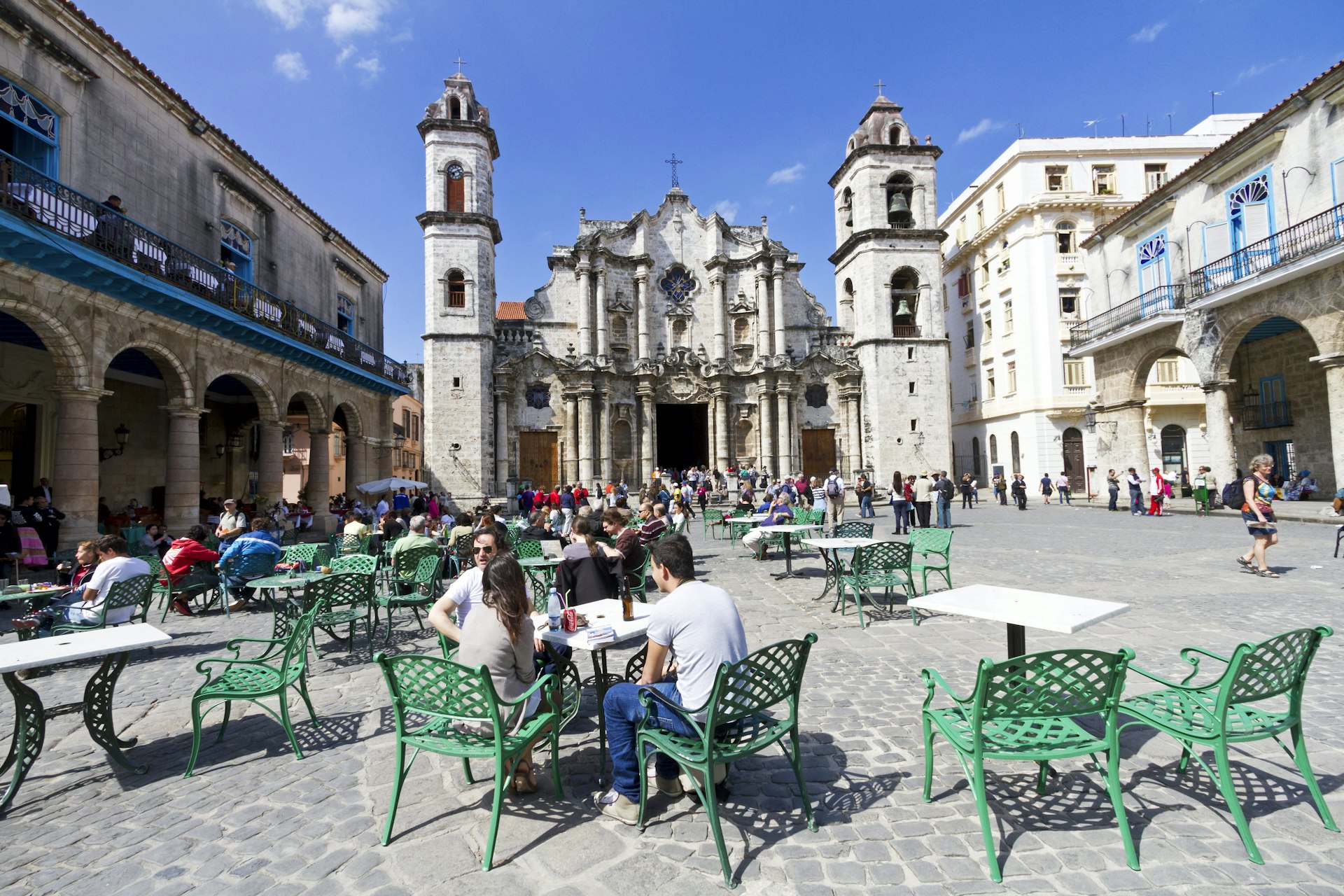
Return to map view, and then drop onto one of the photo spheres on Plaza de Armas , once used for military exercises. The plaza is still guarded by the Castillo de la Real Fuerza , a beautiful 16th century star-shaped fort. Drop onto the castillo’s photo spheres to take a look around its perimeter. If you turn east, you’ll also be treated to a great view across Havana Port.
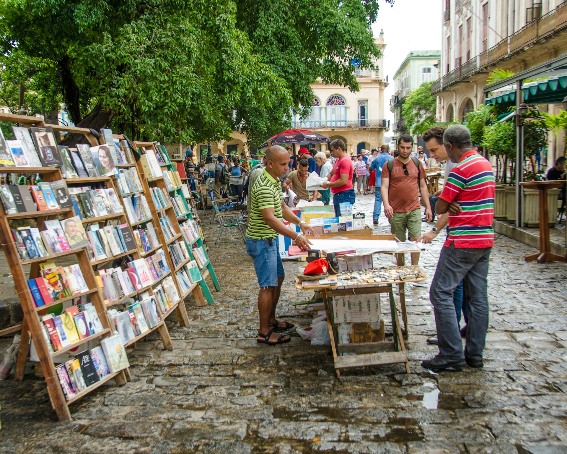
Just south of the castillo is Palacio de los Capitanes Generales , the former official residence of the city’s governors. Return to map view and drop onto one of the palacio’s photo spheres to take in the building, which is also home to the Museum of the City of Havana . Next, return to map view and drop onto a photo sphere along Calle Obispo , one of the city’s most bustling and lively streets. This is a great street to wander up and down. After returning to map view, drop onto the cluster of photo spheres on Plaza de San Francisco de Asis , a breezy open space watched over by the Iglesia y Monasterio de San Francisco de Asis . Finish your tour by dropping down at the photo sphere just north of the Terminal Sierra Maestra , and gazing out across the port.
Find the map route here
Split, Croatia: Split’s Old Town Walking Tour
Start this virtual tour through Split’s fascinating Old Town by dropping onto the photo sphere at the foot of the Bell Tower and Chapel of the Holy Arnir , once part of St Euphemia’s Church, containing an altar slab and sarcophagus carved by the early renaissance master Juraj Dalmatinac. Using street view, head southeast along Ul. Kralja Tomislava, until you reach the imposing statue of Grgur Ninski , whose toe is said to bring good luck when rubbed (clicked). Return to map view and drop onto the statue’s photo sphere to check it out. Using street view, head south from the statue to the Golden Gate , the grandest portal of Diocletian’s Palace , an ancient palace built for Roman Emperor Diocletian.

Return to map view, and continue south along the palace’s main, bustling street, Dioklecijanova , using street view. At the end, return to map view and drop onto the photo sphere at peristil , the ceremonial court at the approach to the imperial apartments. Spend a second taking in your surroundings. Return to map view, and drop again onto one of the photo spheres next to the imposing St Domnius Cathedral . Return to map view and drop down onto the Ul. Andrije Alješija . Spend a bit of time exploring this area of medieval buildings and narrow alleyways using street view.

Return to map view and drop down somewhere along Narodni Trg , which has been Split’s main civic square since medieval times. Take some time using street view and its many photo spheres to explore. Although the square was once lined with Venetian Gothic buildings, only one remains, the 15th century Stara Gradska Vijećnica (Old Town Hall). Conclude your virtual tour by dropping onto the hall’s photo sphere and checking it out.
Melbourne, Australia: Arcades and Laneways Walking Tour
Central Melbourne is a warren of 19th-century arcades and gritty-turned-hip cobbled blue- stone laneways featuring street art, basement restaurants, boutiques and bars. Start your tour by dropping onto street view at Degraves Place , an archetypal Melbourne lane lined with interesting shops, cafes and street art. Head north from Degraves Place to Flinders Lane, return to map view and explore the nearby Centre Place , a bustling hub of cafes and bars, using its photo spheres. Return to map and drop back onto Flinders Lane, head west, and then make a right hand turn onto Elizabeth Street. Continue north until you reach the Block Arcade . Built in 1892 and featuring ornate plasterwork and mosaic floors, it’s based on Milan’s Galleria Vittorio Emanuele II arcade. Return to map view and drop onto one of the arcades photo spheres to take a look.
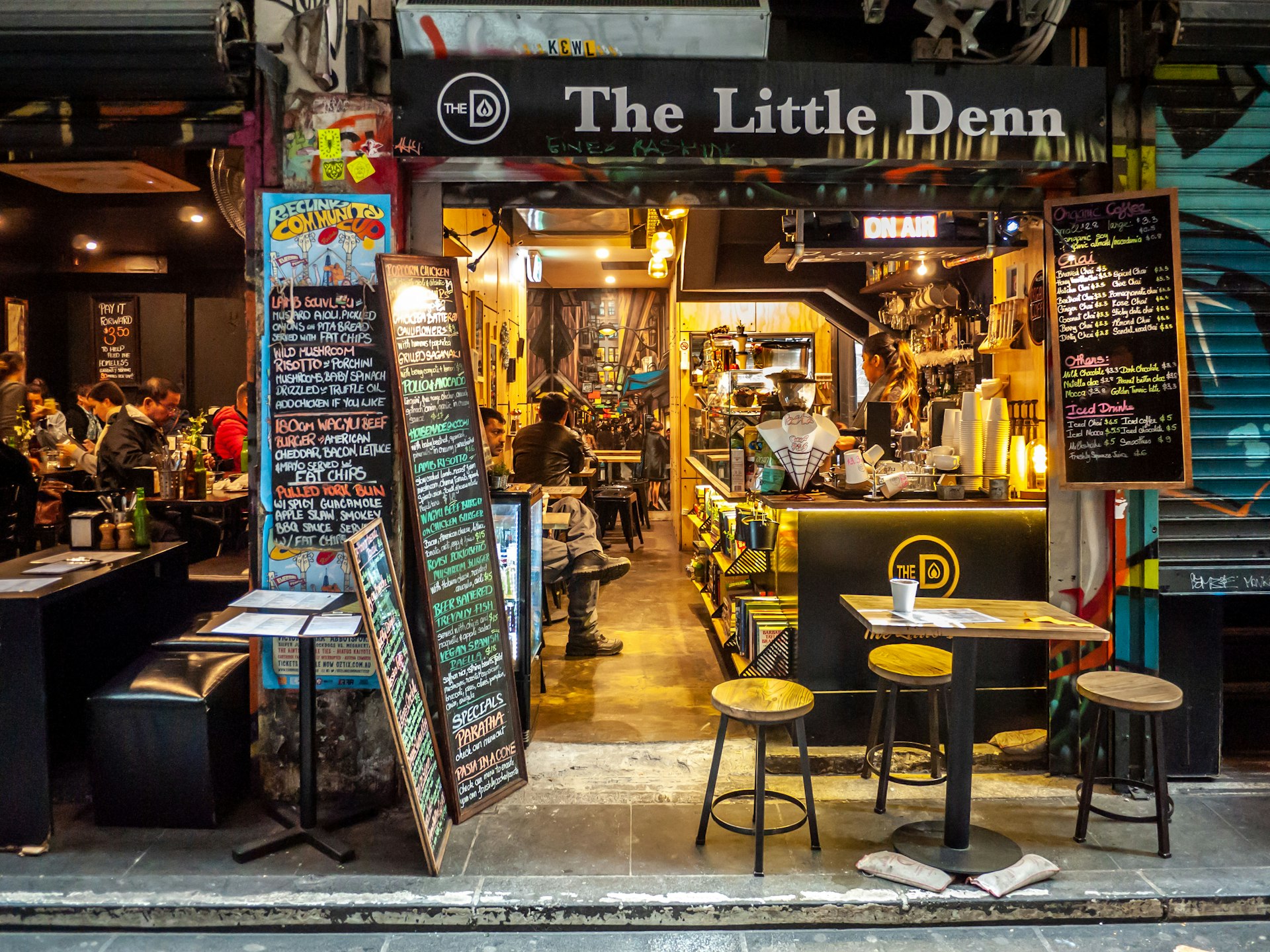
Return to Elizabeth Street using street view, and navigate north, turning right at Little Collins Street. Navigating east along the street you’ll find the wonderfully ornate Royal Arcade on your left. Return to map view, and drop down onto the arcades photo sphere to look around. Return to Little Collins Street on street view, and continue east until you find a turning on your left to Union Lane Graffiti . Spend some time on its photo spheres to soak in the urban art. Return to Little Collins Street again on street view, continue east, and turn right onto Swanston Street. Move south, until you reach Melbourne Town Hall on your left. Drop onto a photo sphere in front of the hall and admire its impressive facade.

Return to map view, and drop onto Collins Street next to the town hall. Continue east along the street, and then turn right onto Russell Street. Continue south, and then turn left onto Flinders Lane. Continue east along the lane, and you’ll reach Duckboard Place on your right. Wander around using street view, taking in the plentiful urban art. Return to map view, and drop down to end the tour on Hosier Lane ’s photo sphere, one of the city’s most epically decorated alleyways.
Rio de Janeiro, Brazil: Rio Walking Tour
A mélange of historic buildings and skyscrapers, the center of Rio is an intriguing place to discover the essence of the city away from its beaches and mountains. Begin by dropping down onto a street view of the Praça Floriano , a scenic plaza set with several outdoor cafes. Navigate around at street level and take in the views. Proceed north along the Praça Floriano , until you reach the Municipal Theater of Rio de Janeiro , one of the city’s finest buildings, particularly after its $20 million renovation in 2009. Return to map view and drop onto a photo sphere facing the theatre to take in its grandeur.
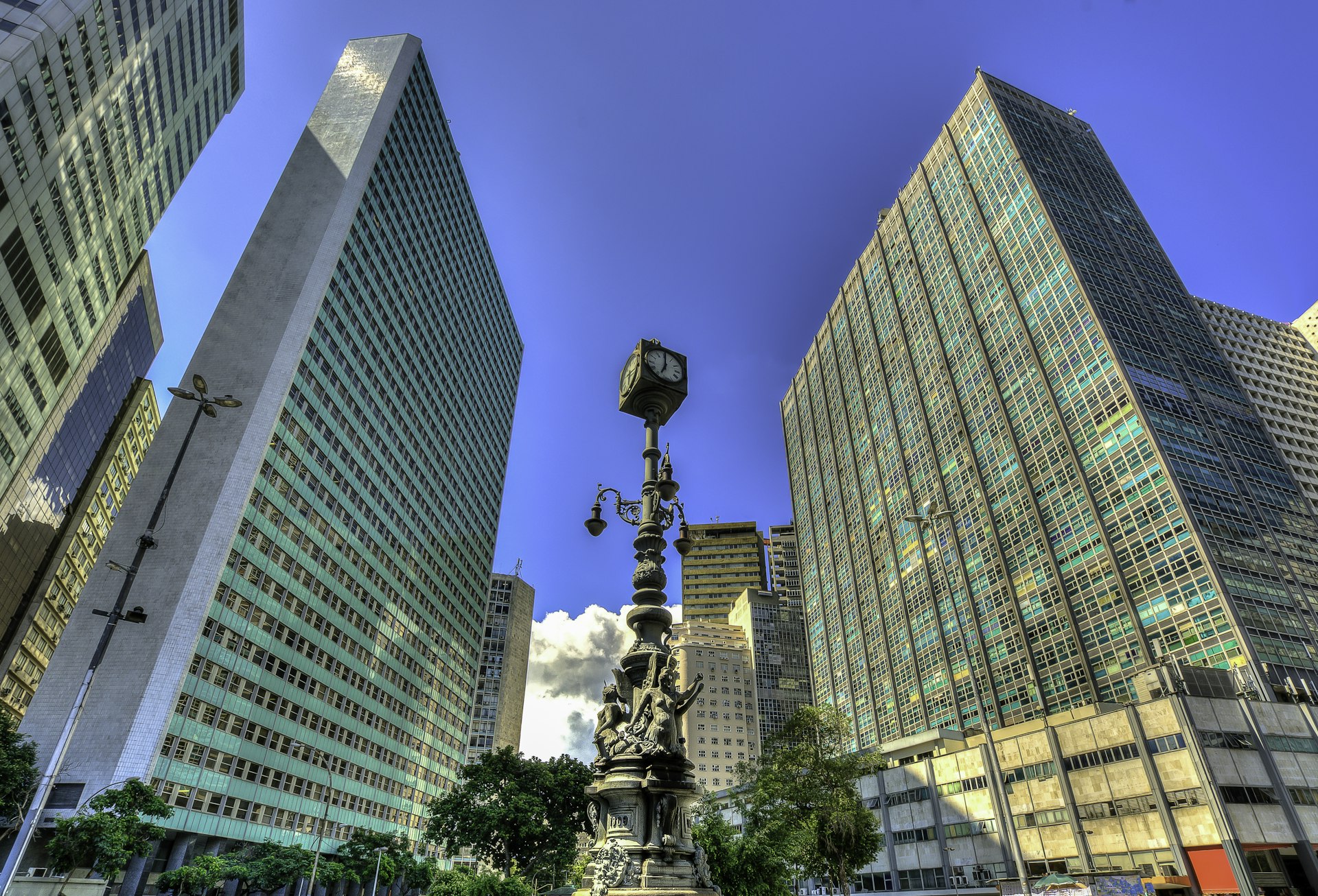
Return to map view, and drop down onto street view of Largo de Carioca , a bustling area with a small market. Wander around using street view. Facing north, you will be able to see the Igreja São Francisco da Penitência , a 17th‐century church with a jaw‐dropping gilded interior perched up on a hill. Return to map view, and drop onto Rua de Carioca. Navigate west along the road, until you reach a right hand turn onto Praça Tiradentes. Continue north on Av Passos, turning right onto R. Luis de Camores. Along this road on the left you’ll find the Real Gabinete Português de Leitura (Royal Portuguese Reading Room), a historic reading room reminiscent of 19th century Portugal. Return to map view, and drop onto one of its photo spheres to explore the book-lined interior.

Return to map view, and drop down onto street view by Paço Imperial , once the seat of the Portuguese rulers in Brazil, the building today houses intriguing art exhibitions as well as several cafes. Spend some time exploring using street view. Navigate onto R. Primeiro de Marco, and work your way northwest, until you reach a righthand turn to Largo do Paço. Navigate east until you reach the Arco do Teles . Go through it, and you’ll finish your tour on Travessa do Comercio , one of the centro’s oldest and most charming lanes.
Bangkok, Thailand: Old Bangkok Walking Tour
The bulk of Bangkok ’s ‘must-see’ destinations are in and around the former royal district, Ko Ratanakosin . Start your virtual tour by dropping onto one of the many photo spheres at the Temple of the Emerald Buddha: Wat Phra Si Rattana Satsadaram / Wat Phra Kaew , a vast, fairytale compound that is one of Bangkok’s biggest tourist attractions and a pilgrimage destination for Bhuddists. Have a look around you using the multiple photo spheres on the site. Once you’re done, jump to the Grand Palace , the former resident of the Thai monarch (which is right next door), and do the same.
Return to map view and then drop again at Maha Rat Road. Navigate north until you reach Soi Tha Wang, enjoying the surroundings as you go. Return to map view, and drop down onto the photo sphere spot on Soi Tha Wang, a narrow alleyway holding a hidden classic Bangkok neighbourhood. Return to map view and drop back onto Maha Rat Road. Head north, and find the amulet market on your left, a frenetic handicraft market selling Bhuddist amulets and good luck charms. Return to map view.

Drop again onto Phra Chan Alley, and head east until you reach the gates of Sanam Luang , the ‘Royal Field’, which is an open public square on the edge of Wat Phra Kaew. Return to map view and drop onto the photo sphere on Sanam Luang for a different perspective of the temple. Return to map view and drop again onto Ratchadamnoen Nai Road.
Continue north until you reach the Royal Hotel. Follow the road’s curve east onto Ratchadamnoen Klang Road , considered the Champs Elysees of Bangkok. Continue along it until you reach the 14 October 73 Memorial , commemorating the civilian demonstrators who were killed on 14 October 1973 by the military during a pro-democracy rally. Drop onto a photo sphere to look around. Continue in the same direction and you’ll reach the Democracy Monument on a roundabout, erected in 1932.

Return to map view and drop onto Dinso Road. Continue south and follow the road curve west onto Bamrung Mueang Road. Follow the road until you reach a left hand turn onto Atsadang Road. Continue until you reach a right hand turn to Charoen Krung Road, and head west, stopping to check out Saranrom Palace Park on your right as you go. Return to map view and drop onto any of the park’s photo spheres to look around. Return to map view and drop onto the photo spheres on the tour’s final stop Wat Phra Chetuphon , home of the giant reclining Buddha.
You might also like:
10 of the world’s coolest neighbourhoods , rio de janeiro is named the first-ever world capital of architecture, the best board games for travel lovers, explore related stories.
Tips & Advice
Apr 28, 2024 • 6 min read
Find out how to make your bhat stretch further with these budget travel tips for Chiang Mai, Thailand's “Capital in the North.”

Apr 25, 2024 • 6 min read
Apr 19, 2024 • 7 min read

Apr 18, 2024 • 12 min read

Apr 16, 2024 • 6 min read

Apr 8, 2024 • 6 min read

Mar 8, 2024 • 10 min read

Feb 23, 2024 • 7 min read
Jan 5, 2024 • 20 min read

Jan 3, 2024 • 5 min read

How to Use Google My Maps to Plan a Trip (Ultimate Guide)
Note: Some of the links in this post may be affiliate links. This means if you click on the link and purchase the item, I will receive a commission at no additional cost to you. More details are here .

I love a good map. I’ve got maps hanging on my walls. I go to the bookstore to read maps. Whenever I navigate my way home using only a map, I feel like I must have some innate bushcraft skills. And if you’ve read my posts about traveling in Maine , you’re probably sick of me talking about the DeLorme Atlas by now.
But while reading paper maps will always inspire a sense of get-up-and-go adventure for me, I’m not totally opposed to using tech for planning my trips and navigating on the ground.
And one of my favorite techy solutions? A secret little trip planner called Google My Maps, buried inside of everyone’s favorite map tool.
Google My Maps lets you create shareable custom maps with multiple layers, plus location pins with icons and notes. It’s a great way to brainstorm travel plans or create a trip itinerary from a desktop. And since the map can be viewed in the Google Maps app, you can use it to navigate on the go.
To give you an example of what this post will show you how to do, here’s one of the custom Google Maps I’ve created for a trip.
Keep reading for an overview of how to use Google My Maps to plan a trip, plus a video tutorial of how to set it up—all updated in 2023. I’ll also share answers to commonly asked questions and some lesser known tips to help you get the most out of this tool.
A quick note: Creating a custom map in Google My Maps is distinct from Google Lists of saved places. Check out our Google My Maps vs Lists comparison to see all the differences and our full guide to using Google Maps Lists .
8 Top Google My Maps Features
(AKA Why It’s Awesome)
Google My Maps allows you to see your trip itinerary.
This is so helpful, especially if you’re a visual person or enjoy using maps. But even if you’re not, it’s still really useful to see where everything is in relation to each other as you plan your trip, vacation, or holiday because it helps you be realistic about your plans.
It connects with other Google apps.
Setting aside my (ahem, very rational) fear that they may take over the world soon, I love all things Google. My Maps stores a copy of the map in whatever Google Drive account you’re using. (Am I the only one who has six of these?) So if you like to create Google Docs or folders to store trip planning information, documents, photos, or itineraries, it’s nice to have your map easily accessible in the same folder.
You get additional location information since it’s part of Google Maps.
If a location is on Google, you can see their website, phone number, address, reviews, and website when you add it to your custom map. (Note that you can’t see this information when clicking on your saved pin from the Google Maps app, but you can from desktop.)
You can add your own extra notes and photos.
Customize your map even more by adding notes, photos, or videos. Use the notes during planning to add website, hours, or tips. If I hear about the location from a particular website, I usually add that link and what was noted in the article about the location (e.g., it’s a great sunset spot, which dish on the menu is recommended) so I can reference it later.
You can view your route by creating a layer with directions.
When I traveled to Burlington, Vermont, I wanted to see the length of the bike trail on the map, so I used the directions feature to show the whole route. (Check out the Burlington travel guide for an example of the travel map I created that includes the bike path route.) And while I haven’t done this yet, you could also use Google My Maps to plan a road trip itinerary for a longer adventure.
Caveat: As I’ll discuss later, you can’t use directions layers to get turn-by-turn directions (but I mention an alternative below). For this reason, I only use these layers to visualize my route.
It’s highly customizable.
Don’t mind me while I swoon over the color coding and organization options over here. Use custom icons, layers, and colors so it’s easy to see what things are at a glance. For example, you can give different locations individual styles: a coffee cup icon for cafes, a bed icon for hotels, and a swimming icon for beaches. You can also use layers in many different ways, such as one layer for each day of your trip or one layer for each category (like dining, lodging, and things to do).
In-depth planning on your computer. Easy, on-the-go access from your phone.
While you can’t edit the maps from the Google Maps app on iPhone or Android, you (and anyone you’ve shared them with) can view them. You can click on icons and see your notes, as well as navigate to those locations.
Note that there used to be a dedicated My Maps app on Android, but this has been deprecated.
It’s easy to share it with a friend or with the world.
If you’re planning a trip with other people, it’s easy to share the map with others . And if it’s something you want to make available to everyone (like I do on my travel guide posts), just change the privacy setting and share the link or embed it on a website.
3 Ways to Use Google My Maps
Brainstorm and store ideas for future “maybe” trips.
I often come across a really interesting hotel, restaurant, or fun thing to do in destinations I want to travel to in the future, and I want to make sure I don’t forget about them. I have so many bookmarks in so many places (Pinterest, Facebook, Instagram), but Google My Maps is the place I’ve started storing ideas for future trips.
Plan your trip itinerary.
Want to use Google Maps for route planning? When you’re ready to plan an upcoming trip, plot it out visually by using Google My Maps to create your itinerary. If you like structured itineraries, you can easily create a detailed day-to-day plan.
Or, you can use a looser itinerary structure like we usually do by adding all the places you might like to go.
For example, on a day trip to NYC, we added tons of places to eat on the map (thank you, Tiktok). As we were walking around doing other activities and started to get hungry, we were able to easily see which saved restaurants were closest to us.
Navigate on the go.
Whether you’re using your map loosely for ideas or for a structured itinerary, you can pull it up on your phone anytime and get directions to your next location.
Not sure what you want to do today, or want to see what the closest restaurant from your list is for dinner? Pop into your custom map to jog your memory from the notes you made or to get directions to your next location.
Recommended: Need an organized backpack to take on the road? Check out my favorite luggage for camping, road trips, and flying: the Cotopaxi Nazca 24L and Allpa 35L !
How to Use Google My Maps to Plan a Trip
How to create a new custom map.
Go to Google My Maps from your desktop browser . Check the Google icon in the top right corner to make sure you’re using the Google account you want to. Click “Create A New Map” and a window will open with a blank map. To give your map a name and description , click the map name (“Untitled Map”).

You can also change the color and style of the base map if desired. At the bottom of the layer panel on the left, click the arrow next to “Base Map.” You’ll get a window with nine options, including terrain, light political (a very light version of the standard Google Maps), satellite, and some different colored versions. Note that changing the base map style on desktop won’t change anything when viewing on mobile in Google Maps.
How to Add and Edit Layers
When you create a new map, the first layer will already be created, so you’ll probably want to rename it. To give your first layer a title , click directly on the title name like you did with the map name, or click the 3 dots next to “Untitled Layer” and then click “Rename Layer.” Clicking these 3 dots next to a layer title is also how you can delete a layer if you add one accidentally or change your mind. In this example, I’m changing my first layer to “dining” and will add all restaurants to this layer.
You can use layers any way you want to, or simply stick to one layer if you don’t need multiple. To add new layers , simply click “Add Layer” in the gray section below the map title and description.
To move a pin between layers , click the pin on the layer and hold down the mouse, and then drag it to the desired layer.

How to Add Location Pins
There are various ways to add location pins to a layer. First, make sure the correct layer is chosen by clicking anywhere in the white area on the layer. You’ll see which layer is selected by looking for the blue bar on the left of the layer.
- In the map search bar, type either a place name or an address. Click “Add to Map” to add a pin for this location . This is how I add most pins.
- If you don’t need an exact location or don’t have an address , you can click the pin marker button below the map search bar (“Add Marker”). It will turn your mouse into a T and you can click anywhere on the map to add a blank pin. You’ll immediately be prompted to add the pin title and description.
- If you’re dealing with very remote locations (or you just like geeky map stuff), you can also use latitude and longitude coordinates in the search bar.
To delete a pin , simply click on it and click the trash icon.

A few tips and best practices for adding pins:
- If the place you’re searching for does not have a listing on Google, you’ll have to use an address. One thing to note is that sometimes Google Maps listings aren’t correct or don’t take you to the right place, so you may want to double check the location if you’re not using a street address to add the pin (especially if it’s a small business without a website).
- I have also found that hiking trail heads are frequently on Google Maps, but they’re not always correct in terms of navigating there by car. I usually add them to my map to get a basic idea of where they are while planning, but I use a paper map or atlas to find them while traveling.
How to Customize Location Pins
To change the title and add notes to your listing, click on the pin on the map, and then click the pencil icon (“Edit”).
To change the color and icon of the pin , click the paint bucket icon (from the pin itself or directly in the layer). Click “More Icons” to view all the icon options. You can color code by type of activity, by layer, or any way that makes sense to you.
To add photos or videos to a pin , click on the pin on the map, and then click the camera icon (“Add Image or Video”). This is another way to make your map interactive, especially after you’ve visited a location and want to share it with others.

How to Add A Directions Layer
I find that directions layers are helpful for showing the route of a walking tour, bike path, or road trip you want to take, but I don’t find them useful for directions while traveling since I can simply use the maps app to navigate.
I use directions layers whenever I want to show an entire route on a map , rather than a specific location. Think of this as the 2024 version of mapping out a trip with AAA paper maps and a highlighter (if you’re old enough to remember).
Click the arrow icon underneath the search bar, which will create a new directions layer. On the legend, click “Driving” if you want to change this to walking or biking directions. Add a location name or address to Points A and B in the legend. If you find that the pins are not exactly where they should be, you can drag the points on the map.
Continue adding points by clicking “Add Destination” on the map. You can either type the information into the legend or hover your mouse to a spot on the map and double click it. (This is especially useful if you’re tracing a route on something like a bike path or hiking trail that won’t have an address.)
Rearrange the order by dragging the items around in the legend. Just like altering directions on Google Maps navigation, you can click on part of the route and drag it to a different road if you want to change part of the route after it is complete.
If you need to access the directions so you can see the distance of your route or the time it will take, click the three dots on the layer and click “Step-by-Step Directions.” Note that you can’t actually use this to get turn-by-turn directions in Google Maps.

How to Share A Google My Map
There are several options for sharing your Google Maps trip plan.
Open up your map, then click the share button in the gray bar above your layers. To allow others to view your map (which includes embedding on your website), click “change” under the section “Who has access.” For embedding, you will need to make this setting public.
Otherwise, if you want to allow others to edit your map, add their email address in the “invite people” section.

How to View Your Custom Map in Google Maps (iPhone or Android)
Open Google Maps and go to the Saved icon at the bottom. Scroll to the bottom of this screen and click “Maps.” Choose the My Map you want to view. The layers with your custom icons will now be visible on your Google Map. You can click on any pin to view your details (such as description or photos), as well as to navigate there.
To close a map, click on a pin and then click “View Map Legend.” There, you can click the Close icon.
From the Map Legend, you can also toggle layers on and off, and then backing out to the main map (don’t click Close—just the back arrow or back button).
How to Navigate with a Custom My Map (iPhone or Android)
To navigate to one of your pins, open your map, find the pin for where you want to go, click it, and then click “directions.” When you do this, you won’t see your custom map anymore but will be looking at the regular navigation of Google Maps.
You can’t use a My Maps “directions layer” for navigation. If you’re looking for that functionality, I recommend just creating a route in Google Maps and sending it to your phone (or sharing with others). See here for more details.
How to Import Locations from Google Sheets, CSV, or Excel
Importing locations to a My Maps layer can be helpful in a few scenarios:
- You have a significant amount of locations to add to your layer
- Your data is already in the form of a spreadsheet
- You want additional fields included besides the default Name and Description
- You want to create groupings of pins (for example, a list of 50 restaurants could have a column for “Cuisine,” which will give you the option to group and style the pins by cuisine)
The process is simple, and you can import a variety of file types, including CSV, Excel (XLSX), or directly from Google Sheets. There are also special file formats that import map data from other programs, but this section is focused on spreadsheet-type files that you create and format.
Create a spreadsheet with the desired column headers. At a minimum, you need place names and either addresses or latitude-longitude information .
If you want to group your pins by some type of categorization, you should include that as a column. Other columns you could include: website, phone number, description, or notes. While Google Sheets allows you to include photos in a cell, Google My Maps will not import photos in this way (it will include the column as a field, but will be blank).
Once your spreadsheet file is ready, click “Import” on a blank layer (if your map already has layers, you will need to add a new layer to see this option). If uploading a CSV or XLSX, do this from the Upload tab. If using a Google Sheet, click the Google Drive tab and choose your file.
Choose which column has location data (address or latitude-longitude) and click “Continue.” Choose the location name column next and click “Finish.”
To change the icons individually, click “Uniform Style” next to the paintbrush on your layer. Under “Group Places By,” choose “Individual Styles.”
To change styles by a category column (such as Cuisine), click the link next to the paintbrush and choose to group places by the desired column. You can then give each category its own color or icon.
You can manually add new pins to this layer, and they will include all the fields you imported from the spreadsheet columns.
You can also add more items to your spreadsheet, and import this new data. Click the three dots on your layer. Under “Reimport and Merge,” click “Add More Items” and choose your file. It will add the new rows to your layer.
How to Import a Route from Google Maps Timeline History (KML) or GPS Data From a Fitness App (GPX)
Google My Maps can import routes and locations you’ve already traveled to via special file types that are very easy to download from certain apps. This could be useful if you want to share a walking, biking, or driving route that you’ve taken without having to recreate it on a directions layer.
Note that this only works as well as the GPS satellites were able to track your location while you were traveling.
If there are a lot of clouds, dense forest, buildings, or anything else blocking the GPS signal, your tracked route will be much less precise. I’ve noticed that Google Maps sometimes has my route showing somewhere I couldn’t have walked or driven.
If you have your location history turned on in Google Maps, you can download a KML file from a trip, which will include the route traveled and location pins for any stops. Sometimes it misses a location name or adds a pin in the wrong place, but overall it’s pretty good.
Go to your Google Maps Timeline and locate the day you want to export. Click on it, and you should now see your route highlighted along with any stops you made. Now click the gear icon on the bottom of your map, and click “Export this day to KML.” Go to your My Map and on a new layer, click “Import.” Choose the KML file you just downloaded. You can now edit each portion as needed—changing the color and thickness of the route line, changing the location icons, as well as adjusting the route where desired.
If you have other apps that track your location, such as fitness apps, you may be able to download a GPX file that shows the route you took. The instructions for doing this will vary from app to app, but I was able to easily find it in Samsung Health by looking at the detail of a particular workout/walk and clicking the three dots to download a GPX. The import process to Google My Maps is the same as above.
With both methods, you can make adjustments to points/stops along the way or even add more pins. With the Google Maps KML file, you can also adjust your route by moving the small white dots.
Google My Maps Tutorial
Here’s a walk through video to show you how to use Google Maps to plan a trip, along with several of my own Google My Maps itinerary examples. Coming soon: a 2024 update!
Google My Maps Examples
Here are a few more examples of My Maps I’ve created for sharing recommendations, trip ideas, and actual vacation planning.

Google My Maps FAQs and Tips
As great as Google My Maps is for planning a trip, there are some limitations to using it. Lots of questions have also come up about more specific uses and ways to use its features. Thanks to all the readers who have asked or shared tips in the comments as I’m always looking to make this a more robust guide. I’ve organized the questions and tips here since it makes it easier than scrolling through the comments.
How many layers can you add to a map?
Google My Maps limits you to 10 layers. If you are planning a longer road trip and want to create a layer for each day, this limitation may prove frustrating.
Here are a couple of workaround ideas: You can create 2 maps, and have the entire master route as 1 layer on each (showing the very basic route for all 12 days—say from city to city) as a reference. Then build individual layers for each day. As a second option, you could add multiple days to 1 layer and change the titles to start with the day they correspond to (so it would be “1 – Name of Place” instead of just “Name of Place.”) However, this option may not be ideal since you can’t see the titles until you click when you’re on the phone.
How many location pins can you add to each layer?
You can add up to 2,000 pins per layer, and the entire map cannot exceed 10,000 lines, shapes, or places total. I haven’t tested the limits, and it’s possible adding this amount of items could slow things down. My guess is that most travelers wouldn’t need anything so large, but it is possible according to Google .
Are custom Google My Maps available offline?
No, but keep reading for a workaround and alternative.
One of the biggest complaints about Google My Maps is that you can’t download your custom map and pins to use offline, unlike the rest of Google Maps.
However, I have been able to use it in areas with spotty reception. I pulled the map up when I did have reception, and I left it running in the background. It would stay loaded in the app and I was able to pull it up to look at it later when I was out of reception. I’m not sure I would rely on this as a surefire workaround, but it can work in a pinch.
Another alternative, especially if you’ll be traveling in another country where you’ll be completely offline, is to use Google Maps Lists, which can be edited from desktop or your phone but don’t offer the option for separate layers, unique icons, or adding photos.
Is there an app for Google My Maps?
There is no separate Google My Maps app, but you can view your maps within Google Maps. Just make sure you’re signed into the same account, and all your maps will sync.
(There used to be a dedicated My Maps app on Android, but this was deprecated in 2021.)
Can you create or edit maps from your phone?
No, the maps cannot be edited from the Google Maps app. Google My Maps can only be created or edited from the desktop version of the site. This is another huge advantage Google Lists has over Google My Maps because Lists allow you to add new places or entire lists from any device—iPhone, Android, tablet, laptop, or desktop.
Is there a bridge height filter?
No. For RVers and others who need to plan ahead for height limitations, there is no bridge height filter available in Google Maps. Since I haven’t had to use this feature myself, I am not confident in an alternative to recommend. However, from a bit of digging around, there are some apps and GPS units for truckers that may be a good place to start looking if you have an oversize vehicle.
What is the difference between Google Maps Lists and Google My Maps?
They both allow you to create custom maps with pins, but there are some key differences, such as offline access, layer capabilities, customizable pins, and creating/editing within the app. Check out the details on how Google My Maps compares to Lists (including a features comparison table).
How many stops can you add on a directions layer?
You can only add 10 stops per directions layer. This is also the maximum number of stops you can add for navigation in Google Maps. As some readers have pointed out, this can be limiting when you want to use this feature for a long road trip.
Can you use the directions layers on your phone for navigation purposes?
No, you cannot create a directions layer and then access those turn-by-turn directions for navigation in the Google Maps app.
So…are directions layers totally useless? What’s the point of having a Driving Directions layer in My Maps?
Personally, I still like to use these layers, but only to show a route for my very visual brain, rather than to actually create custom directions.
Can you send a custom created route (layer) to someone else so that the other person will take that specific driving route on google maps?
No, you can’t do this from My Maps, but there’s a workaround I can suggest.
Forget My Maps, and use Google Maps from desktop or mobile to plot a route. You can add up to 10 stops, and then you will be able to share your custom directions.
From desktop, there’s an extra step in first sending the directions to your phone. If you’ve created the directions in the mobile app or once you have them pulled up there, you can share them with anyone by clicking the 3 dots next to your list of locations (sharing must be done before clicking “Start”—if you’re already in the navigation, you need to back out of it to share). When you share, it will list all the steps as well as send a link for the other person to open the directions in Google Maps directly.
An important caveat to sharing custom routes: Google Maps will reroute the directions as it normally does according to current traffic at the time of driving, so this method cannot be relied upon if you’ve mapped a specific route for bridge clearances. As a workaround, you can add “stops” on the desired interstate (zoom in and add this literally on the road itself so navigation doesn’t try to take you off an exit), which will force Google Maps to take the driver that way. This is what I do when driving south from Connecticut to PA because Google Maps always wants me to take its beloved George Washington Bridge and I always don’t want to. I add a stop to force my route across the Tappan Zee Bridge. However, I’m not sure I would rely on this workaround as a sole method for RVs or truckers.
Can you see how much time the directions will take?
Yes, on desktop you can view the details if you want to know the distance or how long a route will take. To view distance and time for a directions layer, click the 3 dots on the laye, then click Step-by-Step Directions.
Of course, this doesn’t really help when you want to get this information on your phone or use the directions for navigation. As mentioned elsewhere, the “directions” layer functions best as a way to visualize a route. If you need turn-by-turn directions, see the steps mentioned above to save and send directions in Google Maps.
This post was originally published on July 27, 2017 and has been updated in May 2023.
Travel Photographer | FAA Certified Drone Pilot
Naomi is the coffee-loving, crazy-about-Latin-America writer and photographer behind everything here. She's guided by curiosity and a belief that every place has a story to tell–whether it’s through the intricate details of nature, history that has shaped a culture, or the people who call a place home. Learn More
How to Use Google Maps to Plan Your Next Road Trip (Step-By-Step Tutorial With Examples)
Post summary: A comprehensive guide on how to use Google Maps to plan a road trip itinerary and why Google Maps is the best tool/app for planning a trip. Includes a road trip planning tutorial!
Author’s Note: This post was originally published in 2020 and was updated in April 2023 for accuracy and comprehensiveness.
So, you want to plan a road trip. But, where do you start? Better yet: How do you start?
I’m often asked about my trip planning process. Where to go, what to do, and how exactly to fit everything into a cohesive itinerary that, well, makes sense .
Planning a road trip can be hard. But, with the right tools and resources, it doesn’t have to be. I’ve already put together a list of my most trusted travel booking resources , and the best apps for road trips , but now I want to talk about one of my favorite road trip planning tools: Google Maps.
Google Maps is like a trip planning goldmine, and it’s always my very first step in organizing my itinerary whenever I take a trip.
Google Maps is one of the best tools for planning a cohesive and successful road trip, because it allows you to create a highly customizable, visual representation of your trip (shoutout to all my fellow visual learners out there). And its FREE!
Basically, if you’re planning a road trip, knowing how to customize Google Maps is going to make your life so much easier.
So if you’re wondering how to get started, then you’ve come to the right place. I’m breaking the entire process down into an easy to follow step-by-step tutorial on exactly how to use Google MyMaps to plan your next road trip. So, lets get started!
GOOGLE MAPS TRAVEL PLANNING OVERVIEW
Here’s exactly what we cover in this guide:
- Create a new Google Map for your trip.
- Add location pins to your map
- Customize and color code your location pins.
- Create Google Map layers to plan your day-to-day itinerary.
- Add driving directions to your map.
- Download your custom Google Map to your phone.
- Share your map with friends.
- Calculate gas milage for your road trip.
Scroll down for a super detailed step-by-step guide to planning your own travel itinerary for free using Google Maps or skip ahead with the table of contents.
Table of Contents
Need some road trip inspiration? Visit my most popular travel guides:
Las Vegas to Sedona Road Trip (3 Jam-Packed Itineraries to See it All in Less Time)
5-Day British Columbia Road Trip Itinerary
1-Day Yoho National Park Road Trip Itinerary
The Perfect 2-week Costa Rica Itinerary
. Don’t forget to grab my FREE Travel Expense Planner Download below to help you plan your next trip . Use it to easily and automatically calculate how much money you’ll spend on gas, flights, accommodation, food + more
WHY GOOGLE MAPS IS THE BEST TRAVEL PLANNING TOOL FOR YOUR NEXT TRIP
Google Maps is the best tool for planning your next trip , whether you’re just using it for adventure inspiration, to share ideas with your friends, or creating a detailed step-by-step road trip itinerary. Here’s why!
IT CREATES A VISUAL REPRESENTATION OF YOUR ROAD TRIP
If you’re a visual learner, Google Maps is going to be your best friend. But even if you’re not a visual learning, using Google Maps to plan your trip is still going to be incredibly helpful.
Planning your trip with Google Maps is the fastest way to familiarize yourself with the layout of an area. It allows you to wrap your head around how large an area is and where everything is in relation to each other, which, in my opinion, is the best way to start planning any trip.
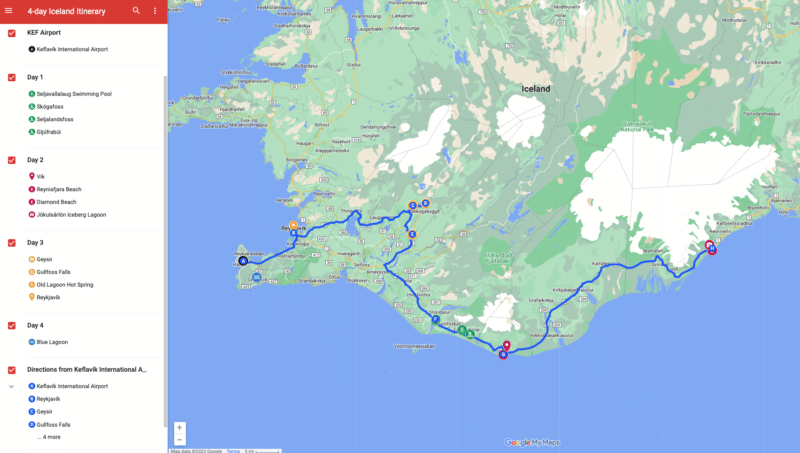
Here’s an example of the Google Map I created for our 4-day road trip in Iceland.
Click here to access the interactive map.
GOOGLE MY MAPS HELPS YOU FIGURE OUT WHERE TO SPEND YOUR TIME
Have you ever had a list of places you wanted to see, only to find out that they’re super far away from each other?
Pinning your locations to your custom Google Map will show you where your stops are. This will help you figure out where to spend your time and plan accordingly.
Are your pins clustered in one place? If so, then you might want to allocate more time to that area. Or maybe your pins are spread out all over the map? If this is the case, then it might be best to prepare yourself for a lot of driving or focus on a smaller area instead.
YOUR GOOGLE MAP IS HIGHLY CUSTOMIZABLE
Whether you’re touring NYC, road tripping cross country, or backpacking to Beaver Falls in the Grand Canyon , you can create a highly customizable Google Map to help plan your adventure.
Handy features like customizable locations, adding multiple stops, pinning by GPS coordinates, organizing by categories, and overlaying direction layers, all make it incredibly easy to customize your Google Map to plan your travel itinerary.
Need to remember entrance fees, operating hours, or best places to see? You can even add notes to your location pins so you don’t forget important details!
IT HELPS YOU NAVIGATE AND PLAN YOUR ROUTE
Quickly learn how to navigate between stops by adding directions between multiple locations to your map.
This is an incredibly useful tool for figuring out the best routes to take, roads to avoid, and to plan for drive time. You can even choose between walking, biking, or public transportation directions. This is especially helpful for choosing the best entrance to Yellowstone National Park , taking the scenic route on an Ecuador road trip , or mapping out the best Hudson Valley wineries .
IT’S EASY TO COLLABORATE AND SHARE YOUR TRIP
Traveling with friends? Google Maps makes it super easy to collaborate by allowing you to share your map with your travel partners. You can even give them editing access so that everyone can add their must-do’s to the map.
YOUR MAP IS EASY TO SHARE BETWEEN DEVICES
You’ll have to create your Google Map on desktop. But, luckily, you can seamlessly share your custom map straight to your iPhone or Android using the Google Maps App!
Sharing your custom map to your phone makes it super convenient to access your itinerary on the go. You can even set up your map for offline use if you’re traveling without cell phone service.
HOW TO CREATE A CUSTOM MAP IN GOOGLE MAPS: A STEP-BY-STEP GUIDE
1. create a new google map, login to google drive on your desktop.
Before you start planning your road trip using Google Maps, make sure you’re signed into your Google Drive.
- Visit www.google.com/maps from your desktop and log in .
- If you don’t have a Google Drive account, create one now.
CREATE A NEW GOOGLE MAP
To create a new map, select “Saved” in the sidebar on the left > “Maps”. You can also click on the menu (the three lines) in the upper left corner > “Saved” > “Maps”.
For now, your list is probably empty. But as you create more maps, this is where they’ll be stored.
Begin creating your first custom map by selecting “CREATE MAP”
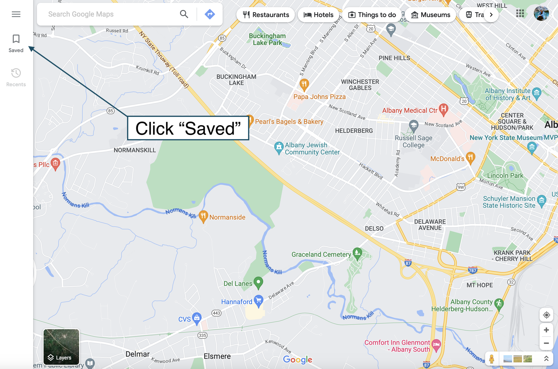
This opens a new blank map. Start by giving your map a title and a description.
Once you’ve named your map, you’re ready to start pinning stops! Keep reading to learn about adding and customizing location pins.
2. ADD LOCATIONS TO YOUR GOOGLE MAP
This is where you start adding the places you want to go!
HOW TO ADD LOCATION PINS
Add multiple stops to your Google map by pinning their locations. There are a few different ways to add location pins to your Google Map :
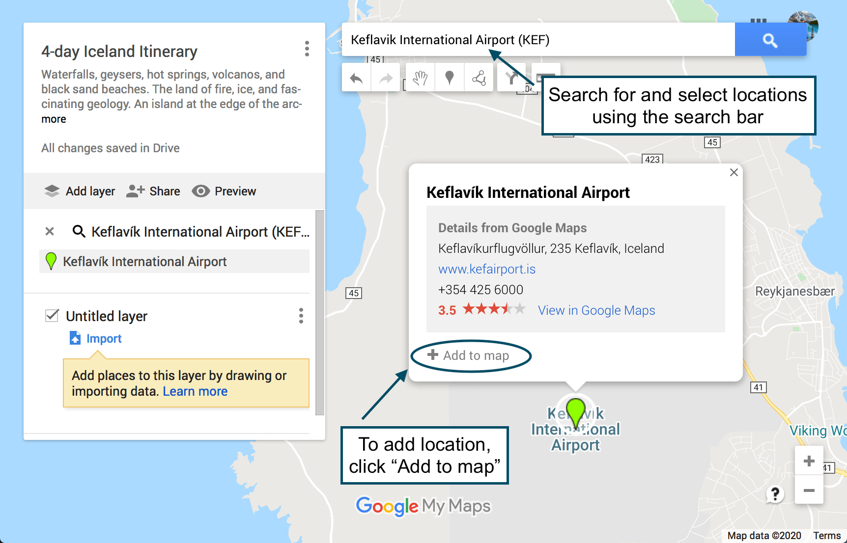
- Add a pin using coordinates if you can’t find the exact location in the search bar drop down list. You may have to use this method for extremely specific or remote locations, such as a backcountry campsite or an unmarked trailhead. Simply type the location’s latitude and longitude coordinates into the search bar. .
- To pin a general area, click on the “Add Marker” button below the map search bar . You’ll be able to drop a blank pin by clicking anywhere on the map. A box will appear asking you to add a title and description
NOTE: You’re allowed to pin 10 location pins per layer. Continue reading to learn how to use layers to add more than 10 location pins to your map.
3. CUSTOMIZING LOCATION PINS
Once you save your pins to the map, they’ll be blue by default. However, you can customize a pin by changing the color, icon style, description, and title . You can even add pictures or videos if you’re feeling extra fancy.
To change the color and style , begin by clicking on your location pin (either in the list to the left or directly on the map) > “Style” (the little paint can) in the lower right hand corner of the text box. Click “More Icons” to view more options.
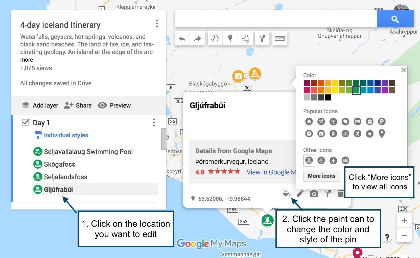
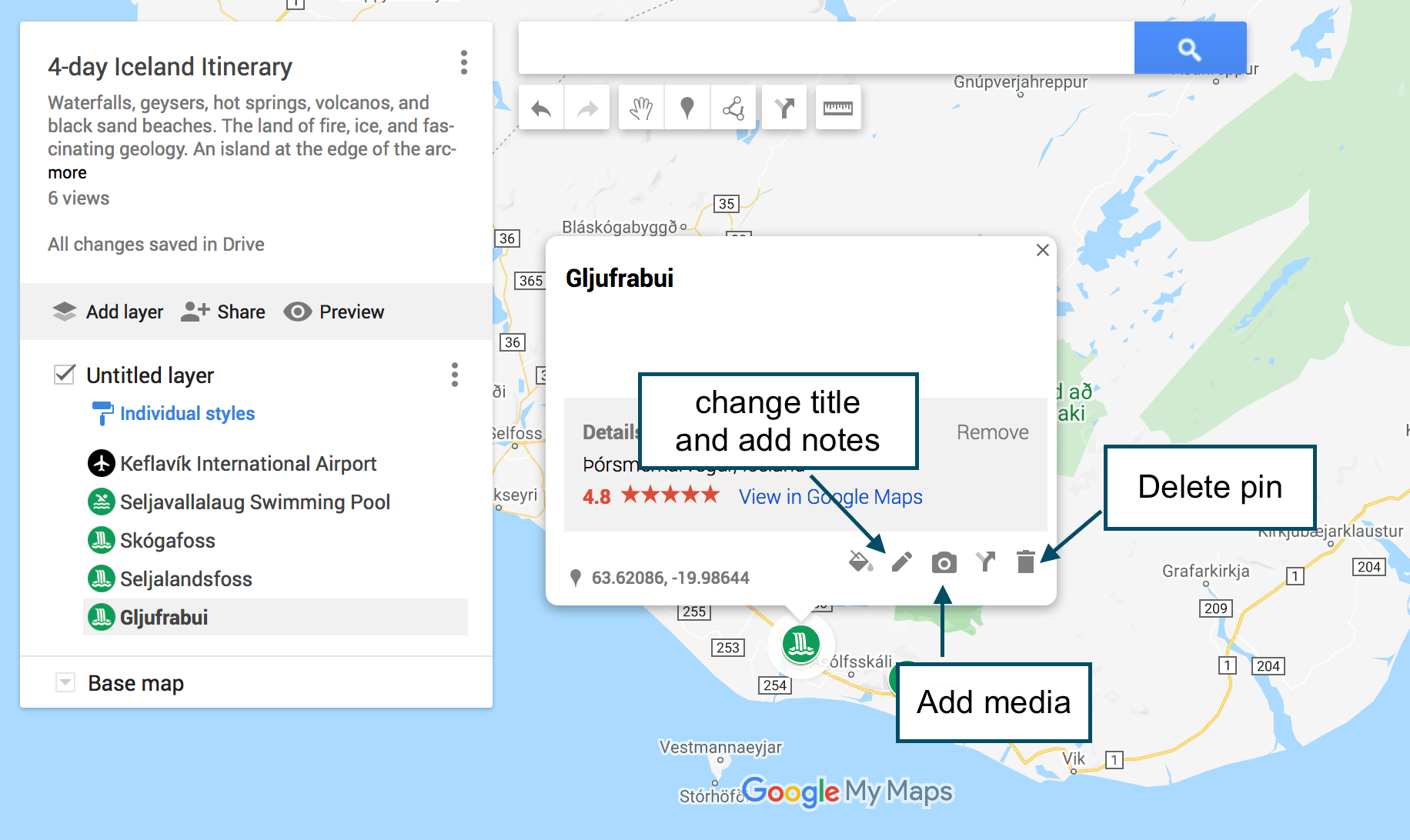
To change the location title , click”Edit” (the pencil icon) in the text box. You can also add notes in the “Notes” box. Use the notes box to add more details about finding trail heads, hiking logistics, packing reminders etc. I also like to use it to keep track of specific places to see within a general location, such as a National Park.
To add media (i.e. photos or videos) , click “Add Image or Video” (the camera icon) in the text box. I found this especially helpful on my first Iceland road trip to remember which waterfall was which, since they all sound the same (if you’ve been there, you know what I mean!). You can also add your own photos and videos if you want to create a map to share with others.
To delete a pin , click on it and then click on the trash can icon. .
. 4. CREATING MAP LAYERS TO PLAN YOUR TRIP IN GOOGLE MAPS
What are google map layers.
Google Map layers are a really useful tool for organizing your road trip itinerary. But, what exactly is a layer? A layer in Google Maps is, by definition, a way to contain arbitrary geospatial data.
Okay, English please ?
In other words, each layer can be used to display different types of information on your map. You can dedicate different layers to different types of places like restaurants, cafe’s, hotels, hiking trails, etc. Or you can dedicate layers to different days of your trip. Or you can stick to one layer. Its up to you.
Here’s an example of how I broke up my Iceland itinerary, using a different layer for each day of our road trip:
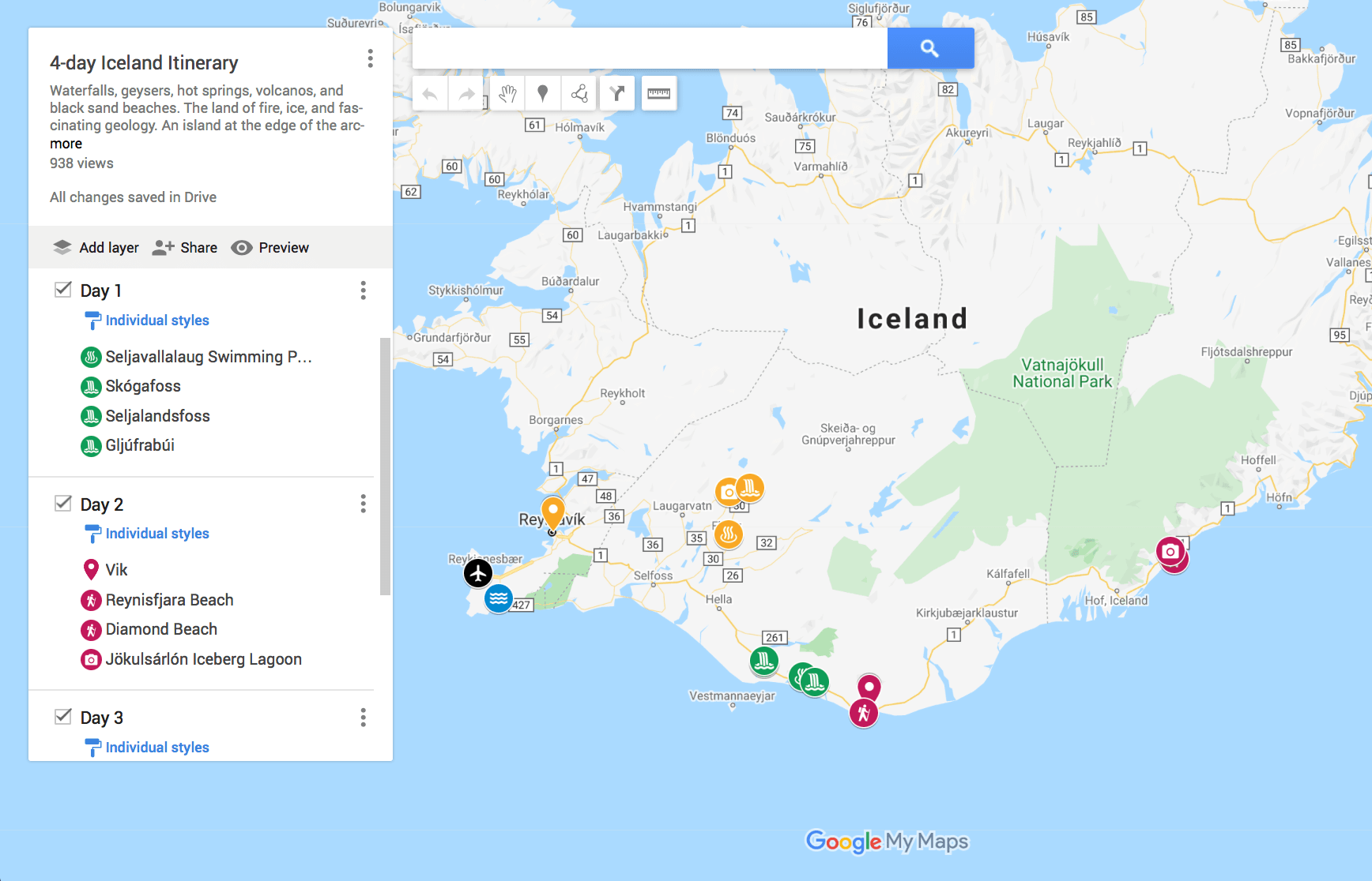
HOW TO ADD LAYERS
When you create your map, you’re automatically using one layer (“Untitled Layer”). This is the layer that your location pins are added to by default, unless you add additional layers. You can add up to 10 location pins per layer, and 10 layers per map.
To add a new layer to your Google Map , simply click “Add Layer”. This creates a new “Untitled Layer”, which you can rename accordingly. To rename layers, click on the title name or click the 3 dots next to the title > “Rename Layer”.
To move a pin between layers , click on the location pin in the list, then drag and drop it into the desired layer.
Choose which layers to display by turning individual layers “on” and “off”. You can do this by checking/unchecking the box next to the layer’s name.
To delete a layer , click the 3 dots next to the layer’s title > “Delete this layer” > “Delete”.
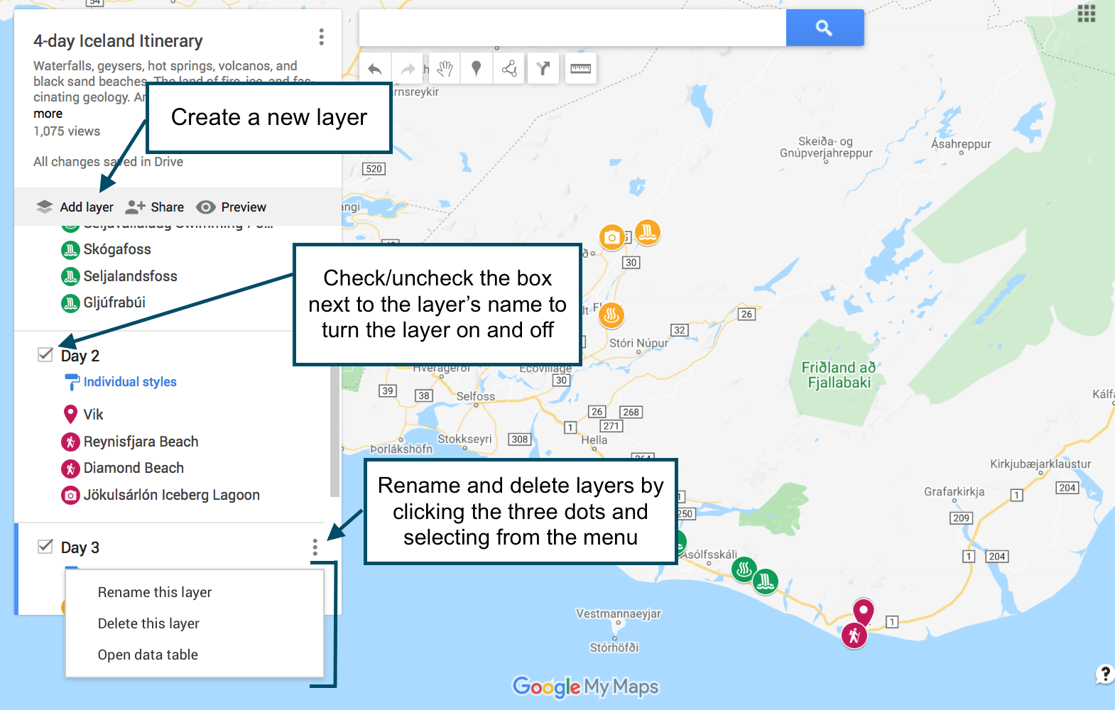
. TIPS FOR USING LAYERS TO PLAN YOUR ITINERARY IN GOOGLE MAPS
When planning my road trip itineraries, I usually give each day its own layer (unless the trip is longer than 10 days, in which case then I’ll combine days or make another map). Then I color code all of my pins by day.
For example, all of my stops (i.e. location pins) on day 1 (layer 1) would be orange, all of my stops on day 2 (layer 2) would be red, and all of my stops on day 3 (layer 3) would be blue. Organizing pins and layers this way makes it a lot easier to visualize your day-to-day itinerary on the map.
That’s just what works for me, so obviously you don’t have to do it that way. You can organize your pins and layers in any way that makes sense to you.
WHEN TO MAKE SEPARATE MAPS
Personally, I prefer to make a single map for my road trip itineraries whenever possible. But that won’t work for everything or for everyone.
Sometimes maps can get confusing if you have a lot of stops to make. Other times you’ll find that you need more than 10 layers or directions between more locations than Google Maps allows.
To solve these problems, you may opt to create several maps. Perhaps you’ll find it easier to create a separate map for each day of your road trip, or create one map dedicated just to a certain type of location or activity.
For example, we created two separate maps for our road trip through New Zealand. One map for the North Island and one map for the South Island.
5. ADDING DIRECTIONS TO YOUR GOOGLE MAP
. What good would a Google Maps itinerary be if you couldn’t get driving directions?
To add driving directions to your Google Map , click on “Add Directions” (the arrow icon) under the search bar. A new layer will appear (you cannot add directions without it adding a new layer).
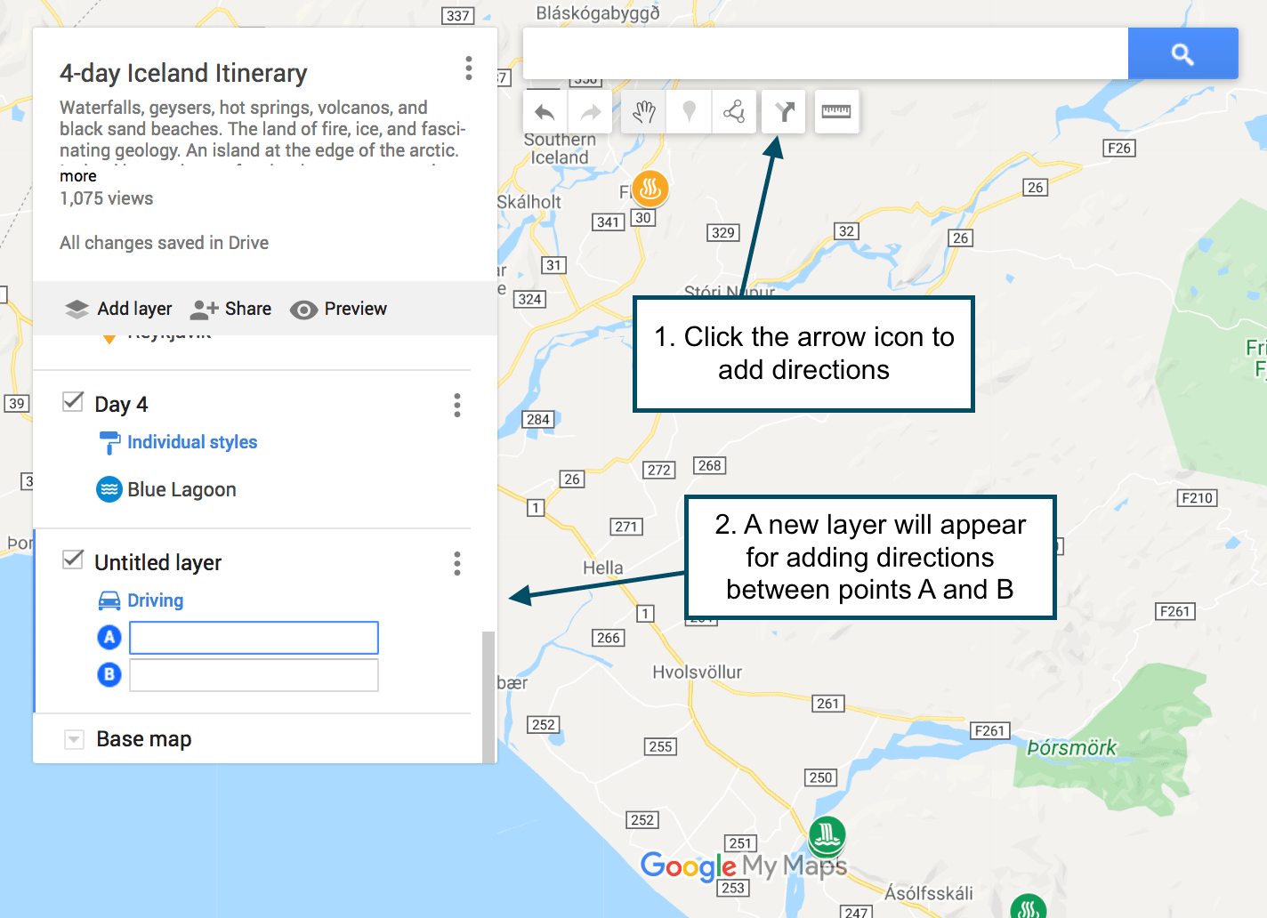
Click on “Add Directions” simply by clicking on a pinned location on the map. It will populate in point “A” . Click on a second location on the map, which will populate in point “B” . The route will show up as a blue line on the map.
The original directions will only give you the option to add points “A” and “B”. To add more destinations, click on “Add destinations”. You can add up to 10 destinations.
NOTE: This may seem obvious, but I’ll say it anyway: When you connect locations, make sure to do it in the order that makes sense. Don’t just add directions between two random locations. Make sure to do it in order!

To choose between driving, walking, or bicycle directions , click on the Directions button in the layer (the blue car icon). Then click on the appropriate mode of transportation.
VIEW STEP-BY-STEP DIRECTIONS
To view step-by-step directions, click the three dots to the right of the little of the directions layer > click “Step-by-step directions”.
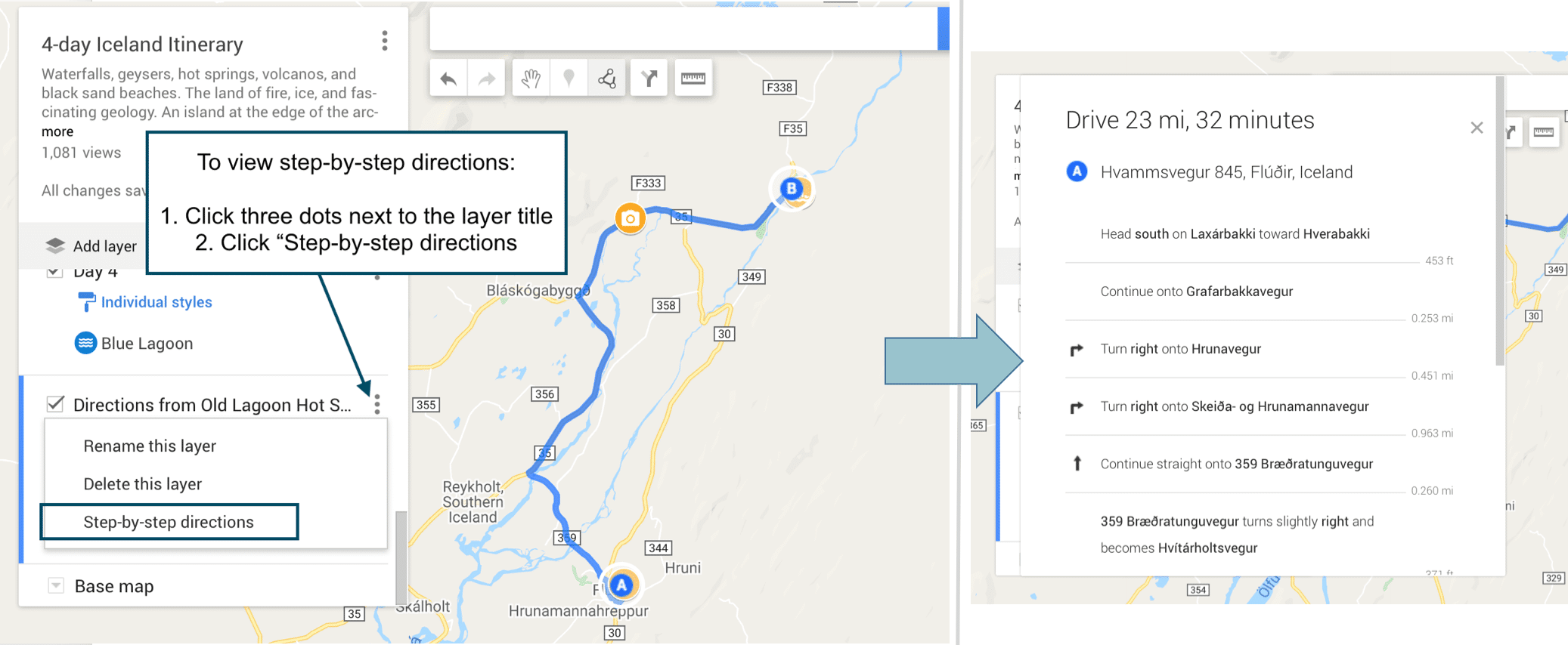
ADJUSTING YOUR ROUTE
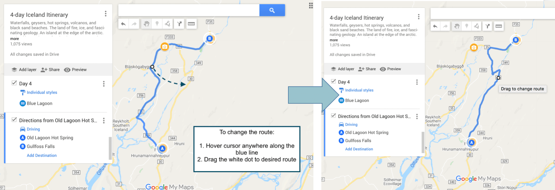
Google maps will automatically calculate the shortest route between locations. But you can easily change the route if you prefer to take a different one (i.e. to take the more scenic route, avoid tolls/highways, etc.).
To adjust the route between two points , hover your cursor anywhere along the blue line. Your cursor will change from a hand to an arrow over a white dot. A dialogue box will say “Drag to change route”. Click and drag the white dot to the desired road or highway on the map.
. 6. HOW TO ACCESS CUSTOM GOOGLE MAPS ON YOUR PHONE
. There are two ways to access your custom Google Maps on your phone. You can (1) reference your map through the Google Maps app or (2) export the entire map for offline access using Maps.me . Which method you use depends on your personal preference.
Steps are the same for iPhone and Android.
1. To view your maps in the Google Maps app:
- You will need to download Google Maps, if you haven’t done it already
- Sign into the same Google Drive account you used to create the map
- Click on the search bar > “…More” > scroll to the right and click “Maps”
- Select your custom map
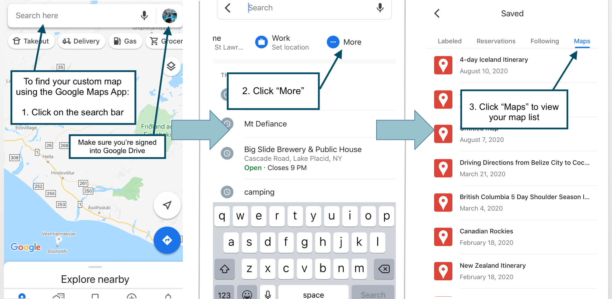
How to view your custom Google Map on your phone using the Google Maps app .
Essential tips for using the Google Maps app:
- Accessing step-by-step directions: When you open your map in the Google Maps app, your directions layer will be visible, but you won’t be able to click on it and get the step-by-step directions. . Instead, navigate to the individual location pins on the map. Click the pin and the directions instruction will populate in the search bar. Click on the search bar and then hit “Search”. This will exit your custom map and open up the regular Google Maps navigation screen. .
- Accessing your map offline: You can’t. There is currently no way to access your custom map offline in the Google Maps app. Which is obviously not ideal if you’re traveling without cell phone service or wifi. . You can download an area for use offline by clicking on your photo (the circle in the upper right corner) > “Offline maps” > “select your own map”. However, when you do this, the map will be blank and you’ll have to repin/save all of your pins. You can repin/save locations by searching for the location > “save” > and then either add to an existing list or create a new list.
2. To export your custom map to Maps.me:
This method is quite a workaround, but (unlike the Google Maps app) it allows you to access your custom map offline without having to repin anything.
On your desktop:
- Open your map on desktop
- Click the 3 dots next to the map title > select “Export to KML” > check the box next to “Export to .KML file instead of .KMZ”.
- Make this file accessible through your phone by uploading it to Dropbox, Google Drive, email, or any other file sharing app.
On your phone:
- Download the Maps.me app
- Search for the city, state, or country your map is based in and then download
- Go to your photo sharing app and open your .KML file with Maps.me
- You’ll be directed to your custom map in Maps.me
Tips for using Maps.me
If you download your map in Maps.me, you’ll be able to use it offline. However, the major drawback is that you will only be able to access step-by-step directions from your current location. So, even though your directions layers will populate on your map, you’ll only be able to view the drive times and not the actual directions, unless one of those points is your current location.
That being said, I am not a Maps.me expert. So, if you have an update or workaround for this issue, please reach out and let me know :)
7. CREATE A SHARED GOOGLE MAP
You might want to share your map if you’re planning a trip with someone else, collaborating on an itinerary, or sharing your map on a website.
To share your Google Map , open the map > click “share” in the gray bar above the layers. Make sure the slider for “Anyone with this link can view” is set to blue. Then copy the link and send it to friends!
To embed your map on a website , check that your sharing sliders are set to “Anyone with this link can view” and “Let others search for and find this map on the internet”. Next, click the menu (the three dots) next to the map title > then click “Embed on my site”. Copy the HTML and paste it in the source code for your page.
8. BONUS: CALCULATE GAS MILEAGE
. Download my customizable Travel Expense Planner below for free . Use it to easily and automatically calculate how much money you’ll spend on gas, using your custom Google Map!
And there you have it! All the tips, tricks, and general instructions on how to use Google Maps as a road trip planning tool . As always, if you have any questions or have anything to add, leave a comment below. I love to hear from you!
Happy adventuring!
Did you find this Google Maps road trip planning tutorial helpful? Don’t forget to pin it for later!
Hi, I’m Jackie! I’m a travel photographer and content creator based near the Adirondack Mountains of Upstate New York. I’m also a millennial who works full-time, yet I still find ways to travel frequently without breaking the bank, because traveling is what makes me feel most alive. Now I help fellow travelers who also work 9-5 and are looking for ways to travel more with limited PTO.
Related Posts

15 Useful Apps to Download Before Your Next Road Trip (for Free!)

All You Need to Know About Renting a Car in Belize | Cost, Tips, FAQs – Updated Guide 2023
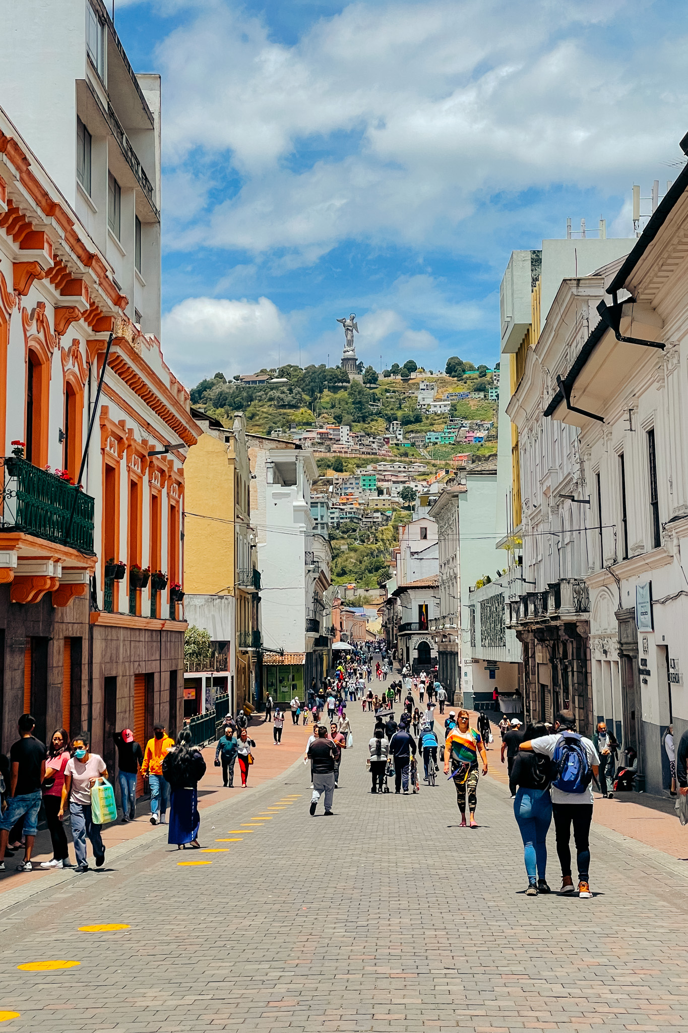
19 Important Things to Know About Ecuador Before You Go
27 comments.
[…] Krawiecki, J. (n.d.). How To Plan Your Road Trip With Google Maps. The Adventure Atlas. Retrieved from How To Plan Your Road Trip With Google Maps (Tutorial With Examples) | The Adventures Atlas […]
[…] that an SUV or an RV is better suited for the whole family. Once you’ve secured your vehicle, map out your route, research the stops that you want to make, and make a list of the things that you’ll need to […]
[…] You won’t have service once you get there though, so I suggest downloading offline Google Maps of the area before you go. To learn how to download offline Google Maps, visit my blog post on How To Plan Your Road Trip Using Google Maps […]
[…] How to Plan Your Road Trip Using Google Maps […]
[…] How to Plan Your Trip Using Google Maps […]
All I needed when I googled “how to plan a trip in google maps” was to be pointed in the right direction of where to look for the feature. This went WAY beyond what I could have ever asked for and helped SO MUCH! Thank you, thank you, thank you!

Hi Nicole – I’m SO glad to hear you found this post helpful!
[…] How to plan a road trip using Google Maps […]
Hello Jackie, and thanks for the very informative article! It was well written and I used Google Maps on my last trip to the Baja in Mexico. One other tool I used was the free trip planner from Geovea https://geovea.com/trip_plan/new_trip to create and share my trip, and estimate my trip budget. You can also take your itinerary with you on your phone for navigation. I really appreciate all of the great travel guides and already planning my next trip :-)
Thank you for sharing all of this valuable information! I see how to view the turn-by-turn directions, but is there a way to start the route so you can follow it while driving? Thanks!!
[…] How to Plan Your Road Trip using Google Maps […]
This literally just changed my life! Thank you for sharing how to use google maps to plan a road trip. I will use this all the time now!
Hey there – so happy to hear you found this post useful!
[…] Planning a Costa Rica road trip? Read: How To Plan Your Road Trip With Google Maps (Tutorial With Examples) […]
[…] a large geographical area you need to give your trip a bit of structure. You can start by using Google Maps to plot and plan your journey so you can make a note of all the destinations you are interested in. You can then agree on a few […]
[…] Read next: How To Plan Your Road Trip With Google Maps (Tutorial With Examples) […]
said no driving directions from point a to point b, so i couldn’t get started. E.G. Badland SD to Mt Rushmore to Custer Nat. Park, I need a little more direction, i’m not to good with comp. thanks
Hey Billy – Sometimes Google Maps won’t recognize directions to very general areas because it wants you to use something more specific. This most often happens with National Parks and wilderness areas. In those cases, Google Maps will generally present you with a list of specific locations you can choose from, such as the park’s ranger stations, visitors centers, etc. However, in your situation, I was able to pull up directions using “Badlands National Park”, “Mount Rushmore National Memorial”, and “Custer National Forest”. Hope that helps!
[…] necessary than you suppose to sleep, bathe and plan for slower days. A very good rule of thumb is to plan in rest time each three days. That method, you possibly can push your self however forestall exhaustion in your […]
[…] essential than you assume to sleep, bathe and plan for slower days. An excellent rule of thumb is to plan in rest time each three days. That means, you possibly can push your self however stop exhaustion in your […]
I’ve been a user of paper maps, since before the Internet, or color TV for that matter. For an up coming trip, basically Texas to FL, and back, I decided to make better use of Google Maps. A google search brought me to this page. Super helpful, and the pins per layer note answered a long standing confusion of mine. Thank you. I do have one question. Is there a way to to add waypoints based on distance or travel time? For example, this is going to be a two day trip. I want to find the halfway point (easily)? Or in the case of a longer trip, I want to drive X miles or Y hours? I know I can trial and error it, but what if I want the half-way point? What’s the easiest way to find it? Or where will I be in 8 hours of driving? Thank so much! Cheers, Eric
Hey Eric – thanks so much for your comment! Unfortunately, I don’t know of an easy way to calculate your half way point or location after x amount of hours. I typically eyeball it, which might be the only way to find your answer
Thanks very much, it is really helpful
This was most helpful for creating a personal map. I tried it and created a practice map on my laptop; named it and accessed it exactly like your instructions indicate. The part that has me puzzled is the accessing it from your phone. I have used Google maps on my phone for a long time and believe I am signed in using the same account. The Google Maps app on the phone identifies me (the right end if the search bar has my initial and shows the account when tapped.) When I tap the search bar I get to the … More but that is it. All I then see is the opportunity to set my Home and Work Locations but no listing of My Maps.
On the laptop going to the Menu (bars at left side of Search) allows access to Lists, Labeled, Visited, and Maps. (Maps is the one, as you indicate, to get to your personal Maps.) On my phone the only thing that seems to be available is the Labeled option. What am I missing to get to the Maps? I feel like there must be a switch somewhere to have the Maps come through … but I can’t seem to find it! Hoping you or someone can point me in the right direction. Thank you.
Without creating a custom map, is there a way to display a route in Google Maps and show attractions at the same time?
You’ve written a terrific guide and I’m learning a lot more about Google maps. Is there some way to print this guide or download a printable copy? Thanks.
Leave A Comment Cancel reply
Save my name, email, and website in this browser for the next time I comment.
WANT TO SAVE MONEY TRAVELING?
Check out the travel resources →
Check out my list of reliable budget-friendly travel resources that are guaranteed to save you the most money, without compromising your experience.
This error message is only visible to WordPress admins Error: There is no connected account for the user 17841400792270379.
Get in touch
Contact Portfolio Let’s work together
Explore the blog
Destinations Guides and itineraries Travel planning tips
Let’s connect
Never miss an adventure, privacy policy | terms of service | disclaimer | by zazen designs.
Back to top
How to use Google Maps as a trip planner and make a full itinerary
- You can use Google Maps as a trip planner through the "Places" and "My Maps" features.
- Both the Google Maps website and app let you save locations to lists, which you can then get immediate directions to.
- When getting directions, you can look up reviews and add multiple stops to your route.
Google Maps has become an essential part of any road trip. After all, it's a GPS, business directory, and reviews platform all-in-one.
But if you spend some time with it, you can integrate Google Maps even more seamlessly into your next vacation. Google Maps has a variety of features you can use to plan your trip and save any interesting spots you find on the way.
Here's how to make Google Maps your trip planner, using the Places feature, My Maps, and more.
How to use Google Maps as a trip planner
Use the 'places' feature to save points of interest.
Let's say you're traveling, and happen to stumble upon the cutest coffee shop you've ever seen. You want to visit, but don't have time right now — what's the best way to remember it?
Google Maps' Places feature can help you out. Both the Google Maps website and app let you save any location on the map to a list, which you can then easily find later.
1. Open Google Maps and click, tap, or search for the location that you want to save.
2. Find the Save icon , which has the icon of a bookmark. You'll find it right under the location's name, but you might need to swipe to find it in the mobile app.
3. Pick where you want to save the location to. You've got three lists to start with — Favorites , Starred places , and Want to go — but you can make a new one by tapping New list .
4. Once you've saved the location, you can find it again by opening the list. In the mobile app, tap Saved at the bottom of the screen; on the website, click the three stacked lines in the top-left and then Your places .
Tap on a location in your list to have the map jump straight to it.
Look at Google Reviews to find the best shops
Nearly every point of interest on Google Maps has a section for user reviews. Similar to sites like Yelp, these reviews can be a great way to see which stops are must-sees and which you can pass.
To check out reviews:
1. Open Google Maps and find the location that you're interested in.
2. At the top of its information page should be a star rating and a number, showing how many people have left reviews.
3. Scroll down until you hit the Reviews section, and you'll find reviews from other users who've visited the location. They'll include a star rating, a date, and occasionally a picture.
If you're interested in leaving a review of your own, check out our article on how to write Google reviews .
Make a custom My Maps page to share your road trip plan
Only available on a computer as of this month , Google's My Maps program lets you make a custom map or plot out a route with as many waypoints as you like, and then save and share it with others.
1. Head to the My Maps homepage and click Create a New Map .
2. You'll be given a world map. In the menu in the top-left, click the Untitled map name to give your map a name.
3. Use the search bar at the top of the page to find any location, then click Add to map to save it. You can add as many points of interest as you like.
4. You can also save multiple separate lists of locations to the same map; just click Add layer in the top-left menu.
5. To save directions between multiple locations, click the Add directions icon that looks like a curved arrow. It'll add a new layer that you can use to plot a path.
6. When you're done, click Share or Preview in the top-left window.
Add multiple stops to one trip
Driving from one city to another is simple. But if you want to make stops along the way — lunch, the beach, a mall — things get complicated.
Luckily, you don't need to start a new Google Maps route for every stop. You can create one navigation route that includes every stop from the start, giving you a clear way to see how long it'll all take.
1. Open the Google Maps app and start navigating to another location.
2. On the screen that lets you pick your starting and ending location, tap the three dot icon .
3. Select Add stop .
4. A third waypoint — labeled "B" — will appear. Tap it to choose your second destination, or drag it to reorder the waypoints.
On a computer
1. On the Google Maps app website, find a location and start getting directions to it.
2. Underneath the menu that lets you pick your starting and ending location, click Add destination .
3. A new field will appear. Enter your third waypoint.
4. Once you pick a new waypoint, you'll be able to click Add destination again and pick another one, as well as reorder them.
You can add up to nine destinations on both the website and mobile app.
On February 28, Axel Springer, Business Insider's parent company, joined 31 other media groups and filed a $2.3 billion suit against Google in Dutch court, alleging losses suffered due to the company's advertising practices.
- Main content
Visit global landmarks with photo tours in Google Maps
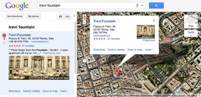
No comments :
Post a comment.
Note: Only a member of this blog may post a comment.
- #streetview
- #treasuremap
- Adwords Express
- Art Project
- Business Photos
- Business View
- competition
- crisis response
- custom maps
- disaster response
- earth outreach
- Emmy Awards
- Fusion Tables
- Google Earth
- Google Earth Engine
- Google Map Maker
- Google Maps
- Google Maps API
- Google Maps Engine
- Google Maps for Mobile
- Google Maps Gallery
- Google Maps Navigation
- Google Maps Transit
- Google Places
- Google Plus
- Google Search
- Google Street View
- Grand Canyon
- ground truth
- Indoor Maps
- Making of Maps
- Mall of America
- Maps Gallery
- Matt Harding
- National Geographic
- new Google Maps
- oblique imagery
- offline maps
- Parks Canada
- Photo Spheres
- photo tours
- Polar Bears
- real estate
- restaurants
- Santa Tracker
- search stories
- South Sudan
- Street View
- Thomas Jefferson
- Thomas Jefferson Foundation
- Tip of the week
- U.S. National Park Service
- University of Virginia
- Valentine's Day
- Veterans Day
- voice search
- Your Timeline
Company-wide
- Official Google Blog
- Public Policy Blog
- Student Blog
- Android Blog
- Chrome Blog
- Developers Blog
- Ads Developer Blog
- Android Developers Blog

HOW TO USE GOOGLE MAPS TRIP PLANNER IN 7 STEPS

Google Maps Trip Planner allows you to create detailed travel plans while simplifying those confusing things related to travel planning.
Planning a trip often seems like trying to put together a million-piece puzzle. It is understandable that a trip to a place that we’ve only ever seen through a laptop screen can be confusing.
But it won’t be that way when you start planning a trip on google maps.
Most of the confusion related to travel planning is because we have no sense of orientation for that place or destination that we’re about to visit. All we have is a bunch of ideas – places we want to go and see, hotels we like, activities, but we have no idea where those things are located.
Creating a trip plan on google maps puts everything into perspective because it gives you a visualization of those things on a map.
When you have those ideas clearly pointed out on an organized google maps travel plan, it will be easier to choose the area you want to stay (and eliminate the surprise of booking a hotel in the middle of nowhere) , group together certain activities in a practical way and you can also plan a route in google maps for your daily itinerary.
Basically, planning a trip on google maps will make travel planning a whole lot easier. And best of all, it’s free and pretty simple to use.
Before we start, you may want to save the URL link to this post in case you need it for future reference.
Ok then let’s get right to it.
If you want to know something specific about creating a travel plan in google maps you can skip straight to what you want in the table of contents below.

1. CREATE A NEW GOOGLE MAP
2. add all your ideas to google maps, 3. changing the pins colors and icons, 4. categories a google maps travel plan, 5. access you google maps travel plan on mobile, 6. use maps offline, 7. share map with friends.
Do this if you’re soon going on vacation or planning a trip.
Before you go on vacation make sure to purchase travel insurance. I know, most times it seems like a waste of money. But the thing is, you don’t know you need it until you do so it’s good to minimize those risks that you could face while traveling. Keep in mind, that medical bills or hospitalization can cost 1000’s of $$. And
CLICK HERE FOR A FULL RUNDOWN ON TRAVEL INSURANCE STARTING AT JUST $1.50
In this guide, we are laying out a step-by-step guide to create a travel plan using google maps on desktop (laptop). Although it is possible to create a map on your smartphone, the options are limited. But don’t worry, the map created on your desktop will be synced to all your devices, even mobile phones and tablets.
If you already have a Google account (Gmail), go onto your search engine (Google, or whatever you usually use) and type in google maps. Or you can click here to get started.
You will need a google account so that your maps will be saved and also so the maps that you create can be accessed from all your devices like mobile phones and tablets.
If you don’t have a Google account click on this link to create one. Don’t worry it’s free and only takes about 5 minutes. Once you’ve created an account you follow the same steps from above.
Make sure that you’re logged in before you start creating a new google maps trip plan. If you’re logged in there should be a round icon with your initials on it in the top right corner of the screen. If there isn’t you’ll see a sign-in button.
After signing in, first go to the hamburger icon near the search bar on the map. It’s in the top left corner. And then click on your places, the first option in the drop-down menu.

In the menu click on MAPS , the last option on the right. This is where all the maps that you create are saved. So, if this is the first time that you’re creating a google map, this section should be empty.
At the bottom of the current menu, click on CREATE MAP .
Ok then, great the map has now been created.
All you need to do now is to give your new google maps a title and a description. If you only have one map, you barely need a title let alone a description. But as you create more maps, those titles and descriptions will help you easily find the map you’re looking for rather than searching through a bunch of unorganized maps.
In the menu in the top left corner of the screen, Click on Untitled Map . And in the text box that pops up, give your map a title. Think of giving specific names to your maps. For instance, if you’re making a map of New York, instead of just writing a title “New York”, write “New York Trip – October 2021”. And write a description, like places I have to visit, or the best hotels, restaurants, activities, for example.

Not everyone follows the same steps to create their personal travel plan on google maps. For example, our favorite way is to start off by putting all our ideas on the map.
We start off by making a list of places that we want to go, activities that we want to do, hotels and restaurants we like, and anything else that comes to mind that we could possibly consider while in that destination.
Because you can visualize Adding all our ideas onto a map offers a visualization of that destination and puts everything into perspective. For instance, if certain activities are too far away we can determine
For instance, we can easily understand if an activity is too far away or maybe choose a hotel that is centrally located in the middle of the things that we want to do.
Seeing all those places on a map will help you understand what you can realistically do within your trip duration. For instance, you will be able to determine if certain activities are too far away. Or if a hotel you like is in the middle of nowhere.
Adding all those ideas to the map is straightforward.
Step. 1. Go to the search box in the middle of the screen and type in the name of the place. You can search for anything you want, like hotels, restaurants, beaches, waterfalls, parks. Basically, on google maps you’ll find almost every place you look for. If that place doesn’t come up in the search, you’ll need to type in the street address.
Step. 2. Once you’ve found the place you want, a green will come on the map in the location of that place. And a small description box will be next to it.
Step. 3. To save that place to the map, click +add to map in the description box.
Repeat these 3 steps for all those places that you want to add on you new Google Map travel plan.

TIP: if only the green pin comes on the map, click on the green pin. When you click on the pin the description box will come up and you can add that place to the map.
Too many ideas but not much time? When we plan short trips, sometimes we book tours or at least we book a tour if they’re any good. Tours save us time because they combine the must visit spots in the destination we visit. And surprisingly, some tours have cost us less than if we did everything by ourselves.
Whenever we are considering a tour in a popular destination, we always make sure to book with a reputable company and also to book in advance. Because you know, the good things easily run out. Below are links of 2 companies that we personally use.
PRE BOOK & GET THE LATEST DEALS WITH VIATOR HERE
OR PREBOOK WITH KLOOK FOR THE BEST DEALS ON TOURS & TICKETS IN ASIA
At this point, we have a good idea of where all those places – like activities, tourist spots, hotels, restaurants – are located. And by default, all the pins will be in blue color.
But having a load of identical pins isn’t a great way to visualize a google maps travel itinerary.
So now, what we need to do is to give meaning to each pin by color coding and/or changing the pins into icons.
Color coding the pins or changing them into different icons will make your google map a lot more visually understandable.
For example, what we do is color code each place into different categories. For example, if we have beaches we make yellow pins, for hikes we use brown pins, for restaurants red pins, and so on.
And we also customize the icons. Don’t worry, both color and icons are pretty straightforward.
How to color code pins in google maps
Step 1. Click on the pin that you want to change the color. A description box will open up.
Step 2. Next click on the style, the icon resembling a tipping paint bucket. The first icon at the bottom of the description box.

Step 3. A small window with color samples will open. Choose a color that will help you easily identify that specific place.
How to change pins to specific icons
Changing those identical pins into icons that actually mean something will further help you visualize what those places are on your google maps trip planner.
For instance, if you have a beach add a palm tree or an umbrella. If you have a restaurant, add a knife and fork icon.
Color coding and icons work simultaneously. So don’t worry, you don’t need to choose either the icon OR the color.
To change icons follow steps 1 and 2 from above. When the window with color samples opens, there will also be a number of icons to choose from. However, you can further expand that icon window by clicking on more icons.
TIP: alternatively you can change color or icons of pins when you’re adding your ideas to the map. After you click +add to map
Adding layers in google maps trip planner is a key feature because it allows you to categories your trip itinerary into different sections.
Creating different layers is a way of grouping together certain things on the map. Because although you may have defined all the pins with specific colors, the map still doesn’t have much organization. It’s like having a bunch of pins with not much value.
The way in which you group together the pins will depend entirely on your choice and also on what is the purpose of the google maps that you’re creating. We’ll give a few ideas on how you could categories all those pins.
We group together our pins in 3 ways, depending on what makes the most sense for that specific travel plan.
If we want an easy to follow travel itinerary, we group together pins in days. So if a number of things can be done in a day, we group those together and call that a day plan.
Or, when we go to countries made up of loads islands like Indonesia or the Philippines, we categories all the pins by islands.
Or, we create a different layer for each different type of place that we want to visit. For instance, we make categories for hotels, restaurants, malls, historical places, activities, etc.

How to add layers on a google maps travel plan
Step 1. In the menu, in the top left corner, click on add layer. You can add up to 10 different layers.

Step 2. Categorize each layer with a title. Click on Untitled layer . A text box will open up and here you can write the title for that layer. If you don’t see the text box, click again until it comes on the screen.

Step 3. All the places that you had previously added to the map will be in the first layer. Once you’ve created different layers, all you need to do is to click on the place you want to move and drag it into the layer/category that you want.
Make sure the box next to each layer is ticked. If next to the layer title there is no tick, it means that layer is closed and you won’t be able to see the things in that layer when use the map on your mobile phone.
Now that you’ve created your Google Maps travel plan you will need to be able to access that plan easily with your mobile phone.
To access your plan on mobile phone go to google maps (make sure you go to google maps and not maps go) and click on saved at the bottom of your screen.
In the next window scroll all the way down and click on maps on the bottom right side of the screen. This is where the maps you create are saved.
Now choose the map you and click on it.
Now you can access your google maps travel plan when offline. And also use google maps to get directions even if you don’t have a connection.
So from now on it won’t really matter if you’re connected to the internet or not. You can easily find google maps travel plans and get directions even in remote places with unreliable wifi service.
You’ll need to plan these things ahead because the only way to access your maps or get directions is to download what you need in advance.
I will explain exactly how to download google maps for directions and how to download your google maps trip planner.
Accessing Google Maps travel plan offline
- Download Google Earth App on your mobile phone.
- Go to your google maps travel plan on desktop and click on the 3 dots next to the title.
- In the pop up box click export to KML/KMZ. In the next pop up leave the boxes unchecked and click download.
- Send a downloaded copy to yourself by email.
- Now, on your phone go to that email, click on the file and open it with Google earth.

And follow these steps to use Google directional maps offline
- On your mobile phone, open the google maps app. Be sure the app is Google Maps and not “Google Maps Go”.If you haven’t got the app on your mobile phone you can download it here.
- In the top right corner of your mobile screen you will see a round icon. Click on the icon to access your account and go to offline maps.
- On the next page click “select your map”. This will open the page where you download your map. By default, the area of the map will be of your location. However, you can scroll to find whichever part of the world you want to download.
Keep in mind that for google to work offline you need to download the map over a connection. By default, maps will only download over wifi connections. If you want to include mobile data for downloads head to the settings wheel on the “select your own map” page and go to download preferences.
Whether you are planning a trip with google maps or not you should always share your travel plan with someone you trust.
Especially if you’re traveling solo, someone should always know what your plans are. At least, if something happens in those places you’re going to visit someone will know where you are.
Besides safety reasons, you can also share your google maps and let friends or your travel buddies contribute and give their own input on things they want to do.
Follow the steps below to share your google maps travel plan:
- To share from desktop go to the map you want to share and under the main title click on the share button. In the pop up window click the button next to “anyone with this link can view”. Copy the link and share it either by email or message.
- To share on mobile open google maps mobile app, click saved at the bottom of the screen. In the next window scroll all the way down and click on maps. Open the map you want to share and click on “view map legend”. Click the share option and choose how and to who you want to share that google maps travel plan.
Sharing your map will give your loved ones some peace of mind. At least, if they don’t hear from you they will know where you were at that time.
Using google maps to create detailed travel plans takes out a lot of the unnecessary stress of travel planning. It also makes a travel plan organized and easy to understand because of the visual aspect of planning a trip on a map.
So I hope this article gives you a better understanding of how to plan a trip with google maps. But if you have any other ideas or alternate ideas on certain things we mentioned please let us know in the comments below. There is no better way to improve than to get ideas from other travelers.
Our love for travel started off in South East Asia and continues to attract us each year. If you want you can read a bunch of interesting articles about beaches, waterfalls, food, itineraries by clicking the link below.
CLICK HERE TO READ A BUNCH OF INTERESTING ARTICLES!!
Do you want to know useful travel tips without even searching?
Subscribe to our email list to receive tips and detailed itineraries for amazing places around the world that will spark your travel inspiration.
Your Name (required)
Your Email (required)
Follow Us On Pinterest .
2 thoughts on “HOW TO USE GOOGLE MAPS TRIP PLANNER IN 7 STEPS”
The articles you write help me a lot and I like the topic
I like this. I posted this on my LinkedIn and my followers enjoyed it! Keep up the good work. 🙂
Leave a Comment Cancel reply
Save my name, email, and website in this browser for the next time I comment.
——— ABOUT US ———

We're Jackie and James, now in our late 30's, we've been traveling on and off for 5 years now. After living our entire lives on a tiny island named Malta, we set off to explore Asia on a budget while writing detailed guides about awesome destinations. We hope our travels help you realize that traveling doesn't have to cost a fortune.
——— SEARCH THE BLOG ———
Recommended

Travel Packing Methods – X6 Packing Organization Tips
Read More->

HOW TO PLAN A TRIP – 10 STEP TRAVEL PLANNER GUIDE

TRAVEL SAFETY – 27 TIPS TO STAY SAFE WHEN TRAVELING

CHOOSING THE BEST LONG TERM TRAVEL INSURANCE POLICY IN 2021

CHOOSING A HOLIDAY DESTINATION – 7 STEPS TO FIND THE BEST VACATION SPOT
- Join Us for: ◆ Arival 360 | San Diego 2024, 30 Sep - 3 Oct 2024 ◆ Arival | Activate Edinburgh, 23-25 Nov 2024 ◆ Arival 360 | Valencia 2025, 28-30 Apr 2025
- 30 Sep - 3 Oct 2024 Arival 360 | San Diego 2024 23-25 Nov 2024 Arival | Activate Edinburgh 2024 28-30 April 2025 Arival 360 | Valencia 2025
- All Events >
- Insider Pro Meetup | A Job Well Done – Get Started Selling Corporate Tours US & Europe Traveler Trends Webinar: Insights for a Successful Summer Innovation Showcase @ Arival 360 | Berlin 2024 The Attractions Forum @ Arival 360 | Berlin 2024 Arival 360 | Berlin 2024 Insider Pro Meetup - Strategies to Scale
- Arival Spotlight Awards
- Arival TourReview Spotlight Awards
- Introducing Spotlight Awards
- TOURREVIEW SPOTLIGHT WINNERS ORLANDO 2023
- METHODOLOGY
- TOURREVIEW SPOTLIGHT AWARDS FAQS
- Arival Spotlight Winners
- Arival Spotlight Submissions
- Spotlight FAQ
ARIVAL 360 | SAN DIEGO
30 september – 3 october 2024.
Insider Pro Access Members save 20%
THE event of the year for solutions-focused in-destination experience creators and sellers
Save up to $660 with the Spring Savings ticket
- Guest Communication for Innovation Showcase Win 5 Ways Experience Businesses Are Using AI Today Tour Guide Training: The Best Tips & Tools for Your Guides Take Part in Our Global Operator Survey
- Distribution
- Operator Stories
ARIVAL | ACTIVATE EDINBURGH 2024
23-25 NOVEMBER 2024
THE event of the year for the European in-destination experiences industry
Save up to £440 with the Super Early Bird ticket
- AI in Experiences: Case Studies in Emerging Tech Arival Guide to AI in Experiences The Power of Events: How Sports and Performing Arts Drive Tourism The 2024 U.S. Tour Taker
- The Outdoor Adventure & Activities Traveler REPORT SERIES: The 2024 U.S. Experiences Traveler
- Search All >

ARIVAL 360 | VALENCIA
28-30 april 2025, save up to €910 with the super early bird ticket.
- Marketing with Google
- Culinary Experiences Guide
- Arival Booking System Guide
- How to Choose a Booking System | CHECKLISTS
- Insider Pro Access membership
- Insider Free membership
- Special Offers
- Arival ProShield Insurance
- Employers Dashboard
- Job Board – Post A Job
- Search Our Talent Pool
- Job Seeker Dashboard
- Join Our Talent Pool
- Job Resources
- Tour Guides & Directors
- In-destination Specialty Career
- Marketing & PR
- Operations & Logistics
- Water & Theme Parks
- All Job Categories >
- Join Arival Insiders Free
- Subscriptions
- Group Subscriptions
- Members FAQ
Travelers Can Now Find Tours Through Google Maps: Will They Find You?
With the recent addition of “Experiences” to Google Maps, we revisit Things to do with an up-to-date walkthrough for operators and suppliers of tours, activities and attractions
by Janelle Visser | 19 April 2023
PARTNER POST | SPONSORED by Magpie

Guided experiences are now available on Google Maps, in addition to attractions tickets, with the latest update to Google Things to do.
Google is constantly experimenting with and evolving the way its “Things to do” module looks and works. Since launching Things to do in 2021, and launching it into Google Maps in 2022, there have been multiple iterations of the attraction and experience booking arm of Google Travel.
So where are we at with Google Things to do now, what does it mean for operators, and how can you optimize your listings to take the most advantage of the opportunity? In an upcoming Arival | Elevate session on Google Things to do session, Christian Watts from Magpie Travel will walk us through a few of the top need-to-knows for operators and suppliers of tours, activities, attractions and experiences. Here’s a preview video from Watts, followed by some key Google Things to do need-to-knows below.
What is Google Things to do?
Google Things to do is the tours, activities, attractions and experiences arm of Google Travel: in other words, Google’s window into the Best Part of Travel, the in-destination industry. It’s essentially the way Google displays search results for everything that people want to do when they get to a destination.
Most importantly, for operators and suppliers of tours, activities, attractions and experiences — or things to do — it’s essential to getting found by travelers using Google to plan their trips… and it’s free. While there are paid ad options, product listings themselves are free, and when a user clicks on your listing they are brought directly to your website.
“Google is always trying to find the right way to display the information for people,” explains Watts, “it’s a constant test, there’s new things coming out all the time.”
How does Google Things to do work?
Currently, there are multiple display surfaces where users can find things to do on Google, as Watts explains. Searching for a POI (point of interest) such as the Eiffel Tower will bring up an “admissions” section which lists tickets, and an “experiences” section which lists tours that include the Eiffel Tower as part of the tour. Searching for a location will also bring up POI options, and general travel-related searches may bring up a “Tickets & Tours” ad carousel.
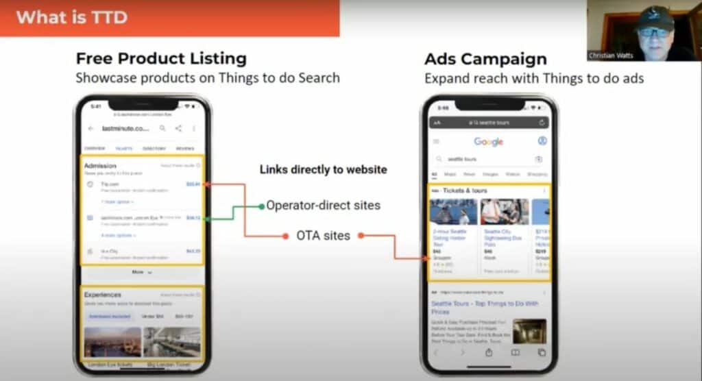
The most recent update is to Google Maps, which as of August 2022 began displaying tickets for attractions , and now is also displaying experiences, which is potentially huge for traffic for tour operators, as Watts observes.
Insider Pro Access Members Save 20%
THE event of the year for solutions-focused In-Destination Experience creators and sellers
How do I get my products listed on Google Things to do?
To get your products listed on Google Things to do, you can use a connectivity partner such as an online travel agency (OTA), reservation system or independent connectivity provider, or by using Google’s self-service editing tool launched in October 2022 for attractions.
In the walkthrough video above, Watts explains the different types of connectivity partners, demonstrates the process of loading up a product listing using Magpie’s interface, and some important questions to ask your connectivity partner.
While Google does offer a self-service tool, at Arival 360 | Berlin Google’s Director of Product Management overseeing Things to do, Emmanuel Marot explained the benefit of using a connectivity partner: “If you have many different product, then it becomes more complicated,” he explains, especially for larger operators who would need to upload and edit each product manually. “And of course one benefit of a connectivity partner is [they] would also push this inventory to other places in Google.” (Insider Pro Access members can watch Marot’s full session here .)

How do I optimize my product listings for Google Things to do?
As with tour descriptions on your own website, you can optimize your product listings on Google to maximize traffic. Watts recommends thinking of it like managing your SEO: keep the content fresh, use great images, monitor your placement and competitors.
In addition, multiple factors specific to Things to do will help with product listing optimization: be sure to fill in all of the requested content fields, ensure your prices are accurate and include all fees, and for tours in particular, add all relevant POIs (up to 100) to ensure your tours appear in as many places as possible.
“Most importantly like with anything Google,” advises Watts, “do the right things. Think of users first, so give the users the information — true information. Don’t try to hack it, don’t come up with some weird thing where you’re doing different prices and then it changes at checkout, give them the best information, correct information.”
Do I actually need to do Google Things to do?
“Do you need this? Yes, you need this now,” concludes Watts. “The OTAs have been doing this for months, they’re getting tons of bookings through this… other people are going to get the business indirectly if you don’t want to do it yourself.
“This is a place where you can compete directly with [OTAs], they have no advantage over your products that are submitted,” continues Watts, “and your competitors are also doing it so it is something you need to jump on now, it’s only going to get more important.”
To learn more about Google Things to do, join the Arival | Elevate consultation seminar for Insider Pro Access members on Wednesday, April 26, 2023 at 11-11:30am EDT/5-5:30pm CET.
Also, get it directly from the source at Arival Activate | Bangkok 2023 in June, where a team from Google will be leading a session on Things to do for operators and suppliers of tours, activities and attractions.
Become an Insider Pro Access member today and get access to the full library of Arival research, plus many other benefits such as free consulting sessions, special discounts and 20% off in-person events, starting from $179 per year.
Sign up to receive insights tailored for the in-destination industry as well as updates on Arival.

Guest Communication for Innovation Showcase Win

5 Ways Experience Businesses Are Using AI Today

Take Part in Our Global Operator Survey

Viator’s Ben Drew Reflects on Leadership Journey
Already a member.
Username or Email
Remember me
Lost your password?
NEED TO REGISTER?
Included in Free Membership
Included in Arival Pro Membership
The Arival on-demand video library archive Access to the entire library of over 150 video sessions and webinars
Arival.guides Short, digestible research & trends reports delivering insights into our industry, such as The Tour Operator Outlook for 2021.
Arival.travel articles Topical articles about marketing, tech, operator business and operator stories in all areas of tours, activities & attractions & experiences
Job board access Find a job from our regular listings, post a resume to the talent network and learn strategies from the job resources articles
New webinars Helpful, instructional sessions covering subjects such as Mastering Facebook Ads, Grow Your Business and How To Work With OTAs — topics to help advance your business.
Discounts on all Arival in-person events 20% Discount on all Arival in-person events (save up to $300)* based on business type
Arival ProShield – Insurance program Access to tailored insurance solutions by Granite Insurance is available exclusively for Arival Insider Pro Access Members. Insider Pro Access Members also have access to a suite of resources from Granite Insurance including templates, forms and other informative documents.
Insiders Pro Access member exclusive webinars Paid membership-only webinars to deepen your understanding of important industry topics.
Job postings & talent directory Post jobs & connect with candidates most applicable to your business.
Private roundtables to connect, learn and engage Small, focused and intimate discussions exclusive to Arival Insider Pro Access members.
Full access to Arival’s library of in-depth reports Up to date, deep analysis of tourism topics ranging from Self-guided Tours to Sales & Distribution Trends and Outlooks, based on the data that defines the industry.
The latest on-demand videos Over 350+ on-demand videos featuring hot topics in tours, activities & attractions
Insider discounts in digital marketing, tech, e-learning, and more Save money on additional tools, services and learnings you need to run your business. Exclusive to paid members.

At Arival, we believe travel can make the world a better place. Our mission is to establish and inspire a diverse community of individuals and companies in the In-destination Industry by providing opportunities to gain insight, share knowledge and build connections. To make it possible for true collaboration, creativity, innovation, and idea exchange to thrive, we are committed to facilitating a welcoming and respectful community for all. This Conference Code of Conduct shares our community expectations and applies to all attendees, employees, exhibitors, speakers, sponsors, volunteers, and other participants at Arival- produced and sponsored events. We empower all participants in our community to actively engage in creating a friendly, inclusive and safe environment for all.
Arival’s core values include the following, and create an expectation for conduct at our events and in online community spaces:
We demonstrate a deep respect for human beings inside and outside our company and for the communities in which they live. We value integrity and strive to consistently interact with others in ways that are authentic, ethical, and fair. We are dedicated to transparency , committing to clear, open and honest communication. We actively pursue and advocate for inclusion, diversity and representation of varying cultural backgrounds, perspectives and ideas
Arival welcomes people from all cultural backgrounds, and does not discriminate on the basis of race, color, creed, gender (including pregnancy, perceived pregnancy, childbirth, breastfeeding, or related medical conditions), gender identity, religion (including religious dress and grooming), marital status, domestic partner status, genetic information, age, national origin or ancestry, military or veteran status, sexual orientation, physical or mental disability, or any other basis protected by federal, state, or local laws.
Accordingly, participants must refrain from displaying any demeaning, harassing, aggressive, or intimidating behavior or materials that would interfere with others’ experience and participation in our community.
If you witness or are subjected to inappropriate or disruptive behavior or have any other concerns, notify an Arival staff member as soon as possible.
Inappropriate or disruptive behavior will not be tolerated. Arival reserves the right to refuse entry to or remove any party from any event or community space at any time when participation or behavior create a disruption or hinder the event or enjoyment of the event by other participants. All determinations are at the sole discretion of Arival, and the decision of the Arival team will be final. Severe breaches of this Conference Code of Conduct may result in disqualification from participating in future events. Individuals expelled due to violating this Conference Code of Conduct will not be eligible for a refund or other consolation.
If you have questions regarding this Conference Code of Conduct or its implementation, please contact us at [email protected] .
Privacy Overview
There's an easier way to plan and organize your trips—here's how
May 14, 2019
[[read-time]] min read

Travel planning is complicated. The number of tools and amount of information you need to sift through when deciding where to go, where to stay and what flight to take can be time consuming and overwhelming. That’s why today, we’re simplifying the way we help travelers plan trips with Google across devices.
When you’re planning a trip—whether you’re on desktop or mobile—we want to help you find the information you need, fast. Last year , we simplified trip planning by making navigation between Google Flights, Hotels, and Trips easier on smartphones. We’re now rolling this out on desktop as well. You can either go to google.com/travel or search for something like “hotels in Tokyo” or “Vancouver” to find travel information from a variety of sources in one place.
As you plan a trip, your research and reservations will be organized for you in Trips. As we continue to evolve Google Trips, we’re making this information more accessible at google.com/travel, and in Google Search and Google Maps. We’re also adding a few new features to make planning and organizing your trips easier.
One place for all of your trip details
Last year , we started adding your trip reservations for things like hotels and flights to a trip timeline for your upcoming trips, when you’re signed into your Google account and you’ve received a confirmation in Gmail. When you go to google.com/travel, you can now make edits directly to your trips timeline, and in a few weeks you’ll be able to manually add new reservations as well.
Whether you’re packing your bags or finalizing your travel dates, the weather is an important part of every trip. You’ll now see the weather for any upcoming or potential trips at google.com/travel—so you can make sure you’re prepared, rain or shine.
Keep track of research and keep planning
It often takes days or weeks to plan a trip. When you need to pick up planning again, we’ll keep track of your trip research across Google. Recent searches, saved places and flights you’re tracking are added automatically to your trips when you’re signed into your Google Account. Soon, we’ll add viewed things to do and saved and viewed hotels to your trips. When you want to continue planning, all of your research will be waiting for you at google.com/travel. If you don’t want to see private results, you can opt out by adjusting your results and web & app activity settings.
When you’re ready to continue researching other parts of your trip, scroll down to see travel articles and find out more about a destination like suggested day plans, popular restaurants around your hotel and events happening during your dates.
Continue planning on-the-go
When you’re on-the-go or visiting a new place, we’ll do more to highlight things to do, restaurants and more with Google Maps. For instance, last year we made it easier to find the best places to see and things to do when using Google Maps to explore a new place. Now, we’ll also help you get the lay of the land when you’re traveling by pointing out popular neighborhoods nearby and what they’re known for.
And in the next few months, your trips—including reservations for things like hotels and restaurants—will be accessible in Google Maps, too.
Our goal is to simplify trip planning by helping you quickly find the most useful information and pick up where you left off on any device. We’ll continue to make planning and taking trips easier with Google Maps, Google Search and google.com/travel —so you can get out and enjoy the world.
Related stories

3 ways to find a great deal with Google Flights

A new advisory committee to improve flight emission estimates

Three tools for stress-free travel around Asia Pacific

New ways to browse hotels and save money on flights — plus other tools for summer travel
New ways to drive hotel bookings and reach travelers.
5 sustainability updates from 2022 that are good for you — and the Earth
Let’s stay in touch. Get the latest news from Google in your inbox.

The new standard in 360° virtual tour software
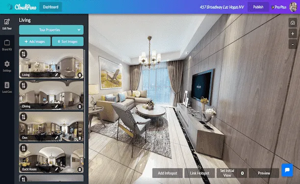
Create Interactive Engaging Content With CloudPano
360° virtual tours.
%20(1).webp)
To create your first 360º virtual tour click below:
360º Photography Services
%20(1).webp)
360º Virtual Tour Photography Services
Interactive 360° Spins
%20(1).webp)
To create a 360º spin click below:
How to Add a Virtual Tour to Google Maps
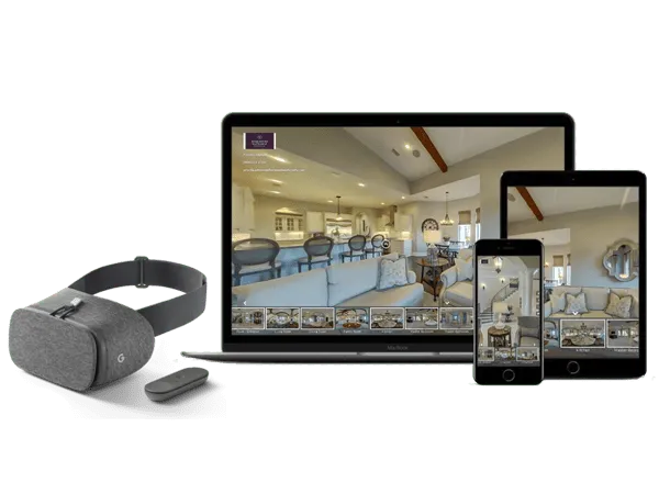
Create And Display Virtual Tours In 360 and VR
CloudPano 360° virtual tour software empowers you to create 360° virtual tours. Quickly create interactive virtual tours hassle-free. With a few clicks, you can upload, connect and publish a 360° immersive experience. No coding required. Get started today, its free. Click here.
How CloudPano Works
Create a 360° virtual tour with our easy three-step process.
.webp)
Capture photos in 360
Upload to CloudPano.com and create your tour
Share your tour with the world

Getting Started
What is a 360 virtual tour.
A 360 virtual tour on CloudPano is a real estate marketing tool to view and share a space in an immersive 360 environment. With a smartphone, the CloudPano viewer responds to your movement. This creates a responsive and immersive view of the property. Create your first 360 virtual tour in 5 minutes or less.
Add or Embed 360 Virtual Tours on any Website
(no app or plugin required).
When you publish a 360 virtual tour on CloudPano.com, you will automatically receive a code based link. You can embed your tour right onto your website. We host the tour, you show it off to the world.
Check out a live example
Cloudpano 360 virtual tour examples.
Explore some of our featured 360 tours from the CloudPano community
%20(1).webp)
Florida Luxury 360 Virtual Tour Click to view this demo
.webp)
New York VR Nursing Home Click to view this demo
.webp)
Auto Dealership Click to view this demo
.webp)
Luxury Residential Click to view this demo
.webp)
AirBnB Rental Click to view this demo
.webp)
Commercial Construction Click to view this demo
Simple 3D Tour Creation
Create your first tour in under five minutes..
Upload photos using a drag-and-drop interface. Click a single button to set an initial view for each scene. Add hotspots to navigate your tour.
Popular Features
Customize your logo
Set initial view
Re-order scenes
%20(1)%20(1)%20(1).webp)
Share In Full 360 and VR
Share and display on any smart device out of the box - no app required.
Give meaningful experiences to your viewers. Built-in motion sensing capabilities and VR-goggle modes work right in the mobile browser. Reach your customer on any platform. Simply share your virtual tour with a single URL link.
Android/iOS
Google Cardboard
No app to download
VR/Motion Navigation
Customize Your Tour Branding
Add logos, hotspot navigation and more.
Use linked hotspots to teleport between scenes. Add your logo and establish your brand.
Customize Your Logo
Contact Information
Share on social media
Keep Your Custom URL
.webp)
White-label your virtual tour
Use your own website domain.
Remove all references of CloudPano.com. Use your own logo and keep your website domain. Easily use your own URL. Add 360 virtual tours into your business and keep our name hidden.
Customize Your URL
Remove CloudPano Branding
The Perfect Software Toolkit For Virtual Tour Entrepreneurs
Start a local 360 virtual tour business, add virtual reality marketing to current business.

A Simple Software Solution To Power Your Virtual Tour Revenue
Private Label / White Label - Keep Your Website Domain Name and Protect Your Brand
Add or Embed Your Published 360 Virtual Tours Directly To Your Website or Blog (Wordpress Compatible)
Present Your 360 Tours In A Virtual Reality Headset
International Hosting On Local Server Networks (Speed Guaranteed)
CloudPano.com is a Virtual Tour Software built for entrepreneurs, photographers and real estate brokers. You will be empowered to create world class 360/VR virtual tours quickly, market real estate at a high level AND keep your brand on the front of tour. If you are looking for a 360 virtual tour software built for the business owner - you are in the right place.
Simple Pricing
Build a 360 virtual tour for free. Make the tour your own for a few dollars. One time fee, hosted tour for life.
- Unlimited 360 Photos
- Share Anywhere
- Gyroscope-enabled Motion Control
- Add Branding and Logo
- Hotspots and Infospots
- Three Free Tour Limit
- Remove "Made by CloudPano" watermark
- Embed On Your Website
- Complete access to CloudPano's 360 tour creator
- Unlimited tours
- Life-time tours - no expiration
- White-label/Bring your own URL
- 8K/High-def premium photo uploads
- Google Analytics
- Embed HTML and Media
- CloudPano Live Video Chat
- MLS-Compliant Tour Cloning
- Ambient Sounds and Music
- Tour Privacy Settings
- Lead Capture Tool
PRO PLUS BUSINESS
- Enterprise Partnership Access
- Custom Integrations
- Unlock Team Work Flows
- Industry Specific Feature Customization
- Dedicated Account Managment
- CloudPano Live For Sales Teams
- Custom Training
- Hardware Onboarding
- Host Account Bundles
- Branded Experience Management
CloudPano Pro User Testimonials
The technology is pretty amazing and the finished 3d tour is high definition. the tours played well on everything from a desktop to a cellphone. highly recommended., i just pitched a $2.5 million dollar fsbo with the vr headset and cloudpano software. i impressed the client, built rapport and added value with the vr presentation. it's marketing like that this that makes you stick out amongst your competition... and ultimately this moves property at a high level., this technology changes the game. my customers are very excited about it. and i know when my customers are excited about it, i am going to make some more money., 360 tours are an easy way to upsell my clients on location. plus, it only takes a few minutes to create a virtual tour on cloudpano.com., cloudpano has a crisp and clean design. plus the platform hosts the 360 virtual tours for me, so i can create tours quickly and get back to shooting., being able to have a full 360 tour of my listings and show sellers how i can take marketing of their home to the next level is huge i appreciate you and your team helping me out along the way answering any and all questions that i have had so far and i am excited to continue to implement and grow my business with the help of you and your team., common questions.
We are passionate about changing the world through software. Call us or email us anytime.
1301 Fannin St #2440 Houston, TX 77002
+1 (281) 410-8727
Email us at

© CloudPano.com

- PRO Courses Guides New Tech Help Pro Expert Videos About wikiHow Pro Upgrade Sign In
- EDIT Edit this Article
- EXPLORE Tech Help Pro About Us Random Article Quizzes Request a New Article Community Dashboard This Or That Game Popular Categories Arts and Entertainment Artwork Books Movies Computers and Electronics Computers Phone Skills Technology Hacks Health Men's Health Mental Health Women's Health Relationships Dating Love Relationship Issues Hobbies and Crafts Crafts Drawing Games Education & Communication Communication Skills Personal Development Studying Personal Care and Style Fashion Hair Care Personal Hygiene Youth Personal Care School Stuff Dating All Categories Arts and Entertainment Finance and Business Home and Garden Relationship Quizzes Cars & Other Vehicles Food and Entertaining Personal Care and Style Sports and Fitness Computers and Electronics Health Pets and Animals Travel Education & Communication Hobbies and Crafts Philosophy and Religion Work World Family Life Holidays and Traditions Relationships Youth
- Browse Articles
- Learn Something New
- Quizzes Hot
- This Or That Game
- Train Your Brain
- Explore More
- Support wikiHow
- About wikiHow
- Log in / Sign up
- United States Travel
- California Travel
How to Get to the Googleplex and Tour the Campus
Last Updated: August 23, 2023 Fact Checked
Getting to the Googleplex
Exploring google campus, touring with a google employee.
This article was reviewed by Seth Hall and by wikiHow staff writer, Ali Garbacz, B.A. . Seth T. Hall (ICF ACC, CLC, and MNLP) is a Certified Life Coach and Founder of Transformational Solutions, a Los Angeles-based life-coaching company that helps people achieve their toughest goals, find their own voice, and think outside the box. He has been a life coach for over 10 years, specializing in personal development, relationships, career and finance, and wellness. He has helped his clients break the negative cycles in their lives and replace them with a positive, proactive mindset. Seth believes that everyone has the potential to live a fulfilling and rewarding life, and works passionately to help them reach their full potential. With a deep understanding of how our minds work and the power of positive thinking, he encourages his clients to find their unique paths in life and find success on their own terms. He is a certified master practitioner of Neuro-Linguistic Programming, a featured co-author for WikiHow, and co-author of "The Mountain Method”, “The Happy Tiger”, and “The V.I.S.I.O.N.S. Program”. There are 12 references cited in this article, which can be found at the bottom of the page. This article has been fact-checked, ensuring the accuracy of any cited facts and confirming the authority of its sources. This article has been viewed 228,527 times.
Have you ever wanted to explore the place where all of the magic of Google happens? Well, if you happen to be in Silicon Valley, specifically Mountain View, you’ll be able to stop by the infamous Googleplex. While there are no official tours, visitors are more than welcome to walk around the outside of the Google campus. We’re here to give you all the insider information and tips about how to visit the headquarters of one of the world’s biggest tech companies. We’ve also got a lot of suggestions for fun things to do while you’re there, so keep reading!
Things You Should Know
- Get to the Googleplex (1600 Amphitheatre Parkway, Mountain View, CA) via car, bus, or train. Parking is free on the Google campus.
- Explore the outside of the Google campus on foot and look out for famous landmarks, like the giant T-rex statue named Stan.
- Ask a friend or acquaintance who works at Google to give you a tour of the inside of the office buildings.

- The Google campus is open for tourists to walk around 7 days a week. However, most office buildings are closed on weekends.
- To keep with the theme of your trip, use Google maps to plot out your journey efficiently.
- Google has 35 office and retail locations spread throughout the United States. Other U.S. cities that house Google offices include Los Angeles, Miami, Chicago, New York, and Portland.

- Caltrain is a commuter rail service that operates within the San Francisco Bay Area region.
- If you take the Mountain View city buses, the nearest stop to the Googleplex is Charleston & Google. From there, it’s about a 0.2 mile (0.3 km) walk to Google HQ.
- If you’re taking the Caltrain, get off at the Mountain View Caltrain Station and transfer to Mountain View city bus #40. Take this bus to the Charleston & Google stop, then walk the 0.2 miles (0.3 km) to the Googleplex.
- A day pass for the Santa Clara Valley Transportation Authority costs $7.50 while a one-way ticket costs $2.50 (for adults). [3] X Research source
- A day pass for the Caltrain costs $7.50 while a one-way ticket costs $3.75. [4] X Research source

- The parking lots are labeled A, B, C, D, and E.

- If you’re taking the bus and get off at Charleston & Google, you’ll be dropped off on the south end of the Google campus. Simply cross the street behind the bus stop to get to the Googleplex.

- There is no longer a Google Visitor Center for tourists to visit.
- Wear comfortable shoes to help you trek across the campus without hurting your feet.

- Make this the first stop on your Googleplex tour since it’s easy to access from the campus parking lots.
- In addition to the Google head office, Google Buildings 41, 42, and 43 are also in this cluster.
- There is also a volleyball court and a small green area near these buildings.

- If you’re lucky, you might see Stan wearing fun accessories, like pink flamingos.
- The giant T-Rex is also a nod to Silicon Graphics, a Hollywood effects company that worked on the huge dinosaurs that appear in the Jurassic Park movies. [10] X Research source

- You might also be able to see the Google Street View car. This is the car that drives around and takes pictures for the street view option on Google Maps. [12] X Research source

- If you do manage to score a tour, remain respectful and discreet as you tour the buildings. This is a workplace after all, and you wouldn’t want to disturb the hard-working people who are busy revolutionizing the tech industry.

- Green represents maximum healthiness.
- Yellow indicates food that features both healthy and unhealthy ingredients.
- Red signifies that the food is more decadent and not ideal for a healthy diet.

- These "nap pods" were created by a company called MetroNaps. [17] X Research source

- The Google Garden also has vast green spaces and meditation spots for Googlers to use freely.
Community Q&A
You Might Also Like

- ↑ https://about.google/locations/?region=north-america
- ↑ https://chasethehorizon.co/blog/96/visiting-google-and-twitter-headquarters-in-san-francisco
- ↑ https://www.vta.org/go/fares
- ↑ https://www.caltrain.com/fares/farechart
- ↑ https://www.sanjose.org/listings/googleplex-android-statue-garden
- ↑ https://www.siliconvalleyguide.org/
- ↑ https://youtu.be/72zcF1sQWEY?t=65
- ↑ http://business.financialpost.com/business-insider/an-inside-look-at-googles-luxurious-googleplex-campus-in-california
- ↑ https://www.theatlantic.com/health/archive/2011/07/what-googles-famous-cafeterias-can-teach-us-about-health/241876/
- ↑ https://youtu.be/Z-pT0XDYvDM?t=144
- ↑ https://metronaps.com/
- ↑ https://youtu.be/Z-pT0XDYvDM?t=213
About This Article

To visit Google headquarters, plan a trip to Mountain View, California, which is where the Googleplex is located. From there, you can explore the campus on foot and see some of the sights like the life-sized replica of a T-Rex skeleton. Check out the Visitor Center and the gift store for souvenirs, or grab a bite to eat at the Googleplex cafeteria. If you know someone who works at Google, ask them to give you a tour for greater access. For more information on how to visit Google headquarters and what you can do there, keep reading! Did this summary help you? Yes No
- Send fan mail to authors
Reader Success Stories
Joyce Elden
Apr 22, 2022
Did this article help you?
Featured Articles

Trending Articles

Watch Articles

- Terms of Use
- Privacy Policy
- Do Not Sell or Share My Info
- Not Selling Info
Don’t miss out! Sign up for
wikiHow’s newsletter

The Google Maps Features All Travelers Should Know About
I 'm a nerd for maps. As a kid, they inspired me to want to travel, and as an adult they're my comfort reading. My colleagues at AFAR even let me make a podcast episode about them . But of all the maps I love (Middle-earth included), the one I spend the most time with these days is Google Maps. I'm betting most of you can say the same thing. I'm on that app every single day. I use it for work (for the research I need to do in my job here as an editor and writer), I use it for fun (I can spend hours armchair exploring remote islands in the middle of oceans), and I use it, most invaluably, for trip planning. If you're only using Google Maps for directions, you're missing out. Here are a dozen ways I use Google Maps for smarter travel.
Collaborate an itinerary with friends
I make Google Maps lists of everything: I have one for vegetarian restaurants, another for ice cream shops-I even have one that's a cocktails and cookies trail. (I created that last one with my cousin when we celebrated her 21st birthday.) More often, I use lists as a trip-planning tool. As I'm researching things to do in whatever destination I'm headed to (recently Argentina, Nairobi, and Manchester ), I create a list, add places of interest (museums, restaurants, shops, libraries, etc.) and share it with my travel crew so that they can weigh in on my picks and add their recommendations. While that's useful, it's only 101.
In the past year, lists have leveled up: Now, for each place listing, your friends can react with an emoji (heart, smile, fire, thumbs down, or flying money) and add their tips and suggestions into a comments field (e.g., "I read that dulce de leche is the flavor to get!" or "Let's go here after our street-art tour on Monday."). I especially like that I can customize the order of the items on the list; for example, I could make them match the path of cookies I plan to follow, or I could arrange our collective Argentina picks chronologically so that the list doubles as our itinerary. A fun bonus is that you can assign any emoji to the whole list so that all of the places show up in map view with that themed icon-say, the Argentina flag or an ice cream cone.
Walk like you know where you're going with navigation
Turn-by-turn navigation isn't just for drivers. Google Maps offers it for walkers and bikers too. Once you type in your destination, select "directions," then "walking," then "start navigation," and the app will speak out loud to guide you, the same as if you were in a car. When I'm in a new city, I use this with one earbud in so I don't have to keep looking at my phone (because I will inevitably trip and fall over).
If you prefer to look at your phone, you can follow your route in both 2D (that little blue arrow moving on the map) or in 3D Live View. In this mode, you point your camera at the real world to get the app situated and then follow arrows and directions overlaid on the IRL view of the streets that you see through your phone. (Another settings option allows you to tilt your phone to enter Live View rather than tap.) Even more helpful, the recently released Glanceable Directions feature shows a minimap and navigation on your lock screen, so you don't have to open the app and turn on comprehensive navigation mode to get the benefits (toggle this feature on in settings). Conveniently, it'll automatically reroute if you take a different path.
Use augmented-reality Lens to find what's nearby: shops, restaurants, ATMs, and more
In addition to navigating with augmented-reality Live View, you can also use an augmented-reality (AR) function called Lens in Maps to see what's around you, including restaurants, public transportation stops, and landmarks. When in Maps, tap the little camera icon in the search bar, then point your phone at the street, and you'll start to see icons on the buildings. Note that this feature works only for select locations, but new cities are consistently rolling out. In the meantime, all of this information is still easily available in the app: Right under the search bar, you'll see popular search categories, including gas, restaurants, hotels, and groceries-and be sure to scroll all the way over to the "More" button. Tap that to see a couple dozen additional, and very specific, categories, including ATMs, libraries, live music, hospitals, pharmacies, and even EV charging stations.
Plan your EV charging route
Speaking of EV charging stations, Maps has expanded the info it provides on electricity pumps. To find them while you're on an EV road trip , type or speak "charging stations" into the search field or tap the "More" category button directly under the search bar. You'll immediately see red pins with a little lightning bolt inside them populate the map. In the information card below, the app will tell you which kind of chargers a station has (fast, medium, slow), how many are available, and whether they're compatible with your car.
Check what's open right now
When I was in Manchester last year, my friends and I went to a concert that let out late, and instead of heading directly to bed, we wanted to go out for a drink and a bite to eat. That's when I pulled out Maps to check what places were still open around us. In the app, look for "open now"-it's one of the options right under the search bar.
Use photos to get a sense of a place before you go
Nearly every listing in Google Maps has photos now, culled from public reviews and the establishments' owners. Admittedly, this isn't so much of a secret-but it is a secret weapon. You can use those photos to evaluate hotels, to check if a coffee shop is comfortable for laptop working, to see if a restaurant is likely to fit your big group or your mood, and to view images of menus. A recent AI-powered update uses those photos to give more travel inspiration. Try typing something like "cherry blossoms," "public art," or "swimming holes" into the search bar, and the results will include a carousel of photos and videos culled from public uploads, under the headline "Discover through photos."
See the future, and plan for it
Google Maps' Immersive View is photos on steroids. Well, on AI. For more than 500 landmarks around the world (including the London Eye, the Empire State Building, and Tokyo Tower), the search results include what looks like a video labeled "Immersive view." What you're seeing is actually a ton of photos that the app stitched together to create not just an image but a whole knowledge roundup of a particular destination. Want to see what traffic will be like on the Brooklyn Bridge tomorrow morning? Want to see the view from the Eiffel Tower as the sun sets tonight? You can do it now, through Immersive View. A small icon in the bottom right corner shows the weather and a clock-tap it to change the time of day, up to four or five days into the future, and the view will change too: the number of cars on the bridge, the clouds over Paris.
Share your real-time location to stay safe
When I am traveling solo , I always keep my location services turned on for safety (and also to ensure that my 7,000 photos of street art, grocery-store finds, and random architectural details are geotagged for later reference). But even if I'm traveling with friends or family, I use real-time location sharing when I head off on my own so that people know where I am. This is especially helpful if I'm running late, because they can see my arrival time and use that to make important decisions, like whether to order appetizers without me. On the map, you can tap your blue dot to see sharing options or go to your account icon in Maps and open location sharing to choose who and what you want to share. Bonus hint: Tapping the blue dot is also how you get to the option to save your parking location.
Download an offline map
If you're concerned about eating up mobile data-or if you're going to be in a location where you won't have good internet service, Google Maps has you covered. Tap your circular account icon at the top right of the app and go to Offline Maps to select the region you want to download; it will work the same as the live version. Whenever I travel, I download a big swath of the area I'm going to, even if I think I'll have plenty of internet access. You never know when you'll be in a dead spot.
Use overlays to get more information out of your map
Maps are like ogres and onions-they have layers. To find those layers, go into the app on your phone or desktop and click the icon that looks like a stack of tiny squares. You may already know that Maps can show you a satellite view layer, a terrain view layer, and the default cartoonish view layer. (The local weather forecast is always available too-look for the small icon on the left side of the screen just under the search bar.) But did you know that it can also overlay public transit routes, traffic statuses, bike paths, wildfires, and air quality? The public transit overlay is one of my favorites, whether I'm traveling or at home in NYC-the subway lines are even correctly color-coded.
Discover the Easter eggs
You've seen Google Maps' little orange Pegman, right? He's the icon that lives at the bottom right of the screen in the desktop app. Drag him into the map and you'll see a street view of almost any location. But in some spots around the world, he hides an Easter egg. Navigate to Loch Ness in Scotland, and when you pick him up, he's wearing a Nessie costume. At Area 51, he turns into a UFO. And in the Galapagos Islands, he has a mermaid tail. Can you find any others?
Stay tuned for more AI-powered features in the future
Google is working on bringing generative AI into its maps , and one project that's underway is a feature that will allow users to ask questions like "What are rainy-day activities I can do with kids?" When the feature is available (expected later this year), the map will show indoor suggestions such as bowling alleys and movie theaters. Google's community of more than 300 million "local guides," as they call their contributors, are working to test this now, and I'm already lining up my questions: Hey Google, what are some places that cartography nerds would like?
9 essential Google Maps tips for your Summer road trip
Hit the road with Google Maps this summer
- Departure times
- Share location
- Offline maps
- Reservations
- Avoid tolls
- Fuel-efficient routes
- Save parking
If you’re heading out on a road trip this summer, odds are you’ll be using an app like Google Maps to find your way around. It doesn’t matter where you’re going, or how long you plan to be on the road, it always helps to know where you are and how to get to wherever it is you need to be.
But there’s more to Google Maps than getting yourself from A to B. There’s loads more that this app can do, and if you’re going to be on the open road for an extended period of time you’d be wise to take advantage of them. But, of course, that requires knowing what Google Maps actually has to offer. Fortunately we can point you in the right direction.
Here are 9 Google Maps tips to help prepare you for your summer road trip.
1. Hands-free control
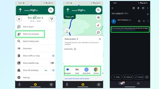
Google Maps has pretty strong ties to Google Assistant , so if you need to control the app while driving you can do most things using your voice. Android users can use the “Hey Google” command if it’s set up, or if you’re using Android Auto.
iPhone users can do this too, but you’ll need to go into Google Maps Settings then Navigation and toggle on Access your Assistant with OK Google. It’s a lot easier than trying to get stuff done in Google Maps with Siri and it only applies to Google Maps while navigation is active. Alternatively both platforms can trigger the voice command interface by tapping the microphone button on screen.
2. Plan your departure time
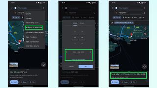
Traffic levels are always dependent on when you’re actually on the road, and predicting that by yourself is pretty much impossible. Fortunately Google Maps has libraries of historic traffic data at its disposal, and can estimate what traffic levels on your route will be like at specific parts of the day.
Just punch in your destination and hit Directions. The route preview screen will pop up, at which point you need to hit the three dot menu and tap the set depart or arrive time option. Set the time and day you plan on traveling, and Google Maps will give you a rough idea of how long the trip will take and what the traffic levels will be like along your route. So if they’re bad, you can alter your schedule to something a little more reasonable.
Sign up to get the BEST of Tom’s Guide direct to your inbox.
Upgrade your life with a daily dose of the biggest tech news, lifestyle hacks and our curated analysis. Be the first to know about cutting-edge gadgets and the hottest deals.
3. Add extra stops
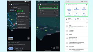
Need to go to multiple locations on your drive? You can add them all to a trip on Google Maps, either before or after you set off driving. Before is nice and easy: type in your final destination and press Directions. Once the route preview screen is open, press the three-dot menu followed by Add Stop. You can then search for places to add to the trip, be it a restaurant, gas station or something else. Just make sure to rearrange the order by pressing and holding the two parallel lines icon at the end of each stop.
The easiest way to add stops mid-drive is with voice commands. Ask Google Maps to add a gas station and it’ll show you a bunch of options. Tap the one you want on screen and Google Maps will add it to your trip after a few seconds. Alternatively press the magnifying glass at the top of the screen and you’ll be able to type in what you want — or choose from a number of popular pre-set options.
4. Share location and trip progress
If there’s someone waiting at the end of your drive, or you want someone back home to know you’ve arrived safely, then you can share your trip progress with Google Maps. Once navigation is active, swipe up the bottom menu and select Share trip progress.
Pick a contact to send it to — be it an email, text message or any number of other options — and the recipient will be sent a message with a Google Maps link. Opening this link shows them where you are in real time, what your estimated time of arrival is, and what route you’ll be taking. There’s also a battery life toggle, and sharing will automatically stop once you reach your destination — though you can switch it off anytime from the drag-up menu.
5. Offline mapping
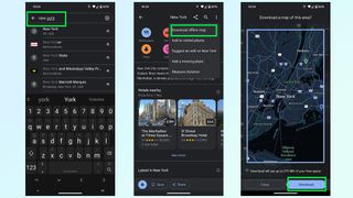
You can’t always guarantee that there’s going to be any cell signal where you’re going, and you don’t want to be cut off from your navigation system just because Google Maps lost its data connection. Fortunately Google Maps will let you download routes and maps for offline usage.
The good news is that Google Maps will automatically download a route as soon as you pump in your final destination — so you won’t lose directions mid-way through a drive. However this doesn’t account for times you need to make a diversion, or need to move onto a different spot after you arrive in a dead spot. So, you can download mapping data for a much larger region.
Simply search for an area or city, any area or city you like, and pull up the bottom menu. From there tap the three button menu in the top-right and choose Download offline map. This brings you to a map with a large blue square around it, which marks the area you’ll be downloading mapping data from. Zoom in and out, or move this box around to cover a different area and hit Download once you’re done.
6. Reserve a table or a hotel
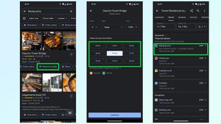
Not only does Google Maps include the ability to find restaurants and hotels, it also lets you check availability on any given day and book yourself a table or room from within the app itself.
Typically, trying to book something takes you to a third party website, be it a businesses official site or a third party booking service like Experia or OpenTable. However some of these businesses let you make reservations without having to leave Google Maps — saving you a little bit more time in the process.
7. Avoid tolls, ferries and highways
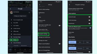
Unless explicitly told otherwise, Google Maps will direct you down what it considers to be the best possible route — which is usually either the fastest or shortest option available. But that may send you to some places you don’t want to be. Whether you’re skipping the cost of toll roads or ferries, or would rather a more scenic route than highways can offer.
Thankfully it’s very easy to tell Google Maps to avoid one or all of these things. Simply open up the Settings menu and scroll down until you find Navigation settings. The menu will give you a bunch of options, and you want to scroll down until it says Route Options.
Here you can tell Google Maps to avoid toll roads, highways and ferries. Toggle them on, and then head back to the main screen to get your directions.
8. Fuel-efficient routing
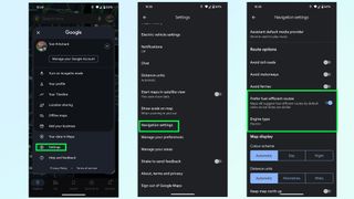
Gas is expensive, and EV charging takes a long time — even at a rapid charger. The last thing you want is to take some convoluted route that burns through more fuel than absolutely necessary.
Fortunately Google Maps is able to figure out the most energy efficient route for your car, based on the kind of fuel you use. Head to the Google Maps Settings menu then scroll down to Navigation settings. Scroll down this menu until you find Route Options and underneath the toggles to avoid tolls and highways is an option called Prefer fuel-efficient routes.
This should be enabled by default, but it pays to make sure it is switched on. Right below is an option called Engine type which will let you choose between Gasoline, diesel, electric and hybrid — because different engines’ efficiency varies depending on the kind of road you’re on.
9. Save your parking spot
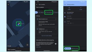
Nothing is worse than being lost in a parking lot, unable to find your car. So make sure to take advantage of this Google Maps feature that will save the location of your parking space and stop that disaster from happening. Once you park up simply hit the Blue dot that represents you on the map itself and tap the Save parking button on the menu.
Google Maps then drops a yellow pin with a large P in the center, marking your parking spot. This spot will also be saved in your recent history, and appears at the top of the menu when you tap the search bar. Simply tap that and Google Maps will fly to it, and give you the option to get directions to that spot.
More from Tom's Guide
- Google Maps is getting a big upgrade in time for your summer vacation
- Google Maps vs. Apple Maps: Which navigation app is best?
- 9 hidden Google Maps features everyone should know
Tom is the Tom's Guide's UK Phones Editor, tackling the latest smartphone news and vocally expressing his opinions about upcoming features or changes. It's long way from his days as editor of Gizmodo UK, when pretty much everything was on the table. He’s usually found trying to squeeze another giant Lego set onto the shelf, draining very large cups of coffee, or complaining about how terrible his Smart TV is.
You can now edit messages in Snapchat — but there are restrictions
I tested out Yelp's AI assistant to find a house cleaner — here are the results
Dyson V15s Detect Submarine Wet Dry Vacuum Cleaner review
Most Popular
- 2 5 dark sci-fi movies on Prime Video with 95% or higher on Rotten Tomatoes
- 3 NYT Strands today — hints, spangram and answers for game #63 (Sunday, May 5 2024)
- 4 You don’t need sit-ups to build a stronger core — just use this 5 minute bodyweight workout instead
- 5 This new PS5 controller is so good I can never go back to the DualSense Edge
NYC 5 Boro Bike Tour: Information on road closures, route and more
- Updated: May. 05, 2024, 12:06 p.m. |
- Published: May. 04, 2024, 10:00 a.m.

Participants in the TD Five Boro Bike Tour 2024 will ride through all five boroughs of the city and cross five major bridges as part of their 40-mile journey, including the Verrazzano-Narrows Bridge, before completing their journey in Fort Wadsworth.(Staten Island Advance)
- Ann Marie Barron | [email protected]
STATEN ISLAND, N.Y. — The largest charity bike ride in the world, the TD NYC Five Boro Bike Tour, will take place in the five boroughs of New York City on Sunday, bringing with it more than 32,000 participants and thousands of spectators.
Participants will ride through all five boroughs of the city and cross five major bridges as part of their 40-mile journey, including the Verrazzano-Narrows Bridge , before completing their journey in Fort Wadsworth.
Since 1977, the event has brought together cyclists from all walks of life and skill levels for an opportunity to experience New York completely free of cars annually.
“For the 46th year in a row, the TD Five Boro Bike Tour will provide cyclists from around the world the opportunity to ride through New York City’s five boroughs completely car free,” said Ken Podziba, CEO and president of Bike New York, the race’s nonprofit organizer. “This tour is especially important to us at Bike New York because each year it helps provide the funding and visibility we need to bring the joy of biking to New Yorkers.”
The TD Five Boro Bike Tour is the primary fundraising event for Bike New York, a nonprofit committed to empowering New Yorkers to transform their lives and their communities through cycling. Proceeds from the event directly help fund free public bike education and access programs for more than 30,000 adults and kids throughout the five boroughs, according to Bike New York.
Here’s everything you need to know about the 2024 TD Five Boro Bike Tour.
WHEN WILL IT TAKE PLACE?
The event will take place on Sunday, May 5, from 7:30 a.m. to 6 p.m.
WHAT IS THE ROUTE?
The 40-mile tour spans the city’s five boroughs, beginning in Lower Manhattan and traveling north into the Bronx, before heading to Queens, Brooklyn and ultimately, crossing the Verrazzano-Narrows Bridge and concluding in St. George near the Staten Island Ferry.
Click here to view a map of the route.
STREET CLOSURES
To accommodate the final leg of the tour, the Department of Transportation has announced that the following Staten Island streets will be closed on Sunday, at the discretion of the NYPD:
— Bay Street between New York Avenue and Hylan Boulevard
— Hylan Boulevard between Bay Street and Edgewater Street
— Edgewater Street/ Front Street between Hylan Boulevard and Hannah Street
— Hannah Street between Front Street and Bay Street
— Bay Street between Hannah Street and Richmond Terrace
— Richmond Terrace between Bay Street and Nicholas Street Wall Street between Richmond Terrace and dead end
Due to the event, part of the Verrazzano Bridge will be closed for the majority of the day on Sunday.
The Staten Island-bound lower level of the bridge will be closed from 2 a.m. to 7 p.m. on Sunday. The Bay Street exit near the bridge will also be closed from 7 a.m. to 7 p.m.
The Staten Island-bound upper level of the Verrazzano will remain open during the event, and is accessible from 92nd Street and the Belt Parkway entrance ramps.
Drivers are advised that closure times are subject to change and delays are expected.
STATEN ISLAND FERRY INFORMATION
The Staten Island Ferry will provide 30-minute service from 6 a.m. to 11 a.m. on Sunday. After that, the boat will run on a 15-minute schedule from 11 a.m. to 6 p.m. The ferry will then return to its regularly scheduled 30-minute service from 6 p.m. onward.
Bike New York, organizers of the Five Boro Bike Tour, noted that lines to take the ferry back to Manhattan could be long starting from the early afternoon.
All cyclists must board the boat on the lower level at both the Whitehall Terminal in Manhattan and the St. George Terminal, located at 1 Bay St. on Staten Island.
Riders must dismount and walk their bicycle while in the waiting area and when boarding and departing the boat. Riding on and off the boat is prohibited.
All bicycles must be stored in the designated area on the lower level of each vessel.
WILL PARTICIPANTS BE CHARGED A BRIDGE TOLL?
According to a source at Bike New York with knowledge of the situation, there has been no communication issued regarding riders possibly having to pay the toll for use of the bridge -- but the MTA had asked the non-profit to pay for the lost toll revenue starting next year, so the 2024 Five Boro Bike Tour would be unaffected.
Streets throughout the city will be closed that day along the route, and parking will be difficult for participants and spectators, who are advised to park their car on Staten Island for easy access by the ferry to the Bowling Green start in Manhattan.
It’ll also be convenient for cyclists, who won’t have to travel far to their car at the end of the race.
Paid parking in lots at the Staten Island Ferry in St. George are limited, due to ongoing construction, but there are several municipal lots nearby.
Another option would be to park near a Staten Island Railway station a few stops from the Staten Island Ferry. This is a good way to find free parking. Simply hop on the Staten Island Railway, head to the ferry, and off you go to the race start. Bikes are permitted on the train.
Paid Parking
Hours: 24/7
Cost: $25/day
Note: The Empire Outlets garage will be accessible for parking only until 8:30 a.m. on Tour day.
Hours: 8 a.m. to 8 p.m.
Cost: $12/day (Subject to change)
Pay with cash or credit card (no debit card)
Cost: $15/day (Subject to change)
Pay with cash, credit, or debit card.
Cars that park without checking in with an attendant are subject to being booted. Riders must comply with all posted rules and regulations.
Parking is on a first-come, first-served basis. Participants parking at South Beach can cycle to the Staten Island Ferry in order to get to the start area in lower Manhattan.
MTA Staten Island Railway
Cyclists may find luck parking on local streets near any stop, or in a free Staten Island Railway Park-and-Ride at Dongan Hills, Great Kills, Annadale, Prince’s Bay or Huguenot stations. Municipal parking lots are also available at Great Kills and Stapleton stations.
From there, participants and fans can easily then hop on a train to the Staten Island Ferry.
Bicycles will be allowed on the trains, and you can board at any Staten Island Railway station.
MetroCard fares are collected as you enter and exit at the St. George and Tompkinsville stations. Visit www.mta.info or dial 511 for more information.
NYC Five Boro Bike Tour 2024
- NYC Five Boro Bike Tour 2024: Everything you need to know for Sunday’s event
- NYC 5 Boro Bike Tour 2024: Be aware of these Staten Island street closures on Sunday
- NYC 5 Boro Bike Tour 2024: Here’s what we know about whether cyclists will have to pay lost bridge tolls
- Weather forecast for NYC 5 Boro Bike Tour 2024 calls for rain, cool temperatures
If you purchase a product or register for an account through a link on our site, we may receive compensation. By using this site, you consent to our User Agreement and agree that your clicks, interactions, and personal information may be collected, recorded, and/or stored by us and social media and other third-party partners in accordance with our Privacy Policy.

The Snob's Guide to Travel Google Docs
Virtual treasure maps. Elite e-tineraries. Password-protected pushpins. How the modern nomad aristocracy wanders the globe.
A year ago, while sitting in a café in Milan, I asked a recent American transplant to the city for spots off the beaten path that I wouldn’t have patronized during my fashion week tours of duty. What she did next surprised me. Pulling out her iPhone, she chirped, “I’ll share my Google Map with you!”
Now, I had been a casual user of “My Maps,” the feature Google rolled out in 2007 for the sole purpose of making navigation easier, and I had even exchanged such atlases with friends, but this one was curated by someone with exceptionally good taste who was plugged into a matrix of travelers with supremely covetable tips. As it turned out, I got a digital pushpin chart not just to Milano but to every single place I could ever want or need to visit— in the entire world . Hotels on small islands I’d never heard of. Vintage shops on secret side streets. Restaurants better than the usual foodie favorites. The kind of if-you-know-you-know places shared only with confidants, lest they be spoiled.

With one act of generosity, I was suddenly inside a whisper network that made Tripadvisor look basic and my own itineraries seem like amateur hour. Its members are not exclusively famous or wealthy; they’re a roving aristocracy of travel foragers, such as the digital strategist JiaJia Fei, who has been hitting the international art fair circuit for the last decade and has the Google Maps and Docs to show for it. While working at the Guggenheim Museum, she even helped create a publicly accessible map of installations around the world by James Turrell, who envisioned a sort of passport system where you’d get a stamp at each of his sites.
“I still refer back to this list when I travel to see if I can check one more off my list,” Fei says.
Virtual treasure maps may be tech’s latest innovation for streamlining movement, but they’re not entirely new. Long before Google’s office suite (around 300 BC, actually), advice on visiting foreign cities was handed out by friends, agents, experts, and, every so often, an indiscreet concierge full of local insights. Before the internet, intrepid globetrotters consulted their paperback Lonely Planets and Zagats, the latter of which began as a survey among friends in New York for insidery knowledge.
Back when Beverly Nguyen worked for celebrity stylist Kate Young, design houses sent around high-level cheat sheets for fashion week visitors. “Valentino would send out a guide that said, ‘Here are the best things to do. Make reservations here. Go to this museum,’ ” says Nguyen, who is now a sought-after stylist herself and the owner of a homewares shop. Social media turned everyone into an expert, and soon savvy young travelers were curating their own versions on Google Maps.
On it, users can flag places they want to go, star them, mark them as their favorites, or add them to a separate list called Travel Plans. They can then color-code each spot according to which category it falls into, leave notes for themselves, combine recommendations with those from others, and email the whole thing to friends, who can then email it to their friends. (Not so fast, though: Privacy settings can be turned on to prevent easy dissemination.) For many, collecting travel recommendations has become something like a game—gotta catch ’em all!—and the especially type-A will even create extensive Google guides to their own cities to keep up with the latest openings.

But apps are for beginners. Among nomadic connoisseurs, the most prized guides do not bear the signatures of celebrities or even reflect the sensibilities of boldfaced bohemians. These hot docs are passed around like contraband, because they’ve been around for years, edited, revised, and updated like epic poems that are never finished. Fei’s public maps for Miami, London, and Mexico City have thousands of views. Nguyen, who is proud of her guides to Paris, Naples, and Hong Kong, says celebrity stylist Thomas Christos Kikis, who counts Gabrielle Union and Sofia Vergara as clients, has a New Orleans tip sheet that’s hard to beat. And food writer Katie Parla’s Rome guide directs diners to non-pasta spots, say, Filipino or Bangladeshi meals.
“I rarely recommend that people go to the obvious things,” says Nguyen, who uses Google Sheets. “I’ll never say, ‘Go to the Ritz.’ ” Instead she’ll give you names of all the best Vietnamese restaurants in Paris, the phone number of a Loewe shopkeeper in Madrid who will take you out clubbing, and the coordinates of a no-name dive bar in Puglia. Twenty-two years ago Nils Bernstein, a food, wine, and travel journalist, received a Microsoft Word document of Mexico City recommendations from a local friend of his, and he slowly added to it himself. The list is now a 30-page Leviathan in 10-point type and perhaps the OG source of all the Mexico City guides out there. Bernstein is devoted to Word, but at some point someone uploaded the guide to Google Docs to make it more easily shared, and it has since been copy-and-pasted, whittled down, added to , and emailed ad infinitum.
“One time I was there with a group of friends who were visiting,” Bernstein says, “and one of them said, ‘Well, you know, that’s all good and fine, but I have a really, really, really good, trustworthy list.’ It was a close friend, but somehow he got it in such a roundabout way that he didn’t know it was from me.” He doesn’t worry about it ever getting in the wrong hands, or that he may have created a monster. “Most of my anxiety around it revolves around people having really old versions of it,” he says, adding that he tries to add updates regularly, but it can be hard to keep up. “Like, ‘Wow, this guy’s really lame. He doesn’t have all these hot new places.’”
Others are more protective of their recommendations, something I learned the hard way. That expat with the invaluable Milan map? The share settings changed the minute I touched down in New York.

Leta Sobierajski, an artist who works with the likes of Gucci and Comme des Garçons and travels frequently, particularly to Japan, will share her carefully curated itineraries only with IRL close friends (as opposed to her 100,000 Instagram followers ). “I used to have a map. I think I shared it with, like, two friends, and five or six years later I’m still getting weird requests from random people to access it,” Sobierajski says. “They don’t even email me. It’s just, ‘So-and-so-at-gmail.com is asking for permission,’ and that really bothered me. That disassociation—people don’t even really care what the curator’s interest is.”
To preserve the integrity of the practice, Aminatou Sow , an interviewer and New York Times best-selling author who was born in Guinea and grew up in Nigeria and Belgium, believes that recommendations should be earned. “I give up my very good ones only to people who I know will appreciate them and who have also given me very good recommendations,” she says. “It’s like all things in life: You can’t be a guest all the time; you also have to be a host.”
Today she keeps her thoughtful curation close to her chest, leaving personal notes for herself and intimates. “I make Google Maps for friends the way you would a mixtape, and I get a lot of pleasure out of that,” she says. “But what’s really magical is being bestowed a Google Map, and not having to ask for it.” That’s when you know you’ve really made it.

@media(min-width: 40.625rem){.css-1jdielu:before{margin:0.625rem 0.625rem 0;width:3.5rem;-webkit-filter:invert(17%) sepia(72%) saturate(710%) hue-rotate(181deg) brightness(97%) contrast(97%);filter:invert(17%) sepia(72%) saturate(710%) hue-rotate(181deg) brightness(97%) contrast(97%);height:1.5rem;content:'';display:inline-block;-webkit-transform:scale(-1, 1);-moz-transform:scale(-1, 1);-ms-transform:scale(-1, 1);transform:scale(-1, 1);background-repeat:no-repeat;}.loaded .css-1jdielu:before{background-image:url(/_assets/design-tokens/townandcountrymag/static/images/diamond-header-design-element.80fb60e.svg);}}@media(min-width: 64rem){.css-1jdielu:before{margin:0 0.625rem 0.25rem;}} In the Magazine @media(min-width: 40.625rem){.css-128xfoy:before{margin:0.625rem 0.625rem 0;width:3.5rem;-webkit-filter:invert(17%) sepia(72%) saturate(710%) hue-rotate(181deg) brightness(97%) contrast(97%);filter:invert(17%) sepia(72%) saturate(710%) hue-rotate(181deg) brightness(97%) contrast(97%);height:1.5rem;content:'';display:inline-block;background-repeat:no-repeat;}.loaded .css-128xfoy:before{background-image:url(/_assets/design-tokens/townandcountrymag/static/images/diamond-header-design-element.80fb60e.svg);}}@media(min-width: 64rem){.css-128xfoy:before{margin:0 0.625rem 0.25rem;}}

Why Ladylike Jewelry is Making a Comeback

Giovanna Engelbert is Instagram's Jewelry Guru

Why 'A Man in Full' Matters

Maya Rudolph Is a National Treasure

Meet Broadway's Newest Stars

This Is What Happens When a Jewelry Icon Evolves

Roman and Williams Celebrates T&C's April Issue
Anatomy of a Classic: Il Bisonte's Consuelo Bag

The T&C Investment Portfolio: Home Edition

Why Billionaires Are Buying Up Sports Teams

Sanderson Launches New Home Collection
Election Updates: Praising police, Trump calls crackdown at Columbia a ‘beautiful thing to watch.’
- Share full article

Chris Cameron
Donald Trump again attacked Robert F. Kennedy Jr., the independent presidential candidate who polls suggest is taking some support from Trump voters , in a post on his social media site, pleading that Republicans “don’t waste your precious vote on this phony liberal activist” while also insisting that Kennedy’s candidacy hurts President Biden more than it hurts him.
In an interview with local television in Waukesha, Wis., Donald Trump again said he would not sign a national abortion ban if elected , after a wide-ranging interview with Time magazine in which he suggested he would consider other federal abortion limits. He has struggled to strike a balance between siding with the anti-abortion activists who helped elect him in 2016 and what he sees as a risk to his electability.

Anjali Huynh
Trump has finished speaking in Freeland, Mich., where he blasted his New York criminal trial, laying into the judge who fined him, falsely suggesting the case amounts to political persecution and claiming, without evidence, that the trial is helping his poll numbers. The comments, among the first he’s made on the trail since the trial started, show how he plans to use the trial to rally supporters whenever he can hit the road.
In Michigan, Donald J. Trump again insists abortion should be left “to the states,” rather than supporting a federal ban. He praised the justices who overturned Roe but alluded to the electoral risk to Republicans, saying, “A lot of bad things will happen beyond the abortion issue, if you don’t win elections.” Kamala Harris, in Florida today, tried to make Trump the face of the state’s six-week abortion ban.

Michael Gold
At his second rally of the day, Donald J. Trump has spoken far more extensively about his criminal trial in New York, though he is mostly expounding on his view that the trial is, as he put it, “an unlawful exercise in very stupid and very evil politics” that is keeping him from campaigning.
Former President Donald J. Trump has taken the stage in Freeland, Mich., a state he visited last month for an event focused on illegal immigration and border policy. He opened today by briefly praising Mike Rogers, the Republican he endorsed in Michigan’s Senate race, before pivoting to criticizing the economy under President Biden.
Migrant crossings on the U.S.-Mexico border have dropped significantly in the first three months of the year, according to official figures , from a peak of 301,981 in December to under 200,000 a month from January to March. That could ease political pressure on President Biden, but Republicans are likely to continue attacking him by pointing out that border crossings remain relatively high.
Donald J. Trump, at a rally in Waukesha, Wis., called for tougher action against campus protests and again suggested some of the protesters were paid actors. He called on college presidents to “remove the encampments immediately, vanquish the locals and take back our campuses for all of the normal students.”
At his rally in Wisconsin, former President Donald J. Trump is again trying to walk a fine line on abortion. He is celebrating that the issue was returned to states after Supreme Court justices he appointed overturned Roe, while also criticizing Democrats for being too liberal and anti-abortion activists who are pushing for broader bans.
Former President Donald J. Trump, who has campaigned on a tough law-and-order message while facing criminal charges and criticizing the legal system, commended the New York police for arresting dozens of pro-Palestinian demonstrators at Columbia University. “That’s one good thing that really happened,” he said, adding later, “It was a beautiful thing to watch.”

Nicholas Nehamas
On the day that a six-week abortion ban went into effect in Florida, Vice President Kamala Harris warned a crowd in Jacksonville that Donald J. Trump would bring “more bans, more suffering, less freedom,” if he won in November. Harris and Democrats have sought to tie abortion bans directly to Trump, seeing abortion as a winning political issue.
Donald J. Trump at a rally in Waukesha, Wis., again contended without evidence that the protests at college campuses over the war in Gaza were an effort by the left to distract attention from the surge of migrants at the border. “Some people are saying they do the colleges so they can get your eyes off the border,” he said, repeating an assertion that he made on social media last night.
Donald J. Trump just took the stage in Waukesha, Wis., for his first rally since his trial in New York began. He noted that Republicans would hold their national convention in Milwaukee in July, telling the crowd of hundreds of his supporters, “That means you’ve got to vote for us because we’re spending our money in your state.”

Alyce McFadden
Robert F. Kennedy Jr. proposed that his campaign and President Biden’s campaign jointly conduct a poll in October to see who would do better against former President Donald J. Trump in a hypothetical two-way race. He teased the idea that the underperformer should drop out. But Biden really has no incentive to do this, and by October, it'd be too late drop off the ballot anyway.

Rebecca Davis O’Brien
The Libertarian Party is one of the more established third parties — it is on 37 state ballots, with plans for more. Angela McArdle, the party’s chair, said: “For 50 years, we’ve been trying to get our candidates on the main stage with major party POTUS candidates and we’ve finally succeeded in bringing one to our stage. We will do everything in our power to use this incredible opportunity to advance the message of liberty.”

Shane Goldmacher
Former President Donald J. Trump called Libertarians “some of the most independent and thoughtful thinkers” ahead of his speech to the party later this month and urged them “to remember that our goal is to defeat” President Biden. He added, “If Libertarians join me and the Republican Party, where we have many Libertarian views, the election won’t even be close.”

Reid J. Epstein
The Biden video, recorded Tuesday when he was in Wilmington, Del., is part of the Biden campaign’s effort to extend the news cycle surrounding former President Donald J. Trump’s interview with Time. Polling has shown abortion rights is Biden’s best issue against Trump; talking points the campaign sent to surrogates Tuesday urged them to focus attention on Trump’s abortion comments.
President Biden called former President Donald J. Trump’s comments on abortion in the Time interview published yesterday “shocking” in a video released by the president’s campaign Wednesday . “This should be a decision between a woman and her doctor,” Biden said. “And the government should get out of people’s lives.”
The Libertarian Party's invitation to Trump, to speak at the party's national convention , is an intriguing one at a moment when third-party candidates and ballot lines are a major focus of the 2024 race. A Trump spokesman did not immediately respond to a request for comment.

Neil Vigdor
Newt Gingrich, the former Republican House speaker, compared the student protesters who occupied a building at Columbia University to Juan M. Merchan, the judge presiding over Donald J. Trump’s criminal trial in New York. It was not the first time that he tried to make such an equivalency in Trump’s defense. In 2018, he likened the F.B.I. probe into Russia’s election interference to the “Gestapo.”
Michael Gold and Anjali Huynh
Michael Gold reported from Waukesha, Wis., and Anjali Huynh from Freeland, Mich.
Trump praises police crackdowns on campus protests.
Holding his first campaign rallies since his criminal trial in Manhattan began, former President Donald J. Trump on Wednesday urged college presidents to take a tougher approach to protests over the war in Gaza that have swept across campuses and praised police action at the demonstrations.
Calling protesters “raging lunatics” and suggesting without any evidence that they were hired by liberal groups to draw attention away from the surge of migrants at the border, Mr. Trump commended New York City police officers who, in riot gear, arrested dozens of pro-Palestinian demonstrators at Columbia University and cleared a building that they had occupied.
Speaking to supporters in Waukesha, Wis., Mr. Trump called for similar actions at universities across the country.
“To every college president, I say remove the encampments immediately,” he said. “Vanquish the radicals and take back our campuses for all of the normal students.”
Both in Wisconsin and at a later rally in Freeland, Mich., Mr. Trump promoted a strong a law-and-order message, even as he contends with a criminal case in New York in which he is accused of falsifying business records to cover up a sex scandal.
Mr. Trump, who on Tuesday was held in contempt and fined $9,000 for violating a gag order in the trial that bars him from attacking witnesses and jurors, criticized the order. He laid into the judge who fined him, calling him “crooked” and “conflicted” at both rallies.
“I have a judge who gags me,” Mr. Trump said. “I’m not allowed to talk about things. And nobody’s seen anything quite like it.”
And he reiterated his typical complaints about the criminal case: that it is a sham, that it is impossible for him to get a fair trial in deep-blue Manhattan and that the whole ordeal amounts to political persecution by President Biden — a claim made without a shred of evidence but that has helped him bolster support among his base.
“What you’re witnessing in New York is not a legal proceeding — it’s an unlawful exercise in very stupid and very evil politics,” he said.
As Mr. Trump is tied down in court proceedings, he and Republicans have seized on the campus demonstrations as a wedge issue. They hope to foment discontent among Mr. Biden’s Democratic base over his handling of Israel, while also pointing to the protests to support Mr. Trump’s frequent contention that Mr. Biden is a weak leader.
In the past week, Mr. Trump has also used the protests to diminish violent episodes involving right-wing extremists that took place during his presidency. He tried to downplay the deadly white supremacist rally in Charlottesville, Va., in 2017, by calling it “peanuts” compared with the campus protests. One woman was killed and nearly 40 people were injured when a neo-Nazi plowed his car through a crowd of counterprotesters in Charlottesville.
And building on his bid to portray federal prosecutors as politically motivated, Mr. Trump suggested the government would be lenient with the protesters, comparing them to supporters who he has said were treated harshly after they stormed the Capitol on Jan. 6, 2021, in a bid to overturn his 2020 election loss.
Though he has made small campaign stops in New York City, Mr. Trump has in the weeks since his trial started been visible more as a criminal defendant than as a political candidate. A planned rally in North Carolina last month was canceled at the last minute because of weather.
“I’ve got to do two of these things a day,” Mr. Trump told the crowd in Michigan. “You know why? Because I’m in New York all the time with the Biden trial.”
Mr. Trump’s energetic demeanor at Wednesday’s rallies stood in stark contrast to the stern speeches he has given in the hallway outside the courtroom, and to reports from the court that depict him as dour, glowering or, at times, asleep. He bantered lightly with members of the crowd in both states and repeatedly expressed pride at the size of his crowds.
But Mr. Trump’s dark, and sometimes coarse, campaign message has changed little. He again argued that Mr. Biden’s leadership was steering the country toward doomsday and stoked fears about immigration, accusing Democrats of creating “mayhem” at the border. He also repeated unsubstantiated claims that Democrats were encouraging migration in order to register undocumented immigrants to vote.
On a day when abortion was in the spotlight again, with Florida’s six-week ban taking effect and Arizona lawmakers repealing their state’s 1864 ban , Mr. Trump largely kept his focus elsewhere. But he defended his position in an effort to neutralize an issue that Democrats hope to make central in 2024.
Mr. Trump has tried a balancing act on the issue, arguing that all abortion rights should be left to the states even as he has voiced opposition toward strict six-week bans. And he stressed the need to consider the political implications of calling for further abortion restrictions as Republicans try to win in November, saying in Michigan that “a lot of bad things will happen beyond the abortion issue, if you don’t win elections.”
In Wisconsin, he presented his views as a kind of compromise. “Some people will be very happy,” he said. “Some people won’t be as happy. But time will make this.”
Still, in Michigan, he praised the conservative justices who had overturned Roe v. Wade, singling them each out by name. His remarks there came shortly after Vice President Kamala Harris visited Florida , where she called the state’s new restrictions “another Trump abortion ban,” part of a larger effort by Democrats to tie Mr. Trump to strict limits on the procedure.
At both rallies, Mr. Trump also railed against Mr. Biden’s handling of the economy, arguing that the president’s economic policies were hurting the middle class and that Mr. Biden had not done enough to fight inflation.
Both parties are focused intently on winning Michigan and Wisconsin, two battleground states that were critical to Mr. Trump’s 2016 victory but flipped to Mr. Biden in 2020. Mr. Trump visited both states last month, shortly before his New York criminal trial began.
The Republican National Committee is holding its 2024 convention in Milwaukee, which Mr. Trump acknowledged in nearby Waukesha. “That means you’ve got to vote for us, because we’re spending our money in your state to have the big convention,” he said.
The two states were also central in Mr. Trump’s efforts to overturn his 2020 election loss. Last week, he was named as an unindicted co-conspirator in an investigation by the Michigan attorney general’s office into efforts he and his allies took to subvert Mr. Biden’s victory in the state. So far, 15 Republicans who acted as fake electors have been charged.
An earlier version of this article misquoted a statement from Donald J. Trump at a
campaign rally. He called on college leaders to “vanquish the radicals and take back our campuses for all of the normal students,” not “vanquish the locals.”
How we handle corrections
Michael Gold and Chris Cameron
Michael Gold reported from Waukesha, Wis. Chris Cameron reported from Washington.
Donald Trump, repeating his 2020 election lies, tells a Milwaukee newspaper that he will not commit to accepting the 2024 outcome.
Former President Donald J. Trump told The Milwaukee Journal Sentinel on Wednesday that he would not commit to accepting the results of the 2024 election, as he again repeated his lies that the 2020 election was stolen from him.
“If everything’s honest, I’ll gladly accept the results. I don’t change on that,” Mr. Trump said, according to The Journal Sentinel. “If it’s not, you have to fight for the right of the country.”
In an interview with Time magazine published on Tuesday, he also dismissed questions about political violence in November by suggesting that his victory was inevitable.
When pressed about what might happen should he lose, he said, “if we don’t win, you know, it depends. It always depends on the fairness of an election.”
Mr. Trump’s insistent and fraudulent claims that the 2020 election was unfair were at the heart of his efforts to overturn his loss to President Biden, and to the violent storming of the Capitol on Jan. 6, 2021, by a mob of supporters who believed his claims. Mr. Trump now faces dozens of felony charges in connection with those events.
Mr. Trump’s vow to “fight for the right of the country” also echoes his speech on the Ellipse on Jan. 6, where he told his supporters that “if you don’t fight like hell, you’re not going to have a country anymore,” before urging his supporters to march to the Capitol.
As he campaigns in battleground states this year, Mr. Trump has repeatedly tried to sow doubt about the integrity of the fall election, while repeating many of the same lies that he used to assail the integrity of the 2020 election. Months before any voting has taken place, Mr. Trump has regularly made the baseless claim that Democrats are likely to cheat to win.
“Democrats rigged the presidential election in 2020, but we’re not going to allow them to rig the presidential election — the most important day of our lives — in 2024,” Mr. Trump said at a rally in Freeland, Mich.
The Trump campaign did not immediately respond to requests for comment.
Mr. Trump has for years promoted the lie that he won Wisconsin in 2020, and he did so again in the Journal Sentinel interview. Even after Jan. 6, 2021, and years after his exit from office, he has repeatedly pressured Assembly Speaker Robin Vos , the top Republican in the State Legislature, to help overturn Mr. Trump’s loss in the state and to impeach the state’s nonpartisan chief of elections.
More than 1,250 people have been charged with crimes in connection to the Jan. 6 attack — and hundreds of people have been convicted . Mr. Trump said in a recent interview that he would “absolutely” consider pardoning every person convicted on charges related to the storming of the Capitol. A bipartisan Senate report found that at least seven people died in connection with that attack.
The former president and his allies have also installed election deniers in influential positions in his campaign and in Republican Party institutions. In March, Trump allies newly installed to the leadership of the Republican National Committee appointed Christina Bobb , a former host at the far-right One America News Network, as senior counsel for election integrity. A self-described conspiracy theorist, she has relentlessly promoted false claims that the 2020 election was stolen.
Ms. Bobb was indicted in Arizona last week, along with all of the fake electors who acted on Mr. Trump’s behalf in that state and others, on charges related to what the authorities say were attempts by the defendants to overturn the 2020 election results in Arizona.
The Trump campaign and the Republican National Committee have made an aggressive approach to “election integrity” — a broad term often used by Republicans to cast doubt on elections that the party lost — central to their efforts heading toward November.
Last month, the committee announced a plan to train and dispatch more than 100,000 volunteers and lawyers to monitor the electoral process in each battleground state and to mount aggressive challenges.
On Wednesday, Mr. Trump said at the rally in Freeland that his campaign and national and state Republican parties would put together “a team of the most highly qualified lawyers and other professionals in the country to ensure that what happened in 2020 will never happen again.”
“I will secure our elections because you know what happened in 2020,” Mr. Trump said at a rally in Waukesha, Wis., on Wednesday.
Mr. Trump lost Wisconsin by more than 20,000 votes .
Reporting from Jacksonville, Fla.
In Florida, Harris looks to make Trump the face of the state’s abortion ban.
Harris blasts trump over florida abortion ban, on the day that florida began to enforce its six-week abortion ban, vice president kamala harris delivered a searing attack on former president donald j. trump in jacksonville, fla., calling the measure “another trump abortion ban.”.
Today, this very day, at the stroke of midnight, another Trump abortion ban went into effect here in Florida. As of this morning, four million women in this state woke up with fewer reproductive freedoms than they had last night. This is the new reality under a Trump abortion ban. The contrast in this election could not be more clear. Basically under Donald Trump, it would be fair game for women to be monitored and punished by the government. Whereas Joe Biden and I have a different view. We believe the government should never come between a woman and her doctor. [crowd cheering]

On the day that Florida began to enforce its six-week abortion ban, Vice President Kamala Harris delivered a searing attack on former President Donald J. Trump in Jacksonville, calling the measure “another Trump abortion ban” and saying he was forcing women to live a “horrific reality” without access to essential medical care.
“As much harm as he has already caused, a second Trump term would be even worse,” Ms. Harris said to about 200 supporters at a convention center in a historically African American neighborhood.
If Mr. Trump were to win in November, she argued, Americans would be compelled to endure “more bans, more suffering, less freedom.”
President Biden has made abortion — a rare issue on which he polls strongly against Mr. Trump — a pillar of his re-election campaign. He and Ms. Harris have campaigned aggressively in states that have imposed abortion restrictions, including Florida, where the president spoke last week , and Arizona, where legislators voted on Wednesday to overturn a near-total ban dating to 1864.
The president and vice president have used their appearances to illustrate the consequences of electing Republicans, and have placed the blame for the bans squarely on Mr. Trump, whose appointments to the Supreme Court helped overturn Roe v. Wade. “Donald Trump did this” has become a frequent refrain in Mr. Biden’s ads and speeches — a pointed and direct attack from a campaign that has struggled to sell its message to voters.
Ms. Harris’s appearance in Jacksonville also allowed her to capitalize on an interview Mr. Trump gave to Time magazine that was published on Tuesday. In the interview, Mr. Trump refused to commit to vetoing a federal abortion ban — which seemed to contradict recent statements from him — and said he would permit states to punish women who violated abortion bans.
“Just this week, in an interview, Trump said that states have the right to monitor pregnant women to enforce these bans, and to punish pregnant women for seeking out abortion care,” Ms. Harris warned.
In talking points distributed to surrogates on Tuesday, the Biden campaign urged them to focus attention on Mr. Trump’s abortion comments. And on Wednesday it released a video of Mr. Biden speaking directly to the camera.
“There seems to be no limit to how invasive Trump would let the state be,” the president said. “This should be a decision between a woman and her doctor, and the government should get out of people’s lives.”
On Wednesday, the six-week ban had already started to change lives. About 15 minutes away from Ms. Harris’s campaign event in Jacksonville, a reproductive health clinic called A Woman’s Choice received calls from women seeking abortions.
One woman said she was calling from Georgia, which also has a six-week ban. An official at the clinic informed her that a six-week ban was now in effect in Florida, too.
“Oh, Lord Jesus,” the woman responded, before opting to make an appointment in North Carolina, the nearest state where an abortion for someone at her stage of pregnancy would be available.
Many women do not know that they are pregnant at six weeks. And Florida’s ban means patients in the Southeast will have to travel as far away as North Carolina and Virginia to seek abortions, an unaffordable expense for many.
“The extremists who wrote this ban either don’t know how a woman’s body works, or they simply don’t care,” Ms. Harris said.
Florida’s governor, Ron DeSantis, signed the six-week ban last year ahead of a failed bid for the Republican presidential nomination in which he tried to court social conservatives. Floridians will have the chance to overturn the law with a ballot referendum in November. That has revived faint hopes among Democrats that Florida could be in play in the presidential election, although the Biden campaign has yet to invest significant resources in the state and Republicans hold a major advantage in voter registration.
“This is going to be a game changer here in Florida. It’s going to be a motivator,” said Christina Diamond, the chief executive of Ruth’s List Florida, a group that works to elect Democratic women who support abortion rights.
“The reason we have a six-week ban,” Ms. Diamond added, “is because the State Legislature and our statewide offices are held by Republicans.”
To emphasize that point, the Democratic National Committee put up billboards around Florida with Mr. Trump’s face that told women how far they would have to drive to reach a state where they could receive an abortion. And it also hired a plane to fly over Mar-a-Lago, the former president’s home in Palm Beach, Fla., trailing a banner that read: “Trump’s Plan: Ban Abortion, Punish Women.”
(Mr. Trump is campaigning in Wisconsin and Michigan on Wednesday as the criminal trial against him in Manhattan is on break for the day.)
Republicans in Florida responded to Ms. Harris’s visit by talking about everything except abortion.
“In Florida, especially in Jacksonville, families are suffering under the train-wreck Biden-Harris Bidenomics,” Evan Power, the chairman of the Republican Party of Florida, said in a statement. “Groceries cost more. Gas prices are surging. And the cost of housing continues to push Americans’ wallets to the breaking point. Meanwhile, the open border lawlessness of the Biden Bloodbath has made all states — including Florida — a border state.”
Jacksonville has one of the largest Black populations in the United States, and the six-week ban will most likely have a disproportionate impact on African American women, who receive the procedure at higher rates than other groups.
The Biden campaign has been working to shore up its support among African Americans. Polling shows that Black voters are more likely to say abortion is their top issue. At the Jacksonville event, a marching band from Edward Waters University, a historically Black university, warmed up the crowd. Ms. Harris’s introductory speakers included Fentrice Driskell and Tracie Davis, two of the state’s most prominent Black politicians.
“We want the little girls of Florida to have the same freedom that their mothers and their grandmothers did,” said Ms. Driskell, a Tampa Democrat and the state House minority leader. “So let’s say it loud enough that they hear it from Jacksonville all the way to shake the walls of Mar-a-Lago: Get out of our health care. Get out of our exam rooms. We are taking our rights back.”
Abigail Geiger contributed from Jacksonville, Fla., Reid J. Epstein from Washington and Patricia Mazzei from Miami.
Chris Cameron and Michael Gold
Chris Cameron reported from Washington, and Michael Gold reported from Waukesha, Wis.
Trump says at rally that he wanted to go to the Capitol on Jan. 6.
Former President Donald J. Trump said on Wednesday that he asked his Secret Service detail to take him to the Capitol after his speech at the Ellipse on Jan. 6, 2021, acknowledging a key detail of his actions that were central to the findings of the House committee established to investigate the attack.
During a campaign rally in Waukesha, Wis., Mr. Trump brought up a sensational but disputed element of testimony given to the House Jan. 6 committee by a Trump White House aide: that Mr. Trump had lunged for the wheel and physically struggled with Secret Service agents when they refused to take him to join the large crowd of supporters who were marching toward the Capitol.
“I sat in the back,” Mr. Trump said, giving his version of events. “And you know what I did say? I said, ‘I’d like to go down there because I see a lot of people walking down.’ They said, ‘Sir, it’s better if you don’t.’ I said, ‘Well, I’d like to.’”
“It’s better if you don’t,” Mr. Trump recounted an agent saying. The former president said he replied, “All right, whatever you guys think is fine,” and added, “That was the whole tone of the conversation.”
President Biden’s campaign immediately highlighted Mr. Trump’s comments, amplifying that the former president had intended to participate in what would become an attack by his supporters on the Capitol in an effort to overturn Mr. Biden’s victory in the 2020 election.
It is not the first time that Mr. Trump has spoken of his effort to go to the Capitol on Jan. 6. He has said in several interviews that he regretted not marching on the Capitol with his supporters that day, and that his Secret Service detail prevented him from doing so.
“Secret Service said I couldn’t go,” Mr. Trump said in an interview with The Washington Post in April 2022 . “I would have gone there in a minute.”
Cassidy Hutchinson, the former White House aide, later testified to Mr. Trump’s conversation with Secret Service agents during televised hearings held by the House Jan. 6 committee. Ms. Hutchinson was not in the car with Mr. Trump, and said that her testimony to those events came secondhand or thirdhand from what other people had told her that day.
In an interview with the same committee, Mr. Trump’s driver, whose name was not disclosed, said: “The president was insistent on going to the Capitol. It was clear to me he wanted to go to the Capitol.”
Mr. Trump at the rally on Wednesday portrayed his requests to his Secret Service detail as casual ones.
In the interview with investigators for the House panel, the driver said that while he did not see Mr. Trump accost agents or reach for the steering wheel, “what stood out was the irritation in his voice, more than his physical presence.”
After Mr. Trump was driven back to the White House by his Secret Service detail, the former president sat and watched the ensuing violence play out on television, according to testimony by an array of former administration officials . After Mr. Trump’s speech at the Ellipse where he repeated his false claims that the election was stolen from him and urged attendees to march on the Capitol , a mob of his supporters overran police barricades to storm the building, temporarily disrupting the certification of Mr. Biden’s victory.
In a lengthy interview with Time magazine published on Tuesday, Mr. Trump said he would “absolutely” consider pardoning every person who had been convicted on, or pleaded guilty to, charges related to the storming of the Capitol on Jan. 6. He also would not rule out the possibility of political violence after this year’s election.
“I think we’re going to win,” he said. “And if we don’t win, you know, it depends. It always depends on the fairness of an election.”
Shane Goldmacher , Neil Vigdor , Nicholas Nehamas and Maggie Astor
more news from the campaign
Trump to address Libertarian Party, hundreds of Black women endorse Alsobrooks in Maryland and more.
The Libertarian Party announced that Donald J. Trump will address the party’s national convention in late May in Washington, D.C., calling it the first time a former president will speak to a gathering of the party. — Shane Goldmacher
Over 650 Black women — ranging from House members to local activists — endorsed Angela Alsobrooks against Representative David Trone in Maryland’s Democratic Senate primary and criticized a recent ad from Trone. The ad featured Black officials questioning the qualifications of Alsobrooks, the executive of Prince George’s County, and suggesting she might need “training wheels”; the statement said that the ad “echoes tones of misogyny and racism.” Race has been a major undertone in the contest; Alsobrooks is Black and Trone is white. Some of Trone’s supporters hit back: State Senator Jill P. Carter, who is also Black, said she thought the ad was not an attack but simply “a campaign ad where some individuals are speaking about their specific experience.” — Maggie Astor
Almost four in 10 local election officials who were surveyed by the Brennan Center of Justice for a new report said they had experienced threats, harassment or abuse, another sign of the duress that the group has been under since the 2020 election. Sixty-two percent said they were worried about political leaders trying to interfere with how they or other election officials did their jobs. — Neil Vigdor
Florida’s six-week abortion ban takes effect today, giving Democrats another opportunity to press their case against former President Donald J. Trump. In a statement, President Biden called the ban “extreme” and a “nightmare,” and said voters would teach Trump “a valuable lesson” in November. — Nicholas Nehamas

Katie Glueck
From Florida to Arizona, abortion politics are dominating the 2024 race.
In Florida, a ban on most abortions after six weeks of pregnancy took effect.
In Arizona, state lawmakers repealed a stringent abortion ban that dates to the Civil War era.
And across the country, the presidential campaign trail on Wednesday was brimming with reminders of just how central Democrats hope the abortion rights debate will be to voters’ decisions this fall.
Nearly two years after the Supreme Court overturned Roe v. Wade , Democrats are betting that the tangible effects of abortion restrictions that many Americans are already experiencing — and the threats of more to come — will help their party power through an ominous and volatile political environment, as Republicans struggle to address an issue that has become a significant, sustained liability for them.
“Donald Trump is to blame for the harm state abortion bans are doing to women every day in our country,” Vice President Kamala Harris wrote on social media on Wednesday morning, ahead of delivering remarks n Jacksonville, Fla., about the state’s “extreme” new ban.
Mr. Trump, she said there, would bring “more bans, more suffering, less freedom,” if he won re-election.
As they did in the midterm elections in 2022, Democrats are borrowing from language long favored by Republicans — about freedom and limiting the reach of government — to make their case.
They believe that Mr. Trump, whose Supreme Court nominees helped overturn Roe, recently bolstered their argument further.
In a Time magazine interview released on Tuesday, Mr. Trump refused to commit to vetoing a national abortion ban and said he would allow states to monitor women’s pregnancies and prosecute those who violated abortion restrictions.
“There seems to be no limit to how invasive Trump would let the state be,” President Biden said in a video released on Wednesday morning. “This should be a decision between a woman and her doctor, and the government should get out of people’s lives.”
The focus on abortion rights propelled Democrats in the midterm elections, when candidates harnessed voter anger over abortion restrictions to overcome challenging national headwinds in key contests.
And it has remained a potent force in subsequent elections.
State Representative Mike Caruso of Florida, a Republican who opposed the six-week ban, noted that a number of states including Florida are expected to have abortion rights-related measures on the ballot this fall.
“It’s going to hurt Republicans,” he said. For Democrats who were unenthusiastic about Mr. Biden, he said, “now they’ve got reason they can show up. I think it’s going to have a major impact on the elections in November.”
But it is not yet clear how galvanizing the issue will be across the country in a presidential election shaped by economic concerns at home and crises abroad, with two well-known and unpopular men — one of whom, Mr. Trump, faces multiple criminal cases — at the top of their party’s tickets.
“President Trump has long been consistent in supporting the rights of states to make decisions on abortion,” Karoline Leavitt, a spokeswoman for Mr. Trump, said in a statement. “Women want a president who will secure our nation’s borders, remove violent criminals from our neighborhoods and build an economy that helps hardworking families thrive.”
And even as Democrats sought to keep the issue at the forefront of voters’ minds on Wednesday, they were competing with unrest at college campuses across the country, including in critical battleground states, as students protested the war in Gaza, with many objecting to Mr. Biden’s support for Israel.
Such scenes of turmoil, some party strategists have warned, can be damaging for the party that controls the White House.
Nicholas Nehamas contributed reporting.
A new progressive PAC is targeting 8 key House races in California.
Democrats nearly pulled off the impossible in the 2022 midterms.
In the final weeks of the campaign, with an unpopular president in his first term, polls forecast a red wave that would sweep the country and flip control of the House and the Senate — prompting alarm from Democrats and predictions from Republicans of a decisive victory.
But that wave never materialized, a mirage of bad polling and inflated expectations . Democrats came close to maintaining a national trifecta, but Republicans eked out a thin majority in the House — prevailing in a handful of seats in New York and California, each by just a few thousand votes .
Now, a new coalition of progressive groups in California has formed a super PAC aiming to bolster Democratic candidates in a state that the party sees as crucial to winning control of the House this fall.
The super PAC, Battleground California, says it aims to spend $15 million this year on eight competitive House races, seven with Republican incumbents — in Northern California, Orange County, the Inland Empire east of Los Angeles, the Central Valley and Los Angeles — as well as the seat left open by Representative Katie Porter, a Democrat who is not running for re-election after a failed Senate campaign.
It is an ambitious effort, one that seeks to establish a durable progressive machine in California — advised and supported by local activists and community organizations — to lift swing district Democratic candidates through an extensive field operation, including marathon door-knocking campaigns aimed at driving turnout among minority groups.
“Trusted messengers from the community are a very critical element,” said Steve Phillips, a co-founder of the California Donor Table, the group leading the Battleground California PAC, adding that those residents are not only more trusted by voters but are better able to provide feedback on what messages work and what messages don’t.
Pablo Rodriguez, the executive director of Communities for a New California, a group focused on civil rights, is among the activists working with the PAC. He said that focusing on local issues, and less on the “national noise” generated by President Biden and former President Donald J. Trump, would be the key to victory.
“The path towards victory,” Mr. Rodriguez said, “is not making big TV or radio buys or even digital ad buys, right? We need to actually have face-to-face conversations with voters.”
Battleground California has set a challenging goal. Only two of the seven Republicans that the PAC will spend against — Representatives David Valadao and John Duarte, who represent predominantly Latino districts in the Central Valley region — won their 2022 races by what would be considered close margins. They will both face rematches with their 2022 opponents: Rudy Salas and Adam Gray, two Democratic former state assemblymen.
The PAC’s target spending figure of $15 million, while substantial, will not go far in a state where House races can get expensive. In the Central Valley, the race for Mr. Valadao’s seat in 2022 fielded more than $25 million in outside spending . Ms. Porter also spent more than $28 million on her re-election campaign . Michael Gomez Daly, political strategist at California Donor Table, said the coalition had raised about $1.3 million to date, aiming for $5 million by July.
Mr. Phillips and Mr. Daly said their targets were within reach for Democrats with enough investment of resources.
“All the districts should be flippable,” Mr. Daly said. He declined to say how many victories would be considered a success, adding that “failure is not really an option this cycle.”
Both Mr. Gray and Mr. Salas attributed their losses in 2022 to depressed turnout, and in interviews they both highlighted their efforts to start get-out-the-vote efforts early. They also had high expectations for a boost in presidential-year turnout.
Mr. Valadao and Mr. Duarte declined interview requests, but Republican pollsters, strategists and consultants in California have said that demographic changes and new efforts to reach voters of color have shifted the balance of power in their favor. They point to Mr. Valadao’s close victory in 2020, as well as wins by minority candidates like Representatives Young Kim and Michelle Steel in that same year. Others say that the presidential race is just as likely to inflate turnout among Republicans.
“It’ll be close, but Valadao will win,” said Cathy Abernathy, a Republican campaign consultant in Kern County. “And he’ll win most likely because Trump’s on the ballot.”
The Republican voter base is also growing in the Central Valley districts represented by Mr. Valadao and Mr. Duarte, according to registration records by the California secretary of state’s office, a net gain of several thousand voters in both districts from September 2022 to February this year — exceeding the narrow margin of victory in those seats in the 2022 races.
“It’s a little bit of contrast to, I think, the typical narrative that people of color are more progressive-minded,” said Rachel Hernandez, a member of the City Council in Riverbank who is running for mayor. Instead, she added, “what we’re seeing in the Central Valley is that the Latino community is electing more conservative candidates.”
Ms. Hernandez added that, for now, that is not an irreversible trend, but a warning sign for Democrats to pay attention to the nuances of the Latino electorate. She encouraged many of the same tactics that Battleground California says it plans to use: molding a message for the needs of a specific community, and working with staff members and volunteers who represent the community.
“My volunteers, for example, up until just this weekend actually, were all young women,” Ms. Hernandez said. “Young Latina women, college-aged, who approached me because they were saying ‘Wow, this is like our campaign.’”
Trump is heading to two Midwest battlegrounds, his first major campaign events since his criminal trial began.
Former President Donald J. Trump will return to the campaign trail today, with stops in Wisconsin and Michigan, his first major events in battleground states since the beginning of his felony criminal trial three weeks ago.
Vice President Kamala Harris will deliver remarks “about the fight for reproductive freedoms” in Jacksonville, Fla., as a six-week abortion ban begins in that state. Her visit is part of a national tour aimed at energizing Black voters in battleground states. In Washington, President Biden will attend a campaign reception at the Mayflower Hotel.
Mr. Trump will first deliver remarks in Waukesha, Wis., before holding a rally later in the evening in Freeland, Mich. Thousands of voters in the county, Saginaw, backed Nikki Haley in the Republican primary, though Mr. Trump has so far not directly appealed to her voters for support.
With friendly audiences, Mr. Trump is likely to use his bully pulpit during his Midwest trek to attack the justice system. He has repeatedly asserted without evidence that his legal troubles are a conspiracy to interfere in the election, and he has argued that he should be immune from criminal charges for actions he took as president — while simultaneously promising to wield the Justice Department to go after President Biden and his family .
But Mr. Trump became familiar with the limits of those attacks on Tuesday, when the judge in his criminal trial held him in contempt for violating a gag order for attacking witnesses and jurors. He was fined $9,000 and ordered to take down offending posts on his social media site, Truth Social. Mr. Trump complied and took the posts down before a midafternoon deadline.
The former president is also expected to speak about escalating clashes between the police and pro-Palestinian demonstrators on college campuses. Mr. Trump has painted the mostly peaceful protests as “riots,” filled with “tremendous hate.” He has also repeatedly distorted the violent white supremacist rally in Charlottesville, Va., in 2017 in comparing the two events, describing it on Tuesday morning as “a big hoax” when compared with the campus protests.

Reporting from Atlanta
Federal judges block Louisiana’s newly drawn congressional map.
A newly drawn congressional map in Louisiana was struck down on Tuesday by a panel of federal judges who found that the new boundaries, which form a second majority Black district in the state, amounted to an “impermissible racial gerrymander” that violated the Equal Protection Clause of the U.S. Constitution.
The 2-to-1 ruling now leaves uncertain which boundaries will be used in the November elections, which are just six months away and could play a critical role in determining the balance of power in the House of Representatives.
Critics warned that the decision could have broader implications on voting rights. Eric H. Holder Jr., the former U.S. attorney general and current chairman of the National Democratic Redistricting Committee, said the “ideological nature of the decision could not be more clear.”
Louisiana’s attorney general, Liz Murrill, a Republican, indicated on Tuesday that the case could advance to the U.S. Supreme Court. “I’ve said all along the Supreme Court needs to clear this up,” she wrote on social media .
The judges have scheduled a hearing on May 6 to discuss next steps. The Louisiana secretary of state has ordered that the congressional map be finalized by May 15.

Read the Federal Judges’ Ruling
A newly drawn congressional map in Louisiana was struck down by a panel of federal judges who found that the new boundaries, which form a second majority Black district in the state, amounted to an “impermissible racial gerrymander” that violated the U.S. Constitution.
The new districts had been outlined in January during a special session of the State Legislature. Lawmakers had been ordered to sketch out the new boundaries after a three-judge panel of the U.S. Court of Appeals for the Fifth Circuit found that the previous map had very likely violated the Voting Rights Act by diluting the voting power of Black residents.
But the new maps went before another panel of federal judges after a group of residents scattered across the new congressional district who describe themselves as “non-African American” voters challenged the maps. They argued that lawmakers had moved to “segregate voters based entirely on their races,” and to achieve that they stitched together “communities in far-flung regions of Louisiana.”
The new majority Black district cuts across a long, narrow swath that reaches from Baton Rouge, the capital city in the toe of Louisiana’s boot, to Shreveport, in the northwest corner of the state. About 54 percent of the district’s population is Black.
In the ruling on Tuesday, Judges David C. Joseph and Robert R. Summerhays, both of the Western District of Louisiana, acknowledged that factors other than race, like protecting certain incumbents, had figured into the process. Even so, they said, it was evident that creating a second district with a majority of Black voters was lawmakers’ overarching objective.
“The predominate role of race in the state’s decisions,” the judges wrote, “is reflected in the statements of legislative decision makers, the division of cities and parishes along racial lines, the unusual shape of the district and the evidence that the contours of the district were drawn to absorb sufficient numbers of Black-majority neighborhoods to achieve the goal of a functioning majority Black district.”
The judges noted that the ruling did not decide “whether it is feasible to create a second majority Black district in Louisiana that would comply” with the Equal Protection Clause. But they added that the Voting Rights Act “never requires race to predominate in drawing congressional districts at the sacrifice of traditional districting principles.”
In a dissenting opinion, Judge Carl E. Stewart of the Fifth Circuit argued that the challengers had failed to prove that their constitutional rights were violated.
“The totality of the record,” he wrote, “demonstrates that the Louisiana Legislature weighed various political concerns — including protecting of particular incumbents — alongside race, with no factor predominating over the other.”
The ruling is the latest wrinkle in the lengthy legal battle over the shape of Louisiana’s congressional districts and comes as other Southern states have also been forced by courts to redraw district lines amid accusations of racial discrimination.
Louisiana was obligated to redraw congressional districts after the 2020 census to take into account population changes. The census had found that the Black population in the state had increased by 3.8 percent over the past decade, meaning that roughly a third of the overall population was Black. But in the map drawn by the Republican-controlled Legislature, only one of the six congressional districts had a majority Black population.
In June 2022, a federal judge found that the map had been racially gerrymandered and illegally weakened the electoral power of Black voters. The judge ordered lawmakers to create another district that would give Black voters the chance to elect a candidate of their choice. But the disputed map was still used in the 2022 election.
Other Southern states had also been ordered to redraw maps after a surprise U.S. Supreme Court ruling last year in which the justices threw out Alabama’s congressional boundaries, finding that they did not adequately account for the state’s Black population. The ruling reaffirmed the Voting Rights Act of 1965, which had been diminished over the years by the court’s conservative majority.
Critics of Tuesday’s ruling argued that the repercussions in Louisiana could extend beyond a single election, or even partisan divisions. Ashley Shelton, who leads the Power Coalition for Equity and Justice, which was part of the challenge to the original 2020 map, said she and others remained undeterred.
“We will continue to fight for a map that reflects our communities, that honors the promise of the Voting Rights Act,” Ms. Shelton said, “and that respects the voices of thousands of Louisianians who have engaged throughout the redistricting process. We have been clear since day one in our call for a fair and representative map.”

Nicholas Fandos
Democrats win a special House election in New York, narrowing the Republican majority.
Timothy M. Kennedy, a Democratic New York State senator, easily won a special House election on Tuesday to replace a retiring congressman in western New York, according to The Associated Press .
The victory was hardly a surprise. Democrats have controlled the Buffalo-area district for decades. And Mr. Kennedy outspent his Republican opponent, Gary Dickson, by an eye-popping 47 to 1 .
But his victory will have an immediate impact on the House at a time when Speaker Mike Johnson of Louisiana is laboring to hold onto a narrow Republican majority and fend off a rebellion on his right flank.
Once Mr. Kennedy is seated, Mr. Johnson’s margin will effectively shrink to just a single, tenuous vote on partisan issues. A handful of special elections in Wisconsin, Ohio, Colorado and California are expected to offer Republicans reinforcements, but not until this summer.
In the meantime, Mr. Kennedy, 47, is expected to provide a reliably liberal vote. He campaigned on a familiar Democratic platform, promising to fight for federal infrastructure dollars for a region that has struggled economically, for federal abortion rights and against former President Donald J. Trump, the presumptive Republican nominee to face President Biden this fall.
Mr. Dickson, a former F.B.I. agent and local town supervisor, ran a relatively moderate campaign for a Republican in the Trump era. He had endorsed the former president, but called the Jan. 6 Capitol riot “a travesty.” He supported Ukraine’s war against Russia and federal investment in transportation projects, spending priorities that more conservative Republicans forcefully oppose.
But it was not enough to win over a district that counts more than twice as many Democrats as Republicans. With 62 percent of the votes counted, Mr. Kennedy was beating Mr. Dickson by 34 percentage points, 67 to 33.
The seat was vacated in February by the retirement of Brian Higgins , a moderate Democrat who had represented the Buffalo area for 19 years.
Mr. Higgins, who left the job early to lead Shea’s Performing Arts Center in Buffalo, was part of a wave of seasoned lawmakers from both parties heading toward the exits this year. Like many others, Mr. Higgins, 64, cited an increasingly toxic and unproductive environment on Capitol Hill.
Mr. Kennedy is a former occupational therapist who has served in the New York State Senate since 2011. In Albany, he led an important legislative committee on transportation and supported a tough package of gun safety measures after a racist shooter killed 10 people at a Buffalo supermarket in 2022. He also earned a reputation as a prolific fund-raiser.
He was selected directly by party leaders as the Democratic nominee to serve the remainder of Mr. Higgins’s term. Mr. Kennedy will likely remain in campaign mode this year, with a Democratic primary in June and November’s general election still ahead.
The district sweeps north from Buffalo, including the city, many of its suburbs and Niagara Falls.
Advertisement

COMMENTS
Find local businesses, view maps and get driving directions in Google Maps.
Explore Tours, France with Google My Maps, a tool that lets you create and share custom maps. See the landmarks, culture, and history of this city.
Here are the best Google Maps tours that are available on Google Earth. 1. Life in the Ocean Deep. With Life in the Ocean Deep, you can discover mysterious sea creatures with the help of renowned naturalist Sir David Attenborough. This Google tour takes you on a journey through the many quirky yet breathtaking creatures that inhabit our oceans ...
2. Create a new map through the home screen. At the top left of the "My Maps" home screen, you'll see a red box with the text "+Create a New Map.". Click on it to be redirected to a map screen. [3] 3. Give your map a descriptive name. To keep yourself organized, give your map a name to remind you what it contains.
Plan your trip with Google. Find flights, hotels, vacation rentals, things to do, and more.
Bringing your map to life, one image at a time. Street View stitches together billions of panoramic images to provide a virtual representation of our surroundings on Google Maps. Street View's ...
Below are five of our Lonely Planet city walking routes, specially formatted so that you can enjoy them online. Simply load up Google Maps, switch to Street View, and start your virtual adventure…. Map view: This is the default view of Google Maps. Street view: To activate Street View, grab and drag the orange figure icon in the bottom right ...
Go to Google My Maps from your desktop browser. Check the Google icon in the top right corner to make sure you're using the Google account you want to. Click "Create A New Map" and a window will open with a blank map. To give your map a name and description, click the map name ("Untitled Map").
Post summary: A comprehensive guide on how to use Google Maps to plan a road trip itinerary and why Google Maps is the best tool/app for planning a trip.Includes a road trip planning tutorial! Author's Note: This post was originally published in 2020 and was updated in April 2023 for accuracy and comprehensiveness.
8. Central Park — Since you were in the area visiting the Metropolitan Museum of art, go next door and tour this popular outdoor area in New York City, walking by the Arthur Ross Pinetum and the Shakespeare Garden. 9. Yellowstone National Park — Walk the trails to see waterfalls and scenic wooded areas.
1. Open Google Maps and click, tap, or search for the location that you want to save. 2. Find the Save icon, which has the icon of a bookmark. You'll find it right under the location's name, but ...
With today's introduction of photo tours, a feature of Google Maps that guides you through a 3D photo scene, we're one step closer. Photo tours are available for more than 15,000 popular sites around the world, from famous landmarks such as St. Mark's Basilica in Italy to scenic treasures like Half Dome in Yosemite. They can be initiated ...
Accessing Google Maps travel plan offline. Download Google Earth App on your mobile phone. Go to your google maps travel plan on desktop and click on the 3 dots next to the title. In the pop up box click export to KML/KMZ. In the next pop up leave the boxes unchecked and click download.
Searching for a location will also bring up POI options, and general travel-related searches may bring up a "Tickets & Tours" ad carousel. The most recent update is to Google Maps, which as of August 2022 began displaying tickets for attractions, and now is also displaying experiences, which is potentially huge for traffic for tour ...
When you're on-the-go or visiting a new place, we'll do more to highlight things to do, restaurants and more with Google Maps. For instance, last year we made it easier to find the best places to see and things to do when using Google Maps to explore a new place. Now, we'll also help you get the lay of the land when you're traveling by ...
A tutorial for creating your own digital stories or tours with Google Maps.
A 360 virtual tour on CloudPano is a real estate marketing tool to view and share a space in an immersive 360 environment. With a smartphone, the CloudPano viewer responds to your movement. This creates a responsive and immersive view of the property. Create your first 360 virtual tour in 5 minutes or less. Get Started View 360° Examples.
Access Google's headquarters by train and bus instead of driving. Take either the number 32 or number 40 Mountain View city buses to the Googleplex. Both buses also have stops close to the San Antonio Caltrain station, allowing you to get to Google's headquarters from San Francisco, San Jose, or South Bay.
Turn-by-turn navigation isn't just for drivers. Google Maps offers it for walkers and bikers too. Once you type in your destination, select "directions," then "walking," then "start navigation ...
Google Maps has pretty strong ties to Google Assistant, so if you need to control the app while driving you can do most things using your voice. Android users can use the "Hey Google" command ...
The search data that was collected and analyzed from March 30 to April 29, 2024 shows that Italy is the most favored international vacation destination in 20 states, with residents from California ...
"Google map of all the embassies that are open this Saturday" by Nathaniel Rakich . From a press release: "Travel the world through food, art, dance, fashion, music, innovations and manufactured goods at the coveted Around the World Embassy Tour on Saturday, May 4.This Saturday, non-European Union embassies will open their doors and guests can experience a variety of cultural activities ...
STATEN ISLAND, N.Y. — The largest charity bike ride in the world, the TD NYC Five Boro Bike Tour, will take place in the five boroughs of New York City on Sunday, bringing with it more than ...
Virtual treasure maps. Elite e-tineraries. Password-protected pushpins. How the modern nomad aristocracy wanders the globe.
A newly drawn congressional map in Louisiana was struck down on Tuesday by a panel of federal judges who found that the new boundaries, which form a second majority Black district in the state ...