Forgot your password?
Enter the email address linked with your account and we'll send you a secure link to change your password.
Booking Advisor Form
Fill in the form below and you will soon receive suggestions with the ideal yachts for your trip.
Sleeping guests
Cruising guests
Your form has been submitted successfully!
A travel expert will contact you shortly to suggest the ideal yachts for your trip.
- Booking Advisor
Let a travel expert suggest the ideal yachts for your trip.
Enter the 4-digit confirmation code below:
Code hasn't arrived?
You can retry in .
The code you entered is incorrect. Please try again.
Your email address has not been confirmed yet. Please check your inbox and click on the link that has been sent to you.
- Help Center
- Terms of Service
- Privacy Policy
- Rent a Boat in Greece
- Deciding to list
- Add listing
- About Listing
- Sailing Distance Calculator
- QUESTIONS? CONTACT US ->
- +1 239-888-0369

Plan your Boat Trip with this Boat Navigation Tool
- 29. July 2020
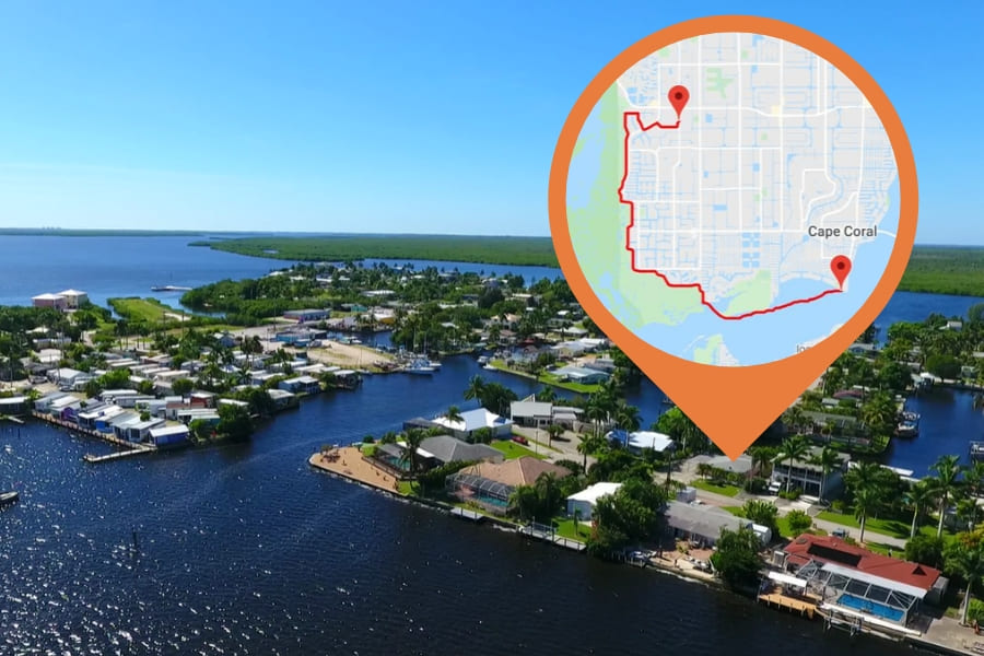
Boating is a popular way to explore Southwest Florida at your own pace and enjoy nearly unlimited freedom. However, a little planning is necessary before you can head for idyllic islands and other destinations near Cape Coral. If you want to know how long it takes to get to your destination and which route to take, this tool from our cooperation partner is your perfect choice.

Just follow these 3 simple steps:
- Type in your starting point , e.g. our boat dock (3637 Del Prado Blvd S, Cape Coral, FL 33904) in close proximity to open waters. Of course, we will also deliver the rental boat to your house if you want to start from there. In this case, just type in your address. Auto-correction will do the rest. Notice that the tool only works if your house is situated at the saltwater canal with access to the Gulf of Mexico.
- In the dropdown menu on the right, choose a destination for your boat trip. For example, you can display the fastest route to the Gulf of Mexico via Cape Coral´s canals by selecting Little Shell Island. Vacationers based in the Northwest of the city choose Matlacha Pass Bridge (Pine Island Road) instead. This option will show you the quickest way to the Gulf of Mexico.
- Click on “Show” to see the length of the route in miles, as well as the estimated travel time . Most salt water canals are designated “No Wake zones”. Therefore, the tool accounts for a boat speed of 5 mph.
Please note that these calculations from iboatmap.com at this moment are only a rough estimate to help you get an idea of the length and duration of your trip. Of course, we will provide you with a GPS navigation system . This way you can plan your route in more detail after you have rented your boat.
Disneyworld in Florida – Walt Disney World Resort in Orlando

Dear customer, Cape Coral is a paradise for everyone who would like to experience the adventure of" boating "on their vacation. Have you ever watched manatees and dolphins in the wild? This and much more is possible here in Florida without a boat license. We will help you take a trip on the water that will make your vacation an unforgettable experience. Let us advise you and take advantage of our diverse services at unbeatable prices. Contact us now so we can show you how the adventure becomes a reality. Bastian Riedel - General Manager Speed-Dock
Related posts
Your Boat License in Florida – Rules and Regulations
- 29. April 2021
iPad Boat Navigation Software – Your Companion On The Water
- 28. April 2021

FAQ – Frequently asked questions
- 27. April 2021
Join The Discussion
Cancel reply.
You must be logged in to post a comment.
Florida Boat Course

Vacation Rentals

August 2024
September 2024, october 2024, november 2024, december 2024, january 2025, february 2025, august 2025, september 2025, october 2025, november 2025, december 2025, january 2026, february 2026, forgot password.
Please enter your username or email address. You will receive a link to create a new password via email.
Compare listings
Compare experiences.
IT WOULD BE NICE TO HAVE YOU ON BOARD;-)
SIGN UP FOR OUR NEWSLETTER AND RECEIVE $25 OFF FOR YOUR NEXT BOOKING
Thank you! Please enter the promo code FLORIDASTRONG in the booking process and get 20% discount on your booking!
There was an error while trying to send your request. Please try again.
captainscalcultor.com
Boat Travel Time Calculator
Introduction.
Efficient trip planning is crucial for boat enthusiasts, and understanding the travel time required for a journey is a key component. The Boat Travel Time Calculator is a valuable tool designed to simplify the process of estimating how long it will take to reach a destination by boat. In this article, we will explore the formula behind the Boat Travel Time Calculator, guide you on how to use it effectively, provide a practical example, address frequently asked questions, and conclude with the significance of accurate time estimations in the realm of boating.
The Boat Travel Time Calculator employs a straightforward formula to estimate travel time based on distance and average speed:
DistanceAverage Speed T r a v e lT im e = Average Speed Distance
This formula considers the distance to be covered and the average speed of the boat, providing an estimation of the time required for the journey.
How to Use?
Using the Boat Travel Time Calculator involves the following steps:
- Enter Distance: Input the distance of your boat journey in miles or kilometers.
- Enter Average Speed: Input the average speed of your boat in knots or any suitable speed unit.
- Click Calculate: The calculator will use the provided values to estimate the travel time.
- Interpret the Result: The calculated travel time represents the estimated duration it will take to complete the boat journey.
Consider an example:
- Distance: 100 miles
- Average Speed: 20 knots
Using the formula:
10020 T r a v e lT im e = 20 100
After calculations, the estimated travel time for the 100-mile boat journey is determined.
Q1: Why is knowing travel time important for boaters?
A1: Understanding travel time helps boaters plan their journeys effectively, manage fuel consumption, and estimate arrival times.
Q2: Does the Boat Travel Time Calculator account for variable factors like currents and wind?
A2: No, the calculator provides a baseline estimate. Actual travel time may be influenced by factors like currents, wind conditions, and other navigational considerations.
Q3: Can the calculator be used for different types of boats?
A3: Yes, the Boat Travel Time Calculator is versatile and applicable to various types of boats, from small recreational vessels to larger yachts.
Conclusion:
The Boat Travel Time Calculator is a valuable asset for boaters seeking to optimize their journeys. By providing a quick estimate of travel time, it facilitates efficient trip planning and enhances the overall boating experience. Whether you’re a recreational sailor or planning a more extensive voyage, the Boat Travel Time Calculator empowers you to make informed decisions and ensures that your journeys are not only enjoyable but also well-managed in terms of time and logistics.
Leave a comment Cancel reply
Save my name, email, and website in this browser for the next time I comment.
- USA +1 954 892 5009
- UK +44 (0)20 7193 5450
- Asia +66 6000 35434
- Crewed Yachts
- Destinations
Boatbookings Journey Planner
Calculate the distance, fuel consumption, and cost of your next boating trip.
Boatbookings have created the leading online yacht charter route planner, distance and fuel calculator, so you can see your exact cruising plan and itinerary in unrivalled detail. See how far it is between each place of interest and all the islands and towns you will pass on route. Your charter is in your hands!
All you need to do is 1 - search for your port, 2 - click "Start New Route" and click through the exact route you'll be taking. Then 3 - enter average speed and fuel consumption per hour, and everything is calculated for you! Full instructions here .
See our yachts in the British Virgin Islands | A guide to Cannes and the French Riviera | Yacht charters in Greece | Amalfi Coast Yacht Charters
- 1 - search for your port
- 2 - click through the exact route
- 3 - enter average speed and fuel consumption per hour
Top Charter Areas:

Complete directions:
Enter your embarkation point and click through the map with where you plan to go. A line will trace your route, and the distance is calculated at each click. Double click to finish. Then scroll below and enter the price of fuel, the cruising speed and consumption of your yacht - everything is calculated for you!
Here's an example of a week long Amalfi Coast crewed motor yacht itinerary , embarking in Naples, visiting Procida, Ischia, Capri, Sorrento and the Amalfi Coast, showing the route, distance, and projected cost of the cruise:

We also have a CO2 Emissions Calculator , so that you can calculate your yachting Carbon Footprint as well as buy carbon offsets. Click here to read all about low carbon yacht chartering .
Looking to rent a day boat ? See our sister site MyDayBoat.com for great prices, real time booking, and direct contact with the boat owner!
Anti spam We'd love to contact you by email about yachts, destinations and offers. Do tick this box if you are happy for us to do so.

No Obligation Travel Itinerary
Chartering Information
Charter distance and cost calculator!!
Why Charter a Yacht?
Yacht Charter Basics
Charter Pricing and Affordability
Yacht Charter Fees and Insurance
Frequently Asked Charter Questions - Yacht Charter FAQ
About Boatbookings
Why Charter With Boatbookings?
Yacht Charter Insurance
Crewed Yacht Charter Checklist
The Yacht Charter Experience - Getting the most from your boat rental
Boat Rentals Guide - how to Rent a Boat for a Charter Holiday Vacation
Yachting and Boating Glossary of Terms
Browse All Articles
Our most popular charter regions
- Caribbean Sea Charter Yachts
- Mediterranean Sea Charter Yachts
- Pacific Ocean Charter Yachts
- Thailand and Indian Ocean Charter Yachts
- Virgin Islands Yacht Charter
- Bahamas Yacht Charter
- Seychelles Yacht Charter
- Where We Charter
Several of the key worldwide chartering events of the year.
- Corporate Yacht Charter
- Event Yacht Charter
- Cannes Film Festival Yacht Charter
- Monaco Grand Prix Yacht Charter
- Charter Events in Cannes
- Weddings and Honeymoon Yacht Charters
- Family Charters with Children
- List your Charter Yacht on Boatbookings
Our International Specialized Sites
- Stunning Yachts Charter
- Boating News and Blog
- Boat Itineraries
- France location de bateaux
- Boten Verhuur, Boot Charter
- Boot Charter/Location de Bateaux
- Alquiler de Embarcaciones
- Turkiye Yat Kiralama
Rating: 4.9 / 5 calculated on 1294 reviews
- London +44 (0)20 7193 5450
- French Riviera +33 (0)9 70 46 39 79
- Ft Lauderdale +1 954 892 5009
- Thailand/Asia Pacific +66 6000 35434
General Email Contact: [email protected]
- © Copyright 2024 Boatbookings
- T's and C's
- Useful links
- Testimonials
- © Copyright 2024 Boatbookings | T's and C's | FAQ |
This website uses cookies --- I understand and accept
Cargo calculator
What’s distance & time.
It’s a logistics application created to estimate distances and times between sea routes under particular parameters.
How it works?
You insert your origin and destination and then the system displays data about distances and time estimates from SeaRates database.
What’s the information based on?
Open sources combined with information from various shipping lines and nautical agencies. This information has been collected for over ten years and is regularly updated.
Get your planning under control
Few professional shipping companies are able to answer this question “When will I get my shipment?” to the client’s satisfaction. Our transit time system lets you fill this gap in seconds The clean interface is visually appealing and easy to use. Keeping track of your delivery time is important if you want to provide clients with accurate estimates after order placement. This is what we’ve been doing at SeaRates for many years and are now sharing with the rest of the world!
Distance & Time made simple
Often customers are given a very rough estimate of their delivery. “It will take two to four weeks”, for example, or “it can be delivered by Friday if you place your order in the next 12 hours”. This gives a frame of reference to the customer, but all other things being equal, given a choice between several companies with similar prices, the customer will choose the one with the fastest delivery service. So precise information is always preferred, since it is often necessary to prepare or be personally present for the delivery. Not to mention that properly timing your delivery is crucial to avoid work gaps in production. Save yourself some unwanted trouble by installing our Distance & Times tool to help you compete in the marketplace!
Usually the transport companies integrate the app with Logistics Explorer to also provide customers with instant shipping rates from/to anywhere in the world. It can also be enhanced by Route Planner to also schedule shipments easier and track sea lines
Distance & Time
Make your site better by integrating tools from searates, shipping distance & time calculator.
Distance & Time is web application, which allows to calculate distances and transit time between two points using different modes of transport.

Choose language:
Sea route & distance
find start port:
find destination port:
start typing to see the suggestions
Distance: nautical miles
time at sea
Paste link in email:
© 2010-2023 Ports.com
Boat Travel Time Calculator
How do you calculate travel time on a boat?
To calculate travel time on a boat, you need to divide the distance to be traveled by the boat’s speed. The formula is:
Travel Time (in hours) = Distance / Speed
How long does it take to travel 1 mile by boat?
The time it takes to travel 1 mile by boat depends on the boat’s speed. For example, if the boat’s speed is 5 knots, it will take approximately 0.2 hours (or 12 minutes) to travel 1 mile.
How long does it take to go 50 miles on a boat?
The time it takes to travel 50 miles on a boat depends on the boat’s speed. For example, if the boat’s speed is 20 knots, it will take approximately 2.5 hours to travel 50 miles.
How long does it take to travel 20 nautical miles?
The time it takes to travel 20 nautical miles on a boat depends on the boat’s speed. For example, if the boat’s speed is 8 knots, it will take approximately 2.5 hours to travel 20 nautical miles.
Is there a Google Maps for boats?
Google Maps does not provide navigation specifically for boats. However, there are other marine navigation apps and software that are specifically designed for boating, such as Navionics and Garmin BlueChart.
How long does it take to travel 100 miles by boat?
The time it takes to travel 100 miles on a boat depends on the boat’s speed. For example, if the boat’s speed is 25 knots, it will take approximately 4 hours to travel 100 miles.
How long does it take to go 5 miles in a boat?
The time it takes to go 5 miles on a boat depends on the boat’s speed. For example, if the boat’s speed is 10 knots, it will take approximately 0.5 hours (or 30 minutes) to go 5 miles.
Is 400 hours on a boat a lot?
The number of hours on a boat is not the sole indicator of its condition. 400 hours can be considered relatively low for a well-maintained boat, but it depends on the age, type, and usage of the boat.
How far can you travel in a boat in a day?
The distance a boat can travel in a day depends on factors such as the boat’s speed, fuel capacity, and the number of hours spent underway. A boat with an average cruising speed of 25 knots can cover approximately 600 nautical miles in a day with 24 hours of continuous travel.
Is 350 hours on a boat a lot?
350 hours is generally considered relatively low for a boat, especially if it’s well-maintained. The number of hours on a boat should be considered in conjunction with its age and condition.
How long is a mile on a boat?
A mile on a boat is the same as a nautical mile, which is approximately 1.15 statute miles or 1.852 kilometers.
What is the distance covered by a boat in 4 hours 48 minutes?
The distance covered by a boat in 4 hours and 48 minutes depends on the boat’s speed. To calculate the distance, you can use the formula:
Distance (in nautical miles) = Speed (in knots) * Time (in hours)
How fast is 25 knots on a boat?
25 knots is equivalent to approximately 28.8 miles per hour (46.3 kilometers per hour) on a boat.
How many mph is 1 nautical mile?
1 nautical mile is approximately 1.15 miles per hour (mph).
How fast is 10 knots in nautical miles?
10 knots is equivalent to 11.5 miles per hour (18.5 kilometers per hour) in nautical miles.
Can you use your phone as a boat GPS?
Yes, you can use your smartphone as a boat GPS by using marine navigation apps that provide GPS functionality and nautical charts.
Is there a free marine navigation app?
Yes, there are free marine navigation apps available for smartphones, such as Navionics Boating, OpenCPN, and MarineTraffic.
Can I use a car GPS on a boat?
While you can use a car GPS on a boat, it may not be the best option for marine navigation. Marine GPS units and apps are specifically designed for boating and provide additional features such as nautical charts, tide information, and AIS integration.
Is 200 hours on a boat a lot?
200 hours is generally considered relatively low for a boat, especially if it’s well-maintained. The number of hours should be considered in conjunction with the boat’s age and condition.
What is the longest boat trip ever?
The longest boat trip ever recorded is likely the voyages of early explorers, such as Ferdinand Magellan’s circumnavigation of the world in the early 16th century. Modern long-distance boat trips may cover thousands of nautical miles and can take several months to complete.
How long does it take a boat to travel 500 miles?
The time it takes a boat to travel 500 miles depends on the boat’s speed. For example, if the boat’s speed is 20 knots, it will take approximately 25 hours to travel 500 miles.
Do boats have mileage or hours?
Boats are typically measured in hours of engine operation rather than mileage, as boats are primarily used in water, not on roads.
How long is a boat ride across the ocean?
The length of a boat ride across an ocean depends on the starting and ending points and the boat’s speed. Crossing major oceans can take several weeks to a few months.
How long should a boat be to cross the ocean?
There is no specific length requirement for a boat to cross the ocean. Many sailors have crossed oceans in boats ranging from 30 to 50 feet or more. The boat’s design, seaworthiness, and the crew’s experience are more important factors.
Can you live full time on a boat?
Yes, many people live full time on boats, either as liveaboards in marinas or as cruisers, traveling from place to place.
How long can a boat sit without running?
The time a boat can sit without running depends on factors such as battery capacity, fuel condition, and environmental conditions. Boats should be regularly maintained and started, especially if they will be sitting idle for an extended period.
How many hours is OK for boat motor?
The number of hours considered acceptable for a boat motor varies depending on the type of motor, maintenance, and usage. Well-maintained boat motors can last for thousands of hours.
How long does it take to travel 200 miles by boat?
The time it takes to travel 200 miles by boat depends on the boat’s speed. For example, if the boat’s speed is 15 knots, it will take approximately 13.3 hours to travel 200 miles.
Is 1000 hours on a boat a lot?
1000 hours is generally considered moderate usage for a boat motor. Well-maintained boat motors can last for thousands of hours before needing significant overhauls.
What is the minimum size boat for ocean travel?
There is no strict minimum size for a boat to travel in the ocean, but larger boats generally offer more comfort and safety for extended ocean passages. Boats around 30 feet or larger are often preferred for ocean travel.
Should I buy a boat with 500 hours?
The number of hours on a boat should be considered along with its age and maintenance history. 500 hours is generally considered low for a well-maintained boat.
How long is too long for a boat to sit?
Leaving a boat sitting idle for an extended period without proper maintenance can lead to issues with the engine, battery, and other systems. Regular maintenance is essential to keep a boat in good working condition.
What is considered high mileage for a boat?
The concept of high mileage is not commonly used for boats. Instead, the number of engine hours is typically used to gauge usage and wear.
How far can a motor boat go in 6 hours?
The distance a motor boat can cover in 6 hours depends on the boat’s speed. For example, if the boat’s speed is 25 knots, it can travel approximately 150 nautical miles in 6 hours.
How far can the average boat travel?
The average boat’s travel distance depends on factors such as fuel capacity, boat type, and speed. Many recreational boats have ranges of 150 to 300 nautical miles on a full tank of fuel.
How do you calculate hours on a boat motor?
To calculate the number of hours on a boat motor, you can use the boat’s hour meter, if equipped. If there is no hour meter, you can estimate based on usage, keeping track of engine run time.
How fast is 20 knots on a boat?
20 knots is approximately 23 miles per hour (37 kilometers per hour) on a boat.
How fast is 15 knots on a boat?
15 knots is approximately 17 miles per hour (27 kilometers per hour) on a boat.
How fast is 60 knots on a boat?
60 knots is approximately 69 miles per hour (111 kilometers per hour) on a boat.
Is 69 mph fast for a boat?
Yes, 69 mph is considered fast for a boat, especially for recreational boats. Boats capable of such speeds are often high-performance models.
Why do boats use knots instead of mph?
Boats use knots instead of miles per hour (mph) because a knot is a nautical mile per hour, which is a standard unit of speed in marine navigation.
Why do boats use knots instead of miles?
Boats use knots instead of miles because a knot is a unit of speed that is directly related to nautical miles, which are commonly used for marine navigation.
How many miles is 20 knots per hour?
20 knots per hour is approximately 23 miles per hour.
Why is a nautical mile longer than a mile?
A nautical mile is longer than a statute mile (land mile) because it is based on the circumference of the Earth. A nautical mile is equal to one minute of latitude, which is about 1.15 statute miles.
What speed is 30 knots in mph?
30 knots is approximately 34.5 miles per hour.
How deep is a fathom?
A fathom is a unit of measurement used for depth in nautical contexts. One fathom is equal to 6 feet or approximately 1.8288 meters.
Why are there 1760 yards in a mile?
The mile is based on historical measurements from the Roman Empire. The Roman mile was 1,000 paces, and each pace was two steps, totaling 5,000 Roman feet. The British Empire later standardized the mile as 5,280 feet, which is 1,760 yards.
How far are territorial waters?
Territorial waters extend up to 12 nautical miles from a country’s coastline. Within these waters, the country has sovereignty and control over the airspace and sea.
Is there Google Maps for boats?
What is the best navigation system for a boat?
The best navigation system for a boat depends on the specific needs of the boat owner. Common options include dedicated marine GPS units, marine navigation apps for smartphones and tablets, and integrated navigation systems with chartplotters and radar.
How can I have Wi-Fi on my boat?
To have Wi-Fi on your boat, you can use a marine Wi-Fi router that connects to a cellular network or a satellite internet system. Some marinas also offer Wi-Fi access for boaters.
What lights do I need on my boat?
Boats are required to have specific navigation lights based on their size and type. These lights help make the boat visible to other vessels at night and in low visibility conditions. Common lights include red and green sidelights, a white stern light, and an all-around white light for anchoring.
Is Navionics boating free?
Navionics Boating offers both free and paid versions. The free version provides basic charting and navigation features, while the paid version offers additional features and access to more detailed charts.
Can you use a GPS instead of a marine chart?
While GPS devices provide position information, they are not a substitute for marine charts. Marine charts provide essential information about water depths, hazards, navigation aids, and other critical details for safe navigation.
Can I use my iPhone as a GPS on my boat?
Yes, you can use your iPhone as a GPS on your boat by using marine navigation apps that provide GPS functionality and nautical charts.
Can I use a tablet for boat GPS?
Yes, you can use a tablet as a boat GPS by installing marine navigation apps that are compatible with tablets and provide GPS and charting functionality.
Do I need boat GPS?
A boat GPS is not strictly required, but it is highly recommended for safe navigation, especially when venturing into unfamiliar waters. A GPS helps boaters track their position, plan routes, and avoid hazards.
What is the most common cause of boat breakdowns?
The most common cause of boat breakdowns is often related to engine issues, such as fuel problems, electrical failures, or cooling system malfunctions.
What is considered an old boat?
The definition of an old boat varies depending on the context and the type of boat. For some boat owners, a boat that is 10-15 years old may be considered old, while for others, boats built before the 1980s or earlier may be considered old.
How many miles can a boat cover in a day?
The distance a boat can cover in a day depends on factors such as the boat’s speed, fuel capacity, and the number of hours spent underway. A boat with an average cruising speed of 25 knots can cover approximately 600 nautical miles in a day with 24 hours of continuous travel.
How long was a boat trip across the Atlantic?
Historical boat trips across the Atlantic, such as those undertaken by early explorers, could take several weeks to several months, depending on the wind and weather conditions.
How long was a boat ride across the Atlantic?
Historical boat rides across the Atlantic, such as those undertaken by early explorers, could take several weeks to several months, depending on the wind and weather conditions.
How long does it take to travel 100 miles on a boat?

GEG Calculators is a comprehensive online platform that offers a wide range of calculators to cater to various needs. With over 300 calculators covering finance, health, science, mathematics, and more, GEG Calculators provides users with accurate and convenient tools for everyday calculations. The website’s user-friendly interface ensures easy navigation and accessibility, making it suitable for people from all walks of life. Whether it’s financial planning, health assessments, or educational purposes, GEG Calculators has a calculator to suit every requirement. With its reliable and up-to-date calculations, GEG Calculators has become a go-to resource for individuals, professionals, and students seeking quick and precise results for their calculations.
Related posts:
- Travel Baseball Age Calculator
- Travel Agent Commission Calculator
- Sleep Calculator for International Travel
- Why Is It So Expensive To Travel From The Mainland Us To Guam? A Flight To Thailand From Nyc Is Half The Cost
- How Much Time Does it take for Sound to Travel 1 Foot?
- Why Is It So Expensive To Travel From The Mainland Us To Guam?
- Jon Boat Weight Capacity Calculator
- Boat Fuel Tank Size Calculator
- Boat Trailer Tongue Weight Calculator
- Boat Shipping Cost Calculator
- Boat Shipping Cost Calculator Canada
- Boat Building Cost Calculator
- Boat Fuel Cost Calculator
- Boat Ownership Cost Calculator
- Boat Dock Cost Calculator
- Boat Lift Size Calculator
- Boat Battery Size Calculator
- Boat Lift Capacity Calculator
- Boat Fuel Burn Calculator
- Boat Trailer Size Calculator
- Boat Bottom Paint Calculator
- Topsides Boat Paint Calculator
- Boat Propeller Calculator
- Fishing Boat Propeller Calculator
- Pontoon Boat Propeller Calculator
- RC Boat Propeller Calculator
- Sailing Boat Propeller Calculator
- Narrow Boat Propeller Calculator
- Electric Boat Propeller Calculator
- Inboard Boat Propeller Calculator
- Jet Boat Impeller Calculator
Leave a Comment Cancel reply
Save my name, email, and website in this browser for the next time I comment.
- Ports Distances
- Voyage Calculator
Port of Departure
Port of arrival.
Not calculated yet.
DESCRIPTION
SEA DISTANCES / PORT DISTANCES - online tool for calculation distances between sea ports.
More than 4.000.000 distances
More than 4000 sea ports.
MARINE VESSEL TRAFFIC
CORONAVIRUS SHIPS
PLANS & PRICES
FLEET ANALYSES Coming soon
Sea Distance Calculator

Ship Traffic .net
Sea Distance Calculator
Shiptraffic.net is a maritime website monitoring ship traffic in 14 different types of geo regions like Seas, Straits, Canals, Sounds, Reefs etc., stating their geographical coordinates by latitude and longitude around the world. We show ships current positions and marine traffic through the embedded maps of marinetraffic.com and vesselfinder.com facilitating our users with full screen option and display of Google map view. These live maps are of AIS type and present vessels’ movements with a refresh rate of a minute or two. Our Dual Map functionality offers unprecedented comparison and back up information regarding ships’ traffic side by side. Thus, you can follow and observe maritime distress situations, naval exercises, war conflicts, sinking of ships locations, drifting vessels and salvage of crews and passengers. Related to each geographical marine site and object there are buttons for photos and video, directing you to Google Images and YouTube. Below each map and maritime geo object we placed an image of the marine traffic density for clearer representation of the marine routes and ship lanes that pass around and across. In addition, precious information about the past and present thereof is located at the end of each page consisting of prolific Wikipedia information. As a responsible to all aspects of maritime deeds website shiptraffic.net utilizes Sea Distance Calculator from port to port, Nautical Chart, Interactive map of the major 300 rivers, seas and ocean objects and regions, Maritime Locator useful to spot, find out and contact Shipyards, Agents, Ship Suppliers, Bunkerers and nearby Sea Ports in the region of interest, a handy marine Weather map is always at the service of mariners and seafarers. For some of the marine objects we have provided the function Ports Nearby where you can see in nautical miles how remote these ports are from the place where that 14 objects are located.
Sea Distance Calculator, Transit Time, Port to port distances, Setup Vessel Speed in Nautical Miles, Custom Map Points, Date of Departure and Arrival.
Sea Distance Calculator №2
How to use the Sea Distance Calculator ?
How to choose Departure and Arrival points on the map with calculator's target buttons
Preview of Nautical Sea Distance Calculator Result
20 emails/day for more ask
Send 0 emails out of 20 today
Sailing Time Calculator Online
Introduction:
A Sailing Time Calculator is a useful tool for anyone involved in marine travel or transportation. The calculator helps to determine the estimated time it will take to travel a specific distance at a certain speed on water. This is particularly valuable for planning voyages, optimizing routes, and managing shipping schedules.
The Fundamental Formula:
The underlying principle of a Sailing Time Calculator is a basic formula from physics – Time = Distance / Speed. This formula is used to calculate time when distance and speed are known.
In the context of sailing, this formula becomes:
Time (in hours) = Distance (in nautical miles) / Speed (in knots)
Working of the Sailing Time Calculator:
To understand the operation of the calculator, let’s follow a step-by-step process:
Step 1: User Input The user enters the two necessary parameters into the calculator: Distance and Speed. The Distance is the total nautical miles that will be covered in the journey. The Speed is the cruising speed of the ship or boat, usually measured in knots.
Step 2: Validation Before performing any calculations, the input values are checked for validity. Both Distance and Speed should be non-zero positive numbers for the calculation to make sense.
Step 3: Calculation Once validated, the calculator performs the simple calculation using the formula mentioned above. It divides the Distance by the Speed to find the Time required for the journey.
Step 4: Display Results The calculated Time is then displayed to the user. It’s usually in hours, but may also be translated into days, weeks, etc., based on the magnitude of the journey.
Let’s consider an example. Suppose a ship is sailing a distance of 200 nautical miles at a speed of 20 knots. Here’s how the Sailing Time Calculator will determine the time for the journey:
Time = Distance / Speed = 200 nautical miles / 20 knots = 10 hours
This means the ship will take approximately 10 hours to complete its journey, assuming constant speed and no other influencing factors.
Conclusion:
A Sailing Time Calculator is an essential tool for maritime operations, providing vital information to facilitate effective planning and time management. It operates based on simple principles of speed, distance, and time but has a significant impact on the efficiency of sailing activities. However, it’s important to remember that actual sailing conditions include various other factors like sea conditions, wind speed, and direction, which might affect the actual travel time.
🚀 Upgrade Your Calculations with AI-Powered Precision!
Solve any problem in a snap with Calculatorshub Ai Calculator.
Related Calculators
USCG Tonnage Calculator Online
No Decompression Limit Calculator Online
Bulk Reef Calculator Online
BRS GFO Calculator Online
Seatime Calculator Online
Pool Water Delivery Calculator Online
Jet Boat Impeller Calculator Online
Travel Time by Boat Calculator Online
Ship Distance Calculator Online
Marine Calculator Online
Leave a Comment Cancel reply
Save my name, email, and website in this browser for the next time I comment.

- RYA First Aid Course
- RYA Professional Practices & Responsibilities Course
- RYA VHF radio (SRC) Classroom Course
- VHF pre-course learning
- RYA VHF/SRC exams
- RYA CEVNI ICC (inland waterways)
- RYA Safeguarding 'Safe & Fun' course
- Navigation Theory Refresher
- RYA Essential Navigation & Seamanship Classroom Course
- RYA Day skipper shorebased theory classroom course
- RYA Coastal skipper / Yachtmaster Offshore theory classroom course
- Online courses - FAQ
- Online test page
- RYA Jet ski (PWC) Proficiency Course
- Planning a Jetski Adventure
- Safety & Patrol Jetski Operator Training
- RYA Jet ski (PWC) Instructor Course
- RYA Jet ski (PWC) Instructor Conversion Course
- RYA Powerboat level 1 course
- RYA Powerboat level 2 Course
- International Certificate of Competence
- Youth RYA Powerboat Courses
- Private Powerboat Lessons
- Private RYA Powerboat Courses
- RYA Powerboat Level 1 Course (Own Boat)
- RYA Powerboat Level 2 Course (Own Boat)
- Bespoke Tuition (Own Boat)
- Introduction to Night Powerboating
- RYA Powerboat Intermediate Course
- RYA Tender Operator Course
- RYA Advanced Powerboat Course
- Advanced Powerboat Exam CoC
- RYA Powerboat instructor Skills Assessment
- RYA Powerboat instructor Course
- RYA Yachtmaster Instructor to Powerboat Instructor Conversion Course
- RYA Advanced Powerboat instructor Course
- RYA Jetski (PWC) instructor Course
- RYA Powerboat to Jetski (PWC) instructor conversion Course
- RYA Powerboat Instructor Workshops
- RYA Jetski Instructor Workshops
- RYA Jetski (PWC) proficiency /licence course
- Onboard PWI Booking & Terms
- PWI student page
- Student details
- Working on a Superyacht
- Superyacht Jetski Lifting Slings
- Commercial Boating
- RYA Course Gift Vouchers
- Christmas Gift Vouchers
- Our Location
- Teaching craft
- Customer Reviews
- Our RYA Training Team
- Local Accommodation
- Poole Harbour Boating Guide
Calculating time using a nautical chart
1 knot = 1 nautical mile per hour
D ÷ S = Time (in decimals of an hour)
To convert the decimals into minutes x 60
An example:
How long will it take to travel 3.2 nautical miles at 10 knots?
3.2 ÷ 10 knots = 0.32 x 60 = 19.2 minutes
Fuel Consumption:(Power Vessels)
Dependant on your speed, engine type, horsepower etc.
But a good rule of thumb is 1/3 out, 1/3 back and 1/3 in reserve
* See Measuring distance on a nautical chart tutorial here

- Scroll to top
Map Your Route Yacht distance calculator
Map your route.
You can plan your sailing journey down to the last detail with our interactive distance calculator. Select points on the map below to plot your route. Enter the speed, fuel consumption, and fuel cost to determine the total cost of the trip.
Carbon Offsetting:
Total distance.
0 Nautical Miles
0 Kilometers
0 Fuel Consumed (litres/hour)
0 Total Cost
Explore the world of chartering
Your perfect adventure awaits on a luxury charter yacht. Whether you are new to the world of yacht charters or a seasoned pro, our yacht consultants are here to help at every stage of your yachting journey.

Luxury Yacht Charters with TJB Super Yachts: Uncover Remarkable Experiences.

How to Charter A Superyacht
Explore the thrills of chartering a superyacht with TJB Super Yachts. Learn how to charter a yacht and discover the TJB Super Yachts difference here.

- Concierge Services
Welcome to the world of bespoke luxury lifestyle: yacht concierge services powered by TJB Super Yachts.
CONTACT OUR TEAM
Interested request a call-back.
By filling out this form you will receive communications on our services and offers. You can unsubscribe at any point in the future from our mailing list using the ‘unsubscribe’ link on any of our emails. In order to understand how we use and protect your personal information, please read our privacy policy .
Share this page
- All Superyachts for Sale
- Motor Superyachts
- Sailing Superyachts
- Buying A Superyacht
- Selling a Superyacht
- Buying a Yacht FAQs
- Selling a Yacht FAQs
- Why choose us?
- Building a Custom Superyacht
- Build a Semi-Custom Superyacht
- Yacht Management
- Yacht Marketing
- All Superyachts for Charter
- How To Charter A Yacht FAQS
- Design Your Perfect Itinerary
- Mediterranean
- Indian Ocean & Asia
- South Pacific
- The Rest of the World
- Where Can I Travel?
- Summer Experiences
- Winter Experiences
- Wellness and Fitness
- Parties and Event Planning
- Adventures and Experiential Travels
- Yacht and Boat Shows
- Sporting Events
- Corporate Events
- Social & Luxury Events
- Sailing Regattas
- Charter Itinerary Builder
- Distance Calculator
- In the press
- Superyacht Charter Fast Facts
- Superyacht Sales Fast Facts
- Meet Our Team
- Our Offices
- Current Role
Privacy Overview
Nautical Mile Calculator
What is a nautical mile, how many miles in a nautical mile nautical mile vs mile, how many kilometers in a nautical mile, what is knot, how to convert knots to nautical miles, other conversion tools.
The nautical mile calculator is a handy tool to help you calculate the distance from and to nautical miles (nmi) .
Provide the distance in miles, kilometers, or any other unit, and the result of the conversion will show up instantly.
You can also use this nautical mile calculator to calculate the traveled distance based on vessel speed and sailing time . If sailing is your pet subject and you're curious about dedicated tools with more advanced options, you might find helpful our boat speed calculator or hull speed calculator .
Please keep reading to learn more about the interesting unit of distance; the nautical mile.
A nautical mile is a unit of distance . Nautical miles are commonly used in air and marine navigation.
This unit is based on the circumference of the Earth and is equal to one minute ( 1 / 60 1/60 1/60 of a degree) of latitude. You can calculate the distance with longitude and latitude with our tool if you don't know the distance in nautical miles but you have the coordinates of two points.
A nautical mile can also be described as the distance traveled over one hour with a speed of one knot . Actually, the knot is a derived unit from a nautical mile, not the other way around.
If you want to learn more about speed conversion used in nautical applications, check out our knots to mph converter .
Comparing nautical mile vs. mile, the former is longer than the latter by approximately 15%. So to convert from nautical miles to miles, multiply the former by 1.15078.
- nmi \text{nmi} nmi stands for a nautical mile; and
- mi \text{mi} mi stands for a standard land mile.
One nautical mile is equal to 1.852 kilometers (or 1852 meters). To convert nautical miles to kilometers, multiply the former by 1.852.
- km \text{km} km is a kilometer unit.
Knot (kn) is a unit of speed . One knot equals one nautical mile per hour.
The knot unit is used mainly in shipping, aviation, and meteorology.
The unit's name originates from the old method of measuring sailing speed: a piece of wood was tightened to a rope and thrown overboard into the water. The wood drifted on the water in one place, unwinding the cord from the deck of the sailing away ship. There were knots on the rope in regular intervals. The sailing speed was calculated on the number of knots unrolled in a given time.
Calculating knots to nautical miles is as simple as multiplying the number of knots by the time of sailing.
- kn \text{kn} kn stands for a knot;
- h \text{h} h is a time in hours.
Besides the nautical mile calculator, there are many other unit conversion tools on our website that you might find helpful. For example:
- Mile converter ;
- Steps to miles calculator ; or
- Kilometers to miles calculator .
Converting from nautical miles to miles or vice versa, calculating knots to nautical miles, or doing other math-related operations is a breeze with our vast collection of calculators and converters.
If you find our nautical mile calculator useful, please consider sharing it on social media.
Time to hours conversion
Us to eu shoe size converter.
- Biology (99)
- Chemistry (98)
- Construction (144)
- Conversion (292)
- Ecology (30)
- Everyday life (261)
- Finance (569)
- Health (440)
- Physics (508)
- Sports (104)
- Statistics (182)
- Other (181)
- Discover Omni (40)
- Pontoon Boats
- Personal Watercraft
- nauticalknowhow
- Nautical Knots
- Tools and Calculators
Estimating Time of Arrival

Some people don’t like to live by a schedule. They come and go whenever. Making a plan is often difficult with someone like this. You want to have dinner, and they come over whenever. If you’re serious about boating, this won’t work. You need to understand how to calculate an estimated time of arrival. Also, how to stick to it.
In many places, if you want a deck license you must be able to calculate time of arrival. And just in general, it’s good to know. Even a casual boater should have some idea of times and distances. This is helpful not just for you but for others as well. Officials at the marina may need to know your estimated time of arrival. Likewise, friends and family will probably need this as well. Finally, in an emergency, the U.S. Coast Guard can make use of this information.
Let’s take a look at what ETA means. Also, the best way for you to calculate your estimated time of arrival. And then finally, why it’s even important as well as other factors to consider.
What is ETA?
ETA stands for estimated time of arrival. It sounds simple, and in some respects it is. You are leaving the marina and you want to reach your friend’s cabin to do some fishing. You look at the distance between the two. You figure how fast your vessel travels . You get a rough idea of the time it will take.
Estimated time of arrival is something nearly everyone calculates all the time. This is on boats and on land. You tell a friend you’ll be at their place in 10 minutes. You want to leave the house 15 minutes before a movie starts so you can see the previews. It’s usually a very simple estimation.
When it comes to boating, estimated time of arrival can be more involved. You have additional factors to consider. Navigation times are not always consistent. And whether you are in a vessel under power or sailing also matters.
If the weather is not being cooperative, estimated time of arrival can be thrown off. If you have trouble navigating out of the marina, this can also throw off your time of arrival. For instance, if you get stuck waiting for another vessel to move.
In very simple terms, your estimated time of arrival is just that. It’s the time that you plan to arrive. You need to factor in a few key elements to solve the equation.
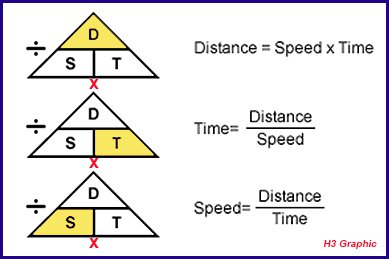
What is the Formula to Calculate ETA?

There are three elements in any equation to determine an estimated time of arrival. Any equation like this can be solved when you have two of the three factors. Once you know any two, the third can be easily determined.
Distance: This is the distance between where you are and where you plan to go. On the water you’re going to measure this in nautical miles. There can be mitigating factors in how this number is determined. For instance, let’s say you need to navigate around certain obstacles. This could add distance to your calculation. A trip on the water may not always be a straight line.
Speed: This is how fast you plan to travel from your starting point to the end. If your vessel is under power, this is usually very easy to determine. If you are sailing and relying on wind, it can be harder to figure.
Time: This is what you need to solve for. In an estimated time of arrival equation, it is a given you know distance and speed. In terms of simple math, you could solve speed if you knew time and distance. You could solve distance if you knew speed and time.
Distance = Speed x Time
Speed = Distance/Time
Time = Distance/Speed
This little diagram can help you remember how to work the numbers if you’re not sure. When you want to figure out any of those numbers, just cover the letter up with a finger. What’s left is the formula to solve it.
When it comes to estimated time of arrival, we need that last equation. So we’re going to be looking at distance divided by speed to solve. Let’s try an example using the formula.
You want to reach your friend’s cabin. It’s 29 nautical miles from your marina. You plan to head out at a speed of 12 kts. Not too fast, not too slow. Punch in the equation and we can see how it works.
Time = 29/12 = 2.42 hours.
IMPORTANT: The way that’s written can be read as two hours and 42 minutes. That is not the correct time solution. It is 2 hours plus 42/100 of an hour. It’s a fraction, not a time based on a 60 minute hour.
As an example, let’s say the speed was 17 kts. Then you get this equation;
Time = 29/17 = 1.71 hours. Obviously this is not one hour and seventy-one minutes, no one writes time like that. Instead, it’s one hour and 71/100 of an hour. So now we can convert these to a more understandable time. Let’s go back to our 2.42 hours.
In order to determine minutes, you simply multiply your fraction by 60. In this case, 0.42 x 60. The answer is 25.
Time = 2 hours and 25 minutes is the solution.
For our second example, at 17 knots, you get 43 minutes. The estimated time of arrival in this case would be 1 hour and 43 minutes.
Once you have this figured out, you can determine when you need to leave port to meet your estimated time of arrival. Let’s say in our example you wanted to be at your friend’s cabin for lunch at noon. You know the trip is going to take you 2 hours and 25 minutes. Convert that to minutes and you have 145 minutes.
12:00pm – 145 minutes (2 hours and 25 minutes) = 9:35 am. So you want to make sure you’re leaving the marina at 9:35 in the morning if you plan to make your lunch date.
Just as a point of confirmation, let’s calculate in reverse. As we said, if you know any two numbers you can determine the third in the formula. So let’s say your friend was waiting for you. They know your trip took two hours and 25 minutes. They know you were travelling at 12 knots. Now they want to know how far you travelled. So they can do the distance calculation with this formula.
Distance = 12 kts x 2.42 hours
Distance = 29 nautical miles
So the equation did the reverse, and as you can see, we have the same distance. You travelled 29 nautical miles to your destination. To round it out, let’s calculate for speed.
Speed = 29 nautical miles/2.42 miles
Speed = 12 knots
If you’re ever unsure of your math, this is a good way to check. Do one of the other equations with your number punch in. If you get the same results for time, distance, or speed, you’re good. That means you did your math correctly. If your numbers are way off, then you may have made a mistake. Run the calculation again to double check. In a pinch, have a friend do it. Sometimes a fresh set of eyes can pick up a miscalculation.
If you punch in any of the equations yourself, you’ll see the numbers are slightly off. For instance, 29/2.42 comes out to equal 11.9834710744. Obviously that’s a needlessly long number. It’s so close to 12, you just round it up in the solution. Remember, Estimated is the key word in Estimated Time of Arrival.
Understanding Distance Calculations
This calculation works with knots. Knots are measured in nautical miles and they are not the same as miles on land. When you travel at a speed of one knot you are actually going at 1.15 miles per hour. So how do you calculate for time if you measure speed in miles per hour?
The fact is not everyone is capable of measuring speed in knots right away. If you’re new to boating a knot is as confusing as a parsec or a hectare. But you can convert miles per hour to knots easily enough. It’s good to have a calculator on hand for this. Fortunately, if you have a smart phone you have a calculator. That makes the equation easier.
1 mile/hour = 0.868976 knots (kts). So if your boat is travelling at 20 miles per hour, you’re going at about 17 knots.
Calculating ETA in a Sailboat

Figuring out your estimated time of arrival when you have an outboard is not very hard. The equation lays it all out very simply. But you may be wondering what to do in a sailboat. If you rely on wind, how can you determine your ETA? You can’t set a specific speed for wind, right?
Basically, when you’re on a sailboat, you need to calculate an estimated time of arrival on the fly. Once you’re underway, it’s easy enough to calculate cruising speed. In fact, you probably have a GPS that does it for you.
With a little practice, you should be able to gauge wind speed before you set out. This will help you determine what speed your sailboat is likely to be sailing at. From there it’s the same equation all over again.
Just remember, a sailboat has an average cruising speed of around 4 to 6 knots. But you can certainly get up around 15 knots as well. The calculation works the same regardless of speed or type of vessel.
Calculating ETA in a Small Boat

Now what happens if your vessel doesn’t have an engine? And it doesn’t even have sails? Let’s say you’re out on a bass boat. Maybe an old canoe. You paddled this thing out onto the water. How do you calculate ETA then?
Well, first and foremost, you have grit. Making a trip anywhere in a boat under manpower is an undertaking. For the most part. Estimated time of arrival isn’t usually calculated for boats of this size. That said, as a canoer or kayaker on a long trip, it may be important.
If you head out in a kayak and want an accurate estimated time of arrival, GPS is vital. The satellites can track your position at different points on your journey. Based on that distance your travel over a certain time, your speed can be determined. From there you can, of course, calculate an ETA.
Small boat estimated time of arrival is harder than many people think. Without GPS it is all but impossible. Even with GPS it is an in-the-moment thing. It would be very hard to calculate ahead of time. That’s not to say it’s impossible, but you need information about your route. For instance, if you’re taking a kayak in a river with a rapid current, this greatly affects speed. Does the current change at different times of year? When was it measured last?
There are many factors that will affect ETA for a small boat. Even ones in your control can alter the final number. If you’re tired your ability to paddle may suffer. Even the length of your paddles affects estimated time of arrival.
Portage times, complications along the way and more affect small boat ETA. In many ways it is far more complex than arrival times on open water.
The other key difference with many small boat trips is location. You are in a position in the water to get to land much more easily. If things get complicated or dangerous, you can go to shore. Rivers are rarely so broad that you can’t find a safe place to tie your boat up.
Why is ETA Important?

Estimated time of arrival has a number of benefits. The most obvious is you’re going to know when you’ll get to your destination. For many boaters, the big questions are how far, how fast, and how long. That’s distance, speed, and time all over again. If you’re just pleasure boating then it may not be that important. But when you need to get somewhere, it really is.
ETA is also an important thing for those on shore to know. You want to have an ETA as part of your float plan if at all possible. Friends and family will know when you expect your arrival so it makes planning easier.
The biggest benefit of a calculated ETA is what it can mean for search and rescue. If people know to expect you at 3:00 and you don’t arrive, efforts can start right away. With no definite ETA you could be missing for hours and no one would know. It may take as much as day before someone realizes there’s a problem. Consider ETA a safety feature.
The Coast Guard can use your ETA to determine where and when things may have gone wrong. They can calculate your route and figure out what may have happened to you in the event of an emergency.
Factors that Affect ETA

The biggest thing to remember about ETA is that it is estimated time of arrival. It is not definite time of arrival. A lot of factors can throw your ETA off. Sometimes this can be quite drastic. While it is impossible to plan for the unexpected, you can be aware of it. Any of these factors may alter your ETA.
Weather: It’s always a good idea to check the local weather forecast before going boating. Having a working radio to monitor changing conditions is also key. Still, even the best laid plans can go awry. If the weather kicks up suddenly, you can be left in the lurch. Weather could inhibit your ability to travel at the planned speed. Fog will require you to slow down considerably, for instance. Heavy winds may end up pushing you off course. Rough seas could be so bad you may have to turn around entirely. Planning will help mitigate this. But it’s still a possible obstacle to be aware of.
Obstructions: This is a rare concern, but not unheard of. It’s much more prevalent if you are travelling narrow channels. Or in a crowded marina. You may have to wait for other vessels to clear the way. If you are in a small boat, something as simple as a downed tree could alter your course drastically.
Sandbars, reefs, debris and more can wreak havoc with a boat on the water. In the worst circumstances, you can suffer hull damage and end up taking on water. You may also find yourself run aground and in need of aid. Make sure you know the proper light signals and sound signals. Call for help when you need it. It’s always better to be safe than sorry.
Equipment: Most of the time ETA is calculated under ideal circumstances. You only have those three numbers to work with, after all. But things can go wrong. Electronic failure on your boat could shut things down. Maybe your engine overheats. Or it could run out of gas. Propeller damage or hull damage could also arise. You could have an issue with your sails or paddles.
It’s always good to be prepared for these unexpected emergencies. Checking fuel and oil before you depart is something you should always be doing. Likewise your batteries, lines, and sails. Still, accidents do happen. Things get overlooked. Any of these pieces of equipment could malfunction. In that case, you may end up stranded.
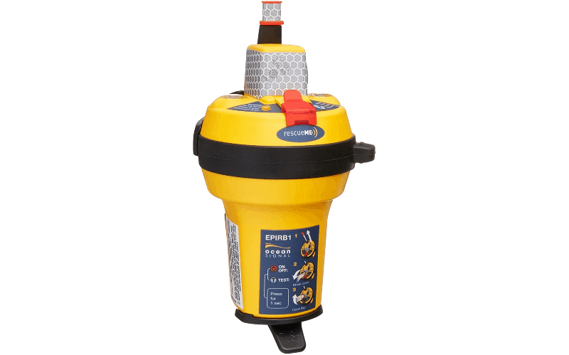
Make sure your radio is in good working order any time you head out. An EPIRB is also a good idea in case of emergencies.
Other Boaters: We already mentioned the issue related to having to wait for other vessels. You need to follow the rules of the road out on the water. Give way when required to other vessels. Especially larger boats. It’s never a good idea to test your luck against a boat that can crush you in its wake.
Beyond that, you may find an issue with another boater. If you get a signal from another boat in distress, you may have to change course to help. If there is a Man Overboard situation and you are the nearest vessel, you need to act. Obviously this is going to alter your ETA.
Emergencies: You never know what may happen when you hit the open water. It’s the same as anywhere else in life. You or a passenger may suddenly fall ill. Heart attack, food poisoning, a broken bone after slipping. Things happen all the time.
You should have an emergency first aid kit on board all the time. Cuts, scrapes and minor breaks can be dealt with when they happen. This will buy you the time you need to get proper medical assistance for any problems.
Make sure you and every other passenger knows where emergency equipment is located. This includes things like life jackets and personal flotation devices. You should all know how to use the VHF radio , and to turn it to Channel 16 in case of emergencies.
You’ll need a fire extinguisher on board as well. Everyone should know its location and how to use it.
Emergencies are just that, emergencies. They are unpredictable and unexpected. They can take many forms. And they can drastically alter your estimated time of arrival.
Personal Choices: Unless you’re on a very strict schedule, you may just want to have fun. Maybe you’re out fishing for a few hours. Your ETA is 4:00. When 3:30 rolls around you decide it’s time to head in. And just at that moment, you hook a monster. Are you going to let it go to meet your ETA? Probably not. It’s unlikely anyone will fault you for that, either.
Boating is supposed to be fun and relaxing. So if you’re having fun and relaxing, a schedule can sometimes be sacrificed. But, in these cases, you should alert someone. Use your radio or a cell phone to let whoever is expecting you know. Plans change, but it’s polite to keep everyone in the loop. Also, it can help avoid situations where people think an accident has happened.
The Bottom Line
Estimated time of arrival is a handy tool to have at your disposal. It lets you plan your boat voyage more efficiently and, in turn, you whole day. Remember that it’s not a rule, though. If your ETA is noon and you’re going to miss it by a large margin, don’t panic. Boating responsibly is still job number one. If something has altered your estimated time of arrival, that’s OK. If possible, radio or call others to let them know you’re behind. If not, just roll with it.
What you don’t want to do is try to overcompensate at the risk of safety. Don’t go faster than is reasonable. Don’t try to skirt any of the rules of the road to save time. Better to be a little late and get there in one piece.
As we have said, the estimated time of arrival is just an estimate. It’s OK to be a little off. Sometimes even a lot off. Especially if the difference is having an accident and needing emergency rescue.
My grandfather first took me fishing when I was too young to actually hold up a rod on my own. As an avid camper, hiker, and nature enthusiast I'm always looking for a new adventure.
Categories : Tools and Calculators
Leave a Reply Cancel reply
Your email address will not be published. Required fields are marked *
Save my name, email, and website in this browser for the next time I comment.
More in Tools and Calculators
Boat Speed Calculator

Boat Distance Calculator

How Water Pressure Works: Water Pressure Calculator Included

TVMDC Explained

The People’s Poncho Review and Ratings

Oru Lake Kayak Review

What Is A Gunwale?

131 of the Best Hawaiian Boat Names
167 Patriotic Boat Names
About boatsafe.
Established in 1998, BoatSafe is your independent guide into the world of boating, fishing, and watersports. We provide expert insights and detailed guides to help you find products tailored to your needs and budget.
Contact Boatsafe
- Address: 4021 West Walnut Street. Rogers, AR 72756
- Phone: (479)339-4795
- Email: [email protected]
Site Navigation
- How We Test
- Corrections Policy
- Privacy Policy
- Terms & Conditions
- Editorial Policy
- Affiliate Disclosure
Our Reviews

All content is © Copyright 2024. All rights reserved.

Travel Time Calculator
Quick links, travel duration calculator.
Travelmath provides an online travel time calculator to help you figure out flight and driving times. You can compare the results to see the effect on the total duration of your trip. Usually, the flight time will be shorter, but if the destination is close, the driving time can still be reasonable.
Another popular tool is the time difference calculator, which can be used to check the time zone change anywhere in the world. This is especially useful if you're making international calls, since you can find the best time to schedule your phone call.
Home · About · Terms · Privacy

Watch CBS News
Solar eclipse maps show 2024 totality path, peak times and how much of the eclipse you can see across the U.S.
By Aliza Chasan
Updated on: April 7, 2024 / 7:29 PM EDT / CBS News
A total solar eclipse crosses North America on April 8, 2024, with parts of 15 U.S. states within the path of totality. Maps show where and when astronomy fans can see the big event .
The total eclipse will first appear along Mexico's Pacific Coast at around 11:07 a.m. PDT, then travel across a swath of the U.S., from Texas to Maine, and into Canada.
About 31.6 million people live in the path of totality , the area where the moon will fully block out the sun , according to NASA. The path will range between 108 and 122 miles wide. An additional 150 million people live within 200 miles of the path of totality.
Solar eclipse path of totality map for 2024

The total solar eclipse will start over the Pacific Ocean, and the first location in continental North America that will experience totality is Mexico's Pacific Coast, around 11:07 a.m. PDT on April 8, according to NASA. From there, the path will continue into Texas, crossing more than a dozen states before the eclipse enters Canada in southern Ontario. The eclipse will exit continental North America around 5:16 p.m. NDT from Newfoundland, Canada.
The path of totality includes the following states:
- Pennsylvania
- New Hampshire
Small parts of Tennessee and Michigan will also experience the total solar eclipse.
Several major cities across the U.S. are included in the eclipse's path of totality, while many others will see a partial eclipse. Here are some of the best major cities for eclipse viewing — if the weather cooperates :
- San Antonio, Texas (partially under the path)
- Austin, Texas
- Waco, Texas
- Dallas, Texas
- Little Rock, Arkansas
- Indianapolis, Indiana
- Dayton, Ohio
- Cleveland, Ohio
- Buffalo, New York
- Rochester, New York
- Syracuse, New York
- Burlington, Vermont
Map of when the solar eclipse will reach totality across the path

The eclipse will begin in the U.S. on the afternoon of April 8. It will first be visible as a partial eclipse beginning at 12:06 p.m. CDT near Eagle Pass, Texas, before progressing to totality by about 1:27 p.m. CDT and progressing along its path to the northeast over the next few hours.
NASA shared times for several cities in the path of totality across the U.S. You can also check your ZIP code on NASA's map to see when the eclipse will reach you if you're on, or near, the path of totality.
How much of the eclipse will you see if you live outside of the totality path?
While the April 8 eclipse will cover a wide swath of the U.S., outside the path of totality observers may spot a partial eclipse, where the moon covers some, but not all, of the sun, according to NASA. The closer you are to the path of totality, the larger the portion of the sun that will be hidden.
NASA allows viewers to input a ZIP code and see how much of the sun will be covered in their location.
Could there be cloud cover be during the solar eclipse?
Some areas along the path of totality have a higher likelihood of cloud cover that could interfere with viewing the eclipse. Here is a map showing the historical trends in cloud cover this time of year.
You can check the latest forecast for your location with our partners at The Weather Channel .

Where will the solar eclipse reach totality for the longest?
Eclipse viewers near Torreón, Mexico, will get to experience totality for the longest. Totality there will last 4 minutes, 28 seconds, according to NASA.
Most places along the centerline of the path of totality will see a totality duration between 3.5 and 4 minutes long, according to NASA. Some places in the U.S. come close to the maximum; Kerrville, Texas, will have a totality duration of 4 minutes, 24 seconds.
What is the path of totality for the 2044 solar eclipse?
After the April 8 eclipse, the next total solar eclipse that will be visible from the contiguous U.S. will be on Aug. 23, 2044.
Astronomy fans in the U.S. will have far fewer opportunities to see the 2044 eclipse than the upcoming one on April 8. NASA has not yet made maps available for the 2044 eclipse, but, according to The Planetary Society , the path of totality will only touch three states.
The 2024 eclipse will start in Greenland, pass over Canada and end as the sun sets in Montana, North Dakota and South Dakota, according to the Planetary Society.

Aliza Chasan is a digital producer at 60 Minutes and CBSNews.com. She has previously written for outlets including PIX11 News, The New York Daily News, Inside Edition and DNAinfo. Aliza covers trending news, often focusing on crime and politics.
More from CBS News

See the list of notable total solar eclipses in the U.S. since 1778

Why do total solar eclipses happen? Learn what causes the celestial show

When was the last total solar eclipse in the U.S.? Revisiting 2017

How to make pinhole cameras to watch the 2024 solar eclipse safely
Your last-minute guide to Monday's total solar eclipse

A total solar eclipse will cross North America on Monday , offering millions a rare opportunity to see afternoon skies temporarily darken as the moon blocks the face of the sun.
Tune into NBC News NOW as Lester Holt hosts a two-hour special at 2 p.m. ET Monday from Indianapolis Motor Speedway.
The eclipse's path fortuitously cuts across Mexico, 15 U.S. states and a small part of eastern Canada. In all other states in the continental U.S., viewers will be treated to a partial solar eclipse, with the moon appearing to take a bite out of the sun and obscuring part of its light.
Here’s everything you need to know about the rare celestial event.
What is a solar eclipse?
Solar eclipses occur when the sun, moon and Earth align. The moon passes between Earth and sun, temporarily blocking the sun’s light and casting a shadow on Earth.
A total solar eclipse is when the moon fully obscures the sun, whereas a partial solar eclipse means it blocks just a portion of the sun’s face.
Solar eclipses occur only with the new moon. Because the moon’s orbit around Earth is tilted, the three bodies don’t always line up in a way that creates an eclipse.
“Imagine if the moon’s orbit were in the plane of Earth’s orbit around the sun — if that were the case, then every new moon, you’d have a total solar eclipse and every full moon, you’d have a lunar eclipse,” Neil DeGrasse Tyson, director of the Hayden Planetarium at the American Museum of Natural History, told NBC News. “So, because things don’t always align, it lends to the rarity of the event and the specialness of the event.”
Where and when will the eclipse be visible?
This year’s eclipse will follow a slightly wider path over more populated areas of the continental U.S. than other total solar eclipses have in the recent past.
NASA estimates that 31.6 million people live within what’s known as the path of totality, where the total solar eclipse will be visible. An additional 150 million people live within 200 miles of the path, according to the agency.
The path travels through Texas, Oklahoma, Arkansas, Missouri, Illinois, Kentucky, Indiana, Ohio, Pennsylvania, New York, Vermont, New Hampshire and Maine. Tiny parts of Michigan and Tennessee will also be able to witness totality if conditions are clear.
After the eclipse crosses into Canada, it will pass over southern Ontario, Quebec, New Brunswick, Prince Edward Island and Cape Breton, at the eastern end of Nova Scotia.
Those outside the path of totality can still take part in the astronomical event by viewing a partial solar eclipse — visible throughout all 48 states of the contiguous U.S. — or a NASA livestream.
The timing, including how long totality lasts, depends on the location, but some spots will see the moon fully cover the sun for up to 4 minutes and 28 seconds.
Below is a list of timings for some cities along the path of totality, as provided by NASA . A number of other resources, including NationalEclipse.com and TimeandDate.com , can also help people plan.
- Dallas: Partial eclipse begins at 12:23 p.m. CT and totality at 1:40 p.m.
- Little Rock, Arkansas: Partial eclipse begins at 12:33 p.m. CT and totality at 1:51 p.m.
- Cleveland: Partial eclipse begins at 1:59 p.m. ET and totality at 3:13 p.m.
- Buffalo, New York: Partial eclipse begins at 2:04 p.m. ET and totality at 3:18 p.m.
- Lancaster, New Hampshire: Partial eclipse begins at 2:16 p.m. ET and totality at 3:27 p.m.

How to safely view a solar eclipse
It is never safe to gaze directly at the sun, even when it is partly or mostly covered by the moon. Special eclipse glasses or pinhole projectors are required to safely view solar eclipses and prevent eye damage. Failing to take the proper precautions can result in severe eye injury, according to NASA .
Eclipse glasses are thousands of times darker than normal sunglasses and specially made to enable wearers to look at the sun during these kinds of celestial events.
Sky-watchers should also never view any part of the sun through binoculars, telescopes or camera lenses unless they have specific solar filters attached. Eclipse glasses should not be used with these devices, as they will not provide adequate protection.
However, during the few minutes of totality, when the moon is fully blocking the sun, it is safe to look with the naked eye.

Beware of fake eclipse glasses. On legitimate pairs, the lenses should have a silver appearance on the front and be black on the inside. The manufacturer’s name and address should be clearly labeled, and they should not be torn or punctured. Check, as well, for the ISO logo and the code “IS 12312-2” printed on the inside.
If you don’t have eclipse glasses, you can make a homemade pinhole projector, which lets sunlight in through a small hole, focuses it and projects it onto a piece of paper, wall or other surface to create an image of the sun that is safe to look at.
All you need is two pieces of white cardboard or plain white paper, aluminum foil and a pin or thumbtack. Cut a 1- to 2-inch square or rectangle out of the center of a piece of white paper or cardboard. Tape aluminum foil over that cut-out shape, then use a pin or thumbtack to poke a tiny hole in the foil.
During the eclipse, place a second piece of white paper or cardboard on the ground as a screen and hold the projector with the foil facing up and your back to the sun. Adjusting how far you hold the projector from the second piece of paper will alter the size of the image on the makeshift screen.
What to look for while viewing the total solar eclipse
For people along the path of totality, there are some fun milestones to keep track of as the total solar eclipse unfolds.
As the eclipse progresses and the sun gets thinner in the sky, it will start to get eerily dark, according to Tyson.

When the last beams of sunlight are about to become obscured, look out for the “diamond ring effect”: The sun’s atmosphere will appear as an illuminated halo, and the last light still visible will look like the diamond of a giant ring.
As the sunlight decreases even further, an effect known as Baily’s beads will be created by the moon’s rugged terrain. Tiny “beads” of light will be visible for only a few seconds around the dark moon, as the last bits of sunlight peer through the moon’s mountains and valleys.
When the moon is fully blocking the sun, it is safe to remove eclipse glasses and look at the total solar eclipse with the naked eye.

Some lucky sky-watchers may even catch a glimpse of a comet .
Comet 12P/Pons-Brooks — nicknamed the “ devil comet ” because an eruption last year left it with two distinct trails of gas and ice in the shape of devil horns — is currently visible from the Northern Hemisphere as it swings through the inner solar system.
The comet can be seen in the early evenings by gazing toward the west-northwest horizon. During the eclipse, when skies darken during totality, it may be possible to see the comet near Jupiter, but its visibility will depend on whether it’s in the middle of an outburst and thus brighter than normal.
Most likely, all eyes will be on the alignment of the moon and sun.
“Most people won’t even notice,” Tyson said. “But if you know to look, it’s there.”
When is the next solar eclipse?
The next total solar eclipse will be in 2026, but it will mostly pass over the Arctic Ocean, with some visibility in Greenland, Iceland, Portugal and northern Spain. In 2027, a total solar eclipse will be visible in Spain and a swath of northern Africa.
The next total solar eclipse visible from North America will be in 2033, but only over Alaska. Then in 2044, a total solar eclipse will cross Montana, North Dakota, South Dakota, parts of Canada and Greenland.
The next total solar eclipse to cross the continental U.S. coast-to-coast in will occur in 2045. The path of totality for that eclipse will cut through California, Nevada, Utah, Colorado, New Mexico, Oklahoma, Kansas, Texas, Arkansas, Missouri, Mississippi, Louisiana, Alabama, Georgia and Florida.
Denise Chow is a reporter for NBC News Science focused on general science and climate change.
Lucas Thompson is a content producer for the NBC News Climate Unit.
IMAGES
VIDEO
COMMENTS
View suitable yachts now. Booking Advisor. Let a travel expert suggest the ideal yachts for your trip. Verify your phone number. Your phone number is required so the owner & the captain can contact you during your trip. Add new number. Send Confirmation Code. SavedRetry. Enter the 4-digit confirmation code below:
Just follow these 3 simple steps: Type in your starting point, e.g. our boat dock (3637 Del Prado Blvd S, Cape Coral, FL 33904) in close proximity to open waters. Of course, we will also deliver the rental boat to your house if you want to start from there. In this case, just type in your address. Auto-correction will do the rest.
Your boat can cruise at a comfortable speed of 20 mph. Using the Boat Travel Time Calculator: Distance to be Traveled (D) = 60 miles. Speed of the Boat (S) = 20 mph. Plug these values into the formula: T = D / S T = 60 miles / 20 mph T = 3 hours. So, your estimated travel time for this boat trip would be 3 hours.
The Travel Time by Boat Calculator is a handy tool for anyone involved in marine navigation, whether professionally or recreationally. By inputting just two values - the total distance and the boat's average speed - users can get an accurate estimate of their travel time. Such tools aid in planning and safety, demonstrating the usefulness ...
Navigation tools. Distance and route computation. Create a port, anchorage, an area
The Boat Travel Time Calculator is a valuable tool designed to simplify the process of estimating how long it will take to reach a destination by boat. In this article, we will explore the formula behind the Boat Travel Time Calculator, guide you on how to use it effectively, provide a practical example, address frequently asked questions, and ...
Calculate the distance, fuel consumption, and cost of your next boating trip. Boatbookings have created the leading online yacht charter route planner, distance and fuel calculator, so you can see your exact cruising plan and itinerary in unrivalled detail. See how far it is between each place of interest and all the islands and towns you will ...
Shipping Distance & Time Calculator. Distance & Time is web application, which allows to calculate distances and transit time between two points using different modes of transport. Cargo Calculator for instant Container Shipping Distance & Time. Optimize shipments effortlessly with our Sea Distance Calculator for timely deliveries.
find destination port: start typing to see the suggestions. calculate. +. Calculate sea route and distance for any 2 ports in the world.
If you need to know speed let's say you have 30 miles to go on your route but only 40 minutes until you need to meet your friend. Speed = Distance/Time. Speed = 30/40 = 0.75 x 60 minutes in an hour. Speed = 45 mph. Now we can solve one for distance. You've been on your boat for 25 minutes and travelling at 40 mph.
The formula is: Travel Time (in hours) = Distance / Speed. How long does it take to travel 1 mile by boat? The time it takes to travel 1 mile by boat depends on the boat's speed. For example, if the boat's speed is 5 knots, it will take approximately 0.2 hours (or 12 minutes) to travel 1 mile.
Route Planner improves operational efficiency by route optimisation for any sea passage. Speed profile, ECA zone avoidance, and gateway preference help you to compare various routes.
SEA DISTANCES / PORT DISTANCES - online tool for calculation distances between sea ports. More than 4.000.000 distances. More than 4000 sea ports.
Container Tracker Distance Calculator Nautical Chart IMPA Codes Search Bunker Prices Baltic Dry Index Incoterms Pallets MID Codes Piracy Map 2024 Flag Statistics World Fleet by Ship Type World Fleet by Ship Flag Global Sea Routes Who is Who Navigable Rivers Postal Tracker Plane Tracker Air Cargo Tracker AWB, IATA, ICAO Shipping Resources ...
Sea Distance Calculator, Transit Time, Port to port distances, Setup Vessel Speed in Nautical Miles, Custom Map Points, Date of Departure and Arrival. ... As a responsible to all aspects of maritime deeds website shiptraffic.net utilizes Sea Distance Calculator from port to port, Nautical Chart, Interactive map of the major 300 rivers, seas and ...
See also Travel Time by Boat Calculator Online. Formula . The Seatime Calculator uses a simple but effective formula: text copy codeSeatime ... and ended on January 1, 2024, with a total of 30 days of break periods. The Seatime Calculator will calculate the sea time as: (365 days - 30 days) = 335 days. See also Pool Water Delivery Calculator ...
Freight shipping transit time is impacted by factors including distance, shipping mode, route, and season. In very rough estimates: express can take as little as 1-3 days, air freight is typically 5-10 days, and sea shipping can range anywhere from 20-45 days or more. The complexity of customs procedures and potential delays at border crossings ...
The underlying principle of a Sailing Time Calculator is a basic formula from physics - Time = Distance / Speed. This formula is used to calculate time when distance and speed are known. In the context of sailing, this formula becomes: See also Travel Time by Boat Calculator Online. Time (in hours) = Distance (in nautical miles) / Speed (in ...
1 knot = 1 nautical mile per hour. D ÷ S = Time (in decimals of an hour) To convert the decimals into minutes x 60. An example: How long will it take to travel 3.2 nautical miles at 10 knots? 3.2 ÷ 10 knots = 0.32 x 60 = 19.2 minutes. Fuel Consumption: (Power Vessels) Dependant on your speed, engine type, horsepower etc. But a good rule of ...
MAP YOUR ROUTE. You can plan your sailing journey down to the last detail with our interactive distance calculator. Select points on the map below to plot your route. Enter the speed, fuel consumption, and fuel cost to determine the total cost of the trip.
The nautical mile calculator is a handy tool to help you calculate the distance from and to nautical miles (nmi). Provide the distance in miles, kilometers, or any other unit, and the result of the conversion will show up instantly. You can also use this nautical mile calculator to calculate the traveled distance based on vessel speed and ...
The answer is 25. Time = 2 hours and 25 minutes is the solution. For our second example, at 17 knots, you get 43 minutes. The estimated time of arrival in this case would be 1 hour and 43 minutes. Once you have this figured out, you can determine when you need to leave port to meet your estimated time of arrival.
Travelmath provides an online travel time calculator to help you figure out flight and driving times. You can compare the results to see the effect on the total duration of your trip. Usually, the flight time will be shorter, but if the destination is close, the driving time can still be reasonable. Another popular tool is the time difference ...
A total solar eclipse crosses North America on April 8, 2024, with parts of 15 U.S. states within the path of totality. Maps show where and when astronomy fans can see the big event. The total ...
The eclipse's path fortuitously cuts across Mexico, 15 U.S. states and a small part of eastern Canada. In all other states in the continental U.S., viewers will be treated to a partial solar ...